Severe thunderstorms are possible from the Ohio Valley to the central Plains this evening, and the threat will expand into the Mid-Atlantic and Northeast on Monday. Hazardous heat will linger across the southern U.S. and build across the West through mid-week. Hot and dry conditions will fuel fire weather concerns for Alaska through this evening and for the Four Corners region through Monday. Read More >
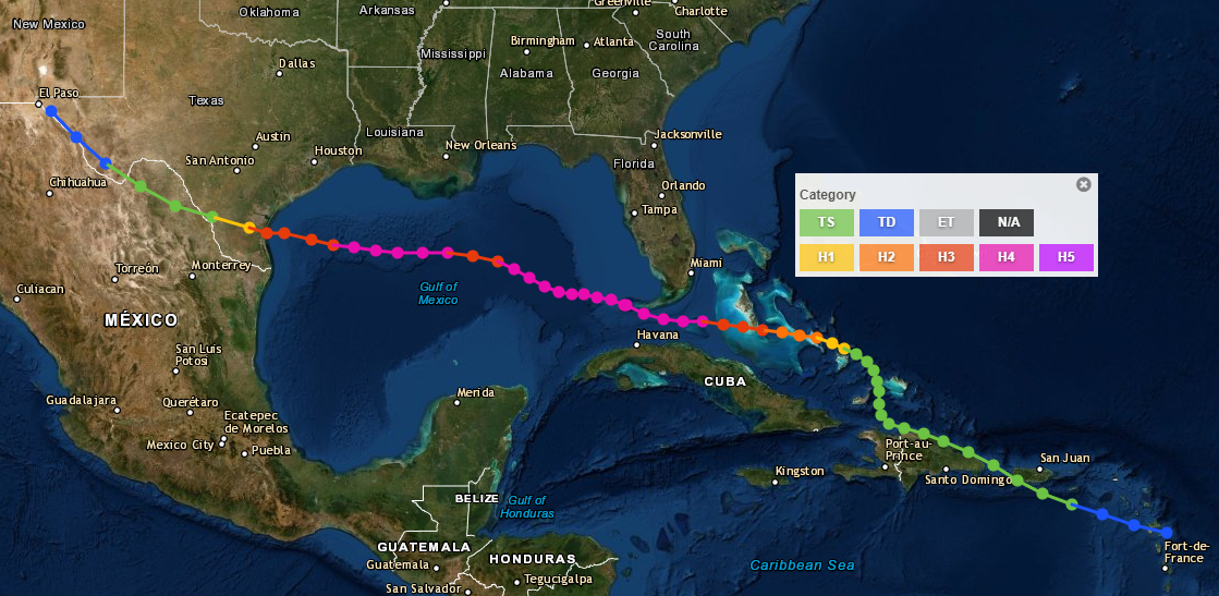
On September 14th of 2019, a century will have passed since the deadliest hurricane to affect the Coastal Bend of Texas made landfall between Baffin Bay and Corpus Christi. The hurricane devastated the Florida Keys as a Category 4 hurricane (Saffir-Simpson scale) on September 10th, 1919. The hurricane became a large storm over the Gulf of America and maintained its strength as a category 4 hurricane through the 13th. During this time, without the assistance of satellite imagery and radars, meteorologists lost track of this hurricane as ship reports from the Gulf of America temporarily ceased.
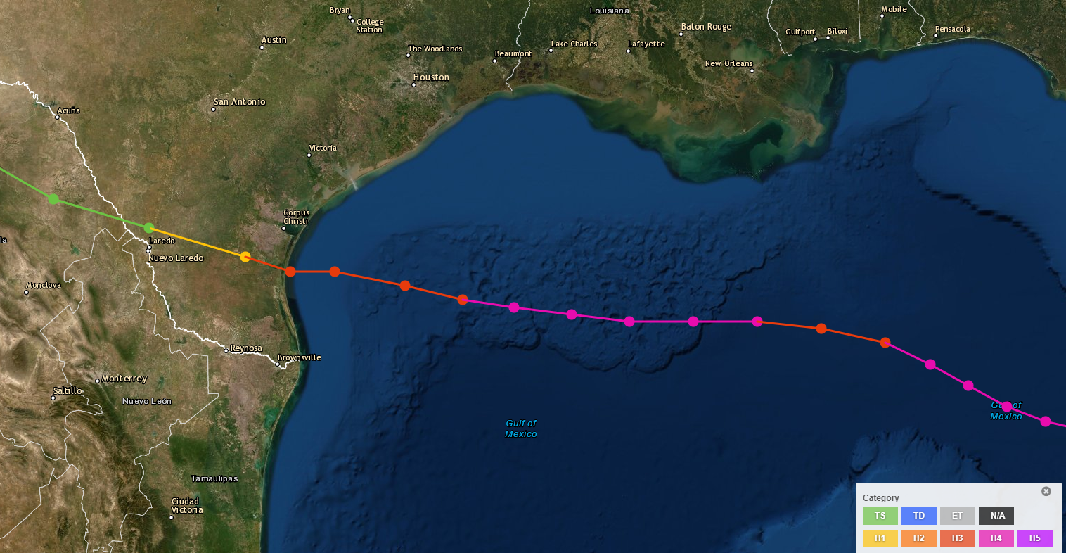
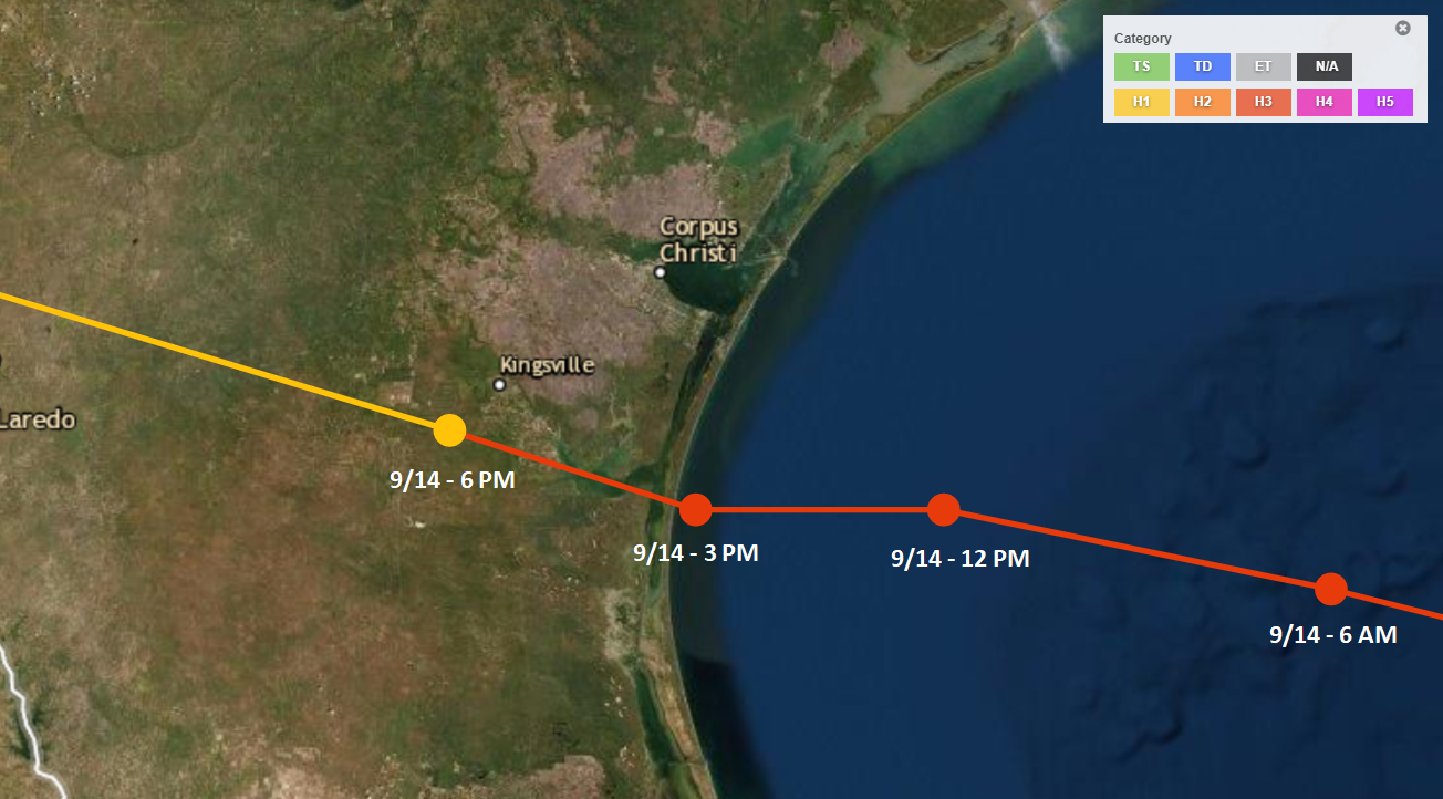
Early in the 20th century, citizens of Corpus Christi came to believe that their Sparkling City by the Sea was safe from hurricanes after several near misses occurred during the early 1900s. Two Category 4 hurricanes made landfall on the Texas coast in the previous 4 years - the first at Galveston in August of 1915 and the second near Baffin Bay in August of 1916. Some believed the barrier islands protected their city from devastating storm surge. By the early morning on the 14th of September, tides began to rise sharply at Port Aransas while the pressure steadily dropped as the northwest winds increased. The hurricane would weaken slightly before reaching the Middle Texas coast. The hurricane made landfall in the southern Coastal Bend as a Category 3 hurricane with sustained winds of 115 mph and a central pressure of 950 millibars.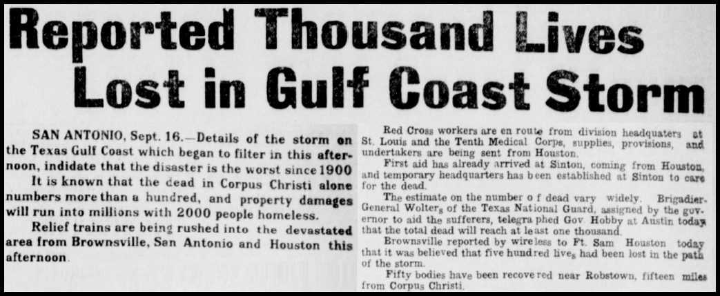

The following advisories were issued by the Weather Bureau Office in New Orleans.

Sept. 8, 1919
Following message sent from NEW at 912 am and received at 943 am "Advisory northeast storm warnings ten am
Jupiter to Key West and at Ft. Meyers, FL disturbance near or over Southwestern Bahamas apparently moving
WNW will cause strong northeast winds probably gales Monday extreme caution advised until further later
in day." signed Frankenfield

Sept. 9, 1919
Following message sent from NEW at 218 pm and received at 242 pm "Advisory one pm tropical storm eight am
over Florida Straits near Northeast Cuban coast moving WNW apparently and with considerable intensity
Hurricane warnings continued Key West and changes to northeast storm warning at other south Florida points
all Gulf shipping cautioned to exercise every precaution and wait further semidaily advises."
signed Frankenfield

Sept. 10, 1919
Following message sent from NEW at 715 am and received at 804 am "Advisory tropical disturbance apparently
over Florida Straits a short distance south of Key West with greatly increased intensity and probably moving
Northwest it will enter the Gulf of America Tuesday night and continue its northwest ward movement. All Gulf
shipping north of latitude twenty five warned to avoid the probable path of storm." signed Frankenfield

Following message sent from NEW at 243 pm and received at 314 pm "Advisory two pm tropical storm probably
over extreme southeastern Gulf of America this morning and moving northwest no reports thus far today from
immediate vicinity but warnings of last two days for all gulf shipping again repeated further advises
tonight." signed Frankenfield

Following message sent from NEW at 1132 pm and received at 806 am Sept. 11, 1919 "Advisory northeast storm
warnings ten thirty pm Bay St. Louis to Carrabelle, FL tropical storm probably about latitude twenty six
longitude eighty five moving northwest dangerous winds thursday over southeast Gulf and increasing
northeast winds over central and northeast gulf probably becoming strong on coat by Thursday night
Northeast storm warnings ordered New Orleans also." signed Frankenfield

Sept. 11, 1919
Following message sent from NEW at 320 pm and received at 437 pm "Advisory tropical storm in northcentral
Gulf of America still moving northwest probably near latitude 27 and longitude 87 will likely reach middle
gulf coast tonight and warnings of Wednesday night to take every precaution against dangerous winds
repeated hurricane warnings ordered Louisiana Coast to Carabelle Fla." signed Frankenfield

Following message sent from NEW at 909 pm and received at 947 pm "Advisory northwest storm warnings ordered
nine pm Port Arthur to Velasco disturbance now over North Central Gulf will probably cause increasing
northerly winds east of Texas Friday and caution advised." signed Dyke

Following message sent from NEW at 1006 pm and received at 1040 pm "Advisory storm now apparently near 27
and 88 still moving northwest will probably reach coast west of Mississippi River this for benefit
Railroad administration and other interest concerned" signed Frankenfield

Sept. 12, 1919
Following message sent from NEW at 920 am and received at 959 am "Hoist northwest storm warnings nine am
Texas Coast from West of Velasco to Corpus Christi change to Northeast warnings Pt. Arthur to Velasco
tropical disturbance in Gulf will cause increasing northerly winds next 24 hours probably reaching gale
force precautions should be continued." signed Dyke

Following message sent from NEW at 407 pm and received at 537 pm "Advisory hurricane warnings continued
Louisiana Coast no further definite information regarding storm now probably near latitude 27 and 89
further advices tonight if any further definite information received warning changed to storm northeast
Mobile and Pensacola and Hurricane warnings continued Mississippi Coast." signed Frankenfield

Following message sent from NEW at 1143 pm and received at 1207 am Sept. 13, 1919 "Advisory regret that no
radio reports were received from Gulf of America during the entire day increasing northeast winds at mouth
of Mississippi River indicate that storm is not far to southward of that locality and we can only repeat
previous messages urging great caution until further advices Saturday morning goodnight."
signed Frankenfield

Sept. 13, 1919
Following message sent from NEW at 907 am and received at 935 am "Advisory 815 am Louisiana Coast tropical
storm moving northward into Louisiana west of Mouth of Mississippi River dangerous easterly Gales probably
reaching hurricane force Saturday and Saturday night changing to Westerly on the West and southerly on east
coast Sunday morning." signed Dyke

Following message sent from NEW at 937 am and received at 958 am "Advisory warnings changed to Northwest
storm nine am Port Arthur to Velasco Texas Tropical disturbance moving into Louisiana west of Mississippi
River will cause strong northerly to westerly winds on east coast of Texas with moderate to fresh southerly
gales on extreme east coast." signed Dyke

Following message sent from NEW at 1200 pm and received at 1249 pm "Advisory tropical disturbance now close
to East Louisiana Coast apparently maintain Northwest movement but with evidence of recurving will cause
dangerously easterly gales East Louisiana and southern Mississippi and strong easterly winds southern
Alabama and extreme northwest Florida this afternoon winds will shift to southeast and south by Sunday
morning." signed Frankenfield

Following message sent from NEW at 654 pm and received at 737 pm "Hoist NW storm warnings 630 pm Texas
coast west of Velasco to Brownsville change to Northwest storm warning Port Arthur to Velasco. Disturbance
in Gulf will cause increasing easterly to northeasterly winds probably gales" signed Dyke

Following message sent from NEW at 1155 pm and received by telephone from Houston at 1200 am "Disturbance
apparently central in Gulf south of Galveston barometers on coast steady with slight rising tendency last
two hours and is low over entire west gulf as center of disturbance cannot be located watch barometer
carefully during night and take all possible precautions against rising winds and higher tides especially
if barometer begins to fall steadily." signed Frankenfield

Sept. 14, 1919
Following message sent from NEW at 830 am and received as 1030 am "Storm center now near south coast of
Texas with barometer 29.40 at Corpus Christi and 29.34 at Brownsville continue all precautions Sunday and
Sunday night against dangerous winds and high tides from mouth of Sabine River to Brownsville send ten am
one pm 3 pm special observations." signed Dyke

Wires down to Port Aransas.

// END //
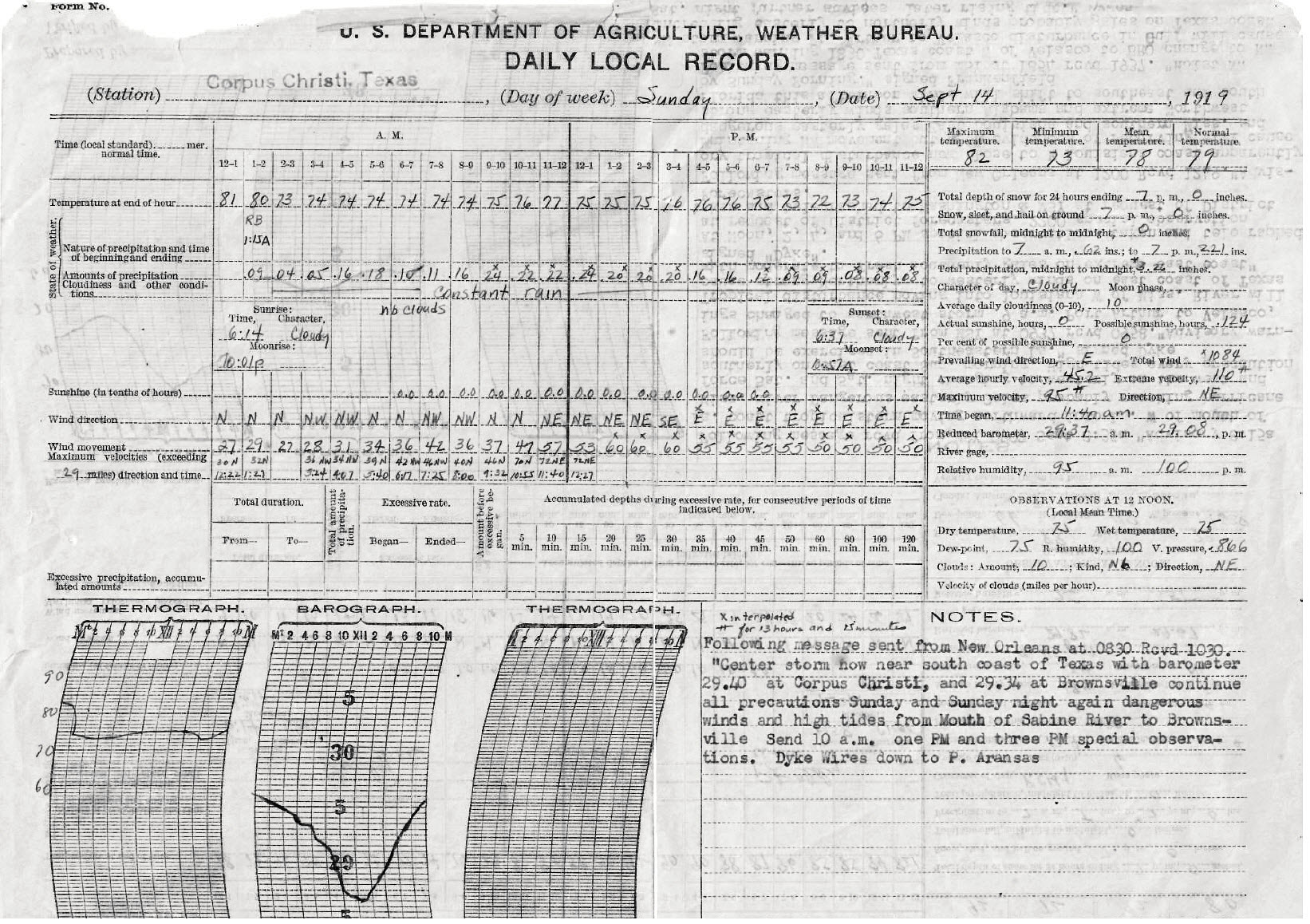
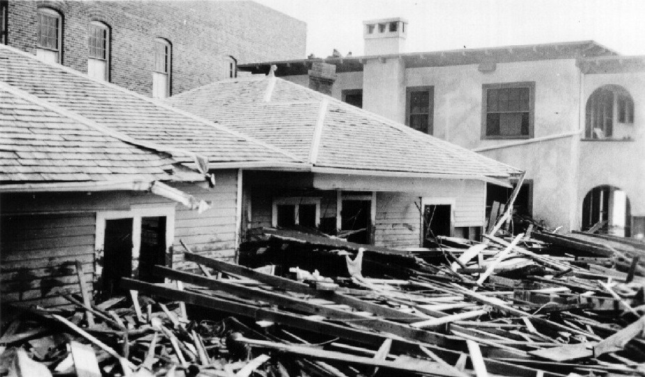
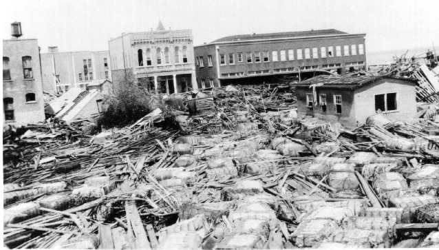
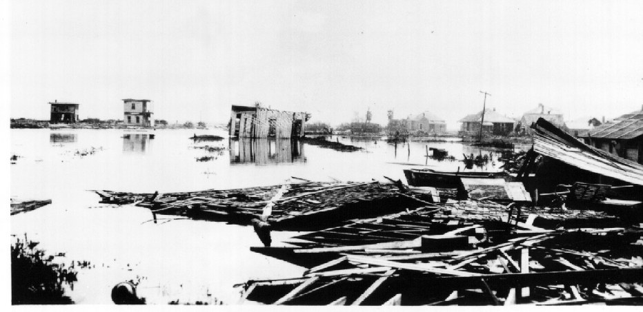
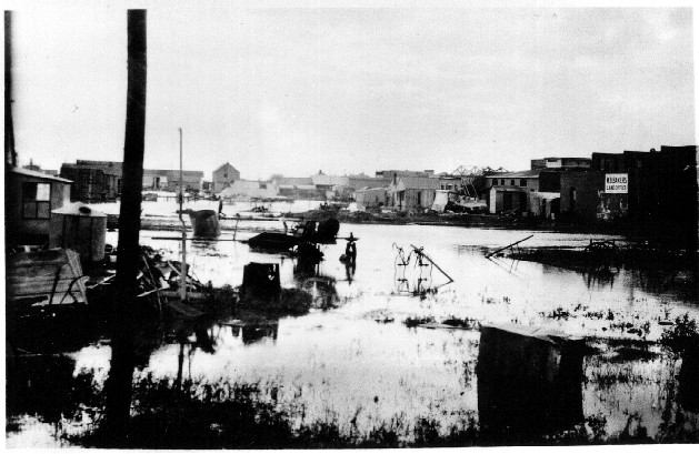
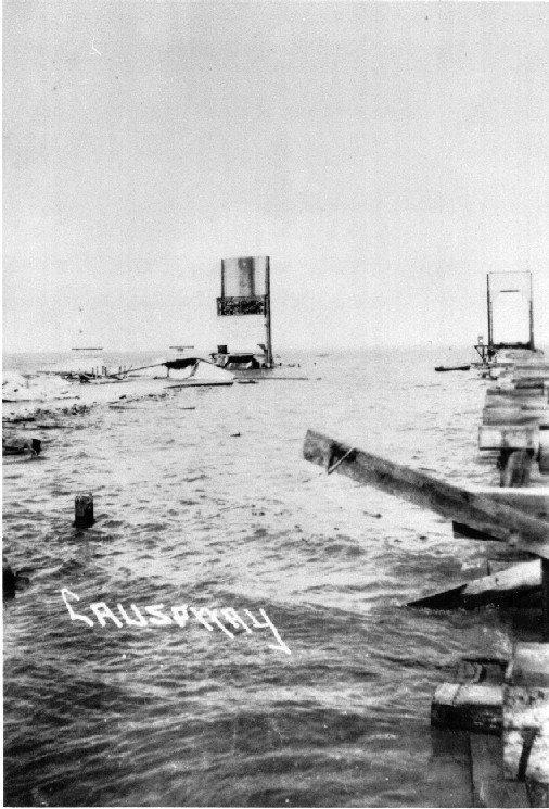
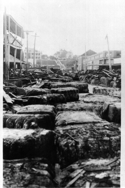
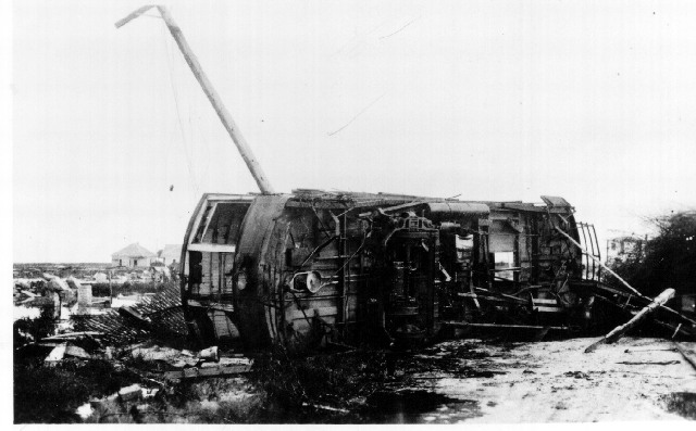
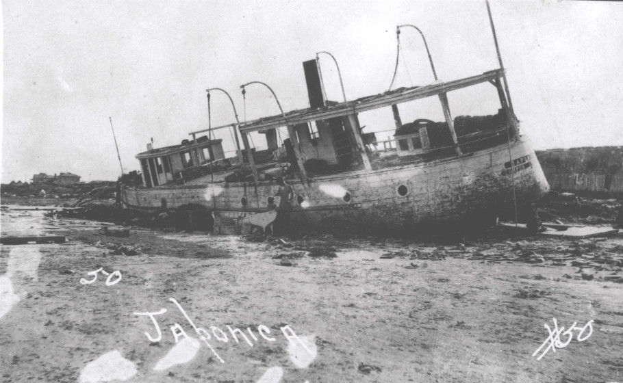
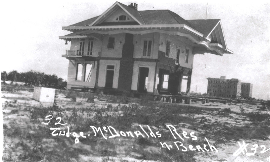
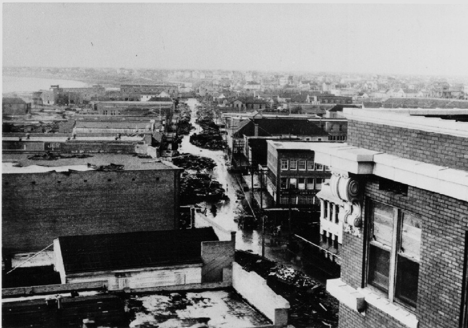
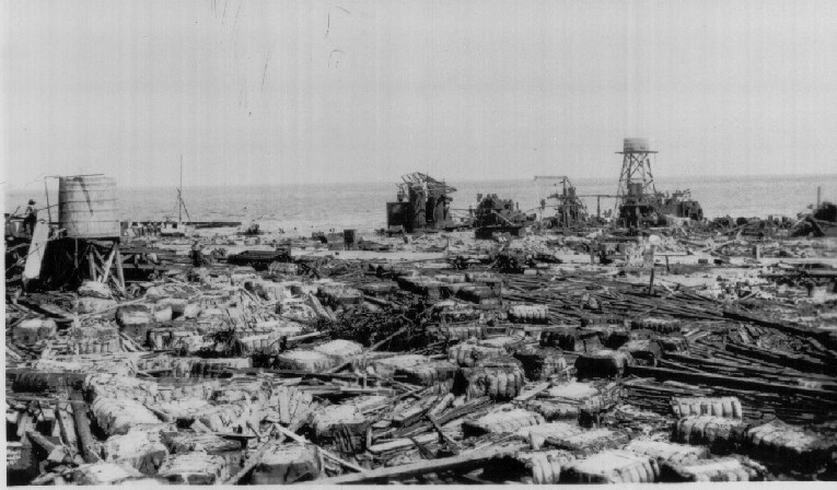
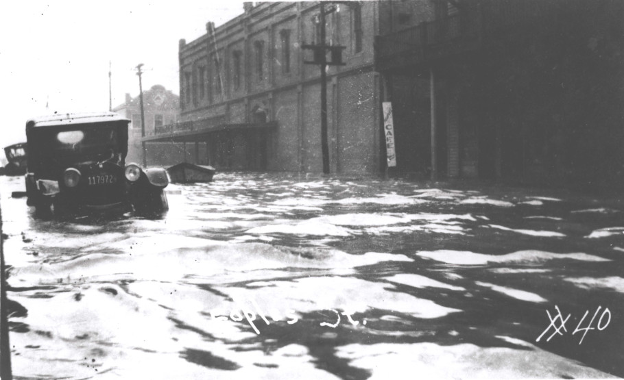
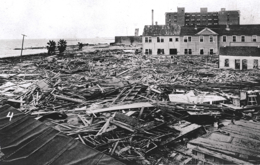
The following storm account summary is from the Corpus Christi Weather Bureau.

Tropical disturbance passed inland at some distance south of Corpus Christi today, the center of
the storm passed Corpus Christi at about 3 PM after which the barometer rose rapidly.

At 9:03 AM, the instrument shelter was struck by flying debris and partly demolished, and the
sunshine recorder broken. The cable leading to the sunshine recorder was broken off and the end
took water to such an extent that the electric circuit was crossed part of the time and this
interfered so much with the rainfall record after which time the rainfall record was useless. At
1:15 PM, flying debris struck the cable leading to the anemometer and partly severed that cable,
after which no record of wind velocity could be obtained. At the time the cable was severed, the
wind velocity was increasing again after a short period during which the velocity had been
considerably reduced, but not reduced as greatly as the record would indicate because during that
period the wind was from the east and the record was somewhat interfered with by eddies of wind
caused by the Nueces Hotel. After the severing of the cable, the wind attained high velocities
again, but was not nearly so gusty as it had been earlier in the day. It is true that the
average velocity was greater after the increase than before, but due to the steadiness of the
wind, maximum and extreme velocities were not so high as before.

At 4:12 PM, the east windows of the office were broken after being struck by objects which were
flying in the air and it was necessary to protect the main office and instruments as best we
could. The barometers were easily covered up and the desks and cases closed and covered with
rugs and old carpet, but no means could be taken that would insure the protection of the triple
register and it was removed to the other office rooms for protection.

The tide, which had been somewhat higher than normal during the day before, continued to rise
during the morning and by 9:45 AM was almost up to the gutter on the east side of Water Street.
As the barometer was falling rapidly and the water rising faster all the time, and as no
warnings had been received and the chance of such being received due to the shaky condition
of the telegraphic circuits, it was found that some action looking to protect the people
must be taken at once and the following warning was issued: "Direct people in exposed places to
seek places of safety". This was given to the police department and to a large number of persons
who had collected during the preceding hour and a half for the purpose of rendering assistance in
case of danger. Immediately, the police sent messengers in automobiles to the north end of town
and began distributing the warning from house to house. The men who had collected in the office
gave the warning distribution in the vicinity of the business district and telephoned to as many
as could be reached in that manner so that few were missed and many warned several times.

The water rose more rapidly and by noon was working its way rapidly up the gutters on the cross
streets between Water and Chaparral Streets. By 1 PM, the water covered Chaparral Street 18 inches
deep and was rising still faster. By 1:45 PM, the water was at least five feet deep in Chaparral
Street. After this time, the rise in the water was much slower but continued to rise until about
4 PM. The total depth of the highest water in the business district was about 11.5 feet above
mean sea level, and somewhat higher in the north end of town, and much higher toward the west end
of Nueces Bay where the bay narrows.

The destruction of life amounted to between 300 and 400 people in Corpus Christi and a considerable
number from places north of Corpus Christi Bay were lost. The loss of property has been estimated
from 6 to 20 million dollars, the latter including the depreciation in real estate values. After
the storm, there were nearly 5000 homeless people, not over 1000 of whom could repair and reoccupy
their former houses.

At the time the heaviest part of the tide struck Port Aransas, a number of large storage tanks
containing petroleum were burst and the entire flood on Corpus Christi Bay was covered with this
oil which helped to keep the waves down very much, but which covered all objects, including the
people who were caught in the water, with a coating of oil. The oil no doubt saved some buildings
from destruction but it caused great damage to goods and buildings by coating them with oil. Along
the southern portion of Corpus Christi Bay, the high clay bluff was worn away by heavy seas to a
depth of 40 feet in many places. Along the waterfront in the business district, the seas tore away
a considerable portion of land and in places took away nearly whole lots. This sediment that was
washed from the shoreline was piled on the lots farther from the waterfront and in places the
deposit was nearly two feet deep. In the north part of town, the shoreline was altered more than
in the business district.

As near as can be learned from the older inhabitants, the water rose nearly six feet higher than in
the storm of 1875. Previous to the storm of 1875, the only storm on record in which the water rose
very high was in 1828, but as no landmarks remain that would assist in determining the height of
the water on that occasion, comparisons cannot be made but if tradition is to be credited, the
present high water must have reached a considerable greater depth than in 1828. After the crest of
high water had been reached, the water receded rapidly, but not nearly so rapidly as it had risen.
At 4 AM of the 15th, it was about two feet deep in Chaparral Street
and it was about 48 hours later that it reached the height usually spoken of as the high water line.

// END //