National Weather Service United States Department of Commerce

Tracking a Significant Spring Storm Impacting the Central U.S. This Week

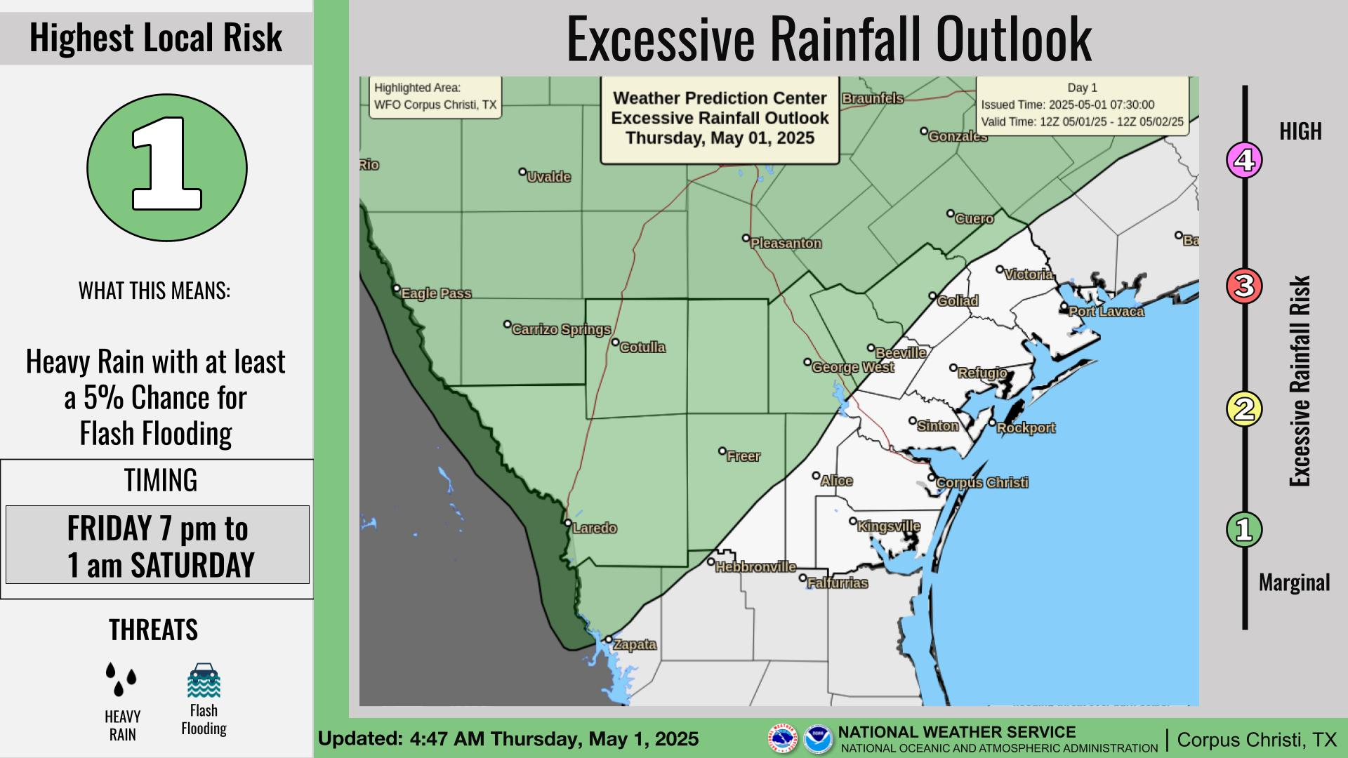
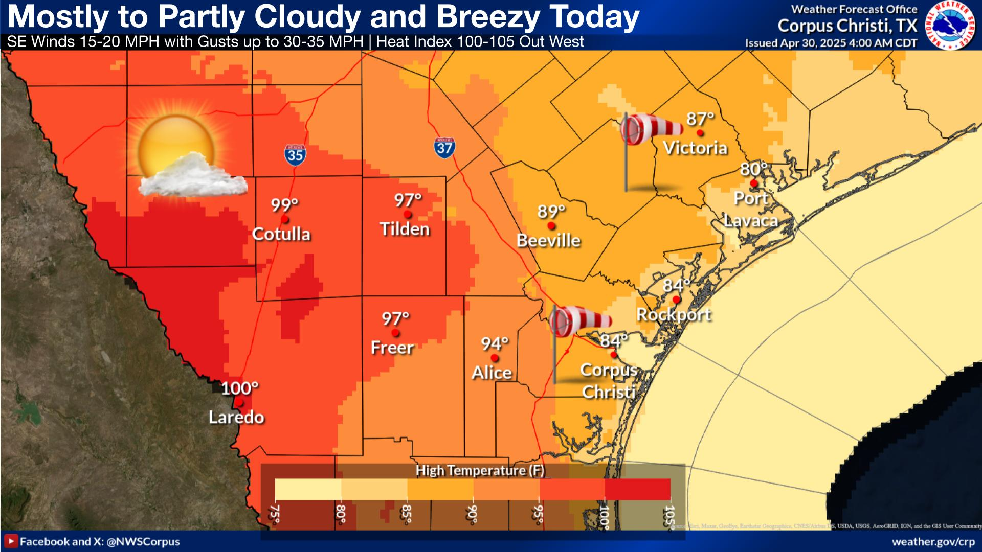
A significant storm will track across the central U.S. and into the Great Lakes through Thursday. Heavy snow and blowing snow is expected from the northern Plains into the Upper Midwest. Further south, severe thunderstorms are expected from the southern Plains into the Midwest as well as a multi-day excessive rain and flooding event Wednesday through Saturday from the Ozarks into the Ohio Valley. Read More >

Click a location below for detailed forecast.

Last Map Update: Tue, Apr 1, 2025 at 2:30:09 pm CDT

A Small Craft Advisory will be in effect tonight through at least Thursday morning across all the waters along the Middle Texas Coast. Expect south winds 15-25 knots gusting up to 30 knots and seas 6-9 feet. Inexperienced mariners should avoid navigating in these conditions.
Fog may linger over the waters this morning. Otherwise patchy fog inland will give way to clearing skies this afternoon. Breezy conditions this afternoon/evening will be accompanied by highs in the mid 80s to 90s.
Breezy conditions develop across area beaches this afternoon/evening with south winds increasing to 20-25 mph. There is a LOW risk of dangerous rip currents, but remember that LOW risk does not mean no risk. Please use caution at area beaches.
Skies will be partly cloudy tonight with breezy conditions across portions of South Texas. Patchy fog is possible across northeastern locales where winds are lighter. Overnight lows will be in the upper 60s to mid 70s across the region.
Partly cloudy skies are expected through the week with periods of fog in the mornings. Temperatures trend upwards, reaching into the triple digits by the middle to the end of the workweek. There's a moderate chance for showers this weekend.

 
Hourly Weather Roundup ( )
Location Sky/Weather Temp Dewpt RH Wind Baro Remarks
Alice
N/A
N/A
N/A
N/A
N/A
N/A
N/A
Beeville
N/A
N/A
N/A
N/A
N/A
N/A
N/A
Corpus Christi
N/A
N/A
N/A
N/A
N/A
N/A
N/A
Corpus Christi NAS
N/A
N/A
N/A
N/A
N/A
N/A
N/A
Cotulla
N/A
N/A
N/A
N/A
N/A
N/A
N/A
Kingsville NAS
N/A
N/A
N/A
N/A
N/A
N/A
N/A
Laredo
N/A
N/A
N/A
N/A
N/A
N/A
N/A
Port Lavaca
N/A
N/A
N/A
N/A
N/A
N/A
N/A
Rockport
N/A
N/A
N/A
N/A
N/A
N/A
N/A
Victoria
N/A
N/A
N/A
N/A
N/A
N/A
N/A
Note: "N/A" or "MISG" will be displayed if values are not available. In the LOCATION column, click on links for a list of recent observations at sites of interest. In the WIND column, VRB is "variable" and G is "gust". Wind speeds are in MPH. In the BARO (pressure) column, values are in inches. In the REMARKS column, HX is "heat index", WCI is "wind chill index", and VSB is "visibility" (if shown).
 
Text Product Selector
Video Briefing Weather Outlook Fcst Discussion Tropical Marine Tides
Rivers and Lakes Daily Rainfall Drought Fire Observations Satellite

Hourly Wx Graph Graphical Fcst Aviation Climate Past Events Hurricane Guide