See the Latest Briefing Slides
Go back to the NWS Cleveland, OH Main Page
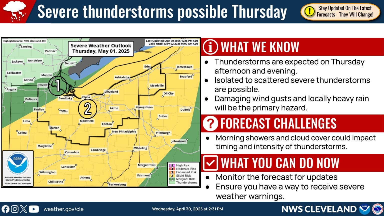
General Overview Graphics
|
|
|
|
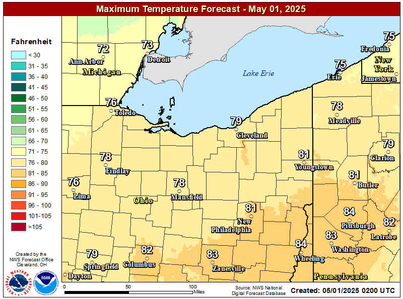
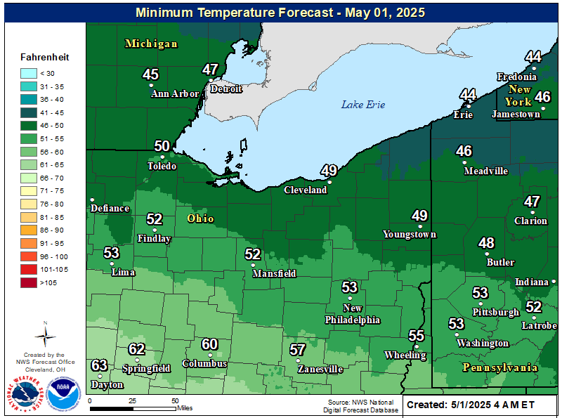
Today's High Temp | Today's Low Temp |
|
|
WPC Fronts 12-hr | WPC Fronts 24-hr |
|
|
WPC Fronts 36-hr | WPC Fronts 48-hr |
|
|
Severe Weather Resources
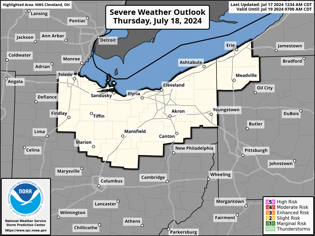
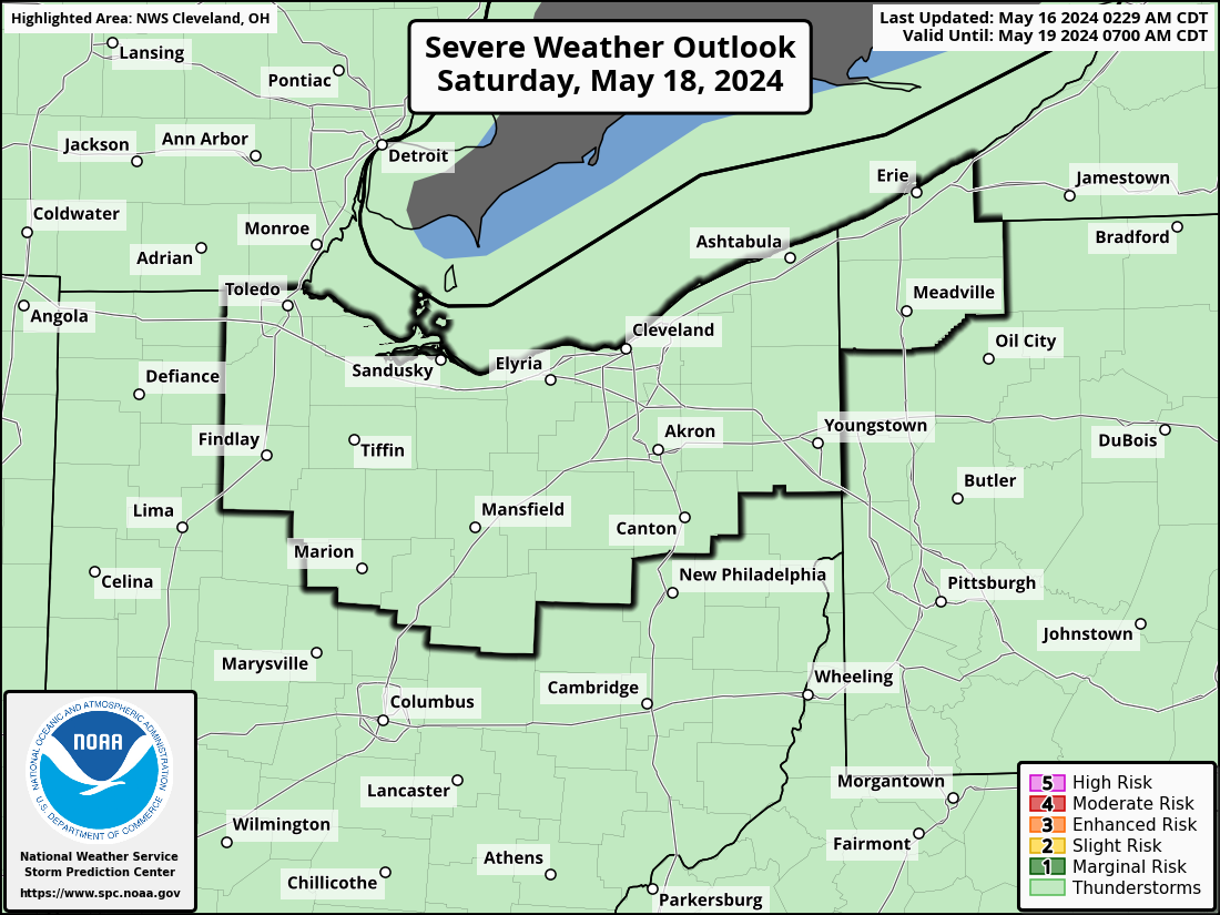
SPC Day 1 Discussion | SPC Day 2 Discussion |
|
|
SPC Day 3 Discussion | SPC Days 4-8 Discussion |
|
|
|
SPC Day 1 Wind | SPC Day 1 Hail | SPC Day 1 Tornado |
|
|
|
|
|
|
|
|
|
|
|
Hydrological Resources
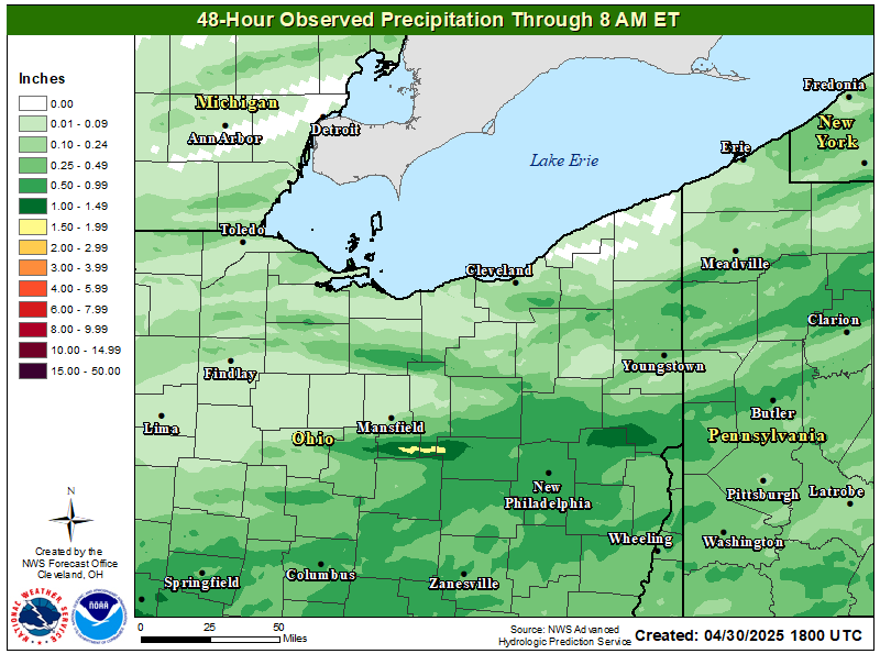
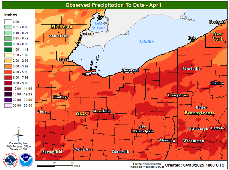
48-hr Observed Precip | Month To Date Precip |
|
|
Flood Products (Text Products & Previous Versions)
Flash Flood Warnings and Flash Flood Statements
Flood Statements (including Flood Advisories and River Flood Statements)
Flood Warnings (including River Flood Warnings)
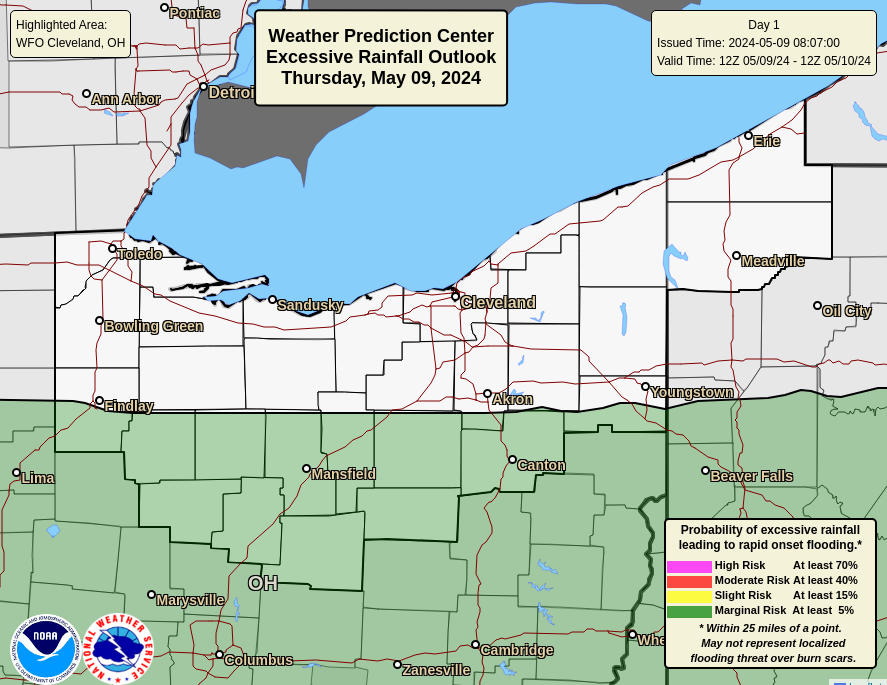
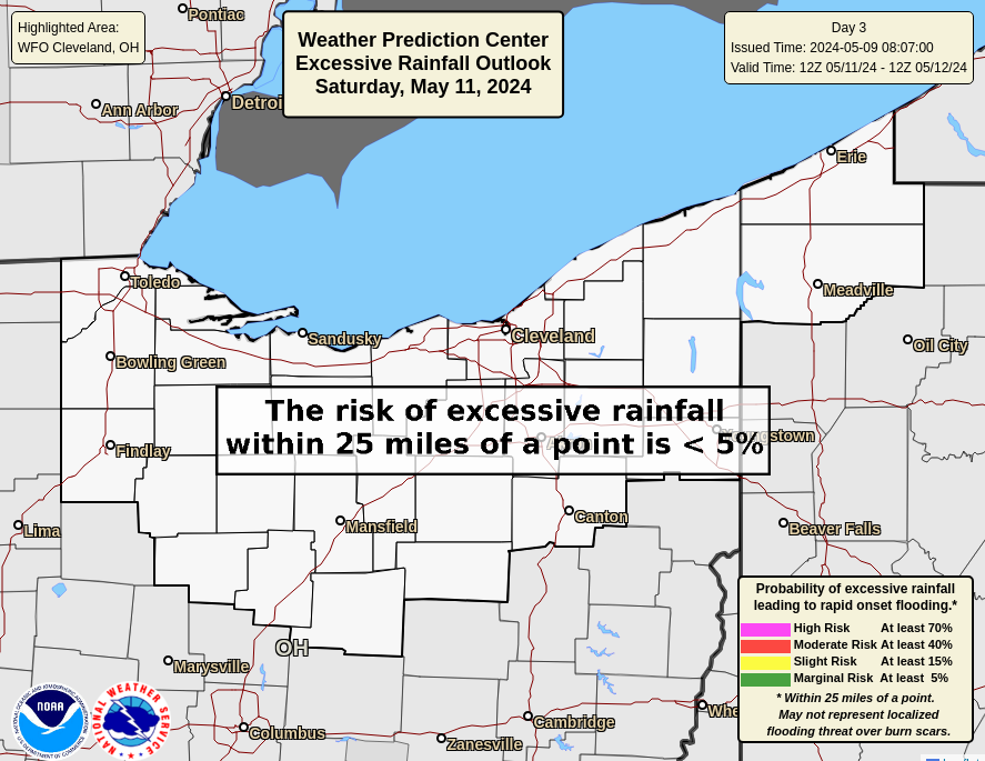
WPC Excessive Rainfall Discussion (Days 1-3)
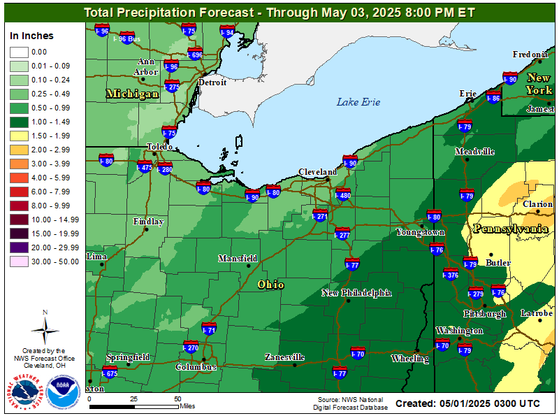
Storm Total Precipitation Forecast |
|
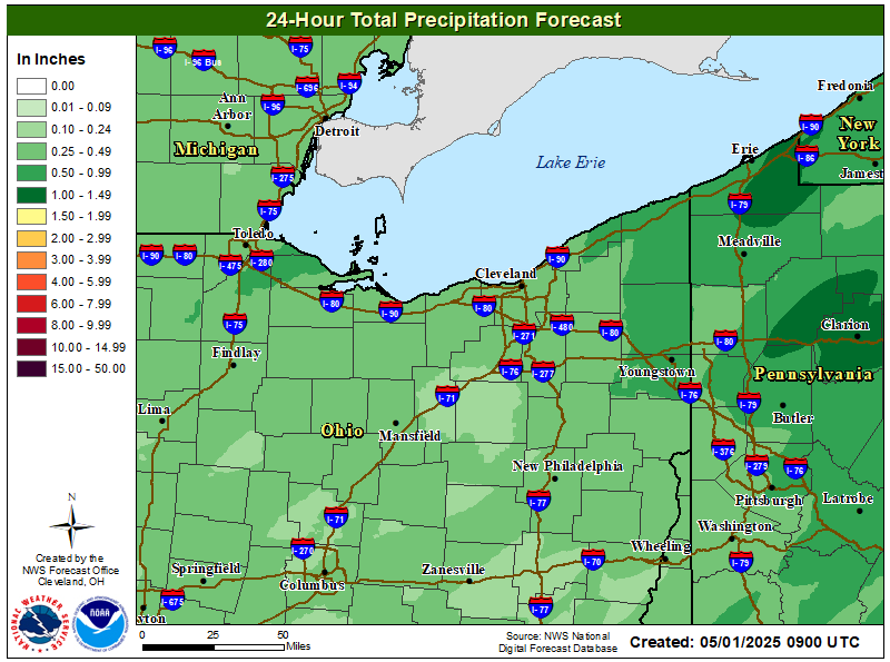
24-hr Rainfall Forecast | WPC Day 1 Excessive Rain Outlook |
|
|
WPC Day 2 Precip Forecast | WPC Day 2 Excessive Rain Outlook |
|
|
WPC Day 3 Precip Forecast | WPC Day 3 Excessive Rain Outlook |
|
|
WPC Days 1-7 Precip Forecast |
|
|
|
- |
|
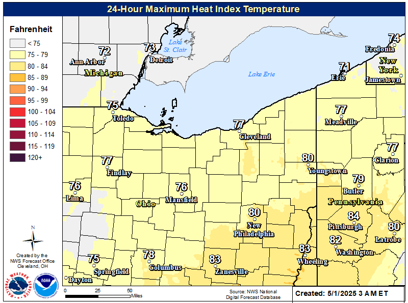
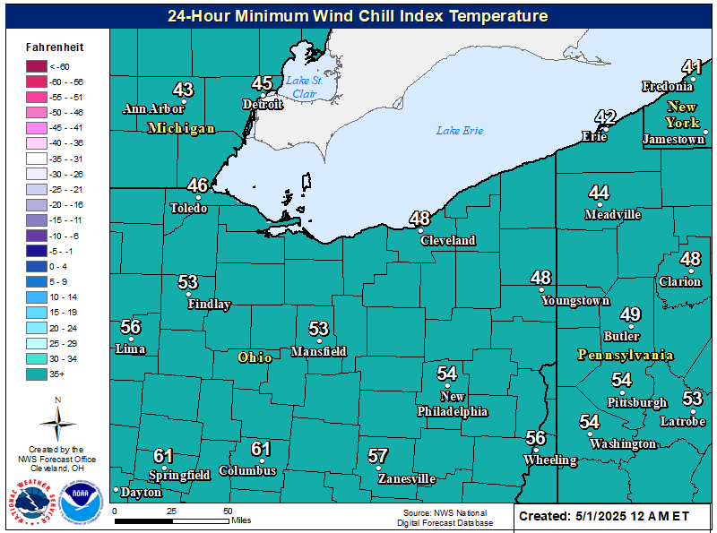
Extreme Heat/Cold Resources
659
WWUS71 KCLE 242235
NPWCLE
URGENT - WEATHER MESSAGE
National Weather Service Cleveland OH
635 PM EDT Mon Mar 24 2025
OHZ003-006>014-017>023-027>033-036>038-047-089-PAZ001>003-242345-
/O.CAN.KCLE.WI.Y.0006.000000T0000Z-250325T0000Z/
Lucas-Wood-Ottawa-Sandusky-Erie-Lorain-Cuyahoga-Lake-Geauga-
Ashtabula Inland-Hancock-Seneca-Huron-Medina-Summit-Portage-
Trumbull-Wyandot-Crawford-Richland-Ashland-Wayne-Stark-Mahoning-
Marion-Morrow-Holmes-Knox-Ashtabula Lakeshore-Northern Erie-
Southern Erie-Crawford-
Including the cities of Meadville, Rittman, North Ridgeville,
Middlefield, Ashland, Eastlake, Orrville, Findlay, Alliance,
Mount Vernon, Erie, Clyde, Huron, Wickliffe, Wadsworth, Fostoria,
Brunswick, Upper Sandusky, Aurora, Mentor, Titusville, Mount
Gilead, Massillon, Perrysburg, Ashtabula, Cardington, Port
Clinton, Streetsboro, Crestline, Carey, South Russell, Jefferson,
Youngstown, Willoughby, Edinboro, Oak Harbor, Burton, Kent, Avon
Lake, Niles, Wooster, Austintown, Marion, Canton, Chardon,
Warren, Union City, Elyria, Genoa, Willard, Lorain, Galion,
Killbuck, Bucyrus, Millersburg, Tiffin, Bellevue, Mansfield,
Willowick, Ravenna, Boardman, Toledo, Painesville, Geneva,
Chesterland, Orwell, Fremont, Norwalk, Roaming Shores, Sandusky,
Corry, Cleveland, Bainbridge, Akron, Andover, Conneaut, Bowling
Green, and Medina
635 PM EDT Mon Mar 24 2025
...WIND ADVISORY IS CANCELLED...
Advisory level wind gusts are no longer expected. West to southwest
winds 15 to 20 mph with gusts up to 30 mph will continue through
early this evening.
$$
13
Current Heat Index Observations (Map) | Current Wind Chill Observations (Map) |
|
|
Max Aparrent Temperature (24-hr) | Minimum Apparent Temperature (24-hr) |
|
|
CPC Temperature Outlook (6-10 days) | CPC Temperature Outlook (8-14 days) |
|
|
CPC Temperature Outlook (1 month) | CPC Temperature Outlook (3 months) |
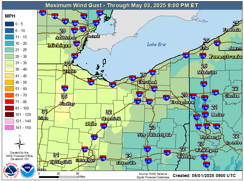
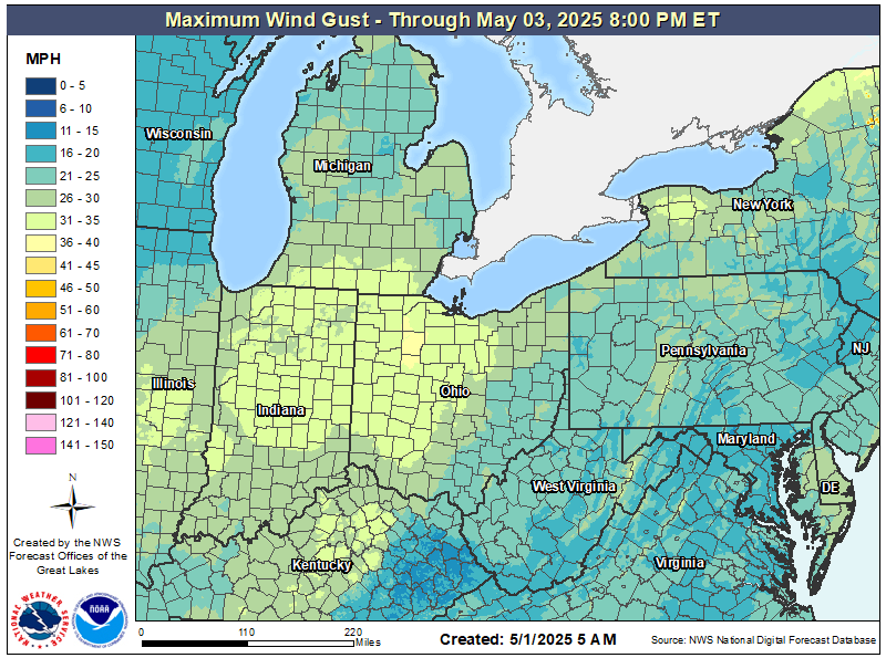
|
|
High Wind Resources
659
WWUS71 KCLE 242235
NPWCLE
URGENT - WEATHER MESSAGE
National Weather Service Cleveland OH
635 PM EDT Mon Mar 24 2025
OHZ003-006>014-017>023-027>033-036>038-047-089-PAZ001>003-242345-
/O.CAN.KCLE.WI.Y.0006.000000T0000Z-250325T0000Z/
Lucas-Wood-Ottawa-Sandusky-Erie-Lorain-Cuyahoga-Lake-Geauga-
Ashtabula Inland-Hancock-Seneca-Huron-Medina-Summit-Portage-
Trumbull-Wyandot-Crawford-Richland-Ashland-Wayne-Stark-Mahoning-
Marion-Morrow-Holmes-Knox-Ashtabula Lakeshore-Northern Erie-
Southern Erie-Crawford-
Including the cities of Meadville, Rittman, North Ridgeville,
Middlefield, Ashland, Eastlake, Orrville, Findlay, Alliance,
Mount Vernon, Erie, Clyde, Huron, Wickliffe, Wadsworth, Fostoria,
Brunswick, Upper Sandusky, Aurora, Mentor, Titusville, Mount
Gilead, Massillon, Perrysburg, Ashtabula, Cardington, Port
Clinton, Streetsboro, Crestline, Carey, South Russell, Jefferson,
Youngstown, Willoughby, Edinboro, Oak Harbor, Burton, Kent, Avon
Lake, Niles, Wooster, Austintown, Marion, Canton, Chardon,
Warren, Union City, Elyria, Genoa, Willard, Lorain, Galion,
Killbuck, Bucyrus, Millersburg, Tiffin, Bellevue, Mansfield,
Willowick, Ravenna, Boardman, Toledo, Painesville, Geneva,
Chesterland, Orwell, Fremont, Norwalk, Roaming Shores, Sandusky,
Corry, Cleveland, Bainbridge, Akron, Andover, Conneaut, Bowling
Green, and Medina
635 PM EDT Mon Mar 24 2025
...WIND ADVISORY IS CANCELLED...
Advisory level wind gusts are no longer expected. West to southwest
winds 15 to 20 mph with gusts up to 30 mph will continue through
early this evening.
$$
13
Current Wind Gust Observations (Map) | Current Station Plot Observations (Map) |
|
|
Wind Gust Forecast Day 1 | Regional Wind Gust Forecast |
|
|
|
|