***Please note, Central Region NWS offices in Michigan, Indiana, Illinois, Wisconsin, and Minnesota will also consolidate
Lake Effect Snow Warnings into Winter Storm Warnings. Eastern Region NWS offices in Ohio, New York, and
Pennsylvania will continue to issue Lake Effect Snow Warnings.***

We are implementing these changes through consolidation and reformatting of products.
Consolidation means reducing the number of Watch, Warning, and Advisory (WWA) hazard products
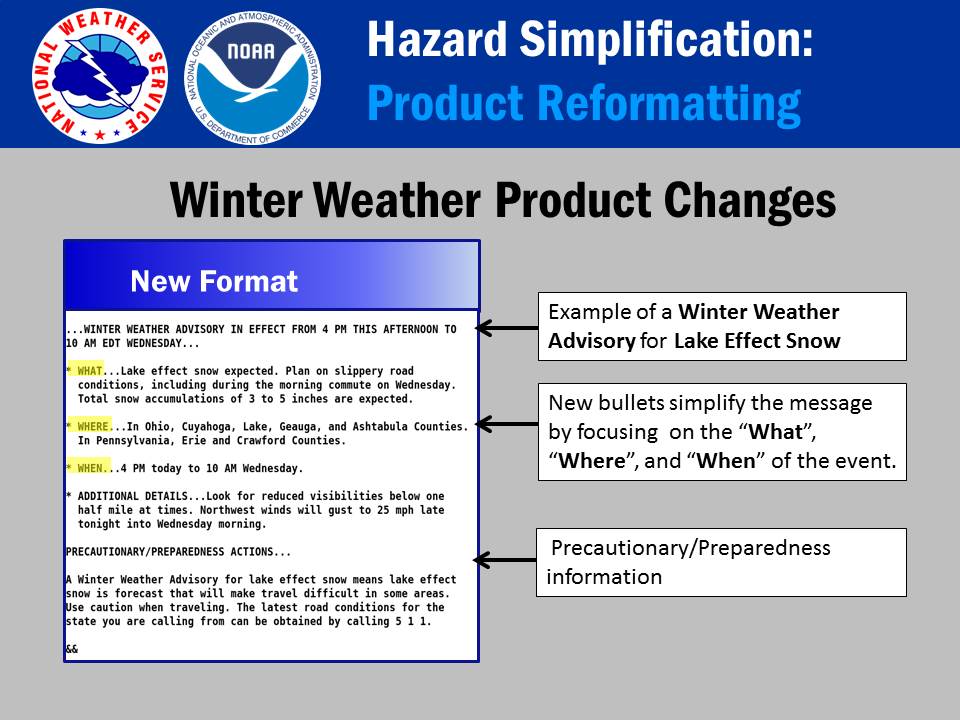
Reformatting means shortening, focusing and clarifying the body text within the WWA messages. This will feature a consistent message format that addresses What, Where, and When and recommended Precautionary/Preparedness Actions
The National Weather Service has been working to simplify products to better meet the needs of partners and the public. This project is called “Hazard Simplification”.
Proposals for simplification were developed based on multiple engagements that included focus groups, surveys and an interdisciplinary Workshop held in 2015.
Participants across all efforts included NWS employees, the public, broadcasters, emergency managers, social scientists, and other members of the Weather, Water and Climate Enterprise.
The first changes to the NWS Watch, Warning and Advisory (WWA) system will be implemented on October 1, 2017.
Winter Product Changes
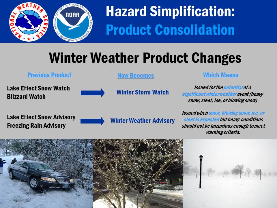
Starting October 1, 2017, NWS winter weather products will be consolidated as follows:
Consolidate Lake Effect Snow Advisory and Freezing Rain Advisory into Winter Weather Advisory
Consolidate Lake Effect Snow Watch and Blizzard Watch into Winter Storm Watch
Central Region NWS offices including those in Michigan, Indiana, Illinois, Wisconsin, and Minnesota will also consolidate Lake Effect Snow Warnings into Winter Storm Warnings. Eastern Region NWS offices including those in Ohio, New York, and Pennsylvania will continue to issue Lake Effect Snow Warnings.
In addition, all of the above products will be reformatted into a consistent message format as: “What”, “Where”, “When”, “Additional Details” and “Precautionary/ Preparedness Actions”.
This new format will be applied to all winter weather WWA products, including wind chill products
Flood Product Changes
Starting late winter/early spring of 2018 we will address the following consolidation and reformatting for our Flood Products:
Consolidate Flash Flood Watch into Flood Watch
Reformat all Flood products (including River Point products) into a “What, Where, When, Additional Details, and Precautionary/Preparedness Actions” format
Marine Product Changes
More complete information on the Hazard Simplification Project, including the project's history, options considered, focus group results, and additional reference materials can be found at www.weather.gov/hazardsimplification
FAQS ON HAZ SIMP WINTER AND FLOOD REFORMATTING AND CONSOLIDATION
Q: Why are you removing hazard specific products such as “Freezing Rain Advisory?”
A. It's true that the hazard specific headlines will become more generic in the Watch and Advisory terms. However, "Advisory" is the most poorly understood of the WWA terms overall. For many people it's not necessarily clear from the headline what level of impact is expected without going into the message anyway.
Q. Why are you reducing the number of NWS hazard products?
A. One of the primary project goals is to reduce the need to rely on "product headlines" to distinguish among the various impacts we experience across the country. Such reliance has now resulted in some 127 products across our hazard suite which we expect our users to understand. Instead, the new "What" section of the message will enable forecasters to express exactly what they wish to say in terms of hazard and impact - and in plain language.
Q. Tell me more about the benefits of removing “Freezing Rain Advisory." I’m still not convinced.
A. Going to just one Winter Weather Advisory eliminates the need to cancel and reissue products for hazards that have a similar impact. For example, forecasters sometimes cancel a Freezing Rain Advisory and reissue a Winter Weather Advisory for minor changes in winter hazard combinations. These types of cancellations and re-issuances can be very confusing to users - and will no longer be needed. Winter weather often includes a mixture of hazards from snow, sleet, freezing rain and blowing snow. Individual products for each hazard make it more difficult for users to understand the changing nature of winter events, and are even more challenging for our forecasters in the current product paradigm.
Q. Why remove “Blizzard Watch” and "Lake Effect Snow Watch”? These are very important hazards!
A. Going to one Winter Storm Watch eliminates the situations where forecasters may wait to issue any Watch at all because they are uncertain as to whether they should issue a Blizzard Watch or a Winter Storm Watch when blizzard conditions are possible. Blizzard conditions are extremely difficult to forecast and may be highly localized in nature. Lake effect snow is also very localized and can be difficult to pinpoint exact locations of intense snow bands before they develop.
With these new changes, forecasters will be able to issue one "Winter Storm Watch" as soon as they see the potential for significant winter weather - and they'll be able to express “blizzard conditions possible” in the "What" section. Forecasters are now able to indicate the possibility of lake effect snow within the "What" section, as heavy snow will have a similar impact and call to action regardless of its genesis. Forecasters are now able to be flexible and easily update specific hazard and impact expectations by editing the “What” section of the message, with no message cancellation and/or re-issuance needed.
Q. What are some other benefits of the reformatting and consolidation?
A. National policy will be updated to reflect consistent messaging for the hazard expectations within the first phrase of the "What" section. For example, all issuances where forecasters would have issued a “Blizzard Watch” in the past, the new “Winter Storm Watch” will be required to begin with the phrase “Blizzard conditions possible.” Similarly, "Freezing Rain Advisories" in the past will now begin with the phrase “Light Freezing Rain expected.” This will enable our partners to key in on these phrases for use in their applications as needed.
Also, as we continue to consolidate, our messages will increasingly be standardized into a common format, making it easy for users to find information quickly.
Q. What are the Haz Simp plans after winter consolidation and reformatting is completed?
A. We plan to consider additional hazards for consolidation and reformatting moving forward. We will be examining Marine and coastal products, as well as products for non-precipitating hazards, such as extreme temperature and wind. The goal is to consolidate products to support simplification goals and to shift focus from the current hazard products to a messaging paradigm that focuses on impacts.
Gary Garnet, Meteorologist in Charge, NWS Cleveland