Overview
|
A potent upper-level trough swept east across the Upper Great Lakes, extending a cold front east through the area. Thunderstorms developed along a pre-frontal trough ahead of the cold front Thursday afternoon across portions of Michigan and Indiana, and continued southeastward across northern OH and Northwest Pennsylvania into the evening hours. The environment was favorable for severe weather, particularly damaging wind gusts and large hail, and was characterized by steep mid-level lapse rates greater than 7 C/km, strong instability greater than 2000 J/kg, and modest bulk shear of 35 to 40 knots. Significant hail (2 inches in diameter in Westlake, OH and Corry, PA) and wind gusts (81 mph wind gust at Fairport Harbor, OH) were reported during the course of the event, resulting in numerous storm damage reports across the area. Several storms exhibited strong rotation on radar, resulting in 4 tornado warnings during the course of the event. Torrential rainfall also accompanied severe thunderstorms, leading to pockets of rate-driven flash flooding, especially within the Cleveland Metro area. |
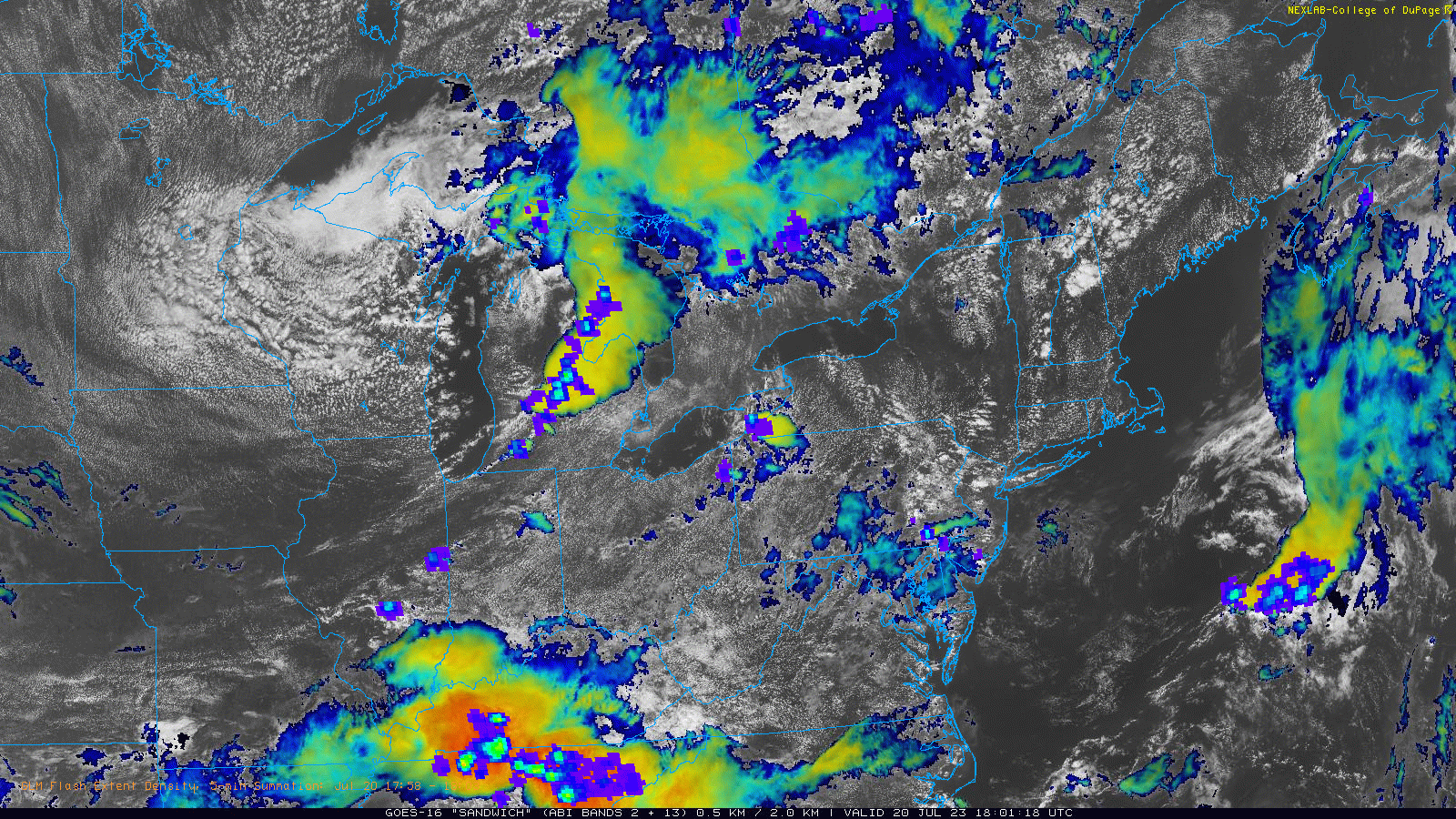 GOES-16 "sandwich" satellite product (visible and infrared) with the Geostationary Lightning Mapper (GLM) flash extent density overlaid. This loop is from 2 PM to 11 PM on July 20, 2023. |
Photos & Video
 |
 |
 |
 |
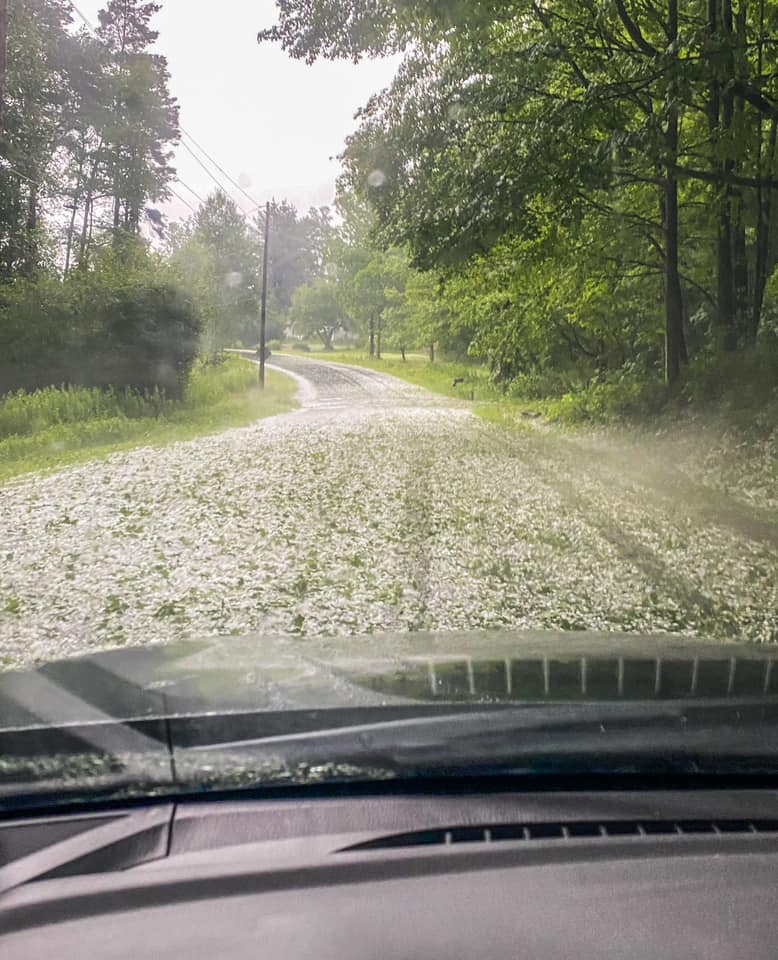
| Quarter-sized hail from Avon, OH. (Trent Magill) |
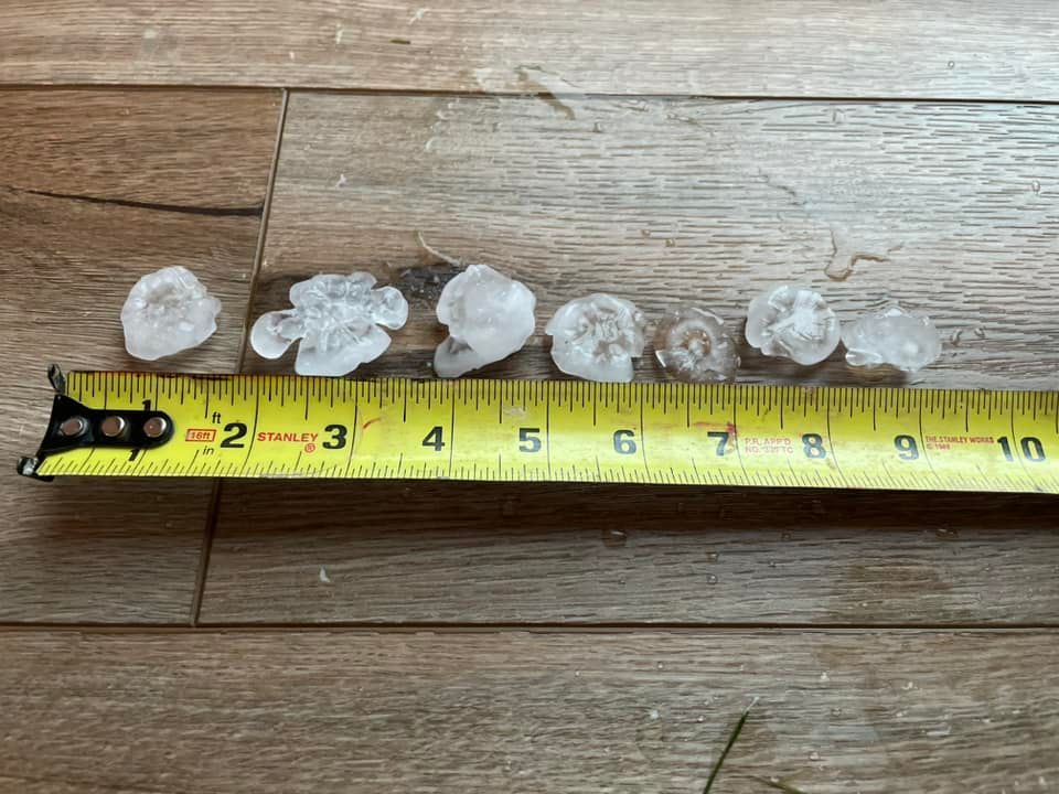
Large hail stones 2 inches or greater in Corry, PA. (Karalee Kemp) |
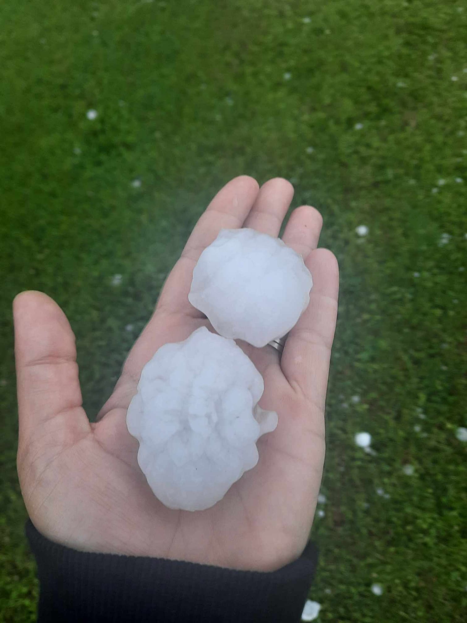
Large hail stone around 2 inches in Corry, PA. (Mary Beth Otteni Brown) |
Large hail stone around 2 inches in Corry, PA. (Mallory Whiteley) |
 |
 |
 |
 |
| Storms rolling in off of Lake Erie into Fairport Harbor, OH. (Aprell Burkey) |
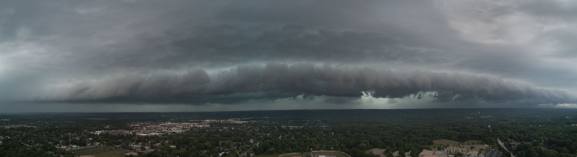
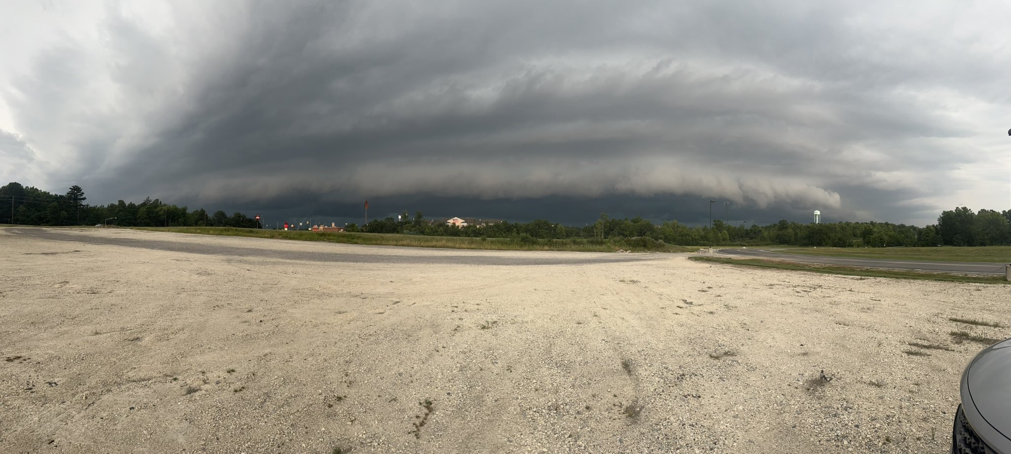
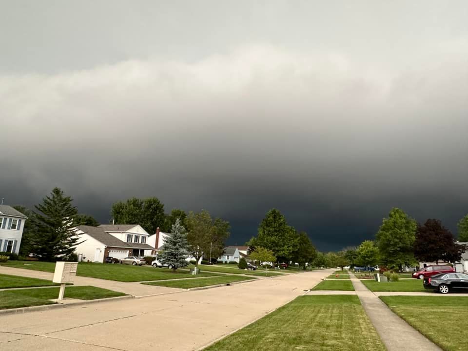
Shelf cloud picture from Medina, OH. (James Guilford) |
Shelf cloud picture from Austintown, OH. (Bill Bartholomew) |
Storm clouds rolling through Willoughby, OH. (Tom Allman) |
 |
 |
 |
 |
| Uprooted tree in Chagrin Falls, OH. (Melissa Keenan) |
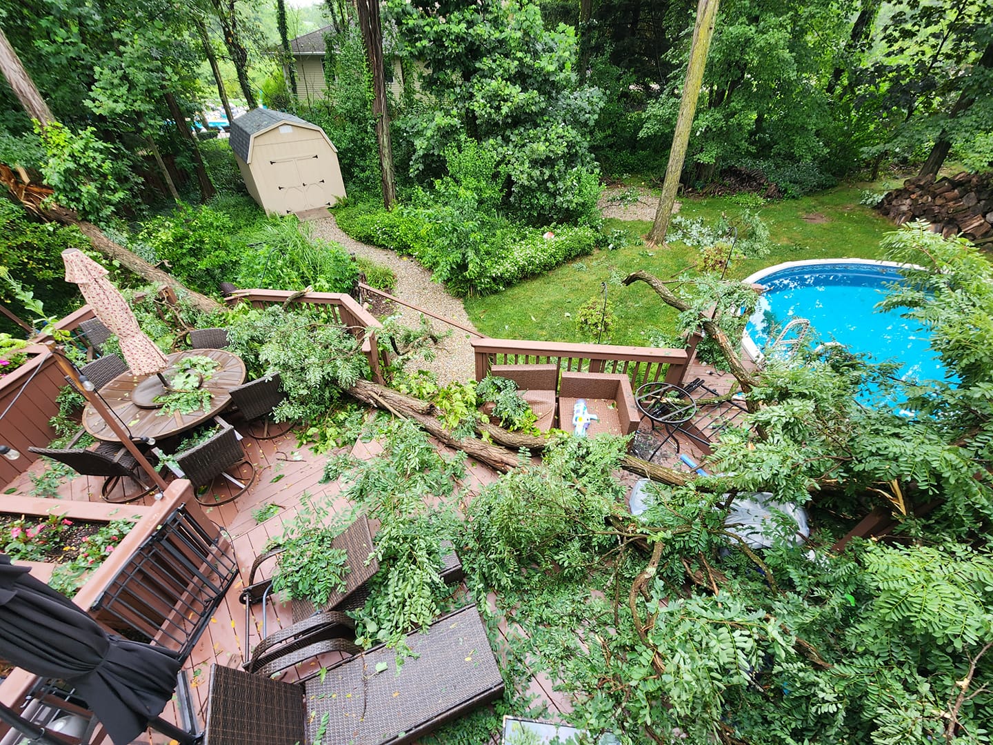
Storm damage in Macedonia, OH. (Brett Hanna) |
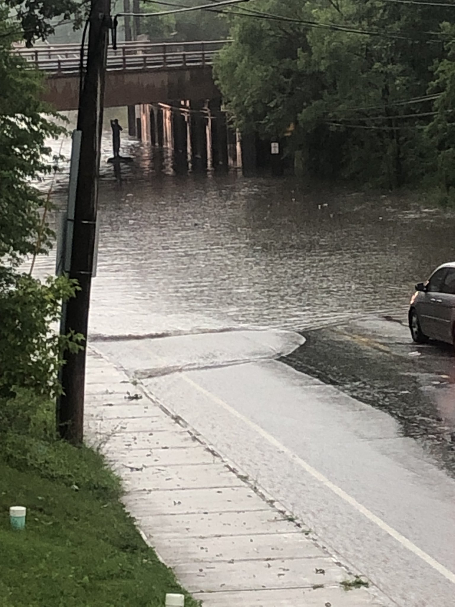
Street flooding in Brookpark, OH. (Chuck Madison) |
Hail accumulating on a roadway in Waterford, PA. (Larry Klick) |
Radar
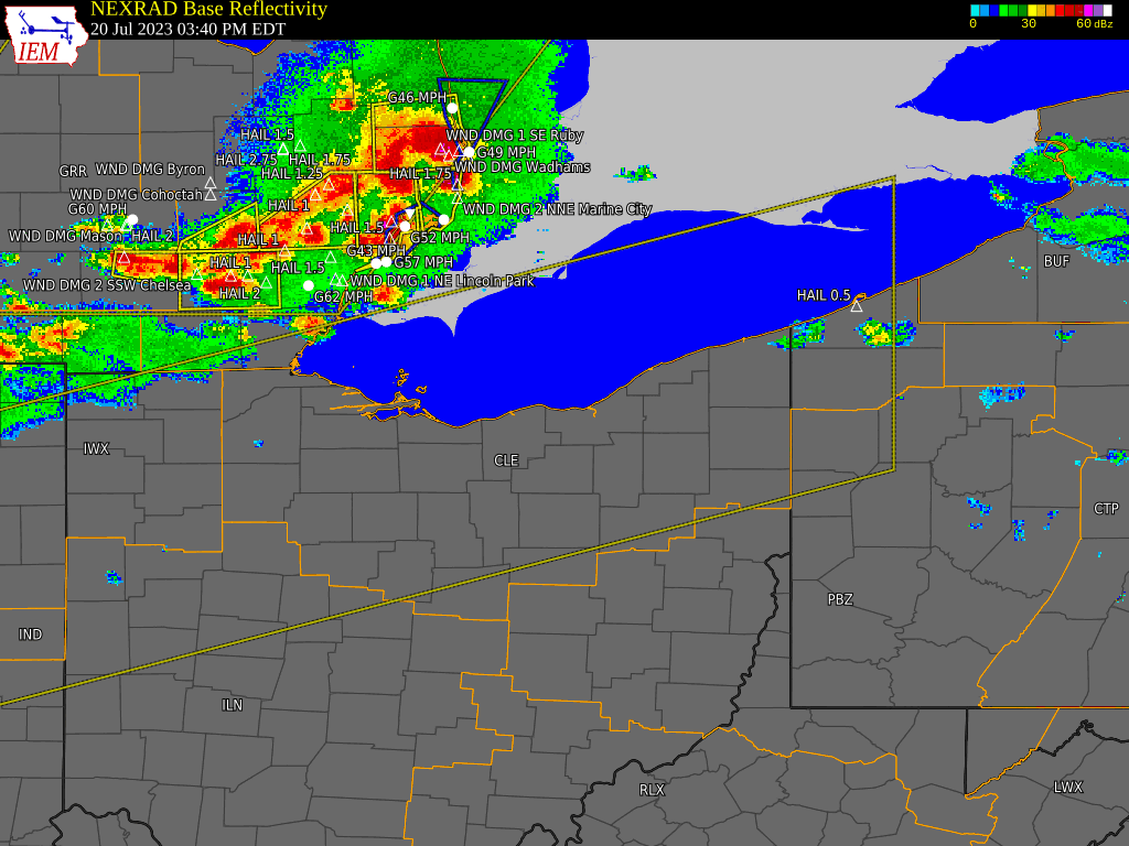 |
| Radar loop from 3:40 PM to 9:40 PM EDT on July 20, 2023. |
Storm Reports
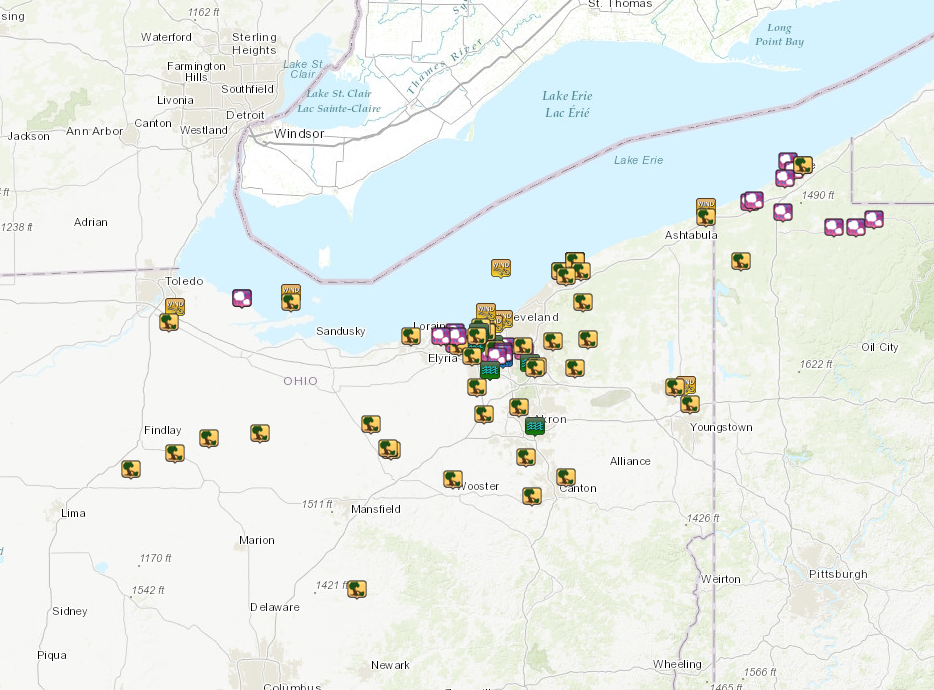 |
| Storm report map from July 20, 2023. |
736
NOUS41 KCLE 211004
PNSCLE
OHZ003-006>014-017>023-027>033-036>038-047-089-PAZ001>003-212204-

Public Information Statement
National Weather Service Cleveland OH
604 AM EDT Fri Jul 21 2023

...HAIL REPORTS...

Location                     Size      Time/Date       Lat/Lon
Corry                        2.00 in   0630 PM 07/20   41.93N/79.64W
Westlake                     2.00 in   0705 PM 07/20   41.45N/81.93W
1 W Parma                    1.75 in   0718 PM 07/20   41.38N/81.75W
3 S Mckean                   1.50 in   0554 PM 07/20   41.96N/80.14W
1 SSE Brooklyn               1.50 in   0720 PM 07/20   41.41N/81.74W
Seven Hills                  1.50 in   0725 PM 07/20   41.39N/81.68W
Seven Hills                  1.50 in   0745 PM 07/20   41.38N/81.68W
7 NNE Oak Harbor             1.25 in   0540 PM 07/20   41.61N/83.11W
1 WSW Bedford                1.25 in   0740 PM 07/20   41.39N/81.56W
Erie                         1.00 in   0139 PM 07/20   42.13N/80.08W
3 NNW Erie                   1.00 in   0145 PM 07/20   42.17N/80.11W
1 ENE Girard                 1.00 in   0510 PM 07/20   42.01N/80.30W
1 W Union City               1.00 in   0605 PM 07/20   41.90N/79.86W
Elgin                        1.00 in   0615 PM 07/20   41.90N/79.74W
7 NNE Oak Harbor             1.00 in   0539 PM 07/20   41.61N/83.11W
Avon                         1.00 in   0656 PM 07/20   41.45N/82.02W
1 WNW North Olmsted          1.00 in   0704 PM 07/20   41.42N/81.94W
1 NW Westlake                1.00 in   0705 PM 07/20   41.47N/81.94W
Brooklyn Heights             1.00 in   0726 PM 07/20   41.41N/81.66W
1 ESE Parma                  1.00 in   0740 PM 07/20   41.37N/81.71W
1 SE Parma                   1.00 in   0749 PM 07/20   41.37N/81.71W
Girard                       0.88 in   0510 PM 07/20   42.00N/80.32W
3 SW Erie                    0.50 in   0433 PM 07/20   42.10N/80.13W

...HIGHEST WIND REPORTS...

Location                     Speed     Time/Date       Lat/Lon
Fairport, OH                 81 MPH    0630 PM 07/20   41.76N/81.28W
Fairport, OH                 65 MPH    0618 PM 07/20   41.76N/81.28W
Toledo                       59 MPH    0618 PM 07/20   41.57N/83.48W
Cleveland - Edgewater        58 MPH    0718 PM 07/20   41.50N/81.73W
Fairport, OH                 56 MPH    0606 PM 07/20   41.76N/81.28W
Cleveland                    56 MPH    0648 PM 07/20   41.52N/81.68W
Conneaut Light               56 MPH    0623 PM 07/20   41.98N/80.56W
9 NE Port Clinton            51 MPH    0600 PM 07/20   41.63N/82.84W
Youngstown                   49 MPH    0749 PM 07/20   41.25N/80.67W
4 NNE Lakewood               47 MPH    0700 PM 07/20   41.55N/81.77W
13 NNW Bratenahl             45 MPH    0600 PM 07/20   41.73N/81.69W

...PRECIPITATION REPORTS...

Location                     Amount    Time/Date       Lat/Lon
1 SSW Seven Hills            3.00 in   0809 PM 07/20   41.36N/81.68W
&&

**METADATA**
:7/20/2023,0809 PM, OH, Cuyahoga, 1 SSW Seven Hills, , , 41.3617, -81.6847, RAIN_24, 3, Inch, Trained Spotter, 24 hour rainfall,
:7/20/2023,0648 PM, OH, Cuyahoga, Cleveland, , , 41.52, -81.68, PKGUST, 56, mph, ASOS, Peak Wind Gust,
:7/20/2023,0606 PM, OH, Lake, Fairport, OH, , , 41.7598, -81.2811, PKGUST, 56, mph, NOS-NWLON, Peak Wind Gust,
:7/20/2023,0618 PM, OH, Lake, Fairport, OH, , , 41.7598, -81.2811, PKGUST, 65, mph, NOS-NWLON, Peak Wind Gust,
:7/20/2023,0630 PM, OH, Lake, Fairport, OH, , , 41.7598, -81.2811, PKGUST, 81, mph, NOS-NWLON, Peak Wind Gust,
:7/20/2023,0600 PM, OH, Ottawa, 9 NE Port Clinton, , , 41.629, -82.841, PKGUST, 51, mph, NDBC, Peak Wind Gust,
:7/20/2023,0749 PM, OH, Trumbull, Youngstown, , , 41.25, -80.6667, PKGUST, 49, mph, ASOS, Peak Wind Gust,
:7/20/2023,0618 PM, OH, Wood, Toledo, , , 41.5667, -83.4833, PKGUST, 59, mph, ASOS, Peak Wind Gust,

Observations are collected from a variety of sources with varying
equipment and exposures. We thank all volunteer weather observers
for their dedication. Not all data listed are considered official.

$$
476
NWUS51 KCLE 220251
LSRCLE
Preliminary Local Storm Report...Summary
National Weather Service Cleveland OH
1051 PM EDT Fri Jul 21 2023
..TIME... ...EVENT... ...CITY LOCATION... ...LAT.LON...
..DATE... ....MAG.... ..COUNTY LOCATION..ST.. ...SOURCE....
..REMARKS..
0139 PM Hail Erie 42.13N 80.08W
07/20/2023 E1.00 inch Erie PA Public
Various hail sizes from penny to quarter
size.
0143 PM Hail 3 E Erie 42.15N 80.03W
07/20/2023 E1.25 inch Erie PA Public
-Delayed report- Video and photos of hail
approximately the size of half dollars 3
miles east of downtown Erie.
0145 PM Hail 3 NNW Erie 42.17N 80.11W
07/20/2023 E1.00 inch Erie PA NWS Employee
Quarter Hail at Presque Isle State Park.
0146 PM Tstm Wnd Dmg 3 E Erie 42.15N 80.03W
07/20/2023 Erie PA Public
-Delayed report- Multiple large trees downed
across road 3 miles east of downtown Erie.
0433 PM Hail 3 SW Erie 42.10N 80.13W
07/20/2023 E0.50 inch Erie PA NWS Employee
Estimated half inch hail at Pittsburgh Ave
and W 26th Street in Erie. Time estimated
via radar.
0510 PM Hail Girard 42.00N 80.32W
07/20/2023 E0.88 inch Erie PA Trained Spotter
0510 PM Hail 1 ENE Girard 42.01N 80.30W
07/20/2023 E1.00 inch Erie PA Public
Report from mPING: Quarter (1.00 in.).
0539 PM Hail 7 NNE Oak Harbor 41.61N 83.11W
07/20/2023 E1.00 inch Ottawa OH Public
Report from mPING: Quarter (1.00 in.) hail.
0540 PM Hail 7 NNE Oak Harbor 41.61N 83.11W
07/20/2023 E1.25 inch Ottawa OH Public
Report from mPING: Half Dollar (1.25 in.)
hail.
0545 PM Tstm Wnd Dmg 7 WNW Marblehead 41.59N 82.84W
07/20/2023 Ottawa OH Public
30 foot tall tree down on a house at Catawba
Point.
0554 PM Hail 3 S Mckean 41.96N 80.14W
07/20/2023 E1.50 inch Erie PA Public
0600 PM Tstm Wnd Gst 9 NW Marblehead 41.63N 82.84W
07/20/2023 M51 MPH Ottawa OH Mesonet
Mesonet station SBIO1 9 NE Port Clinton.
0600 PM Tstm Wnd Gst 13 NNW Bratenahl 41.73N 81.69W
07/20/2023 M45 MPH LEZ166 OH Mesonet
Mesonet station 45164 13 NNW Bratenahl.
0605 PM Hail 1 W Union City 41.90N 79.86W
07/20/2023 E1.00 inch Erie PA 911 Call Center
0606 PM Tstm Wnd Gst 1 NNW Fairport Harbor 41.76N 81.28W
07/20/2023 M56 MPH Lake OH Buoy
Buoy station FAIO1 Fairport, OH.
0615 PM Hail Elgin 41.90N 79.74W
07/20/2023 E1.00 inch Erie PA Trained Spotter
Hail damaged some vehicles and also tore off
window screens.
0617 PM Tstm Wnd Dmg Stony Ridge 41.51N 83.51W
07/20/2023 Wood OH 911 Call Center
Tree limb and power line downed. Time
estimated via radar.
0617 PM Tstm Wnd Dmg Mentor-on-the-Lake 41.72N 81.36W
07/20/2023 Lake OH NWS Employee
-Delayed Report- Numerous reports from a
retired NWS employee, broadcast
meteorologist, and the public of widespread,
extensive tree and power-line damage in
Mentor-on-the-Lake. Outdoor structures were
damaged at Mentor Lagoons and some trees
fell on houses.
0618 PM Tstm Wnd Gst 1 SSE Walbridge 41.57N 83.48W
07/20/2023 M59 MPH Wood OH ASOS
ASOS station KTDZ Toledo.
0618 PM Tstm Wnd Dmg Mentor 41.70N 81.33W
07/20/2023 Lake OH Public
-Delayed Report- Two pictures received on
social media of a tree and large limb downed
on cars in separate residential driveways in
Mentor.
0618 PM Tstm Wnd Gst 1 NNW Fairport Harbor 41.76N 81.28W
07/20/2023 M65 MPH Lake OH Buoy
Buoy station FAIO1 Fairport, OH.
0618 PM Tstm Wnd Dmg 1 NE Mentor-on-the-Lake 41.72N 81.36W
07/20/2023 Lake OH Public
Power pole snapped and hit a car, large tree
branch on wires near the yacht club and
large tree uprooted.
0623 PM Tstm Wnd Gst 4 NNE Conneaut 41.98N 80.56W
07/20/2023 M56 MPH LEZ149 OH Mesonet
Mesonet station XCON Conneaut Light.
0627 PM Tstm Wnd Dmg Fairport Harbor 41.76N 81.28W
07/20/2023 Lake OH Public
-Delayed Report- Siding partially peeled off
the second story of a house in Fairport
Harbor.
0627 PM Tstm Wnd Dmg 1 NNW Fairport Harbor 41.76N 81.28W
07/20/2023 Lake OH Public
Widespread tree damage in Fairport Harbor.
Time estimated via radar.
0628 PM Tstm Wnd Dmg Painesville 41.72N 81.25W
07/20/2023 Lake OH Public
-Delayed Report- Tree limbs downed in
Painesville.
0630 PM Hail Corry 41.93N 79.64W
07/20/2023 M2.00 inch Erie PA Public
North side of Corry, PA.
0630 PM Tstm Wnd Gst 1 NNW Fairport Harbor 41.76N 81.28W
07/20/2023 M81 MPH Lake OH Buoy
Buoy station FAIO1 Fairport, OH.
0631 PM Tstm Wnd Dmg 1 N Lorain 41.45N 82.18W
07/20/2023 Lorain OH 911 Call Center
Tree down on house. Time estimated from
radar.
0632 PM Tstm Wnd Dmg Conneaut 41.94N 80.56W
07/20/2023 Ashtabula OH Public
-Delayed Report- Multiple large limbs and
trees down in Conneaut, some onto roadways.
0648 PM Tstm Wnd Gst 3 N Cleveland 41.52N 81.68W
07/20/2023 M56 MPH Cuyahoga OH ASOS
ASOS station KBKL Cleveland.
0650 PM Tstm Wnd Dmg Jenera 40.90N 83.72W
07/20/2023 Hancock OH Public
-Delayed Report- A few tree limbs downed.
0652 PM Tstm Wnd Dmg 2 E Avon 41.45N 81.99W
07/20/2023 Lorain OH Trained Spotter
Two trees down on a house. Time estimated
from radar.
0656 PM Hail Avon 41.45N 82.02W
07/20/2023 M1.00 inch Lorain OH Broadcast Media
0700 PM Tstm Wnd Gst 5 NNE Lakewood 41.55N 81.77W
07/20/2023 M47 MPH LEZ146 OH Mesonet
Mesonet station 45176 4 NNE Lakewood.
0704 PM Hail 1 WNW North Olmsted 41.42N 81.94W
07/20/2023 E1.00 inch Cuyahoga OH Public
Report from mPING: Quarter (1.00 in.) hail.
0705 PM Hail 1 NW Westlake 41.47N 81.94W
07/20/2023 E1.00 inch Cuyahoga OH Public
Report from mPING: Quarter (1.00 in.) hail.
0705 PM Hail Westlake 41.45N 81.93W
07/20/2023 E2.00 inch Cuyahoga OH Public
0705 PM Tstm Wnd Dmg North Olmsted 41.41N 81.92W
07/20/2023 Cuyahoga OH Public
Two trees down in North Olmsted.
0709 PM Tstm Wnd Dmg Vanlue 40.97N 83.48W
07/20/2023 Hancock OH Public
-Delayed Report- Top of maple tree fell
across roadway. Limb also downed on
neighboring property.
0711 PM Tstm Wnd Dmg 1 NNE Lakewood 41.49N 81.80W
07/20/2023 Cuyahoga OH Public
Large tree branch snapped at Lakewood Park.
0712 PM Tstm Wnd Dmg Conneautville 41.76N 80.37W
07/20/2023 Crawford PA Public
Multiple trees and wires down in the
Conneautville, Venango, and Cambridge
Springs areas.
0716 PM Tstm Wnd Dmg 4 WSW Burton 41.44N 81.21W
07/20/2023 Geauga OH Public
-Delayed Report- Tree downed across state
route 44.
0717 PM Tstm Wnd Dmg 2 ENE Fairview Park 41.45N 81.82W
07/20/2023 Cuyahoga OH Public
-Delayed Report- Tree downed. Minor street
flooding also noted.
0718 PM Hail 1 W Parma 41.38N 81.75W
07/20/2023 E1.75 inch Cuyahoga OH Public
quarter to golf ball-sized hail in Parma and
Parma Heights.
0718 PM Tstm Wnd Gst 3 WNW Cleveland 41.50N 81.73W
07/20/2023 M58 MPH LEZ146 OH Mesonet
Mesonet station XCLE Cleveland - Edgewater.
0720 PM Hail 1 SSE Brooklyn 41.41N 81.74W
07/20/2023 E1.50 inch Cuyahoga OH NWS Employee
Retired NWS employee reports 1 and a half
inch hail in Parma.
0720 PM Tstm Wnd Dmg 1 NNE Parma 41.40N 81.72W
07/20/2023 Cuyahoga OH Broadcast Media
Large tree branch on West 54th.
0722 PM Tstm Wnd Dmg 4 ENE Aurora 41.32N 81.28W
07/20/2023 Portage OH Public
Large tree limb down 4 miles northwest of
Mantua. Time estimated via radar.
0724 PM Tstm Wnd Dmg Berea 41.37N 81.85W
07/20/2023 Cuyahoga OH Public
-Delayed Report- Photos received via social
media of large limbs and one large tree
downed, with the tree falling on a road.
Minor street flooding also noted.
0725 PM Hail Seven Hills 41.39N 81.68W
07/20/2023 E1.50 inch Cuyahoga OH Public
1.5 inch hail.
0726 PM Tstm Wnd Dmg Chagrin Falls 41.43N 81.40W
07/20/2023 Cuyahoga OH Public
-Delayed Report- Tree uprooted.
0726 PM Hail Brooklyn Heights 41.41N 81.66W
07/20/2023 E1.00 inch Cuyahoga OH NWS Employee
Nickel to quarter sized hail at NWS
Cleveland office.
0727 PM Tstm Wnd Dmg 2 SE New Riegel 41.03N 83.29W
07/20/2023 Seneca OH 911 Call Center
Tree downed. Time estimated via radar.
0736 PM Tstm Wnd Dmg Maple Heights 41.41N 81.57W
07/20/2023 Cuyahoga OH Public
-Delayed Report- Large portion of tree
downed in Maple Heights.
0736 PM Flood 1 SE Brooklyn 41.42N 81.73W
07/20/2023 Cuyahoga OH Amateur Radio
Ramps on Interstate 480 at Ridge Rd flooded
and inaccessible.
0740 PM Hail 1 ESE Parma 41.37N 81.71W
07/20/2023 E1.00 inch Cuyahoga OH NWS Employee
Corrects previous hail report from 1 ESE
Parma.
0740 PM Hail 1 WSW Bedford 41.39N 81.56W
07/20/2023 E1.25 inch Cuyahoga OH Public
Report from mPING: Half Dollar (1.25 in.).
0741 PM Tstm Wnd Dmg New London 41.09N 82.40W
07/20/2023 Huron OH Emergency Mngr
A few downed trees and power outages
reported in the New London area. Time
estimated via radar.
0745 PM Hail Seven Hills 41.38N 81.68W
07/20/2023 E1.50 inch Cuyahoga OH Public
Report from mPING: Ping Pong Ball (1.50
in.).
0749 PM Tstm Wnd Gst 1 ESE Vienna 41.25N 80.67W
07/20/2023 M49 MPH Trumbull OH ASOS
ASOS station KYNG Youngstown.
0749 PM Tstm Wnd Dmg Bloomville 41.05N 83.01W
07/20/2023 Seneca OH 911 Call Center
Two trees downed across road near
Bloomville. Time estimated via radar.
0749 PM Hail 1 ESE Parma 41.37N 81.71W
07/20/2023 E1.00 inch Cuyahoga OH NWS Employee
.
0750 PM Tstm Wnd Dmg 1 SE Howland Center 41.24N 80.73W
07/20/2023 Trumbull OH Law Enforcement
Reports of several trees down across Howland
Township.
0750 PM Tstm Wnd Dmg Macedonia 41.32N 81.50W
07/20/2023 Summit OH Public
-Delayed Report- Multiple photos received
via social media of large limbs and a tree
down in Macedonia...the tree landed on a
deck and pool.
0750 PM Tstm Wnd Dmg 1 N Macedonia 41.33N 81.49W
07/20/2023 Summit OH Public
Tree down onto Park Ledge Drive.
0750 PM Tstm Wnd Dmg Brunswick 41.24N 81.82W
07/20/2023 Medina OH 911 Call Center
Tree downed onto road in Brunswick. Time
estimated via radar.
0755 PM Flood North Royalton 41.31N 81.75W
07/20/2023 Cuyahoga OH Public
Basement flooding in North Royalton, Large
areas of 4 inch deep standing water in
backyards.
0758 PM Tstm Wnd Dmg 5 E Medina 41.13N 81.78W
07/20/2023 Medina OH Public
Tree down on Boneta Rd between Route 18 and
Ridgewood.
0759 PM Flash Flood 1 SSW Lakewood 41.47N 81.81W
07/20/2023 Cuyahoga OH Public
delayed report - Interstate 90 at McKinley
Ave under one to two feet of water.
0800 PM Tstm Wnd Dmg 1 ESE Churchill 41.17N 80.65W
07/20/2023 Trumbull OH Law Enforcement
Several trees/wires down across Liberty
Township.
0800 PM Flood Northfield 41.34N 81.53W
07/20/2023 Summit OH Public
Vehicle inundated/stuck in flood water,
Route 8 closed.
0800 PM Flood North Royalton 41.31N 81.75W
07/20/2023 Cuyahoga OH Public
Several inches of flowing water across the
intersection of S Gateway and N Akins.
0802 PM Tstm Wnd Dmg 3 E Montrose-Ghent 41.16N 81.59W
07/20/2023 Summit OH Public
Tree down on Yellow Creek Rd near Sand Run
Rd.
0807 PM Tstm Wnd Dmg 4 ENE Savannah 40.99N 82.31W
07/20/2023 Ashland OH 911 Call Center
A few trees and wires downed onto roadways
between Nova and Nankin. Time estimated via
radar.
0807 PM Tstm Wnd Dmg 4 ENE Savannah 40.98N 82.29W
07/20/2023 Ashland OH 911 Call Center
A few trees and wires downed onto roadways
between Nova and Nankin. Time estimated via
radar.
0809 PM Rain 1 SSW Seven Hills 41.36N 81.68W
07/20/2023 E3.00 inch Cuyahoga OH Trained Spotter
3 inches of rain in an hour.
0821 PM Flood 2 ESE Lakewood 41.47N 81.77W
07/20/2023 Cuyahoga OH Public
Corrects previous tstm wnd dmg report from 2
ESE Lakewood. Three cars submerged in water
at W117 and Berea Rd.
0826 PM Flood 1 N Brook Park 41.42N 81.83W
07/20/2023 Cuyahoga OH Public
Cars inundated by water, required assistance
from CLE Hopkins ARFF.
0838 PM Tstm Wnd Dmg 3 NNW Wooster 40.86N 81.95W
07/20/2023 Wayne OH 911 Call Center
Tree limb downed onto road in the
Mechanicsburg/Wayne Twp area. A few other
wires reported downed in the county. Time
estimated via radar.
0840 PM Tstm Wnd Dmg 3 SSW Portage Lakes 40.95N 81.55W
07/20/2023 Summit OH Public
several trees down and blocking roads in New
Franklin.
0855 PM Tstm Wnd Dmg Massillon 40.79N 81.52W
07/20/2023 Stark OH Public
-Delayed Report- Large tree snapped.
0900 PM Tstm Wnd Dmg Mount Vernon 40.40N 82.48W
07/20/2023 Knox OH 911 Call Center
Scattered tree damage across Knox County,
especially western and southwestern portions
of the county. Time estimated via radar.
0902 PM Tstm Wnd Dmg 3 E North Canton 40.87N 81.33W
07/20/2023 Stark OH Law Enforcement
Fallen tree onto roof of house.
0915 PM Flood 1 E Akron 41.08N 81.50W
07/20/2023 Summit OH Public
-Delayed Report- Street flooding in downtown
Akron and east Akron. Standing water was too
deep for cars to drive through in at least
one spot.
&&
$$
Environment
 |
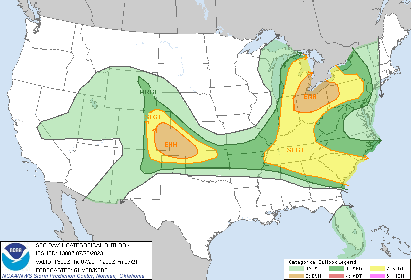 |
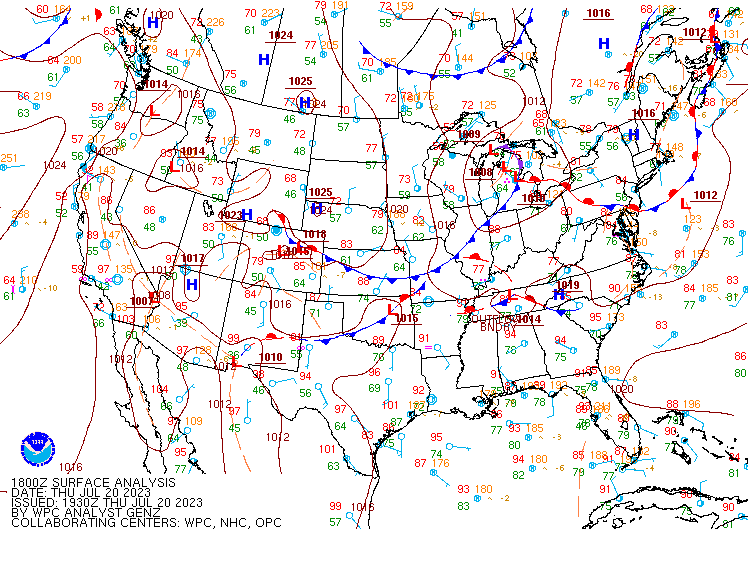
| Figure 1: WPC surface analysis loop from 2 PM to 11 PM EDT on July 20, 2023. | Figure 2: SPC 9 AM convective outlook, outlining a portion of the Lower Great Lakes in an enhanced risk for severe storms (level 3 out of 5). |
Near-storm environment via SPC mesoscale analysis archive page
 |
 |
 |
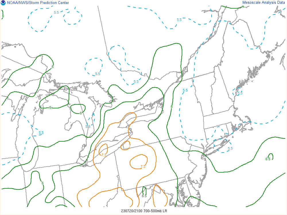 |
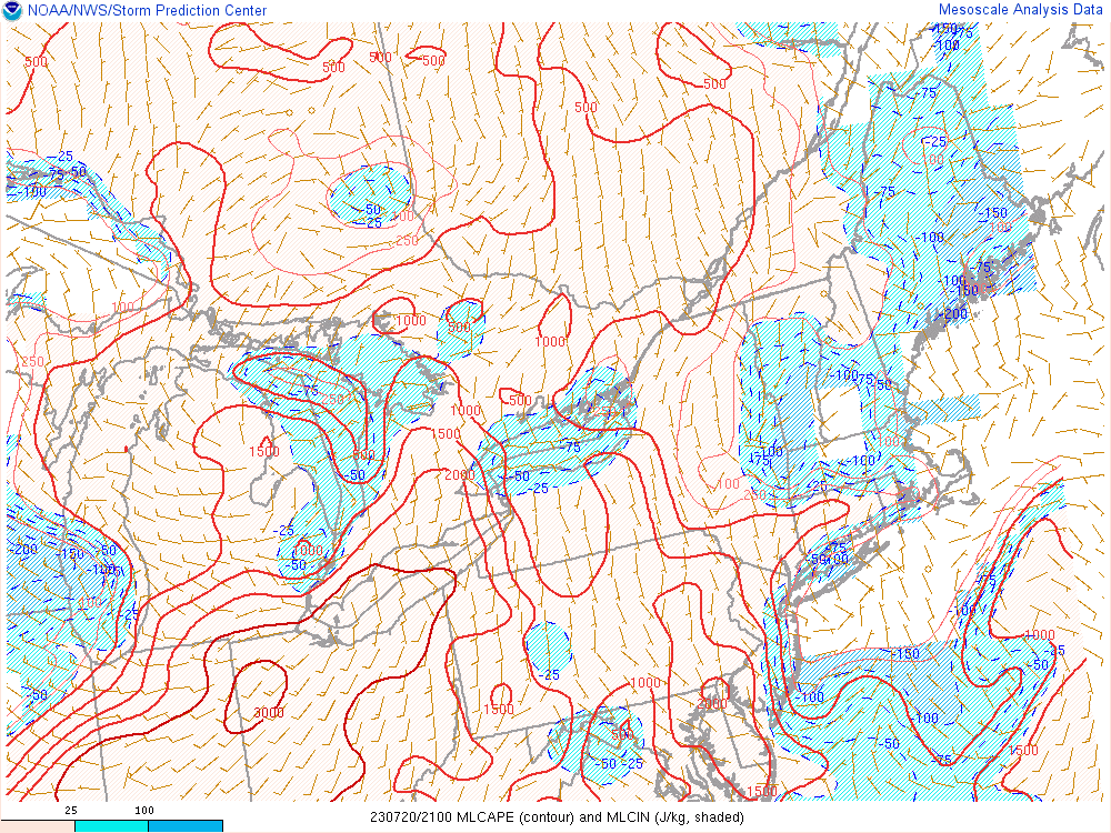
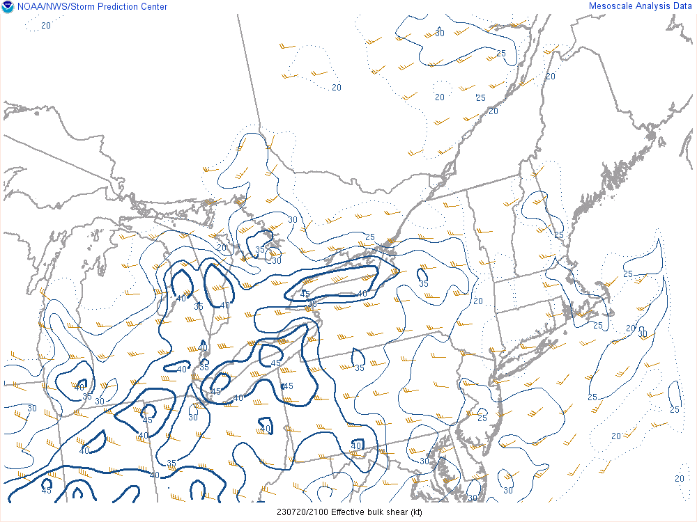
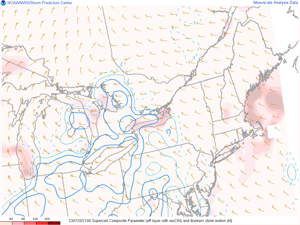
| Figure 3: Mixed-layer CAPE from 5 PM on July 20, 2023. Note the ribbon of moderate to strong instability present (2500 to 3000 J/kg) across the Lower Great Lakes. | Figure 4: Effective bulk shear from 5 PM on July 20, 2023. Values of 35 to 40 knots were observed, which is supportive of organized severe weather. | Figure 5: Supercell composite parameter (SCP) from 5 PM on July 20, 2023. SCP combines several different variables including instability and shear. | Figure 6: Mid-level lapse rates from 5 PM on July 20, 2023. Values of 6.5 to 7.5 C/km, which supports strong instability and thus strong updrafts in storms. Mid-level lapse rates this high for the area is uncommon. |
 |
Media use of NWS Web News Stories is encouraged! Please acknowledge the NWS as the source of any news information accessed from this site. |
|

