Overview
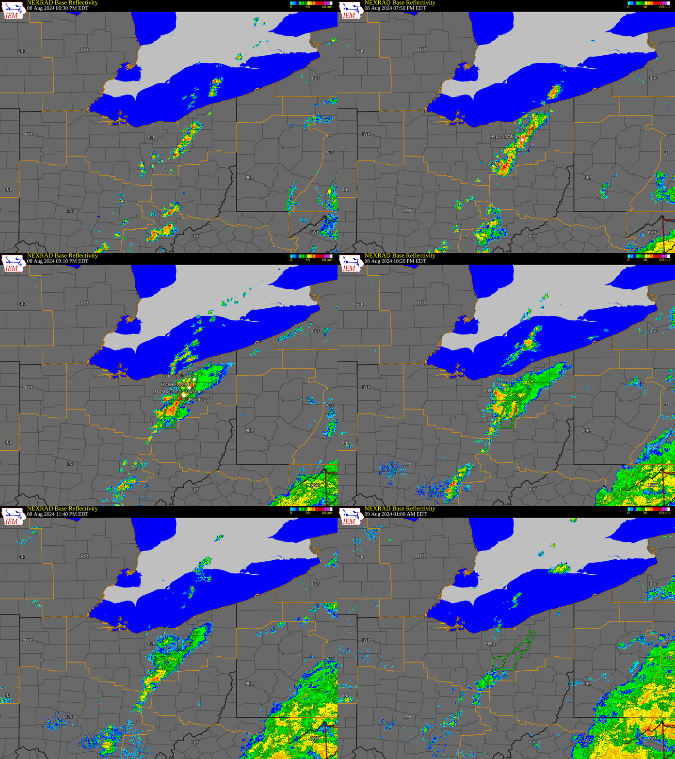
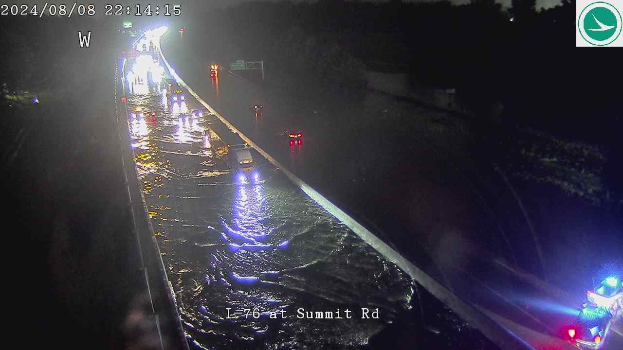
Moisture associated with Tropical Storm Debby and a stationary surface trough resulted in torrential rainfall and flash flooding across portions of Wayne, Summit, Portage, and Geauga Counties in the evening hours of August 8, 2024. Rainfall totals generally totaled between 3 and 5 inches, although isolated pockets as high as 5 to 7 inches were noted around Orrville, Akron/Cuyahoga Falls, and Hudson/Twinsburg. At one point, Interstate 76 in Barberton was closed due to flooding with multiple cars stranded, and there were reports of at least two-dozen water rescues in the Cuyahoga Falls and Akron area in central Summit County. Orrville in eastern Wayne County was especially hard hit, with numerous basements flooded and reports of water rescues. Overall, flooding was reported in a number of communities including Bainbridge in Geauga County, Reminderville, Twinsburg, Hudson, Akron, Cuyahoga Falls, and Barberton in Summit County, and Orrville and Wooster in Wayne County. Hundreds if not thousands of basements were reported to flood in Summit County.
Flooding & Radar
 |
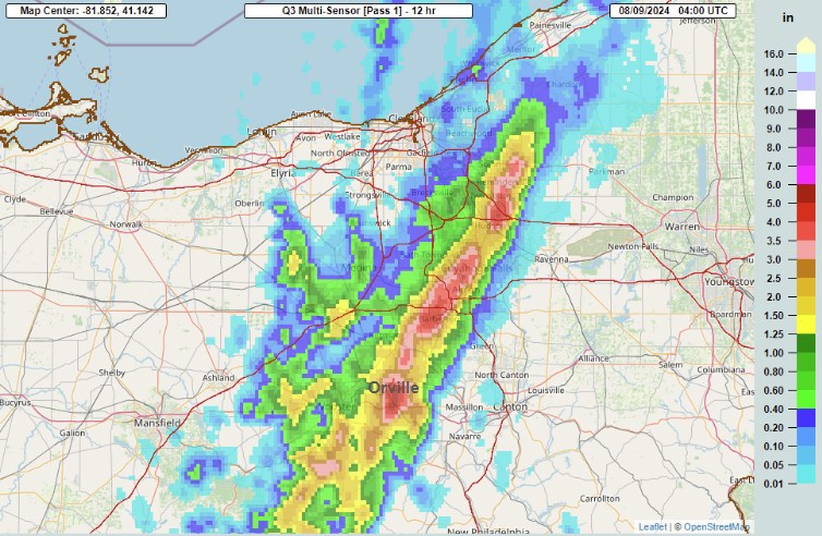 |
| Radar loop from 630 PM on August 8, 2024 to 1 AM on August 9, 2024. | MRMS estimated rainfall totals on August 8, 2024. Note the narrow swath of 3 to 5 inches with isolated higher amounts of 5 to 7 inches. |
.gif) |
 |
 |
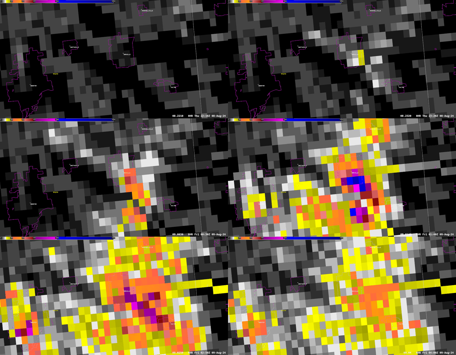 |
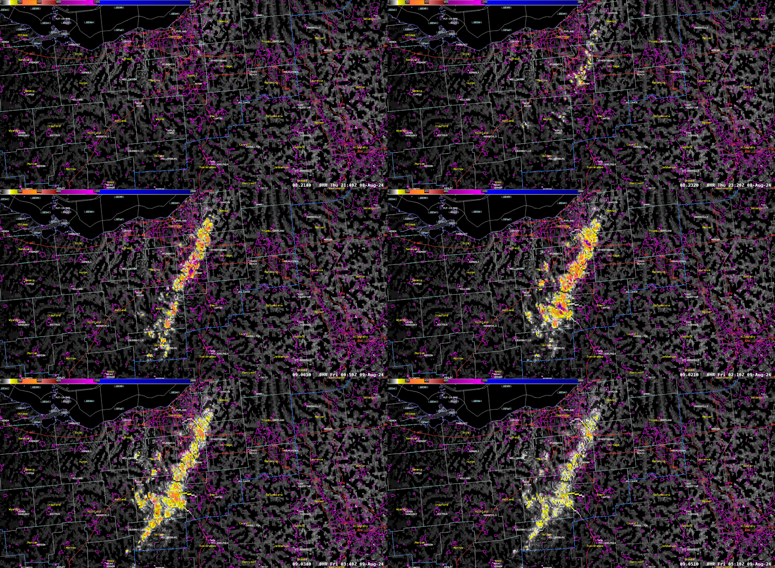
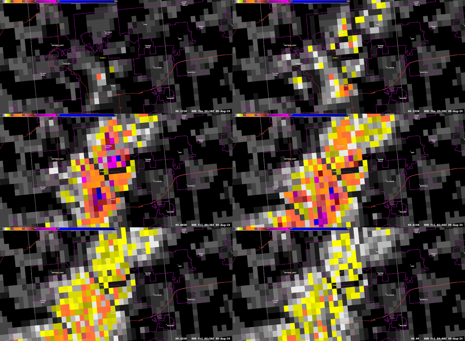
| Loop of 6-hourly radar estimated rainfall, hourly from 2 PM to 11 PM (18:00z to 3:00z) courtesy MRMS. Note the quick increase that occurs in the 7 PM to 10 PM timeframe (23:00-2:00z). Yellows indicate totals over 2", reds over 4", and dark reds and pinks over 6". The highest totals of 5-7" occurred near Orrville, Akron/Cuyahoga Falls, and Twinsburg/Hudson. | Loop of "CREST Unit Streamflow" via MRMS, which is an estimate of excess over-land flow of water based on radar-estimated rainfall amounts. Yellows indicate when nuisance flooding becomes possible in urban areas, with oranges and reds indicating a level more supportive of flash flooding. Purples and blues suggest significant, life threatening flash flooding. Note the significant increases that begin around 8 PM (0:00z). | CREST Unit Streamflow loop zoomed in on the Akron/Cuyahoga Falls area. Note how values begin quickly increasing around 8 PM, peak 8-10 PM, and begin subsiding towards the end of the loop at midnight. This shows how quickly flash flooding can evolve, especially in urban areas. The areas of purple and blue correspond to numerous reports of significant flooding and water rescues. | CREST Unit Streamflow loop zoomed in on the Orrville area. Note how values begin quickly increasing around 8 PM but then quickly increase between 9-10 PM, when the bulk of the flooding impacts likely began developing. The purples and blues correspond to significant excess flow of water over land and indicate potential for significant flash flooding as was observed in the Orrville area. |
Photos & Video
 |
 |
 |
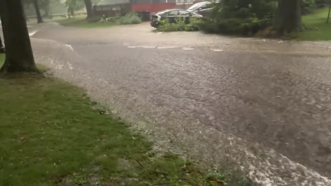 |
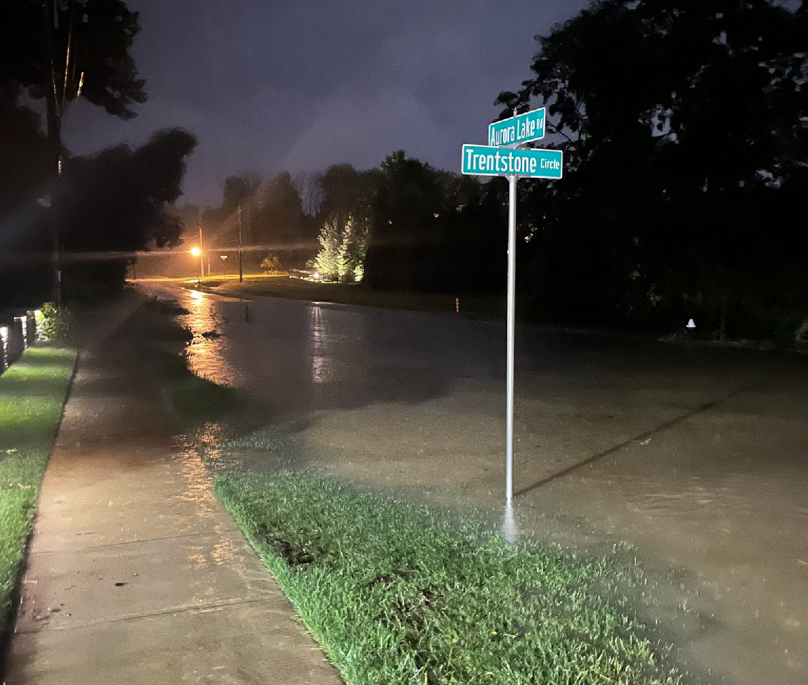
| Flash flooded closed I-76 near Barberton, with multiple cars stuck in the flood waters. Courtesy ODOT. | Flooding along route 306 at US 422 in Bainbridge. Courtesy of @MWC_weather/X | Flash flooding along Aurora Lake Road in Aurora. Courtesy NWS Employee. | Fast-moving water flowing down a street in Akron. Significant flash flooding resulted in lower elevations due to all of this run-off. Courtesy Spencer Willem via X. |
Rainfall Reports
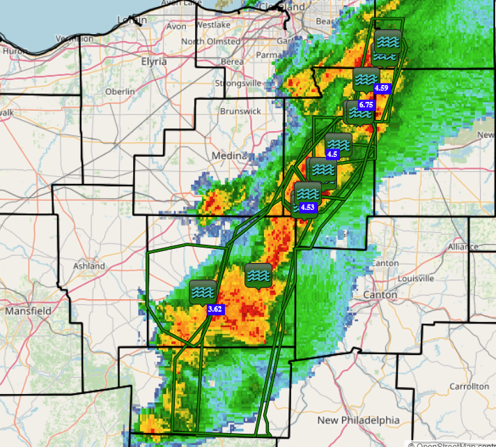 |
| LSR Map on August 8, 2024, showing the radar at 9 PM in addition to the heavy rain and flash flooding reports. |
783
NOUS41 KCLE 091530
PNSCLE
OHZ003-006>014-017>023-027>033-036>038-047-089-PAZ001>003-100330-

Public Information Statement
National Weather Service Cleveland OH
1130 AM EDT Fri Aug 9 2024

...RAINFALL REPORTS FROM AUGUST 8TH 2024...

Location                     Amount    Time/Date       Provider

...Ohio...

...Holmes County...
Millersburg                  2.20 in   1100 AM 08/09   CWOP

...Portage County...
Aurora                       4.65 in   1115 AM 08/09   CWOP

...Summit County...
Hudson                       6.98 in   1115 AM 08/09   CWOP
Reminderville 0.3 NNE        5.25 in   0700 AM 08/09   COCORAHS
Cuyahoga Falls 1.1 ESE       4.86 in   0700 AM 08/09   COCORAHS
Barberton                    4.76 in   1120 AM 08/09   AWS
2 S Cuyahoga Falls           4.50 in   0800 PM 08/08   Trained Spotter
TWINSBURG                    4.04 in   1115 AM 08/09   CWOP
Fairlawn                     2.22 in   1120 AM 08/09   AWS

...Wayne County...
4.4 SE Wooster  (R4)  (R4)   5.62 in   1035 AM 08/09   HADS
Doylestown 2.0 ESE           2.56 in   0753 AM 08/09   COCORAHS
Apple Creek 2.3 NE           2.45 in   0700 AM 08/09   COCORAHS
&&

**METADATA**
:8/09/2024,1100 AM, OH, Holmes, Millersburg, , , 40.5694, -81.9113, RAIN_24, 2.2, Inch, CWOP, 24 hour rainfall,
:8/09/2024,1115 AM, OH, Portage, Aurora, , , 41.297, -81.3693, RAIN_24, 4.65, Inch, CWOP, 24 hour rainfall,
:8/09/2024,1120 AM, OH, Summit, Fairlawn, , , 41.1233, -81.6036, RAIN_24, 2.22, Inch, AWS, 24 hour rainfall,
:8/09/2024,1115 AM, OH, Summit, TWINSBURG, , , 41.3428, -81.4417, RAIN_24, 4.04, Inch, CWOP, 24 hour rainfall,
:8/08/2024,0800 PM, OH, Summit, 2 S Cuyahoga Falls, , , 41.137, -81.5252, RAIN, 4.5, Inch, Trained Spotter, Storm total rainfall,
:8/09/2024,1120 AM, OH, Summit, Barberton, , , 41.0133, -81.6111, RAIN_24, 4.76, Inch, AWS, 24 hour rainfall,
:8/09/2024,0700 AM, OH, Summit, Cuyahoga Falls 1.1 ESE, , , 41.1623, -81.5037, RAIN_24, 4.86, Inch, COCORAHS, 24 hour rainfall,
:8/09/2024,0700 AM, OH, Summit, Reminderville 0.3 NNE, , , 41.3307, -81.395, RAIN_24, 5.25, Inch, COCORAHS, 24 hour rainfall,
:8/09/2024,1115 AM, OH, Summit, Hudson, , , 41.2583, -81.4203, RAIN_24, 6.98, Inch, CWOP, 24 hour rainfall,
:8/09/2024,0700 AM, OH, Wayne, Apple Creek 2.3 NE, , , 40.7719, -81.8025, RAIN_24, 2.45, Inch, COCORAHS, 24 hour rainfall,
:8/09/2024,0753 AM, OH, Wayne, Doylestown 2.0 ESE, , , 40.9575, -81.6624, RAIN_24, 2.56, Inch, COCORAHS, 24 hour rainfall,
:8/09/2024,1035 AM, OH, Wayne, 4.4 SE Wooster  (R4)  (R4)  (R4)  (R4)  (R4)  (R4)  (R4)  (R4)  (R4)  (R4)  (R4)  (R4)  (R4)  (R4)  (R4)  (R4)  (R4)  (R4)  (R4)  (R4)  (R4)  (R4)  (R4)  (R4)  (R4)  (R4)  (R4)  (R4)  (R4)  (R4)  (R4)  (R4)  (R4)  (R4)  (R4)  (R4)  (R4)  (R4)  (R4)  (R4)  (R4)  (R4)  (R4)  (R4)  (R4)  (R4)  (R4)  (R4)  (R4)  (R4)  (R4)  (R4)  (R4)  (R4)  (R4)  (R4)  (R4)  (R4)  (R4)  (R4)  (R4)  (R4)  (R4)  (R4)  (R4)  (R4)  (R4)  (R4)  (R4)  (R4)  (R4)  (R4)  (R4)  (R4)  (R4)  (R4)  (R4)  (R4)  (R4)  (R4)  (R4), , , 40.7583, -81.9061, RAIN_24, 5.62, Inch, HADS, 24 hour rainfall,

Observations are collected from a variety of sources with varying
equipment and exposures. We thank all volunteer weather observers
for their dedication. Not all data listed are considered official.

$$
 |
Media use of NWS Web News Stories is encouraged! Please acknowledge the NWS as the source of any news information accessed from this site. |
 |