Overview
|
During the late afternoon and evening hours on March 14, 2024, scattered thunderstorms moved west to east across much of the area ahead of a low pressure and cold front. A favorable combination of strong wind shear (winds increasing in speed and changing direction with height) and instability allowed a few of these thunderstorms to evolve into persistent, rotating supercells. Supercells are known to be the most prolific type of thunderstorm when it comes to producing large hail and longer-tracked, more intense tornadoes. We issued several tornado warnings across our forecast area and have confirmed two damage-producing tornadoes, including an EF-2 tornado in parts of Crawford and Richland Counties. Very large hail up to 3" in diameter (larger than a baseball!) was also observed in Seneca County. |
.gif) Radar loop, watches, warnings, and local storm reports from March 14, 2024. |
Tornadoes:
|
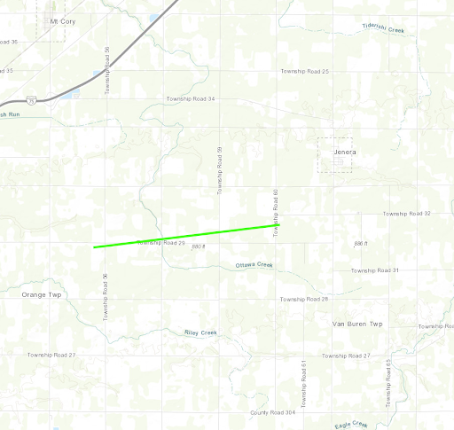
Tornado - Southwest of Jenera
|
||||||||||||||||
|
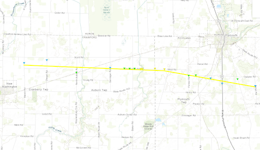
Tornado - New Washington-Plymouth
|
||||||||||||||||
|
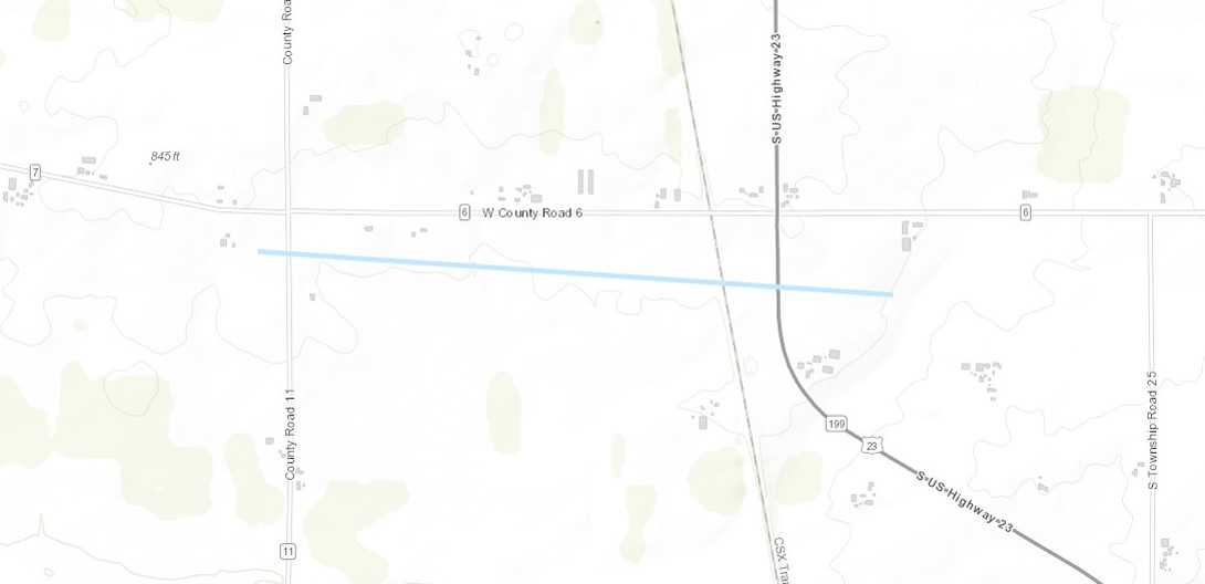
Tornado - Southeast of Biglick Township
|
||||||||||||||||
The Enhanced Fujita (EF) Scale classifies tornadoes into the following categories:
| EF0 Weak 65-85 mph |
EF1 Moderate 86-110 mph |
EF2 Significant 111-135 mph |
EF3 Severe 136-165 mph |
EF4 Extreme 166-200 mph |
EF5 Catastrophic 200+ mph |
 |
|||||
Hail:
Several instances of large hail were reported across parts of Northwest and North Central Ohio from these thunderstorms. Particularly large hail occurred across parts of southern Seneca and Huron Counties. Hail up to 3" in diameter was reported in Seneca County!
 |
 |
| Very large hail in Bloomville, OH. Courtesy Christal McCoy. | Huge hail (measured larger than 3") in Bloomville, OH. Courtesy Melody Schirack. |
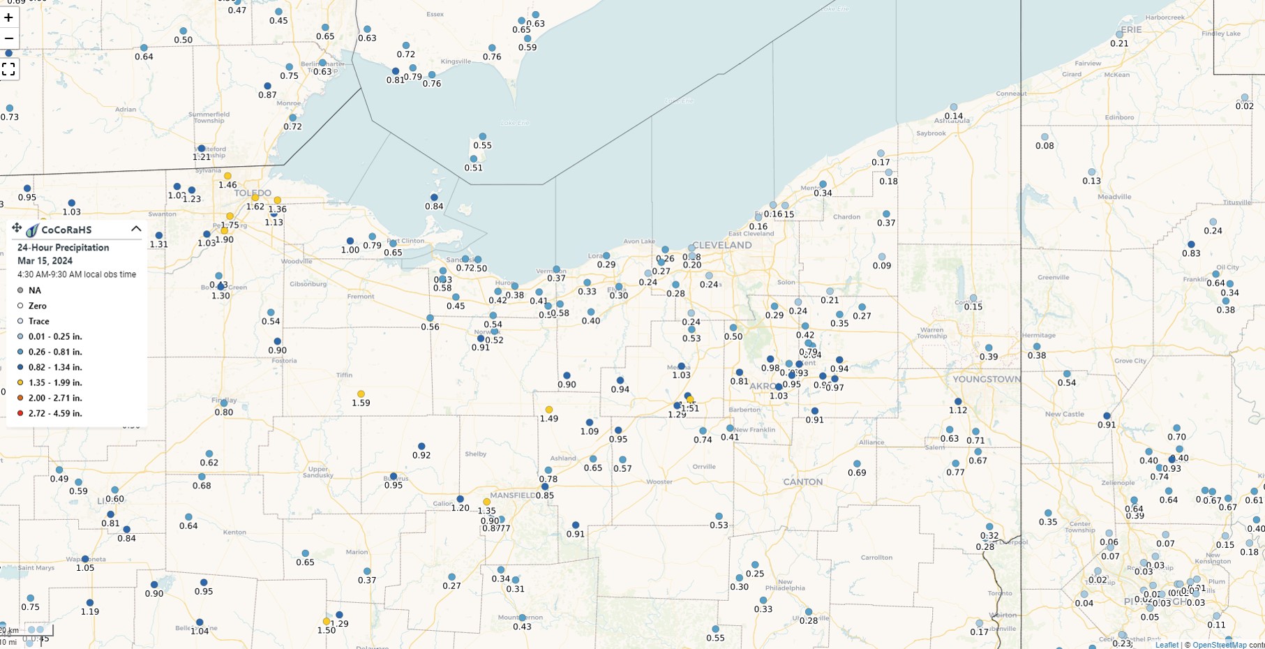
Flooding
Repeated thunderstorms tracked across parts of northern Ohio during the evening hours of March 14th, leading to locally heavy rainfall. At least some localized flooding was observed across parts of Seneca, Huron, Medina, Richland and Ashland Counties. The most impactful flooding occurred across southern Huron County.
Radar/Photos
 |
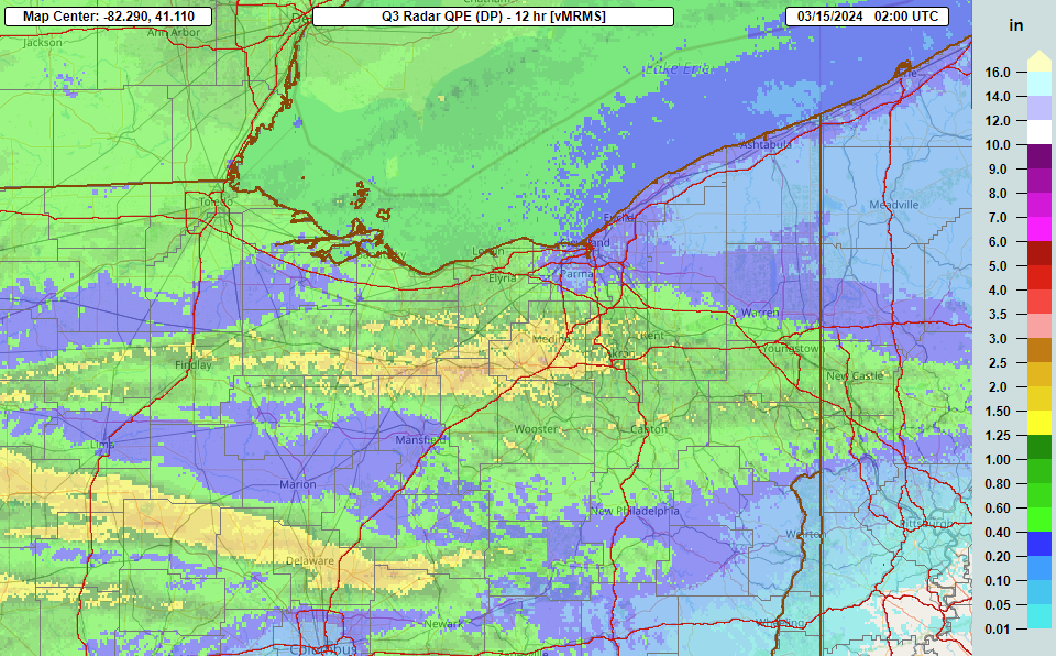 |
| Rainfall totals from CoCoRaHS observers. Click here for a more detailed report. | Radar-estimated rainfall amounts from Multi-Radar/Multi-Sensor System (MRMS). More details on MRMS. |
Photos & Video
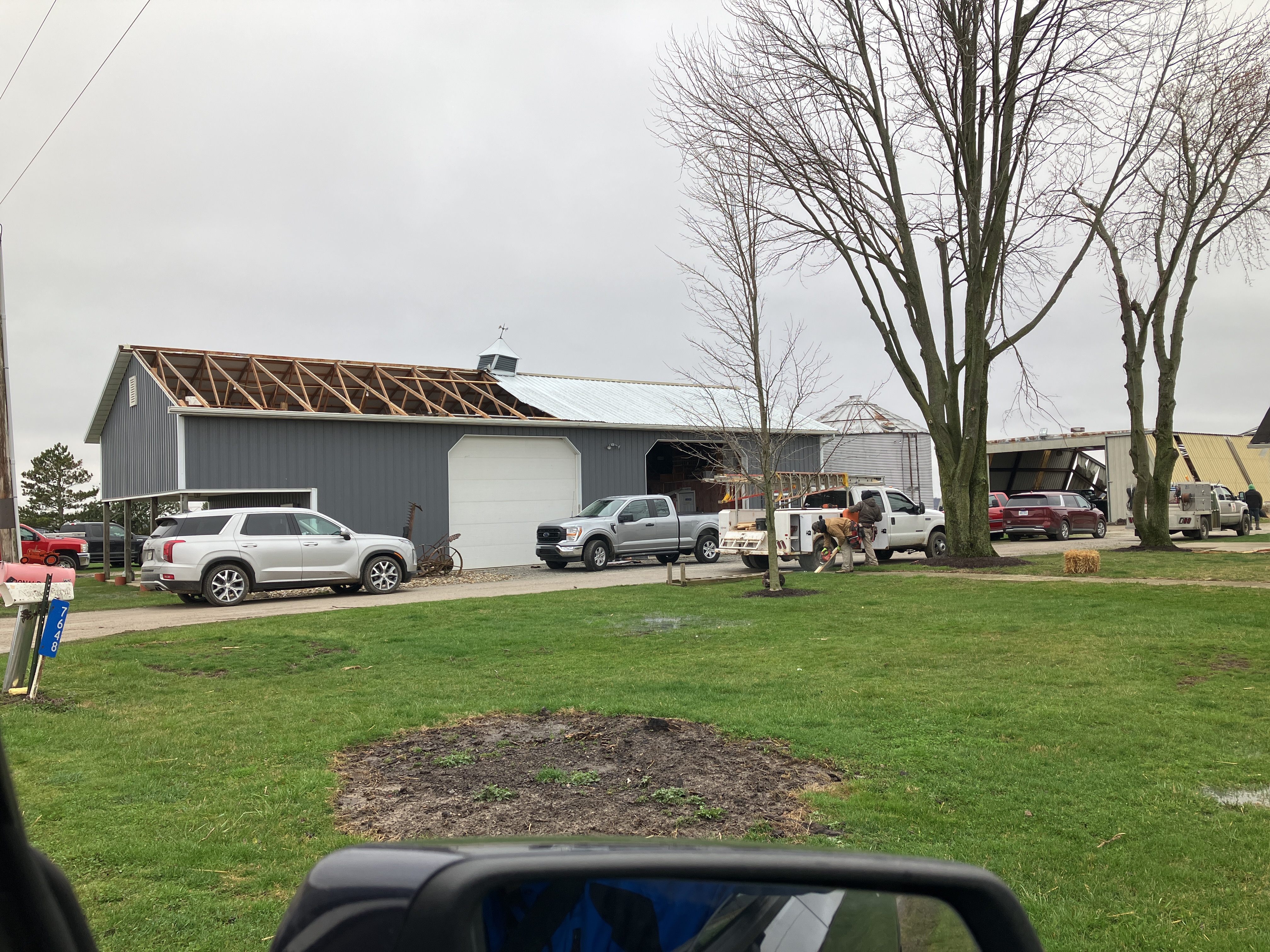
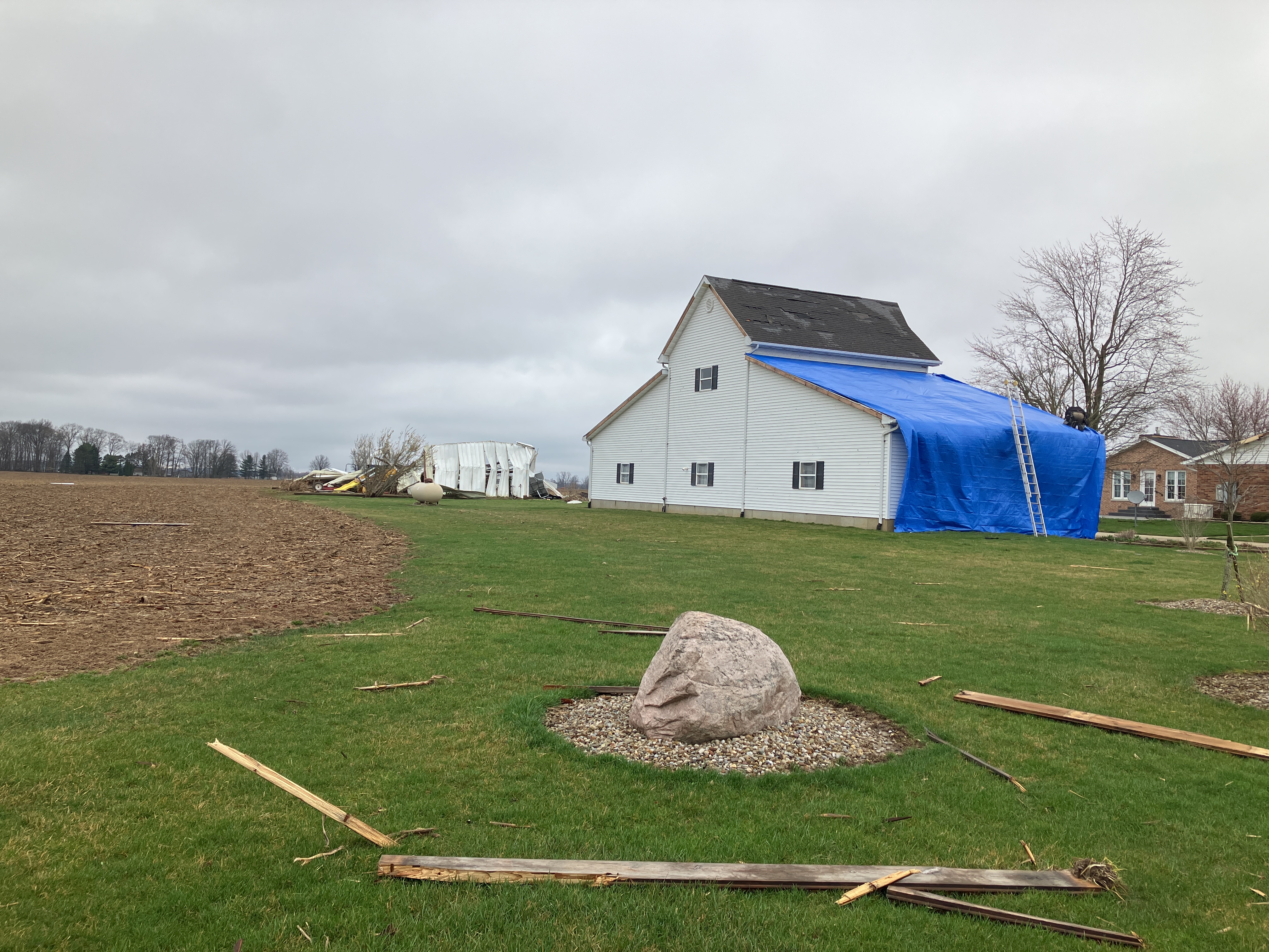
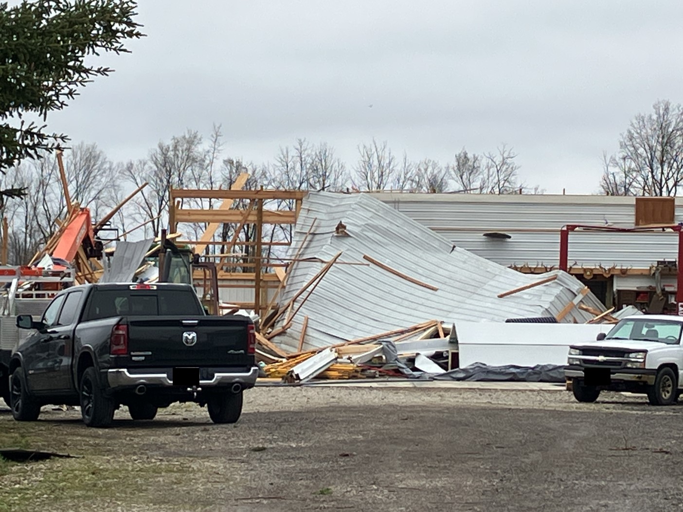
New Washington-Plymouth Tornado Damage
 |
 |
 |
 |
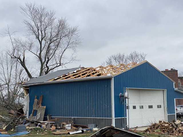
| Damage to a garage in Plymouth Township, OH. (NWS Storm Survey) |
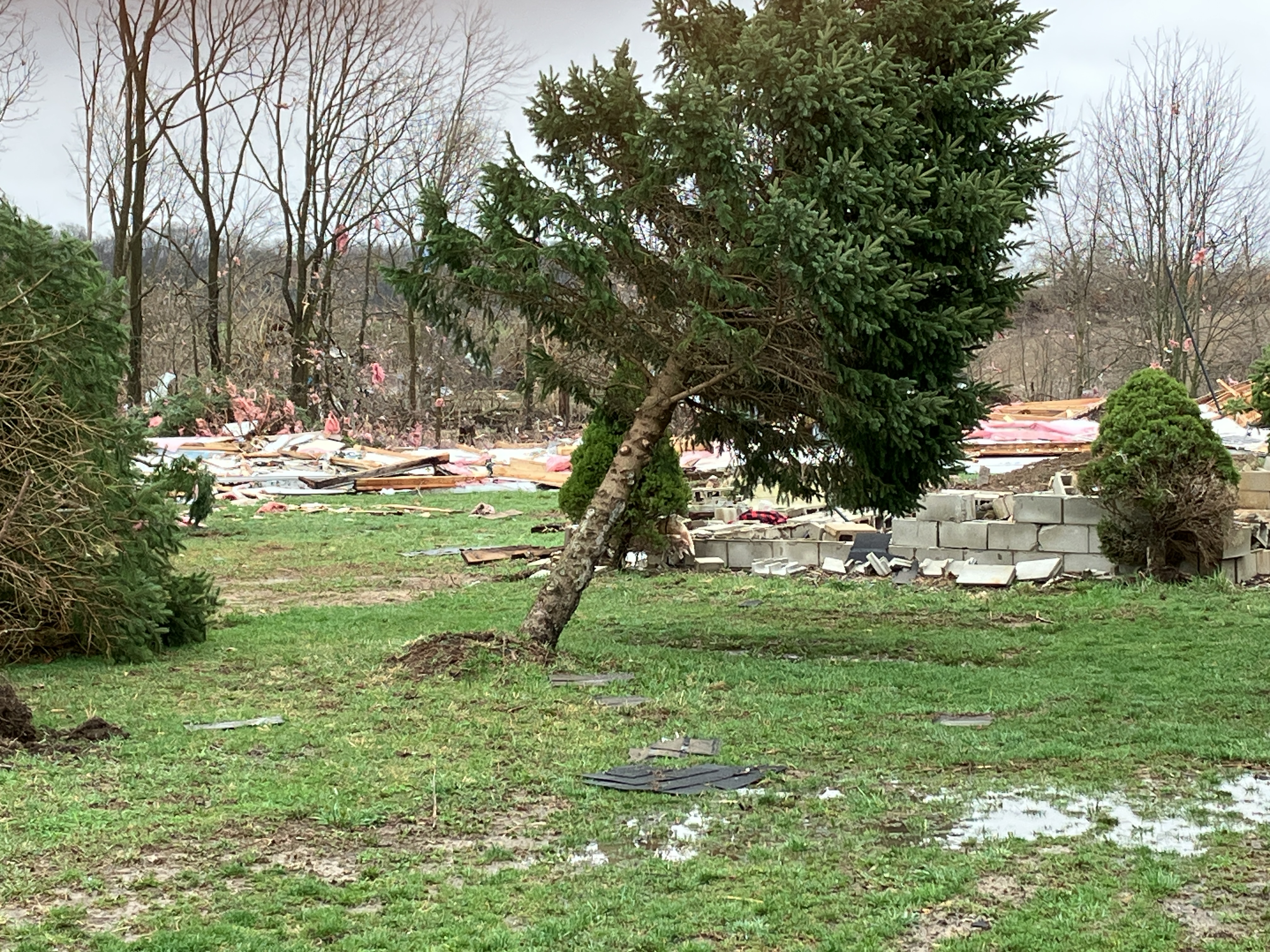
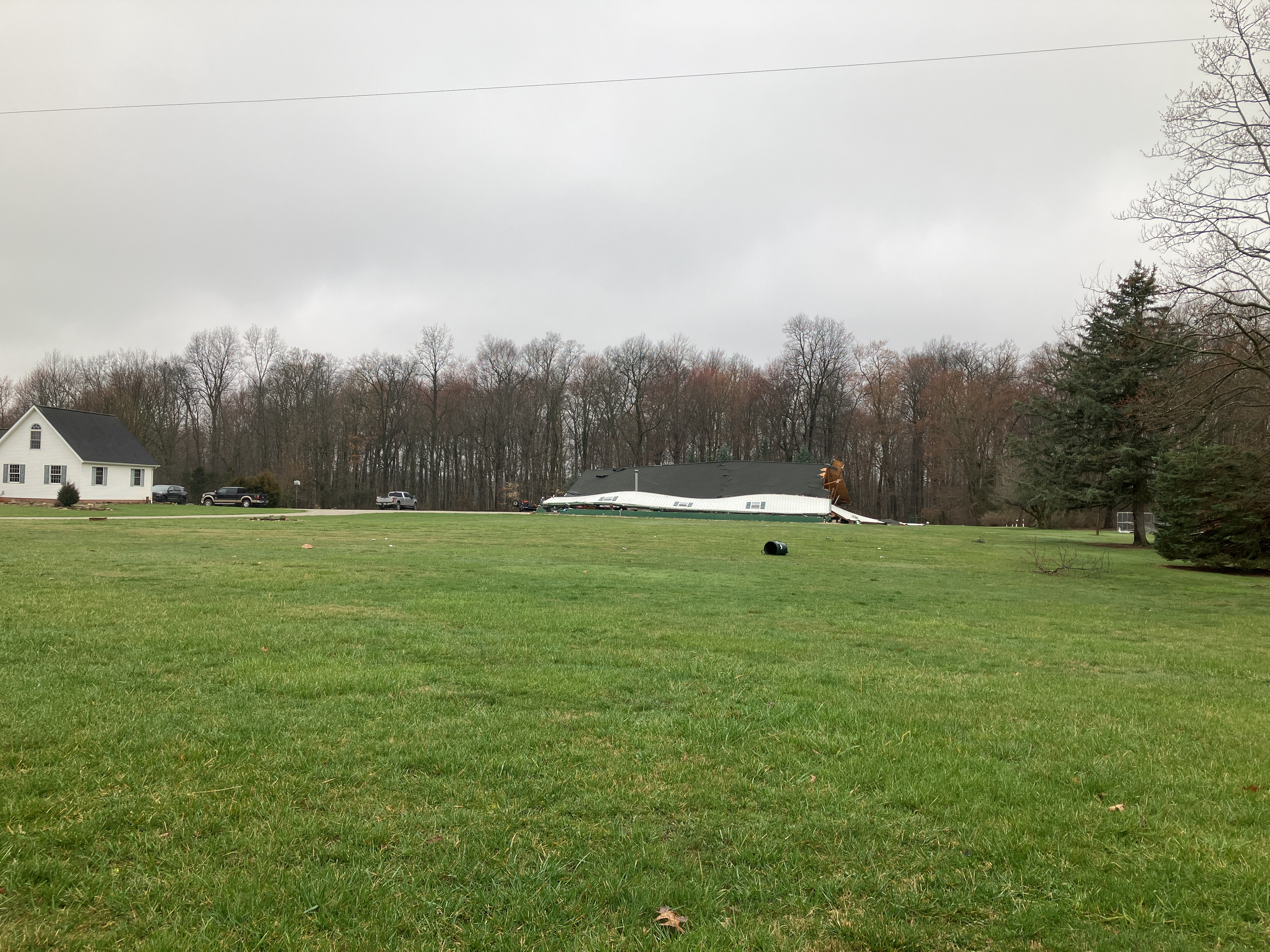
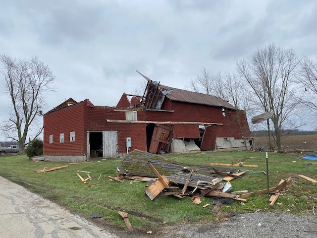
Damage to roofing of a house and outbuilding in Auburn Township, OH with debris littering the yard. (NWS Storm Survey) |
Complete destruction of a farm structure in Auburn Township, OH. (NWS Storm Survey) |
Remnants of a manufactured home in Auburn Township, OH. (NWS Storm Survey) |
 |
 |
 |
 |
| Collapsed outbuilding in Auburn Township, OH. (NWS Storm Survey) |
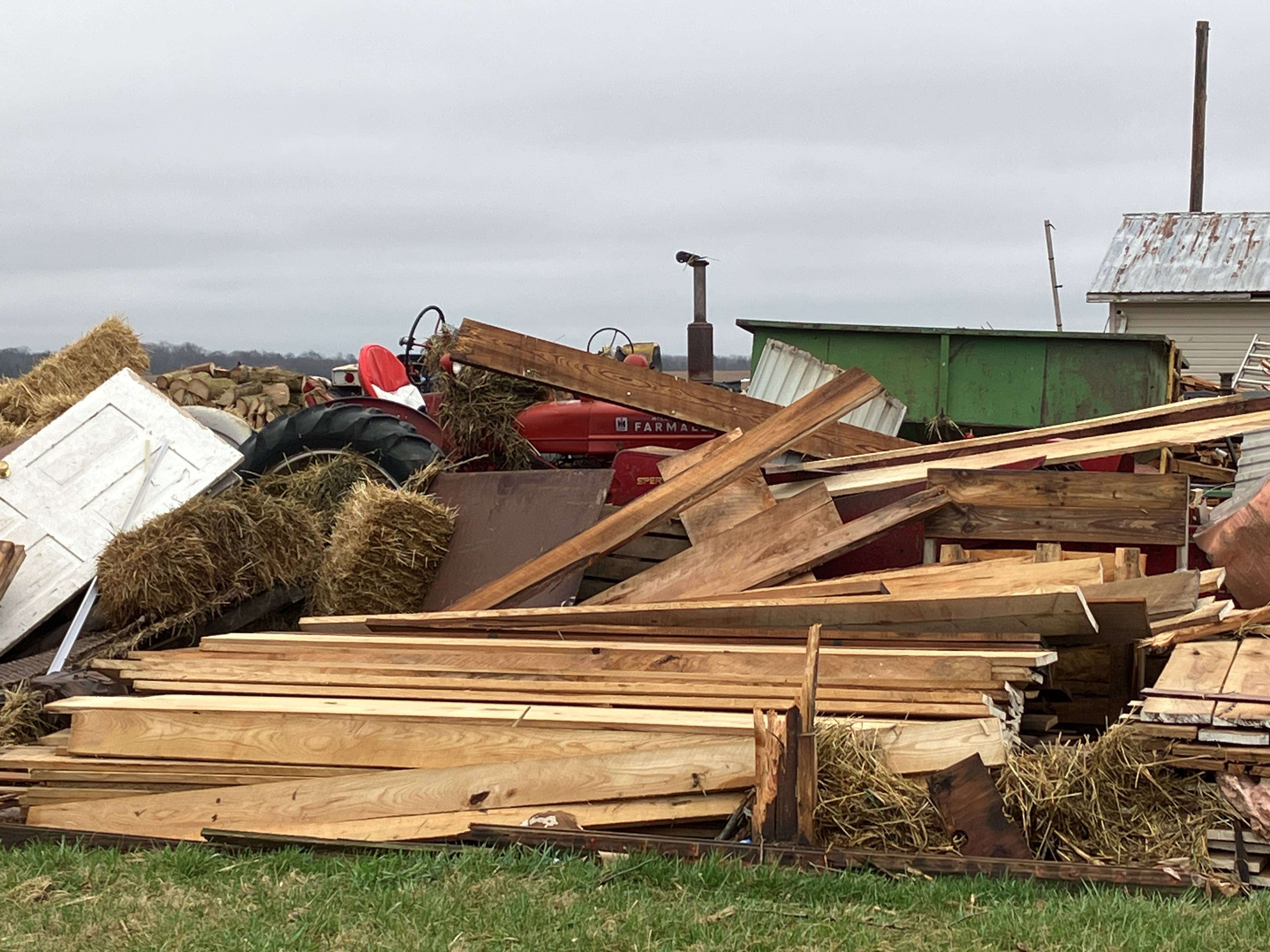
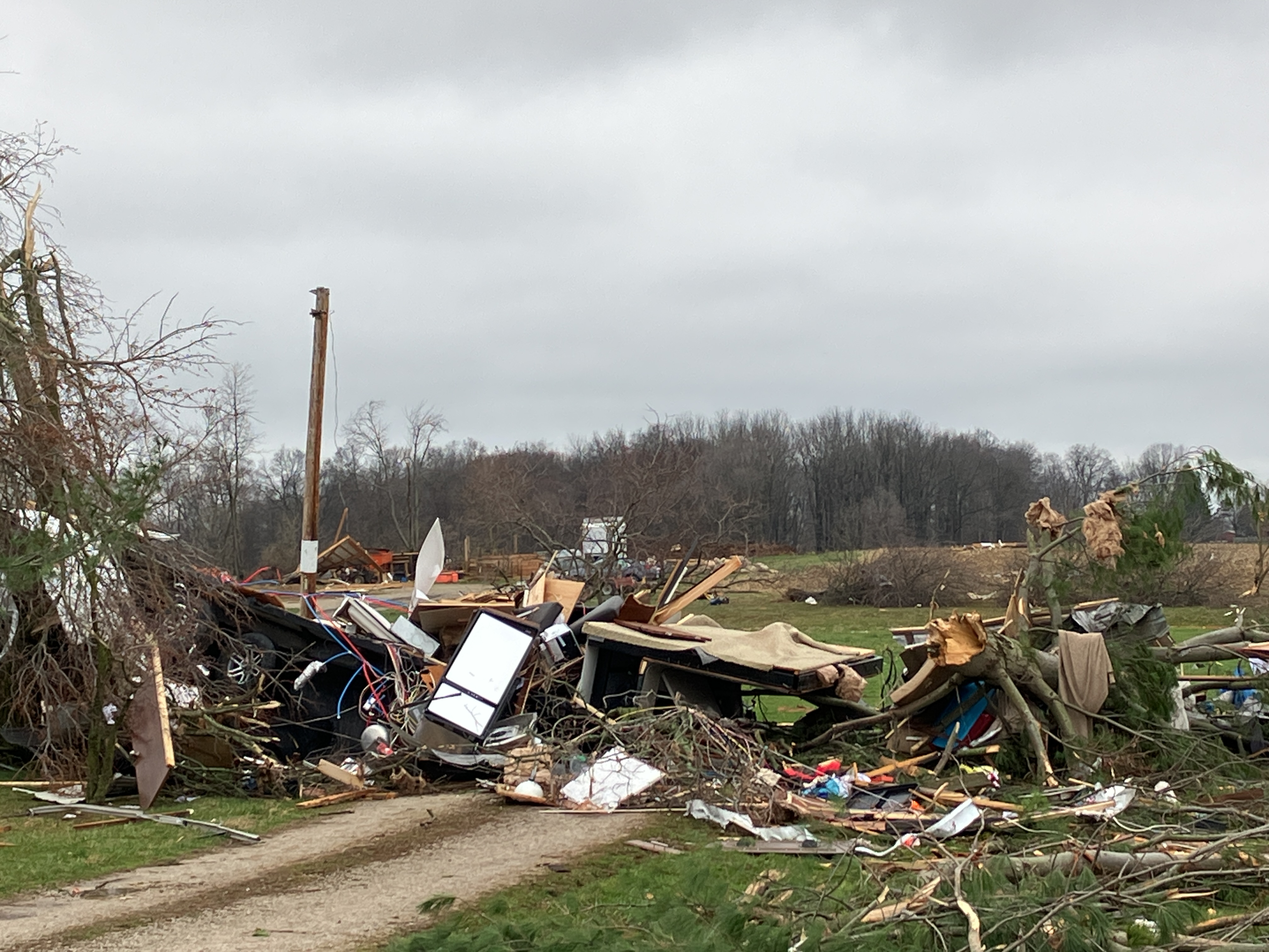
Extensive damage to numerous farm buildings in Auburn Township, OH. (NWS Storm Survey) |
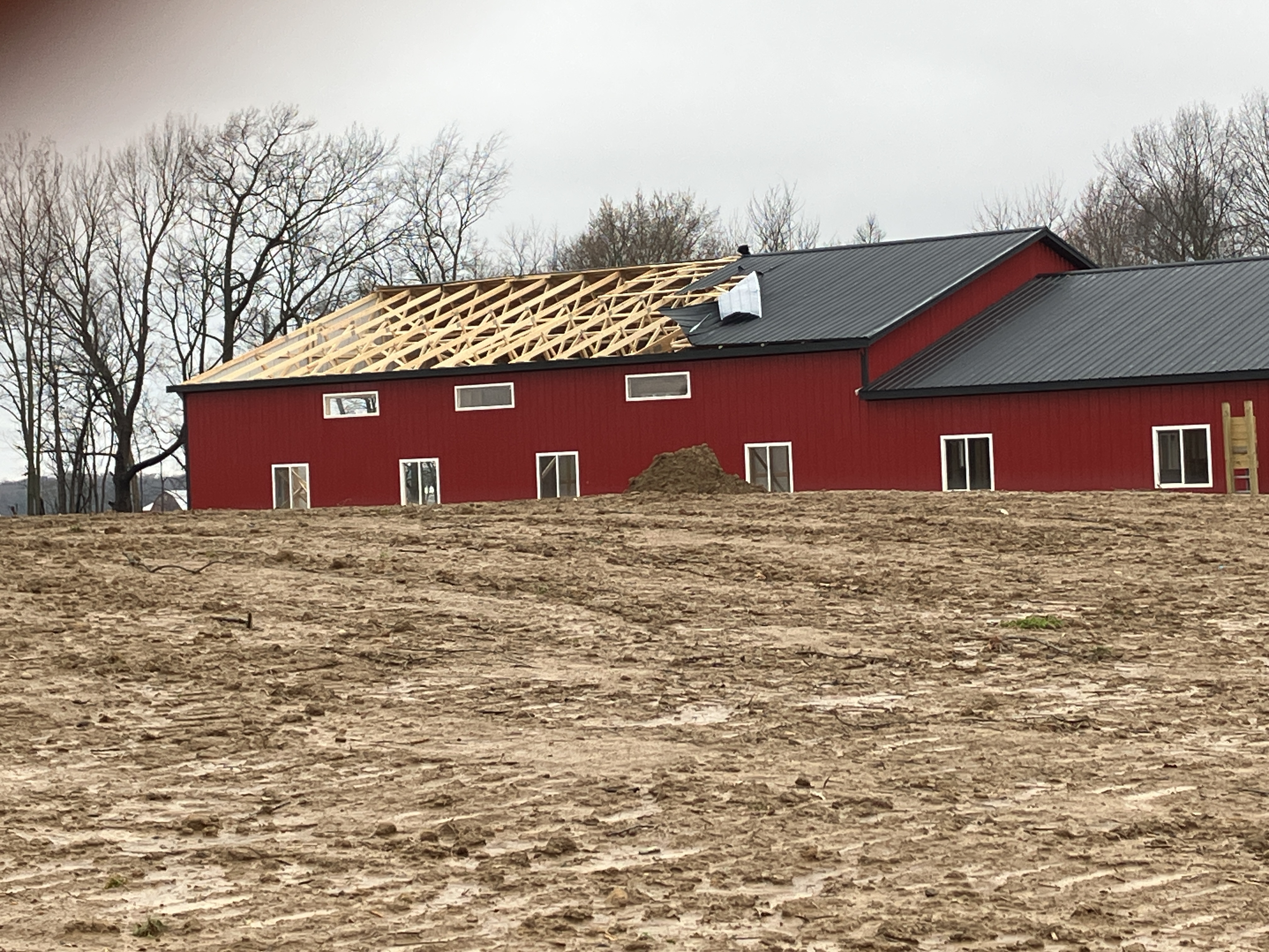
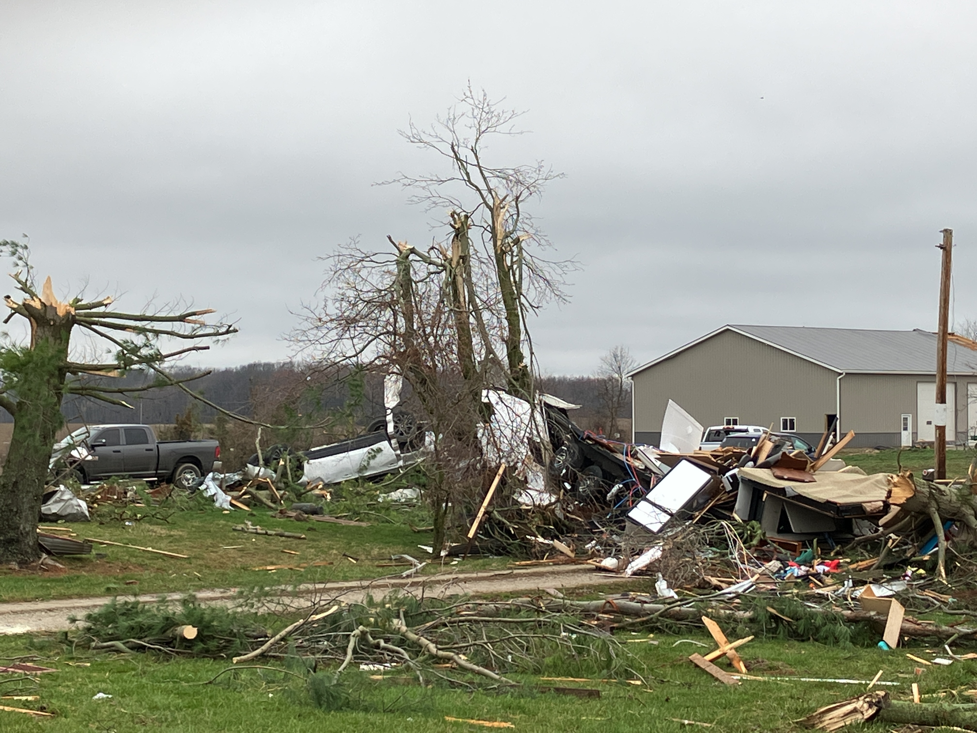
Entire roof destroyed on structure in Plymouth Township, OH. (NWS Storm Survey) |
Entire structure collapsed in Plymouth Township, OH. (NWS Storm Survey) |
 |
 |
 |
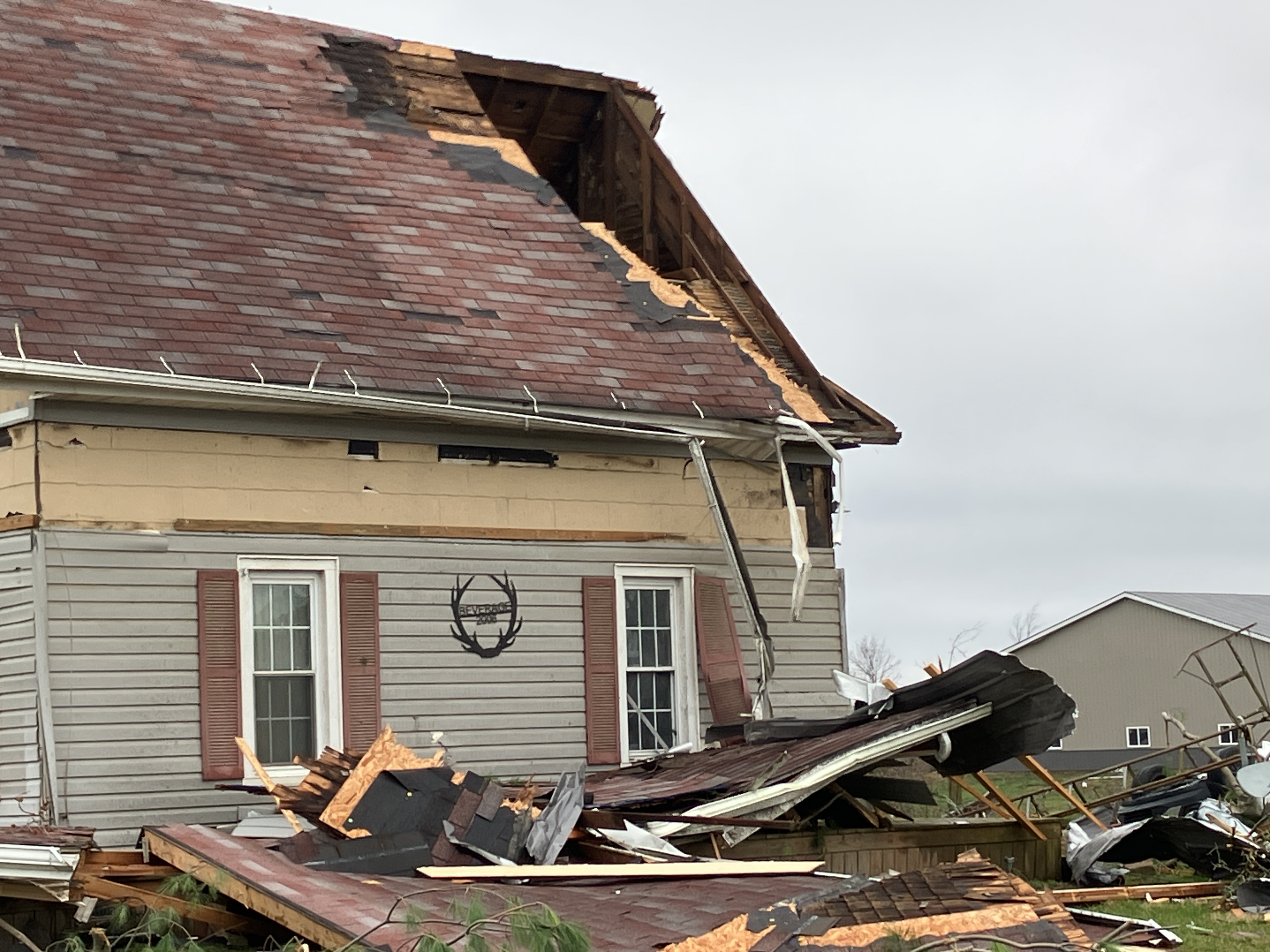
| Significant damage occurred to a home in Plymouth Township, OH. (NWS Storm Survey) |
Significant damage occurred to a home in Plymouth Township, OH, including a flipped vehicle. (NWS Storm Survey) |
Significant damage occurred to a home in Plymouth Township, OH, including a displaced trailer. (NWS Storm Survey) |
Southwest of Jenera Tornado Damage
 |
 |
 |
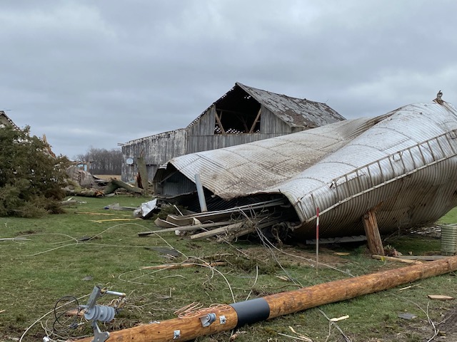 |
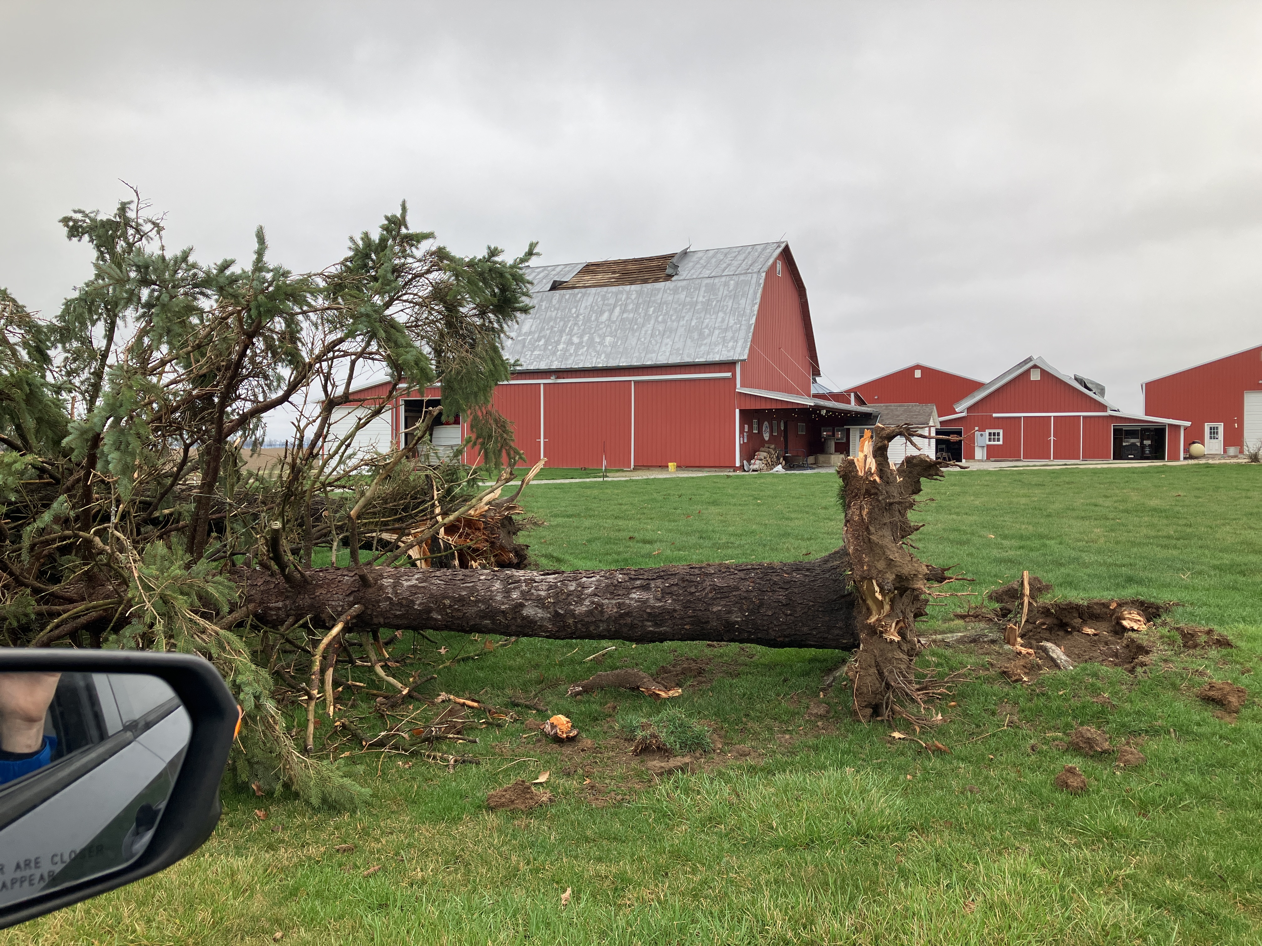
| A brick barn was heavily damaged. (NWS Storm Survey) |
A roof was mostly torn off of an outbuilding. (NWS Storm Survey) |
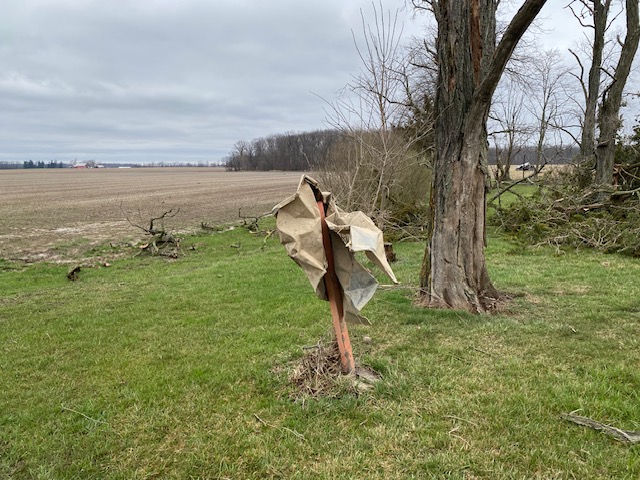
A piece of metal siding or roof wrapped around a wooden post. (NWS Storm Survey) |
Grain bin collapsed. (NWS Storm Survey) |
Radar
 |
 |
 |
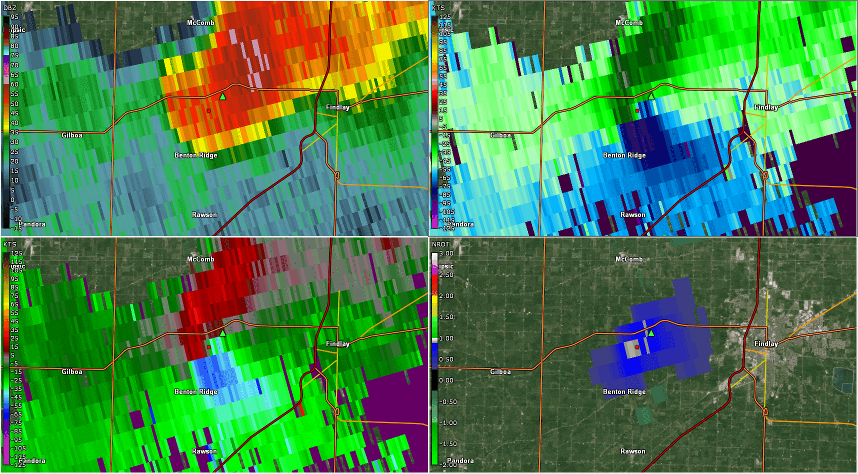 |
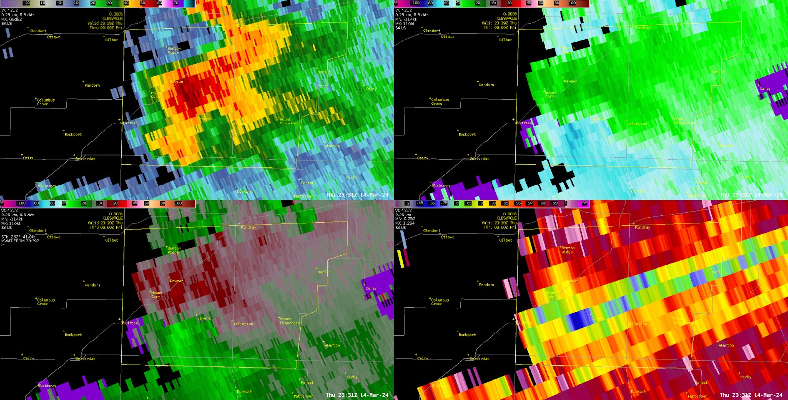
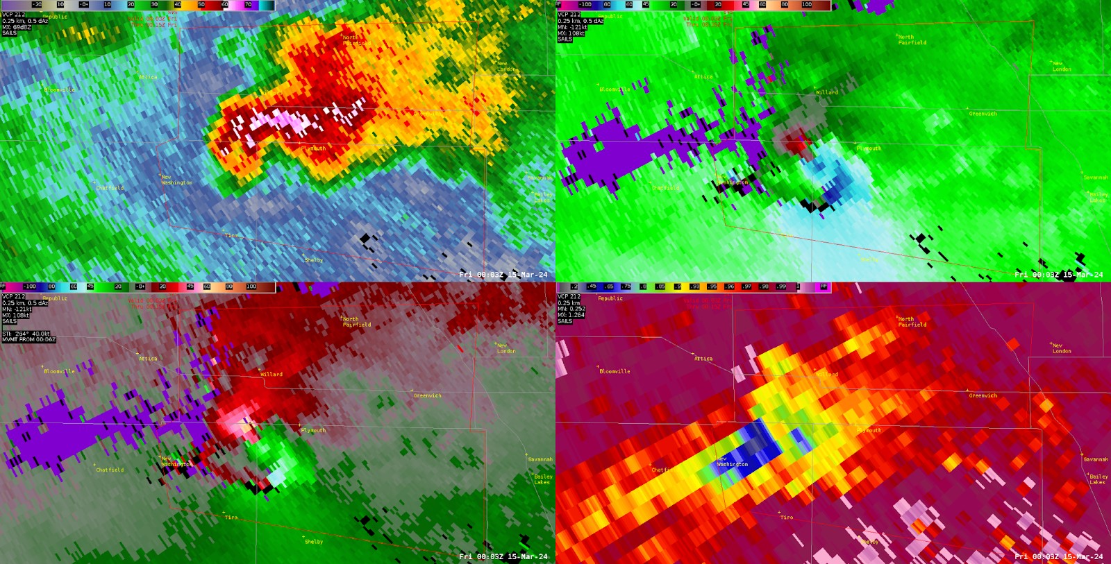
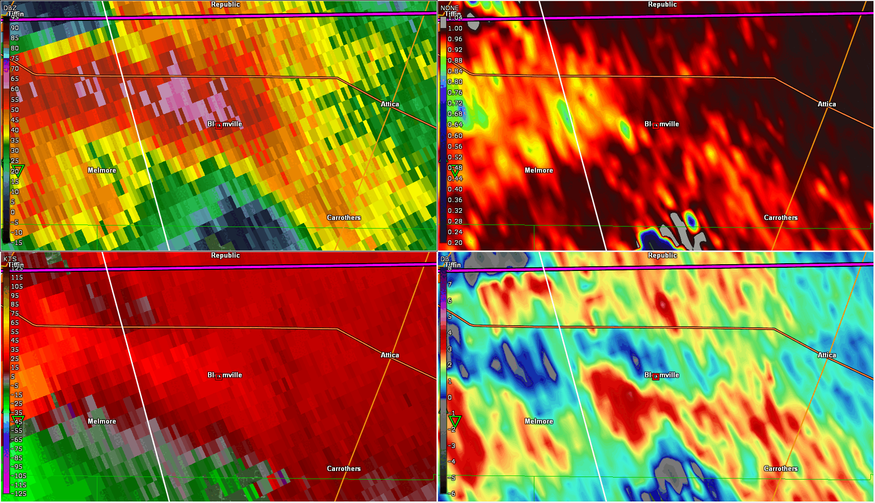
| Radar imagery from the Cleveland WSR-88D of the tornado that occurred near Jenera, OH. Top left: reflectivity, top right: base velocity, bottom left: storm relative velocity, bottom right: correlation coefficient. At this distance, the radar beam is sampling at 10 kft above ground level, and only observed weak rotation in velocity. | Radar imagery from the Cleveland WSR-88D of the tornado that occurred near Plymouth, OH. Top left: reflectivity, top right: base velocity, bottom left: storm relative velocity, bottom right: correlation coefficient. Notable features include a defined "hook" in reflectivity, strong rotation in velocity, and tornado debris signature (TDS; indicative of debris being lofted by a tornado), which is when low correlation coefficient is colocated with strong rotation in velocity. | Radar imagery from the Cleveland WSR-88D of significant hail that fell in Bloomville, OH. Top left: reflectivity, top right: correlation coefficient, bottom left: storm relative velocity, bottom right: differential reflectivity. For large hail, typically there is high reflectivity of > 60 dBZ, low correlation coefficient (often times 0.9 or lower), and near zero or even negative differential reflectivity. For very large hail, there is also usually a strong mesocyclone, indicated by the strong rotation in velocity. | Radar imagery from the Cleveland WSR-88D following the main supercell that produced an EF-2 and large hail up to 3". Top left: reflectivity, top right: base velocity, bottom left: storm relative velocity, bottom right: normalized rotation. Time of radar loop: 6:43-8:38 PM EST |
Storm Reports
..TIME...   ...EVENT...      ...CITY LOCATION...     ...LAT.LON...
..DATE...   ....MAG....      ..COUNTY LOCATION..ST.. ...SOURCE....
            ..REMARKS..

0653 PM     Funnel Cloud     2 W Findlay             41.04N 83.67W
03/14/2024                   Hancock            OH   Trained Spotter

            Funnel cloud observed by trained spotter at
            OH-12 and I-75 before it became
            rain-wrapped.

0703 PM     Tornado          4 NNW Mount Blanchard   40.95N 83.58W
03/14/2024                   Hancock            OH   Law Enforcement

            Law enforcement observed a tornado looking
            north from OH-37 and Township Road 168.

0722 PM     Tstm Wnd Dmg     5 SE New Riegel         40.99N 83.26W
03/14/2024                   Wyandot            OH   Public

            Utility pole down and hit a vehicle.

0725 PM     Funnel Cloud     4 ESE New Riegel        41.02N 83.24W
03/14/2024                   Seneca             OH   Public

            Numerous observations of lowering funnel
            cloud.

0725 PM     Hail             1 WSW Tiffin            41.11N 83.19W
03/14/2024  E1.00 inch       Seneca             OH   Trained Spotter


0730 PM     Tornado          4 SSE Mount Cory        40.88N 83.81W
03/14/2024                   Hancock            OH   NWS Storm Survey

            An EF-1 tornado with maximum estimated winds
            of 100 MPH developed in Orange Township in
            southwestern Hancock County. The tornado
            tracked 3.3 miles towards the east, lifting
            in Van Buren Township. The tornado damaged 5
            homes and damaged or destroyed several farm
            buildings. The maximum width was about 100
            yards.

0730 PM     Tstm Wnd Dmg     3 SW Jenera             40.88N 83.77W
03/14/2024                   Hancock            OH   Emergency Mngr

            Corrects previous tstm wnd dmg report from 3
            SW Jenera. Emergency management reported
            several structures with significant damage,
            including roofs blown off of homes and
            partial collapse of barns along Township
            Road 29. Several large trees down as well.
            Report corrected for time based on radar.

0730 PM     Tstm Wnd Dmg     3 WSW Jenera            40.88N 83.79W
03/14/2024                   Hancock            OH   Emergency Mngr

            Corrects previous tstm wnd dmg report from 3
            WSW Jenera. Report of damage to houses near
            Township Road 29 and Township Road 12.
            Report corrected for time based on radar.

0731 PM     Hail             Rawson                  40.96N 83.78W
03/14/2024  E1.00 inch       Hancock            OH   Public

            Report from mPING: Quarter (1.00 in.).

0732 PM     Hail             Bloomville              41.05N 83.02W
03/14/2024  E2.50 inch       Seneca             OH   Public

            Corrects previous hail report from
            Bloomville. Two to two and a half inch size
            hail. Report corrected for time based on
            radar.

0732 PM     Hail             Bloomville              41.05N 83.02W
03/14/2024  E3.00 inch       Seneca             OH   Amateur Radio

            Corrects previous hail report from
            Bloomville. Two and a half to three inch
            size hail. Report corrected for time based
            on radar.

0754 PM     Tornado          2 NE New Washington     40.98N 82.84W
03/14/2024                   Crawford           OH   NWS Storm Survey

            Tornado began along Marsh Road just
            northeast of New Washington in Crawford
            County and continued east into northern
            Richland County, lifting along Willet Road
            east of Plymouth Township. The peak
            intensity was EF-2 with winds estimated at
            120 MPH in Auburn Township and Plymouth
            Township. The max width was 250 yards. The
            tornado was on the ground for slightly over
            10 miles.

0802 PM     Tstm Wnd Dmg     2 SSW Willard           41.03N 82.73W
03/14/2024                   Huron              OH   Emergency Mngr

            Corrects previous tstm wnd dmg report from 2
            SSW Willard. Utility poles down on State
            Route 103. Report corrected for time based
            on radar.

0803 PM     Hail             3 S Willard             41.00N 82.73W
03/14/2024  E2.00 inch       Huron              OH   Fire Dept/Rescue


0803 PM     Tstm Wnd Dmg     3 WSW Plymouth          40.97N 82.71W
03/14/2024                   Richland           OH   Emergency Mngr

            Corrects previous tstm wnd dmg report from 3
            WSW Plymouth. Trailer in roadway on West
            Road in Plymouth. Emergency management also
            relayed several reports of significant
            damage southwest of Plymouth. Report
            corrected for time based on radar.

0803 PM     Tornado          4 W Plymouth            41.00N 82.74W
03/14/2024                   Huron              OH   Fire Dept/Rescue

            Fire department reported half-mile wide
            tornado crossing State Route 103 near the
            Crawford County OH and Huron County line.
            Report relayed by emergency management.

0803 PM     Tstm Wnd Dmg     2 WSW Plymouth          40.99N 82.71W
03/14/2024                   Richland           OH   Public

            Corrects previous tstm wnd dmg report from 2
            WSW Plymouth. Multiple utility poles down.
            Metal siding or roof also wrapped around
            trees on State Route 598 southwest of
            Plymouth. Report corrected for time based on
            radar.

0804 PM     Hail             1 ENE Attica            41.07N 82.86W
03/14/2024  E2.00 inch       Seneca             OH   Fire Dept/Rescue

            At least 2 inch hail reported in Attica
            area. Report relayed by emergency
            management.
Environment
Synoptic Scale Environment
 |
 |
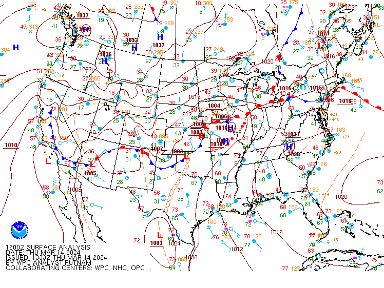 |
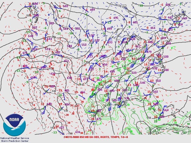
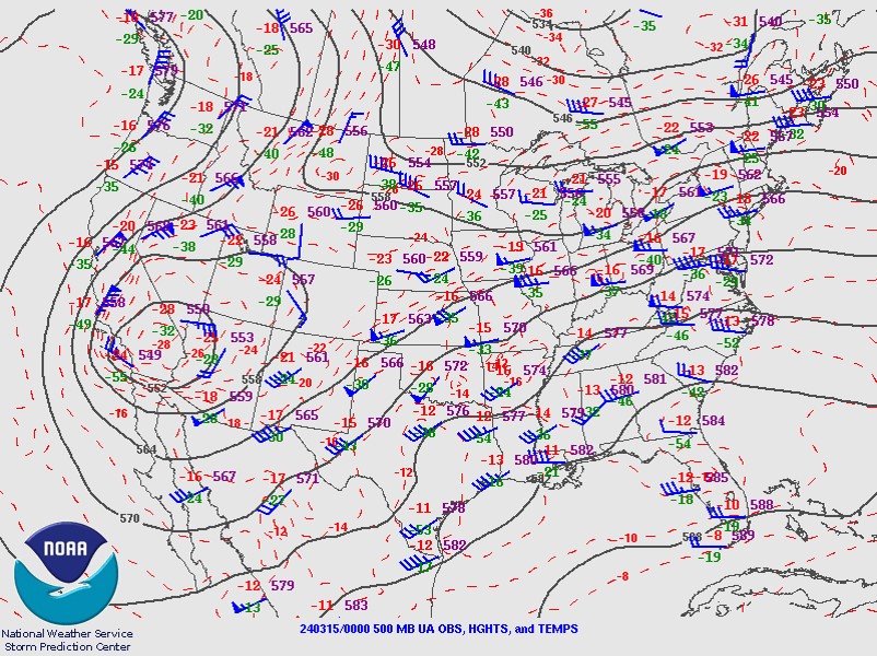
| Figure 1: 850mb analysis for 00Z on March 15, 2024. Note the strong west-southwest flow and tongue of deeper moisture advecting into the area out of the Ohio Valley. | Figure 2: 500mb analysis for 00Z on March 15, 2024. Note the belt of strong, nearly west winds aloft, on top of more south-southwesterly surface winds. This led to strong wind shear. | Figure 3: Surface analysis loop. The severe weather occurred ahead of an approaching cold front and surface low. South-southwest surface winds contributed to strong wind shear. |
Mesoscale Analysis Data
 |
 |
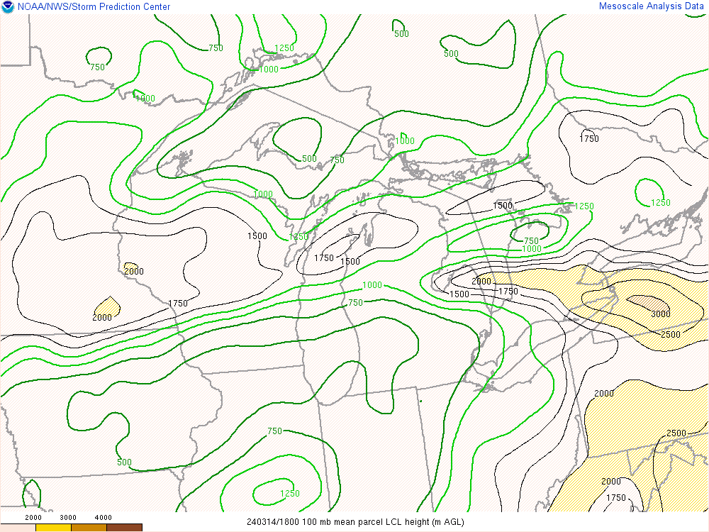 |
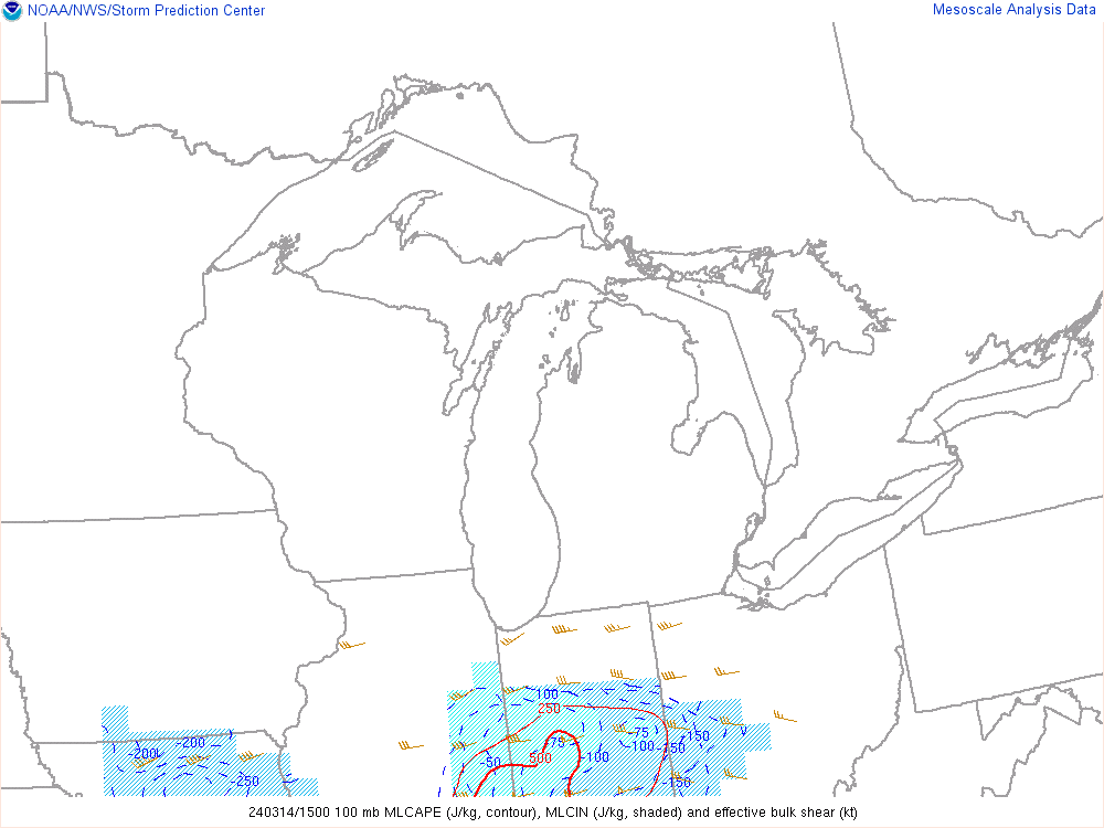
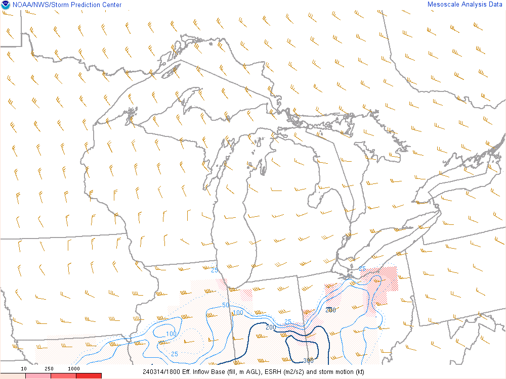
| Figure 4: Loop of Mixed-Layer CAPE and Effective Bulk Shear. MLCAPE values quickly increased to 1000-1500 J/KG across Northwest OH during the early evening hours with effective shear values of about 70 knots. Both parameters supported severe supercell thunderstorms. | Figure 5: Loop of effective Storm Relative Helicity, a measure of low-level wind shear. Values of 300-400+ were in place across Northwest OH as the tornadoes occurred. These values are very supportive of supercells and tornadoes. | Figure 6: Loop of Lifting Condensation Level Heights. Note values near or under 750m across Northwest OH as the tornadoes occurred. Values under 1000m are considered favorable for tornadoes, with values over 1500m unfavorable. |
Mesoscale Analysis & Observed Sounding Data
 |
 |
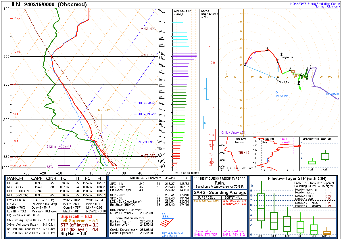 |
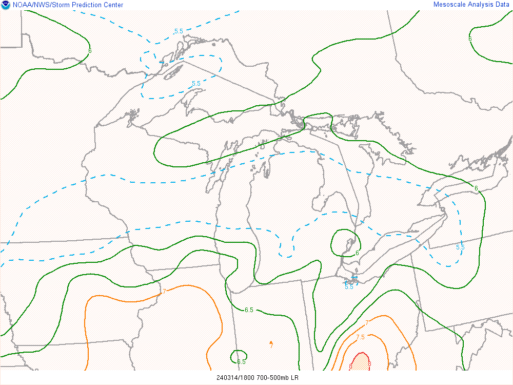
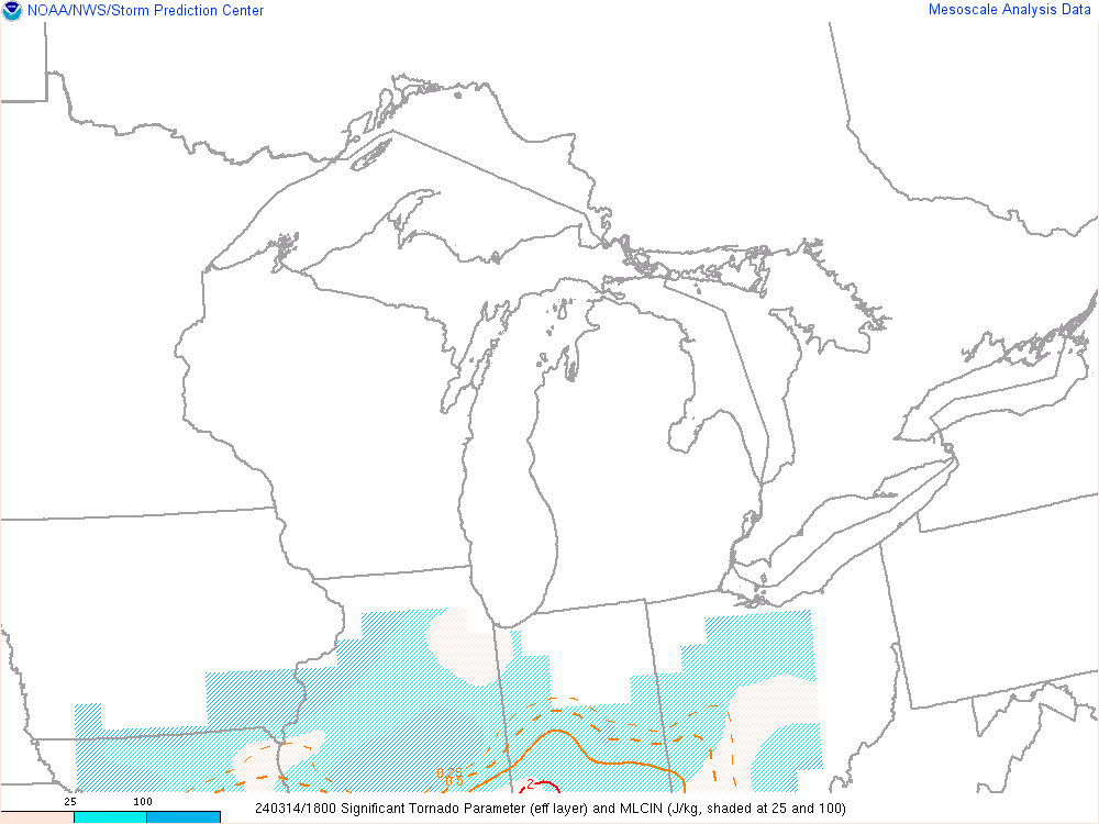
| Figure 7: Loop of mid-level (500-700mb) lapse rates, showing lapse rates of 6.5-7.5C/km in place during the severe weather. These elevated values depict the presence of an "elevated mixed layer" or EML, a common ingredient during some of our higher end severe outbreaks. An EML also increases potential for very large hail. | Figure 8: Loop of effective Significant Tornado Parameter values. Values of 2-3 were briefly observed across Northwest OH as the severe weather and tornadoes occurred. Values higher than 1 are associated with increased potential for tornadoes, potentially strong, with supercells. | Figure 9: Observed environmental sounding from Wilmington, OH from 8 PM on March 14th. Note a moderate amount of instability and a strong amount of wind shear. This forecast sounding is highly favorable for strong tornadoes, and likely represents the environment that encroached on Northwest and North Central OH during the severe weather and tornadoes on March 14th. |
 |
Media use of NWS Web News Stories is encouraged! Please acknowledge the NWS as the source of any news information accessed from this site. |
|