Overview
|
A line of severe thunderstorms moved rapidly southeast out of Michigan and Indiana late in the evening hours of Monday June 13 and during the pre-dawn hours of Tuesday June 14, tracking along a warm front which separated very hot and humid conditions to the southwest from cooler and drier conditions to the northeast. These severe thunderstorms produced a swath of continuous wind damage from winds estimated at 60 to 70 mph from northwest Ohio through interior sections of north central and northeast Ohio. A swath from Richland, Ashland, and Morrow Counties through Wayne, Holmes, and Knox Counties was particularly hard hit with widespread tree damage from winds likely around 80 mph. A large macroburst that tracked across Wayne and Holmes Counties produced estimated 80 to over 90 mph winds from Wooster Township through Millersburg. Thousands of trees were downed along this path, many of which fell on homes, vehicles, and power lines causing widespread power outages. Clean-up and power restoration in Richland, Ashland, Morrow, Wayne, Holmes, and Knox Counties took several days. In addition to the straight line winds, three E-F1 tornadoes touched down. The first tornado touched down 5 miles northeast of Mt. Gilead and ended 6 miles northwest of Chesterville and had maximum winds of 97 mph. The second tornado touched down in Chesterville and ended 5 miles southwest of Fredericktown and had maximum winds of 105 mph. The third tornado touched down 3 miles north of Butler and ended 4 miles south of Perrysville. These tornadoes damaged or destroyed several barns and outbuildings.
This line of thunderstorms was classified as a derecho. A derecho is defined as “A widespread, convectively induced straight-line windstorm, more specifically, any family of downburst clusters produced by an extratropical mesoscale convective system.” (American Meteorological Society, 2014). Furthermore, derechos generally have swaths of damage that extend around 250 to 400 miles in length, around 60 miles in width, and these systems contain 58 mph winds along most of that damage path with a few 75 mph or greater gusts. |
 Radar loop showing the derecho (first round of storms), followed by a secondary thunderstorm complex in the late evening and overnight hours of June 13 into June 14, 2022. |
Tornadoes and Wind:
|
Macroburst
|
||||||||||||||
|
Tornado
|
||||||||||||||||
|
Tornado
|
||||||||||||||||
|
Tornado
|
||||||||||||||||
The Enhanced Fujita (EF) Scale classifies tornadoes into the following categories:
| EF0 Weak 65-85 mph |
EF1 Moderate 86-110 mph |
EF2 Significant 111-135 mph |
EF3 Severe 136-165 mph |
EF4 Extreme 166-200 mph |
EF5 Catastrophic 200+ mph |
 |
|||||
Photos & Video
 |
 |
 |
 |
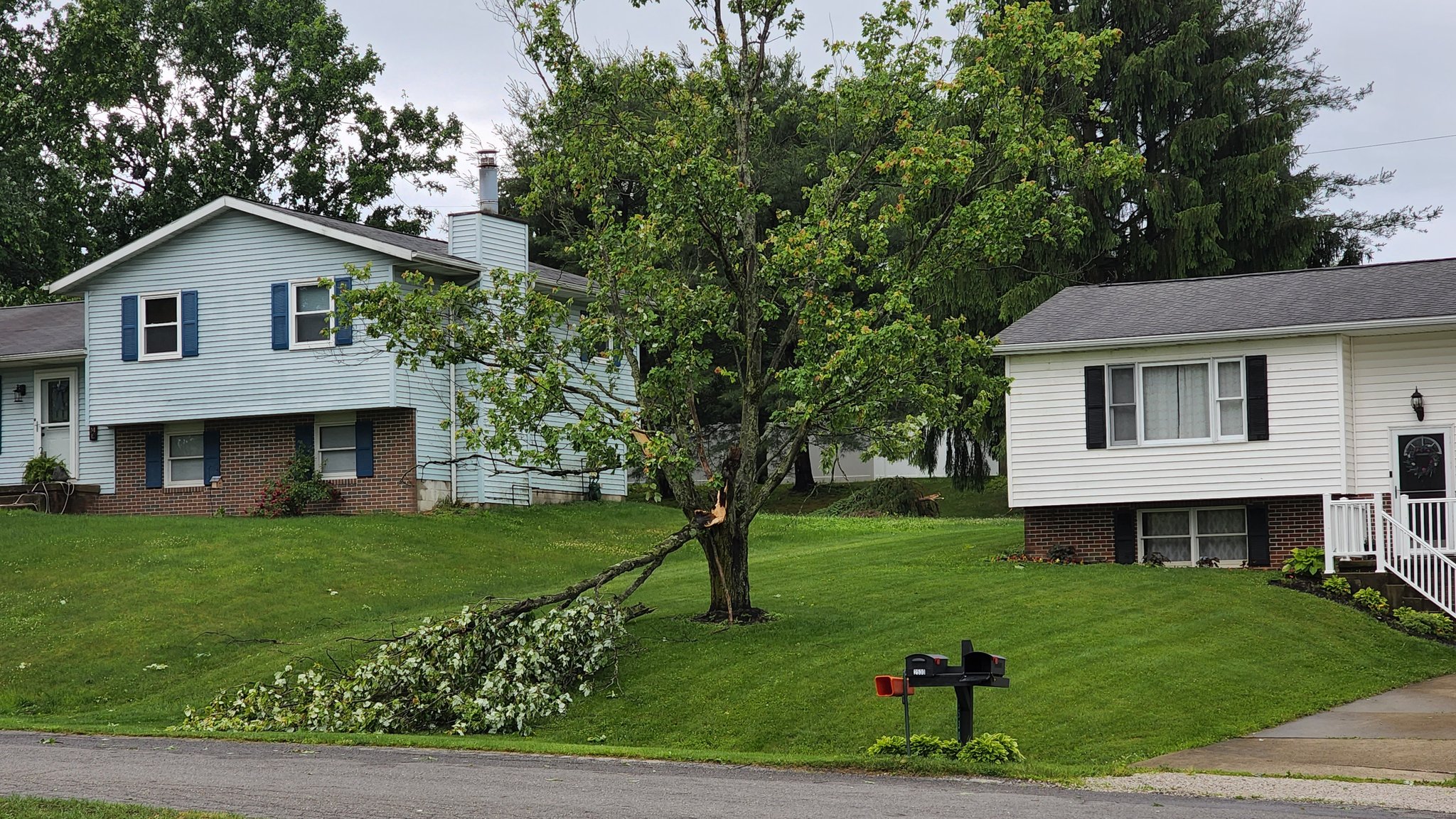
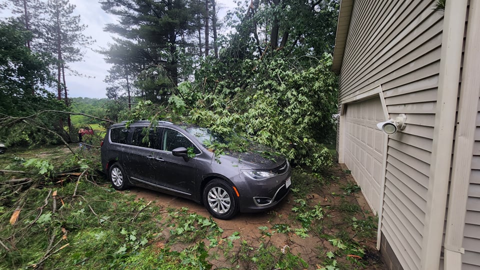
| Damage in Berlin Township (Neil Fischer) |
Trees down off of Batdorf Rd in Wooster (Annie Kobilarcik) |
South of Wooster. Old Columbus Road and off of Batdorf Rd. (Annie Kobilarcik) |
South of Wooster. Old Columbus Road and off of Batdorf Rd. (Annie Kobilarcik) |
 |
 |
 |
 |
| South of Wooster. Old Columbus Road and off of Batdorf Rd. (Annie Kobilarcik) |
South of Wooster. Old Columbus Road and off of Batdorf Rd. (Annie Kobilarcik) |
Skyview Ranch Camp in Millersburg (Eric Ristow) |
Skyview Ranch Camp in Millersburg (Eric Ristow) |
 |
 |
 |
 |
| Skyview Ranch Camp in Millersburg (Eric Ristow) |
Skyview Ranch Camp in Millersburg (Eric Ristow) |
Mt. Gilead. SR 95 just east of SR 61 (Patty) |
Mt. Gilead. SR 95 just east of SR 61 (Patty) |
 |
 |
 |
 |
| Tree down in Martinsburg (Karlin Gingerich) |
Damage in Mansfield just west of US 42 (Jason Crundwell) |
West Salem Damage (Kristi Kay Zgrabik) |
Tree uprooted west of Wooster (Amanda) |
 |
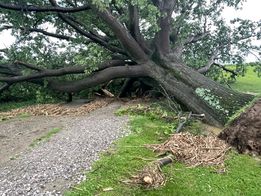 |
| Tree damage in Wooster Memorial Park (Jill Hartmann) |
Southwest of Wooster (Wendy Kingery) |
Radar
|
| Radar loop showing the derecho (first round of storms), followed by a secondary thunderstorm complex in the late evening and overnight hours of June 13 into June 14, 2022. |
Storm Reports

032
NWUS51 KCLE 170726
LSRCLE
PRELIMINARY LOCAL STORM REPORT...SUMMARY
NATIONAL WEATHER SERVICE CLEVELAND OH
326 AM EDT FRI JUN 17 2022
..TIME... ...EVENT... ...CITY LOCATION... ...LAT.LON...
..DATE... ....MAG.... ..COUNTY LOCATION..ST.. ...SOURCE....
..REMARKS..
0935 PM TSTM WND DMG 3 SSW SYLVANIA 41.67N 83.72W
06/13/2022 LUCAS OH TRAINED SPOTTER
10 INCH DIAMETER OAK TREE BRANCH DOWN.
1036 PM TSTM WND GST 2 SW FINDLAY 41.02N 83.67W
06/13/2022 M66 MPH HANCOCK OH ASOS
MEASURED WIND GUST OF 66 MPH (57 KT) AT
KFDY.
1205 AM TSTM WND DMG 5 SSE CONGRESS 40.86N 82.03W
06/14/2022 WAYNE OH PUBLIC
CORRECTS PREVIOUS TSTM WND DMG REPORT FROM 5
SSE CONGRESS. *DELAYED REPORT* HEALTHY 70 FT
PINE TREE DOWNED ON RICE HILL RD IN CHESTER
TOWNSHIP.
1019 PM TSTM WND DMG WOODVILLE 41.45N 83.37W
06/13/2022 SANDUSKY OH PUBLIC
A FEW UTILITY POLES DOWNED IN AND AROUND
WOODVILLE, WITH DAMAGE TO A SUBSTATION AS
WELL. THIS RESULTED IN THE ENTIRE TOWN
LOSING POWER THROUGH THE NIGHT. TIME
ESTIMATED VIA RADAR.
1024 PM TSTM WND GST 1 N GIBSONBURG 41.41N 83.32W
06/13/2022 M58 MPH SANDUSKY OH TRAINED SPOTTER
MEASURED WIND GUST OF 58.3 MPH.
1027 PM TSTM WND DMG 4 SW BAY VIEW 41.43N 82.89W
06/13/2022 SANDUSKY OH PUBLIC
CORRECTS PREVIOUS TSTM WND DMG REPORT FROM 4
SW BAY VIEW. TREE BLOCKING WAHL ROAD IN
WHITES LANDING.
1028 PM TSTM WND GST 1 SSE WALBRIDGE 41.57N 83.48W
06/13/2022 M58 MPH WOOD OH ASOS
ASOS STATION KTDZ TOLEDO.
1030 PM TSTM WND DMG 6 NNE CLYDE 41.38N 82.94W
06/13/2022 SANDUSKY OH PUBLIC
CORRECTS PREVIOUS TSTM WND DMG REPORT FROM 6
NNE CLYDE. TREE DOWN OVER ROAD IN VICKERY.
1033 PM TSTM WND DMG RAWSON 40.96N 83.78W
06/13/2022 HANCOCK OH EMERGENCY MNGR
LARGE TREE ON A ROAD IN RAWSON, WITH 8
UTILITY POLES ALSO DOWNED. SCATTERED TREE
DAMAGE, INCLUDING SOME ON ROADS, REPORTED
ACROSS THE REST OF WESTERN HANCOCK COUNTY,
ESPECIALLY NEAR MCCOMB, BENTON RIDGE AND
JENERA. TIME OF RAWSON DAMAGE ESTIMATED VIA
RADAR.
1035 PM TSTM WND DMG 5 SE RISINGSUN 41.22N 83.36W
06/13/2022 SENECA OH EMERGENCY MNGR
MANY TREE LIMBS AND TREES DOWNED IN AND NEAR
JACKSON TWP, WITH SIGNIFICANT TREE DEBRIS ON
SOME ROADWAYS. A FEW POWER POLES WERE ALSO
DOWNED ALONG COUNTY ROAD 23. TIME ESTIMATED
VIA RADAR.
1038 PM TSTM WND GST ARLINGTON 40.89N 83.65W
06/13/2022 E70 MPH HANCOCK OH TRAINED SPOTTER
TRAINED SPOTTER ESTIMATES 70 MPH WIND GUST.
1038 PM TSTM WND DMG 2 SSW BAY VIEW 41.44N 82.83W
06/13/2022 ERIE OH PUBLIC
TREE ON A HOUSE. TIME ESTIMATED FROM RADAR.
1040 PM TSTM WND GST 2 NNE SANDUSKY 41.49N 82.70W
06/13/2022 M52 MPH LEZ144 OH MESONET
MESONET STATION XSDB 2 NNE SANDUSKY.
1042 PM TSTM WND GST 3 E TIFFIN 41.12N 83.12W
06/13/2022 E60 MPH SENECA OH TRAINED SPOTTER
SPOTTER ESTIMATES 60 MPH WIND GUST, SHINGLES
WERE ALSO SEEN BLOWN OFF OF ROOF.
1050 PM TSTM WND DMG 4 N MILAN 41.35N 82.61W
06/13/2022 ERIE OH PUBLIC
2 FOOT DIAMETER TREE SNAPPED IN HALF.
1050 PM TSTM WND DMG HURON 41.40N 82.56W
06/13/2022 ERIE OH PUBLIC
CORRECTS PREVIOUS TSTM WND DMG REPORT FROM
HURON. LARGE TREE SNAPPED MIDWAY UP.
1052 PM TSTM WND DMG NORWALK 41.24N 82.60W
06/13/2022 HURON OH PUBLIC
DELAYED REPORT- A FEW LIMBS DOWNED,
INCLUDING ONE LARGER THAN 6 INCHES IN
DIAMETER. TIME ESTIMATED VIA RADAR.
1100 PM TSTM WND GST 1 ENE HURON 41.40N 82.55W
06/13/2022 M59 MPH LEZ144 OH MESONET
MESONET STATION HHLO1 HURON.
1108 PM TSTM WND GST 1 SSE MARION 40.57N 83.12W
06/13/2022 M62 MPH MARION OH TRAINED SPOTTER
SPOTTER REPORTS 62.4 MPH WIND GUST.
1110 PM TSTM WND DMG 2 WSW WALDO 40.45N 83.13W
06/13/2022 MARION OH PUBLIC
LARGE SILVER MAPLE DOWN ON SR47.
1110 PM TSTM WND DMG 1 ESE MARION 40.58N 83.10W
06/13/2022 MARION OH TRAINED SPOTTER
LARGE LIMBS DOWN.
1110 PM TSTM WND DMG CALEDONIA 40.63N 82.97W
06/13/2022 MARION OH EMERGENCY MNGR
CORRECTS TIME OF PREVIOUS TSTM WND DMG
REPORT FROM CALEDONIA. TREE FELL ONTO HOME.
1111 PM TORNADO CHESTERVILLE 40.48N 82.68W
06/13/2022 MORROW OH NWS STORM SURVEY
A TORNADO TOUCHED DOWN NEAR CHESTERVILLE AND
TRACKED SOUTHEAST INTO KNOX COUNTY WHERE IT
DISSIPATED NEAR COCHRAN ROAD. THE TOTAL PATH
WAS 7.1 MILES AND NO INJURIES HAVE BEEN
REPORTED. NUMEROUS TREES WERE SNAPPED AND
UPROOTED ALONG THE PATH. A DETACHED GARAGE
WAS COMPLETELY DESTROYED WITH CINDER BLOCKS
THROWN 20 YARDS. A BARN WAS DESTROYED AND
FARM EQUIPMENT DISPLACED 200 TO 300 YARDS.
1112 PM TSTM WND DMG CRESTLINE 40.79N 82.73W
06/13/2022 CRAWFORD OH PUBLIC
DELAYED REPORT- ROOF DAMAGE TO A BUILDING IN
CRESTLINE. TIME ESTIMATED VIA RADAR.
1115 PM TSTM WND DMG 1 ESE MARION 40.58N 83.10W
06/13/2022 MARION OH PUBLIC
MULTIPLE BRANCHES DOWN. TIME ESTIMATED FROM
RADAR.
1115 PM TSTM WND DMG NEW LONDON 41.08N 82.41W
06/13/2022 HURON OH PUBLIC
LARGE TREE DOWN.
1115 PM TSTM WND DMG 2 NNE CASTALIA 41.43N 82.78W
06/13/2022 ERIE OH LAW ENFORCEMENT
ACROSS CASTALIA, BAY VIEW, SANDUSKY, AND
HURON. MULTIPLE TREES AND LIMBS DOWN, SOME
TRANSFORMERS WERE ALSO BLOWN.
1115 PM TSTM WND DMG 3 NE CASTALIA 41.43N 82.78W
06/13/2022 ERIE OH LAW ENFORCEMENT
MULTIPLE TREES AND LIMBS DOWN ACROSS
CASTALIA, BAY VIEW, SANDUSKY, AND HURON.
1117 PM TORNADO 6 NE MOUNT GILEAD 40.60N 82.75W
06/13/2022 MORROW OH NWS STORM SURVEY
A EF-1 TORNADO TOUCHED DOWN NEAR TOWNSHIP
ROAD 46 AND TRACKED SOUTHEAST BEFORE
DISSIPATING NEAR THE INTERSECTION OF
TOWNSHIP ROAD 84 AND TOWNSHIP ROAD 91.
NUMEROUS TREES WERE UPROOTED AND SNAPPED
WITH AREAS OF CONVERGENCE NOTED. NUMEROUS
FARM BUILDINGS SUSTAINED DAMAGE RANGING FROM
COMPLETE LOSS OF ROOF TO COMPROMISED
EXTERIOR ROADS. 2X4 PLANKS IMPALED THE SIDES
AND ROOFS OF BUILDINGS. FARM EQUIPMENT WAS
ALSO DISPLACED APPROXIMATELY 30 YARDS.
1120 PM TSTM WND DMG MOUNT GILEAD 40.55N 82.83W
06/13/2022 MORROW OH PUBLIC
MULTIPLE LARGE TREES DOWN, 4-5 INCHES IN
DIAMETER. DIME SIZE HAIL.
1122 PM TSTM WND DMG LEXINGTON 40.68N 82.59W
06/13/2022 RICHLAND OH TRAINED SPOTTER
TREES SNAPPED IN HALF, POWER LINES DOWN.
1122 PM TSTM WND DMG MANSFIELD 40.76N 82.53W
06/13/2022 RICHLAND OH PUBLIC
EXTENSIVE TREE DAMAGE IN AND AROUND
MANSFIELD.
1122 PM TSTM WND DMG 2 SW MANSFIELD 40.74N 82.55W
06/13/2022 RICHLAND OH PUBLIC
POWER POLE FELL ONTO DELIVERY TRUCK.
1122 PM TSTM WND DMG 4 ESE MOUNT GILEAD 40.53N 82.76W
06/13/2022 MORROW OH PUBLIC
LARGE TREE DOWN. TIME ESTIMATED FROM RADAR.
1125 PM TSTM WND DMG 2 SSW MANSFIELD 40.74N 82.54W
06/13/2022 RICHLAND OH PUBLIC
LARGE TREE FELL ON HOME.
1127 PM TSTM WND DMG BELLVILLE 40.62N 82.51W
06/13/2022 RICHLAND OH PUBLIC
SEVERAL LARGE TREES UPROOTED.
1127 PM TSTM WND DMG PERRYSVILLE 40.66N 82.31W
06/13/2022 ASHLAND OH PUBLIC
EXTENSIVE TREE DAMAGE IN AND AROUND
PERRYSVILLE.
1129 PM TSTM WND DMG FREDERICKTOWN 40.48N 82.55W
06/13/2022 KNOX OH PUBLIC
SEVERAL TREES SNAPPED OR UPROOTED.
1129 PM TSTM WND DMG ASHLAND 40.87N 82.32W
06/13/2022 ASHLAND OH PUBLIC
EXTENSIVE TREE AND POWER POLE DAMAGE IN AND
AROUND ASHLAND.
1130 PM TSTM WND DMG LEXINGTON 40.68N 82.59W
06/13/2022 RICHLAND OH AMATEUR RADIO
TIME ESTIMATED FROM RADAR. ROOF BLOWN OFF OF
ONE MOBILE HOME.
1131 PM TSTM WND GST BAILEY LAKES 40.95N 82.36W
06/13/2022 M62 MPH ASHLAND OH AMATEUR RADIO
AMATEUR RADIO SPOTTER MEASURED 62 MPH WIND
GUST.
1132 PM TSTM WND DMG 4 E ASHLAND 40.88N 82.25W
06/13/2022 ASHLAND OH FIRE DEPT/RESCUE
SHINGLES BLOWN OFF ROOF.
1132 PM TSTM WND DMG 3 NNE MIFFLIN 40.82N 82.34W
06/13/2022 ASHLAND OH PUBLIC
LARGE TREE DOWN.
1133 PM TORNADO 3 N BUTLER 40.63N 82.42W
06/13/2022 RICHLAND OH NWS STORM SURVEY
THE NATIONAL WEATHER SERVICE CONDUCTED A
STORM DAMAGE SURVEY IN CONJUNCTION WITH
EMERGENCY MANAGEMENT OFFICIALS IN RICHLAND
AND ASHLAND COUNTIES. THE DAMAGE ASSESSMENT
DETERMINED AN EF-1 (86-110 MPH) TORNADO
TOUCHED DOWN ABOUT 3 MILES WEST OF NEWVILLE
AT 1133 PM EDT ON JUNE 13. THE TORNADO
TOUCHED DOWN AND DESTROYED AN OUTBUILDING
NEAR POSSUM RUN ROAD AND SNYDER ROAD. THE
TORNADO TRACKED EASTWARD SOUTH OF POSSUM RUN
ROAD AND PRODUCED EXTENSIVE TREE DAMAGE AS
IT MOVED EAST AND REMAINED SOUTH OF PLEASANT
HILL LAKE. THE TORNADO THEN TURNED SOUTHEAST
AND BECAME MORE INTERMITTENT AND ENTERED
MOHICAN STATE PARK AND PRODUCED ADDITIONAL
TREE DAMAGE.
1133 PM TSTM WND DMG 2 N BUTLER 40.62N 82.42W
06/13/2022 RICHLAND OH NWS STORM SURVEY
A SECTION OF ROOF OF A FARM BUILDING WAS
BLOWN OFF.
1135 PM TSTM WND DMG 3 ESE BUTLER 40.57N 82.36W
06/13/2022 RICHLAND OH PUBLIC
SEVERAL LARGE TREES SNAPPED ON HARRIS RD.
1135 PM TSTM WND DMG 3 WSW PERRYSVILLE 40.64N 82.38W
06/13/2022 RICHLAND OH PUBLIC
EXTENSIVE TREE DAMAGE ON OH-95 NEAR 603.
1135 PM TSTM WND DMG 3 NNE BUTLER 40.63N 82.40W
06/13/2022 RICHLAND OH NWS STORM SURVEY
STRUCTURAL DAMAGE TO A HOUSE. THE PORCH WAS
DAMAGED. THE CHIMNEY WAS DESTROYED AND A
LARGE ANTENNA WAS TORN FROM THE HOUSE.
1137 PM TSTM WND DMG JEROMESVILLE 40.80N 82.20W
06/13/2022 ASHLAND OH PUBLIC
EXTENSIVE TREE DAMAGE IN AND AROUND
JEROMESVILLE.
1138 PM TSTM WND DMG PERRYSVILLE 40.66N 82.31W
06/13/2022 ASHLAND OH TRAINED SPOTTER
MULTIPLE TREES DOWN AND/OR UPROOTED.
1140 PM TSTM WND DMG LOUDONVILLE 40.63N 82.23W
06/13/2022 ASHLAND OH PUBLIC
EXTENSIVE TREE DAMAGE IN AND AROUND
LOUDONVILLE INCLUDING A LARGE 70 FOOT TALL
TREE WITH A 36 INCH DIAMETER.
1140 PM TSTM WND DMG 5 SSW LOUDONVILLE 40.56N 82.27W
06/13/2022 ASHLAND OH PUBLIC
NUMEROUS TREES DOWN ALONG SR-3 NEAR THE
ASHLAND-KNOX COUNTY LINE.
1145 PM TSTM WND DMG LOUDONVILLE 40.63N 82.23W
06/13/2022 ASHLAND OH PUBLIC
NUMEROUS TREES DOWN THROUGHOUT LOUDONVILLE.
1145 PM TSTM WND DMG POLK 40.95N 82.21W
06/13/2022 ASHLAND OH PUBLIC
EXTENSIVE TREE DAMAGE IN AND AROUND POLK.
1148 PM TSTM WND DMG 1 E SHREVE 40.68N 82.01W
06/13/2022 WAYNE OH PUBLIC
MULTIPLE TREES DOWN.
1149 PM TSTM WND DMG SHREVE 40.68N 82.02W
06/13/2022 WAYNE OH PUBLIC
SIGNIFICANT DAMAGE TO A BARN IN SHREVE.
1150 PM TSTM WND DMG 4 WSW WOOSTER 40.80N 82.00W
06/13/2022 WAYNE OH PUBLIC
*DELAYED REPORT* LARGE AREA OF TREES DOWN ON
US-30 JUST BEFORE US250.
1150 PM TSTM WND DMG 4 E JEROMESVILLE 40.81N 82.11W
06/13/2022 WAYNE OH PUBLIC
*DELAYED REPORT* TREES DOWNED ONTO HOME ON
OLD LINCOLN WAY.
1150 PM TSTM WND DMG 1 SW GLENMONT 40.51N 82.10W
06/13/2022 HOLMES OH PUBLIC
MULTIPLE BRANCHES LARGER THAN 6 INCHES IN
DIAMETER DOWN. TIME ESTIMATED VIA RADAR.
1159 PM TSTM WND DMG MARTINSBURG 40.27N 82.35W
06/13/2022 KNOX OH PUBLIC
LARGE TREE DOWN.
1200 AM TSTM WND DMG 4 N SHREVE 40.73N 82.04W
06/14/2022 WAYNE OH PUBLIC
*DELAYED REPORT* ROOF DAMAGE TO THREE HOMES
AND NUMEROUS TREES UPROOTED OR SNAPPED ON
ELYRIA RD, SPRINGVILLE RD AND MILLBROOK RD.
1201 AM TSTM WND DMG 3 NNW KILLBUCK 40.53N 82.01W
06/14/2022 HOLMES OH BROADCAST MEDIA
DELAYED REPORT- SEVERAL LARGE TREES DOWN ON
A PROPERTY, WITH ONE DAMAGING A DECK AND
ANOTHER LANDING ON A CAR.
1202 AM TSTM WND DMG 4 ESE CONGRESS 40.90N 81.99W
06/14/2022 WAYNE OH PUBLIC
BARN DAMAGED WITH A LARGE BRANCH SNAPPED ON
THE SAME PROPERTY. TIME ESTIMATED VIA RADAR.
1205 AM TSTM WND DMG 7 W WOOSTER 40.81N 82.06W
06/14/2022 WAYNE OH PUBLIC
*DELAYED REPORT* SEVERAL LARGE TREES
UPROOTED OR SNAPPED.
1205 AM TSTM WND DMG 1 SW MILLERSBURG 40.54N 81.93W
06/14/2022 HOLMES OH PUBLIC
MORE THAN 20 TREES DOWN ON PERSONAL
PROPERTY.
1208 AM TSTM WND DMG 5 W WOOSTER 40.81N 82.03W
06/14/2022 WAYNE OH PUBLIC
*DELAYED REPORT* SEVERAL HEALTHY, LARGE
TREES SNAPPED OR UPROOTED AT WOOSTER
MEMORIAL PARK ON SILVER RD.
1208 AM TSTM WND DMG 3 NNE POLK 40.99N 82.19W
06/14/2022 ASHLAND OH TRAINED SPOTTER
TREE FELL ONTO HOME.
1209 AM TSTM WND DMG 3 S WOOSTER 40.78N 81.93W
06/14/2022 WAYNE OH BROADCAST MEDIA
MAJOR AND WIDESPREAD TREE DAMAGE IN WOOSTER
TOWNSHIP. ODOT IS CLEARING BLOCKED ROADS
WITH PLOWS. TIME ESTIMATED FROM RADAR.
1209 AM TSTM WND DMG 3 SSW WOOSTER 40.79N 81.96W
06/14/2022 WAYNE OH PUBLIC
SEVERAL LARGE TREES AND UTILITY POLES DOWN
ON OLD COLUMBUS ROAD AND OFF OF BATDORF RD.
1209 AM TSTM WND DMG 2 NE MILLERSBURG 40.57N 81.88W
06/14/2022 HOLMES OH PUBLIC
SUBSTANTIAL DAMAGE AT SKYVIEW RANCH
CHRISTIAN CAMP. MANY FALLEN TREES. SOME
TREES CRUSHED CARS, DAMAGED BUILDINGS, AND
BLOCKED THE ONLY TWO WAYS OUT OF CAMP.
1210 AM TSTM WND GST 5 ENE SHREVE 40.71N 81.95W
06/14/2022 E94 MPH WAYNE OH NWS STORM SURVEY
AN NWS STORM SURVEY REVEALED A LARGE SWATH
OF SIGNIFICANT STRAIGHT-LINE WIND DAMAGE
ACROSS PORTIONS OF SOUTHERN WAYNE,
SOUTHEASTWARDS INTO CENTRAL AND EASTERN
HOLMES COUNTIES JUST AFTER MIDNIGHT ON JUNE
14, 2022. THIS DAMAGE OCCURRED AS A RESULT
OF AN EMBEDDED MACROBURST WITHIN A
LARGER-SCALE DERECHO WHICH IMPACTED PORTIONS
OF NORTHERN INDIANA AND OHIO DURING THE
OVERNIGHT HOURS ON JUNE 13 AND JUNE 14,
2022. SURVEYORS NOTED THOUSANDS OF TREES
WERE BROUGHT DOWN AND/OR SNAPPED, BEGINNING
JUST SOUTH AND WEST OF THE CITY OF WOOSTER,
OH. IN ADDITION SEVERAL POWER POLES WERE
SNAPPED AND AT LEAST ONE BUILDING WAS
DESTROYED. THE EXTENSIVE AND SIGNIFICANT
DAMAGE SWATH CONTINUED SOUTHEAST INTO HOLMES
COUNTY, ENDING IN THE VICINITY OF THE
MILLERSBURG TO WALNUT CREEK AREA. ESTIMATED
WIND GUSTS WERE GENERALLY IN THE 80 TO 90
MPH RANGE, WITH MAXIMUM WIND GUSTS OF 94 MPH
OVER THE DURATION OF THE MACROBURST.
1211 AM TSTM WND DMG 6 E MILLERSBURG 40.56N 81.80W
06/14/2022 HOLMES OH BROADCAST MEDIA
MULTIPLE TREES UPROOTED IN BERLIN. METAL
ROOF OR SIDING BLOWN OFF OF STRUCTURE. TIME
ESTIMATED VIA RADAR.
1216 AM TSTM WND GST 4 SE HOLMESVILLE 40.59N 81.87W
06/14/2022 E94 MPH HOLMES OH NWS STORM SURVEY
AN NWS STORM SURVEY REVEALED A LARGE SWATH
OF SIGNIFICANT STRAIGHT-LINE WIND DAMAGE
ACROSS PORTIONS OF SOUTHERN WAYNE,
SOUTHEASTWARDS INTO CENTRAL AND EASTERN
HOLMES COUNTIES JUST AFTER MIDNIGHT ON JUNE
14, 2022. THIS DAMAGE OCCURRED AS A RESULT
OF AN EMBEDDED MACROBURST WITHIN A
LARGER-SCALE DERECHO WHICH IMPACTED PORTIONS
OF NORTHERN INDIANA AND OHIO DURING THE
OVERNIGHT HOURS ON JUNE 13 AND JUNE 14,
2022. SURVEYORS NOTED THOUSANDS OF TREES
WERE BROUGHT DOWN AND/OR SNAPPED, BEGINNING
JUST SOUTH AND WEST OF THE CITY OF WOOSTER,
OH. IN ADDITION SEVERAL POWER POLES WERE
SNAPPED AND AT LEAST ONE BUILDING WAS
DESTROYED. THE EXTENSIVE AND SIGNIFICANT
DAMAGE SWATH CONTINUED SOUTHEAST INTO HOLMES
COUNTY, ENDING IN THE VICINITY OF THE
MILLERSBURG TO WALNUT CREEK AREA. ESTIMATED
WIND GUSTS WERE GENERALLY IN THE 80 TO 90
MPH RANGE, WITH MAXIMUM WIND GUSTS OF 94 MPH
OVER THE DURATION OF THE MACROBURST.
1221 AM TSTM WND DMG HOLMESVILLE 40.63N 81.92W
06/14/2022 HOLMES OH PUBLIC
EXTENSIVE DAMAGE TO TREES AND POWER POLES,
WITH SEVERAL TREES DOWN ON HOMES IN THE
VILLAGE OF HOLMESVILLE.
1242 AM TSTM WND DMG 1 SSW WOOSTER 40.80N 81.94W
06/14/2022 WAYNE OH TRAINED SPOTTER
LARGE TREE, 18 INCH DIAMETER, DOWN.
0158 AM HAIL 3 NNE BOWLING GREEN 41.42N 83.62W
06/14/2022 E0.75 INCH WOOD OH TRAINED SPOTTER
DIME SIZE HAIL.
0226 AM TSTM WND DMG 3 NW BRADNER 41.35N 83.47W
06/14/2022 WOOD OH NWS EMPLOYEE
LARGE TREE DOWNED, DOING SOME DAMAGE TO A
BACK DECK. TIME ESTIMATED VIA RADAR.
0235 AM TSTM WND GST 4 E PORT CLINTON 41.52N 82.87W
06/14/2022 M41 MPH OTTAWA OH AWOS
AWOS STATION KPCW PORT CLINTON.
0300 AM FLOOD FREMONT 41.35N 83.11W
06/14/2022 SANDUSKY OH EMERGENCY MNGR
SEWERS WERE OVERWHELMED BY TORRENTIAL
RAINFALL AND FLOODED THE COUNTY COURTHOUSE
BASEMENT WITH 3 INCHES OF WATER. SCATTERED
BASEMENT FLOODING REPORTED ACROSS THE
COUNTY. TIME OF COURTHOUSE FLOODING
ESTIMATED VIA RADAR.
0311 AM TSTM WND DMG SHELBY 40.88N 82.66W
06/14/2022 RICHLAND OH PUBLIC
25 FOOT 24 INCH DIAMETER PINE TREE SNAPPED.
0312 AM TSTM WND DMG 3 WSW SAVANNAH 40.95N 82.41W
06/14/2022 ASHLAND OH NWS STORM SURVEY
A SECTION OF ROOF OF A FARM BUILDING WAS
BLOWN OFF AND THE DEBRIS WAS BLOWN TOWARD
THE SOUTHEAST. THREE CALF HUTCHES WERE
AIRBORNE AND CARRIED ABOUT 1500 FEET TO THE
SOUTHEAST.
0320 AM TSTM WND DMG 5 NW MIFFLIN 40.81N 82.44W
06/14/2022 RICHLAND OH PUBLIC
*DELAYED REPORT* SEVERAL TREES DOWN AT
WINDSOR RD AND OSBUN RD.
0327 AM TSTM WND DMG WEST SALEM 40.97N 82.11W
06/14/2022 WAYNE OH PUBLIC
LARGE TREE DOWN.
0329 AM TSTM WND DMG 6 SW BAILEY LAKES 40.89N 82.43W
06/14/2022 RICHLAND OH TRAINED SPOTTER
TREE WITH APPROXIMATE DIAMETER OF 12 INCHES
DOWN ON WIRES ON OH-545.
0332 AM TSTM WND GST FREDERICKTOWN 40.47N 82.55W
06/14/2022 E80 MPH KNOX OH NWS STORM SURVEY
DELAYED REPORT - LARGE TREE UPROOTED ONTO A
HOME. NUMEROUS OTHER LARGE LIMBS AND TREES
DOWNED IN AREA.
0333 AM TSTM WND GST FREDERICKTOWN 40.48N 82.55W
06/14/2022 E80 MPH KNOX OH NWS STORM SURVEY
DELAYED REPORT - LARGE TREE DOWN ON HOME.
ADDITIONAL TREES AND LARGE LIMBS DOWN IN
AREA.
0338 AM TSTM WND DMG 6 NNW SHREVE 40.77N 82.06W
06/14/2022 WAYNE OH PUBLIC
CORRECTS DATE FOR 6 NNW SHREVE REPORT. TREE
UPROOTED BY SECOND LINE OF STORMS. TIME
ESTIMATED VIA RADAR. ALSO HAD DOWNED TREES
IN THE AREA FROM THE FIRST LINE OF STORMS
EARLIER IN THE EVENING.
0340 AM TSTM WND DMG 5 WSW WOOSTER 40.79N 82.02W
06/14/2022 WAYNE OH PUBLIC
LARGE PINE TREE UPROOTED AT JEFFERSON RD AND
WILE RD.
0344 AM TSTM WND DMG 5 ENE SHREVE 40.71N 81.94W
06/14/2022 WAYNE OH PUBLIC
SEVERAL TREES DAMAGED AT MORELAND RD AND
MILLERSBURG RD.
0347 AM TSTM WND DMG 3 E CENTERBURG 40.30N 82.65W
06/14/2022 KNOX OH PUBLIC
LARGE TREE BRANCH DOWN ON 657 BETWEEN PERRY
AND WEBSTER.
0352 AM TSTM WND GST 4 N MANSFIELD 40.82N 82.52W
06/14/2022 M61 MPH RICHLAND OH ASOS
ASOS STATION KMFD MANSFIELD.
&&
$$
Environment
Synoptic Analysis
During the late evening and overnight hours of June 13 and 14, 2022, a strong mid/upper level ridge of high pressure (heat dome) was expanding across the Midwest, Tennessee Valley, and Ohio Valley with 500 mb heights of 594 DM centered over the Tennessee Valley. This placed the lower Great Lakes in broad WNW flow with a belt of 60-80 knots from the upper Midwest through the lower Great Lakes. At 03Z (11PM) June 14, a 500 mb shortwave trough could also be seen traversing lower Michigan. This shortwave and its associated upper level divergence generated the enhanced lift necessary to form a thunderstorm complex. At the 850 mb level, a southwesterly 35-40 knot low-level jet developing in response to the mid-level shortwave lifted a warm front north and northeast to a position from the Upper Midwest to central Ohio at 03Z June 14 as can be seen in the tightly packed isotherms and dew point pooling on the 850 mb plot. This strong warm/moist advection into the warm frontal boundary set up a strong temperature and moisture gradient for which the thunderstorm complex could track along from NW to SE. In fact, deep layer moisture convergence at 03Z also showed the strong moisture pooling from lower Michigan into NW and north central Ohio.
.PNG) |
.PNG) |
.PNG) |
| Figure 1: 500 mb height/temp/wind | Figure 2: 850 mb height/temp/dew point | Figure 3: Deep layer moisture flux convergence and 100 mb mean mixing ratio |
Another way to view this temperature and moisture gradient in the vicinity of the warm frontal boundary is to look at surface theta e advection. At 03Z June 14, the surface theta e plot showed a sharp theta e gradient from near Chicago into central Ohio which is almost in the same position as the 850 mb temperature and dew point gradient discussed above. Long-lived thunderstorm complexes that can produce long swaths of wind damage, such as derechos, often propagate close to the theta e gradient, and this derecho was no exception. The 03Z June 14 surface temperature and dew point plot showed very high dew points in the mid to upper 70s surging north and northeast behind the warm front, so the thunderstorm complex had plenty of heat and moisture available to maintain a strong intensity as it tracked along the theta e/temp/moisture gradient, as the low-level jet persistently fed heat and moisture into the system.
 |
 |
| Figure 4: Surface Theta E Advection | Figure 5: Surface temp, dew point, and pmsl |
Synoptic Analysis
The parameter space (environment) was very favorable to support and maintain a convective complex, or in this case Derecho, in an otherwise unfavorable time of day across northern OH. Note almost all of the shown parameters indicate a gradient (values of high to low) located across northern OH. Organized storms will tend to track along these gradients while tapping into the extremely favorable parameter space just to the south of the gradient. Note the northeastward expansion of the EML, seen in figure 3, which was priming the mid-level environment throughout much of the day on June 13.
 |
 |
 |
| Figure 1: MLCAPE at 11 PM EDT on June 13, 2022. Note the strong gradient located across northern OH. The Derecho tracked southeastward along this instability gradient. | Figure 2: Effective shear at 11 PM EDT on June 13, 2022. Note the strong wind field in place associated with the Derecho with effective shear values in excess of 50 knots. | Figure 3: Mid-level lapse rates (700 to 500 mb) at 11 PM EDT on June 13, 2022. Note the northeast extension of the elevated mixed layer (EML) into the area, resulting in steep mid-level lapse rates of 7 to 7.5 degrees C/km. |
 |
 |
| Figure 4: DCAPE at 11 PM EDT on June 13, 2022. Once again, note the strong DCAPE gradient located across northern OH. The DCAPE parameter can aid in determining the damaging wind potential. | Figure 5: Derecho composite at 11 PM EDT on June 13, 2022. Note the strong gradient located across northern OH, owing to the very favorable environment for the Derecho to track through and maintain its strength in an otherwise non-favorable time of day. |
Area Soundings
 |
 |
| Figure 1: Detroit sounding at 8 PM EDT on June 13, 2022. Note the strong wind field resulting in 50 knots of effective shear. Also, note the slight easterly winds near the surface in the sounding. This means that Detroit was located just to the north of the boundary and thus why the instability parameters were so low. | Figure 2: Pittsburgh sounding at 8 PM EDT on June 13, 2022. At this point, Pittsburgh was located just to the south of the boundary, hence the more modest instability parameters. However, the effective shear values were much lower, more in the 30 to 35-knot range. |
 |
Media use of NWS Web News Stories is encouraged! Please acknowledge the NWS as the source of any news information accessed from this site. |
|


