Overview
A cold front moved into northwest OH during the early afternoon of June 1st, slowly working southeast through the evening before stalling across central Ohio overnight. Thunderstorms, some severe, developed along and ahead of this cold front and affected most of our forecast area, with scattered severe weather resulting. Damaging winds were the most prevalent severe weather hazard, though isolated large hail and flooding were also noted. A few thunderstorms developed in the early to mid-afternoon, well ahead of the cold front, over parts of northeast OH and northwest PA. These initial storms were generally non-severe, aside from isolated wind damage from a stronger cell near Massillon in Stark County. The main round of thunderstorms developed closer to the advancing cold front across northwest Ohio during the mid-afternoon hours, from near Findlay to Sandusky, with these thunderstorms then sagging east-southeast across much of northern OH and parts of northwestern PA. Storms initially developed as cells but grew upscale into a line of thunderstorms as they moved southeast into the evening hours. One last storm moved into northwestern Ohio from Indiana during the evening hours and tracked through parts of Hancock, Seneca, Crawford, and Richland Counties before weakening. This storm was accompanied by a swath of wind damage, especially in parts of Hancock and Seneca Counties, along with some hail. This last storm developed along the cold front itself and was able to find a narrow ribbon of air that was not stabilized by the earlier round of storms. A few areas had notable wind damage. The first area is in northern Lorain County, including the Lorain, Elyria, and Sheffield areas where tree damage was fairly widespread, with some trees falling on houses. The responsible storm briefly weakened while moving into western Cuyahoga County, before re-intensifying across southern Cuyahoga County and into Summit County. Tree damage was fairly continuous with this storm from northern Summit County across Portage and into southern Trumbull and northern Mahoning Counties. Hudson, Streetsboro, Newton Falls, Braceville, and Warren all had widespread tree damage, some significant, along with numerous power outages. More than half of Hudson and Streetsboro were without power behind the storm, with some trees falling on houses and with some minor structural damage to a few houses (i.e. a bit of siding peeled off). This is the second time the 80 mph “destructive” severe tag has been utilized in our forecast area since its integration into operations last year. Wind damage was also significant with the cell that moved into northwestern OH in the evening, especially across northern Hancock and parts of Seneca Counties, with significant tree and some structural damage, particularly in the Shawtown and McComb areas in northern Hancock County and near Jackson in Seneca County. A microburst occurred in Meadville as there were many trees down, some on cars and buildings, in a small area centered near downtown and just to the north/northeast, along with some hail in the city. |
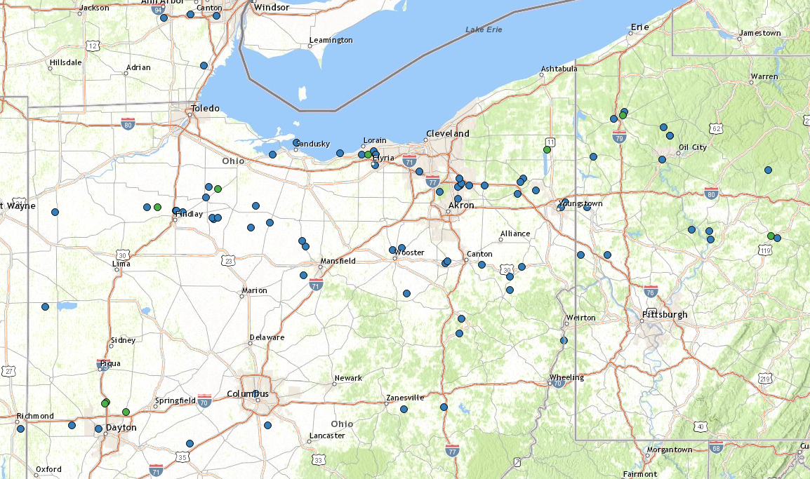
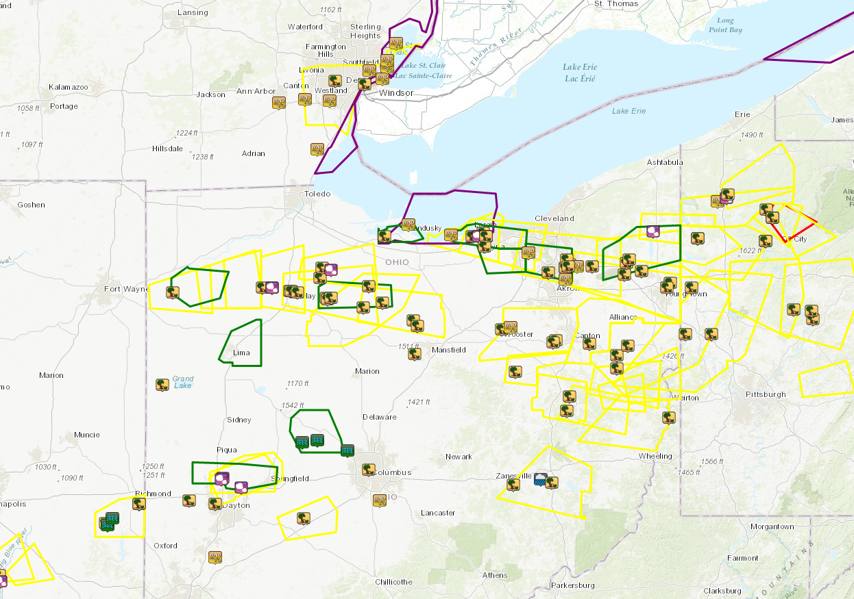 Map of local storm reports (icons) and warnings/advisories issued across the region for the event. Green polygons are Flood Advisories, yellow are Severe Thunderstorm Warnings, red Tornado Warnings, and purple Special Marine Warnings. |
Photos & Video
 |
 |
 |
 |
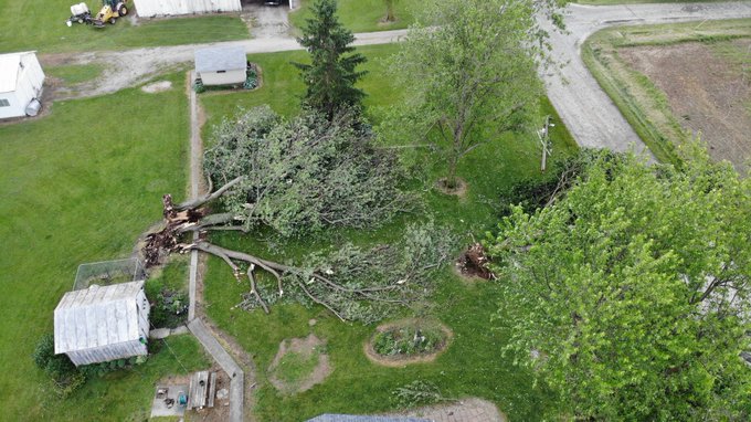
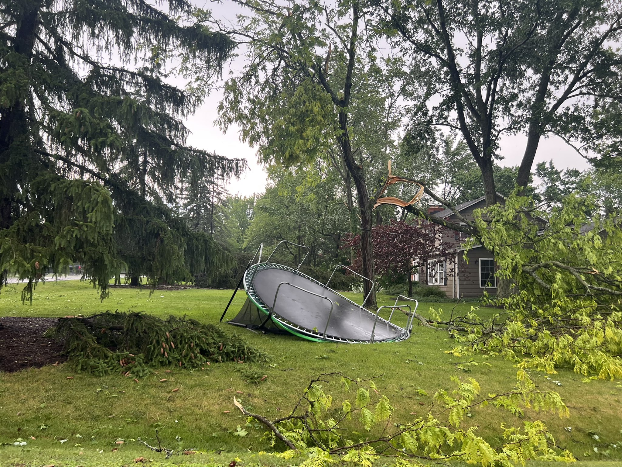
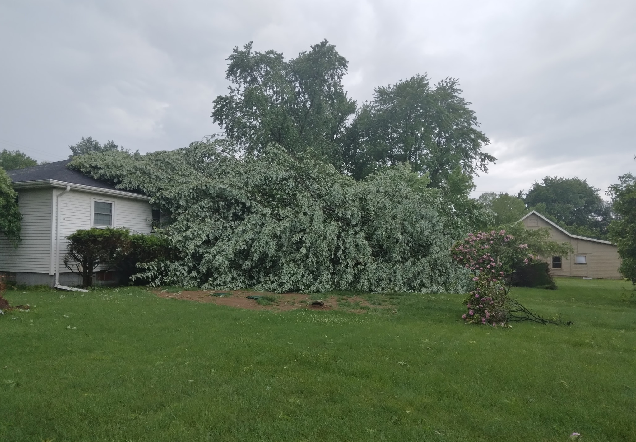
| Tree damage on CR 25 at TR162 in Seneca County. Source: Scanner Media @scannermedia1 | Damaged barn on CR 25 at TR162 in Seneca County. Source: Scanner Media @scannermedia1 | Damage to trees and a trampoline in Hudson, OH (Summit County). Source: Darby Johnson | Several trees snapped in Hudson, OH (Summit County), indicative of winds likely well over 60 MPH. Source: Darby Johnson |
 |
 |
 |
 |
| Tree downed onto a house in Sheffield Village, OH (Lorain County). Source: Denise Scaglione | Quarter to ping-pong-ball-sized hail near Shelby, OH. Source: Alex Monn | Wind damage to a home in Shawtown, OH (Hancock County). Source: Hancock County EMA | Picture of a shelf cloud from Kent, OH, looking north at the storm that did damage across parts of northern Summit, Portage, and Trumbull Counties. Source: Brian Glasscock |
Radar
 |
 |
 |
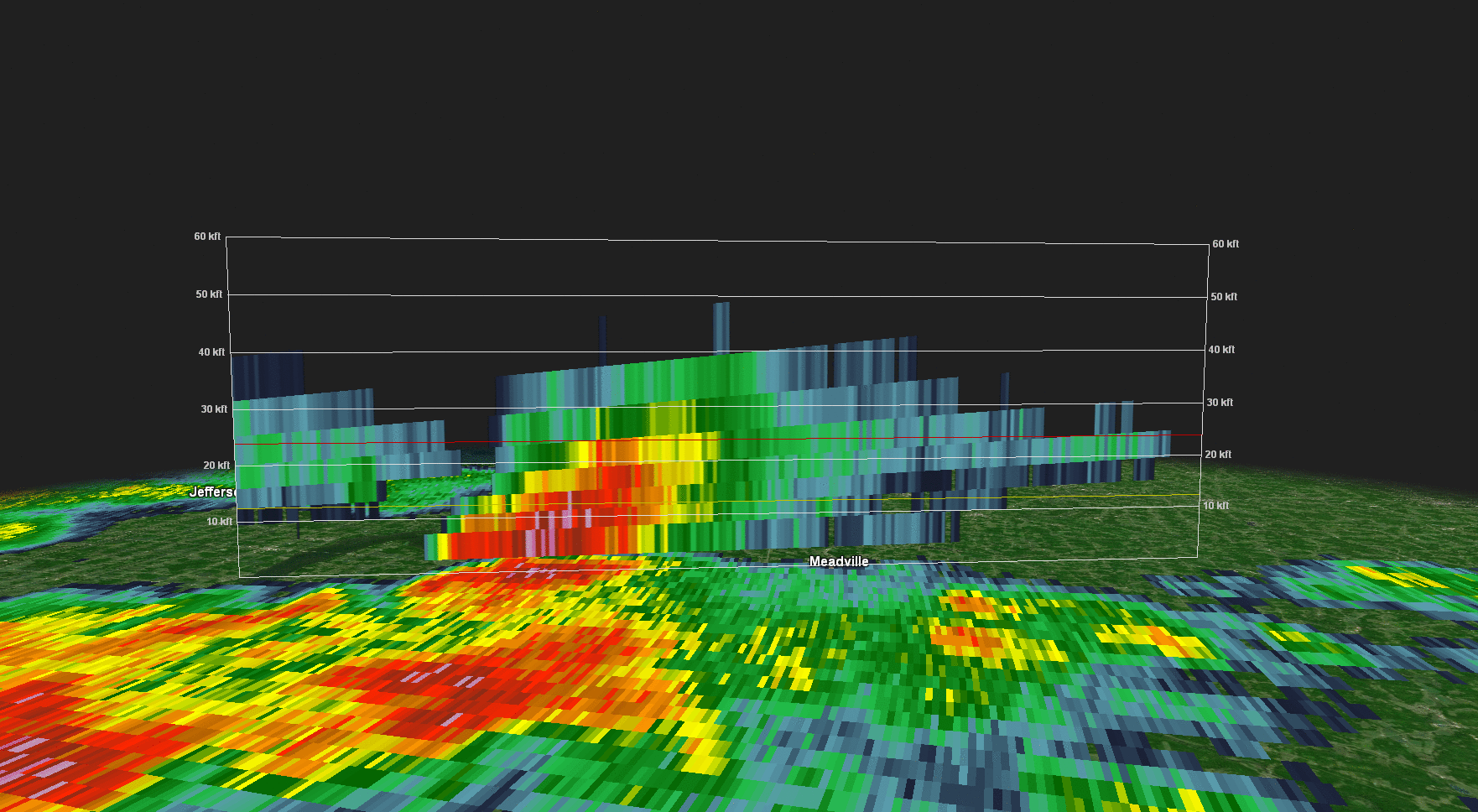 |
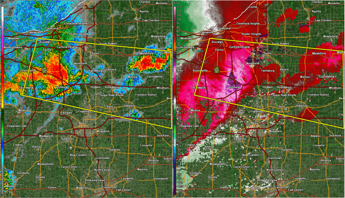
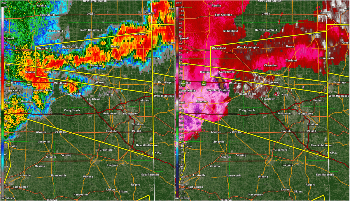
| Radar animation of the event with warning polygons and storm reports. | Radar animation (reflectivity left, velocity right) of the severe thunderstorm that produced extensive wind damage across northern Summit and into Portage County. Note the higher velocities developing as the storm came into Hudson, continuing into Streetsboro. The oranges on the velocity indicate 70-80 MPH winds at the height of the radar beam (a couple thousand feet). | Radar animation (reflectivity left, velocity right) of the severe thunderstorm that produced extensive wind damage across southern Trumbull County. Note how the line took on a bowing shape on reflectivity across southern Trumbull County. Due to distance from the radar and viewing angle, the velocity is not as impressive as it was farther west, but the distinct bowing shape is suggestive of damaging winds occurring. | Animated vertical slice through a severe thunderstorm that affected Crawford County, PA and produced significant wind damage near Meadville around 6:45 PM. Note how early in the loop, the thunderstorm becomes taller and stronger. As all of the rain and hail aloft came crashing to the surface it produced a microburst in Meadville, causing extensive tree damage. This storm also produced quarter-sized hail. |
.gif) |
 |
 |
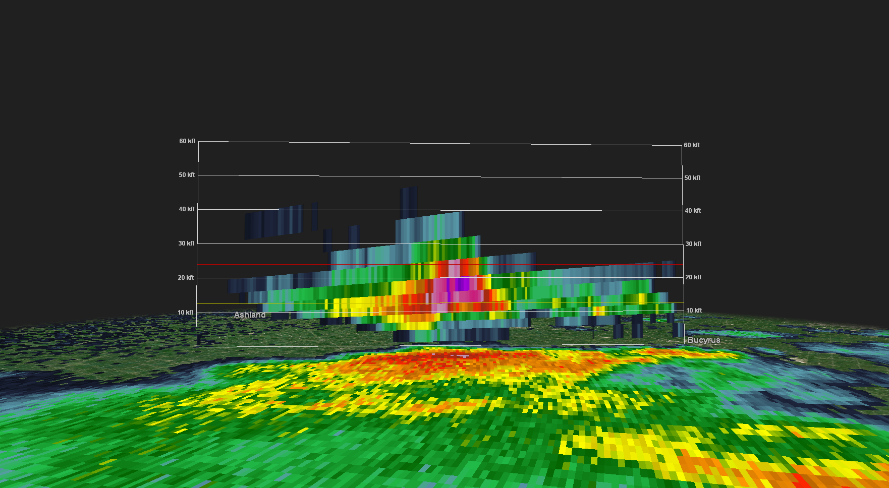 |
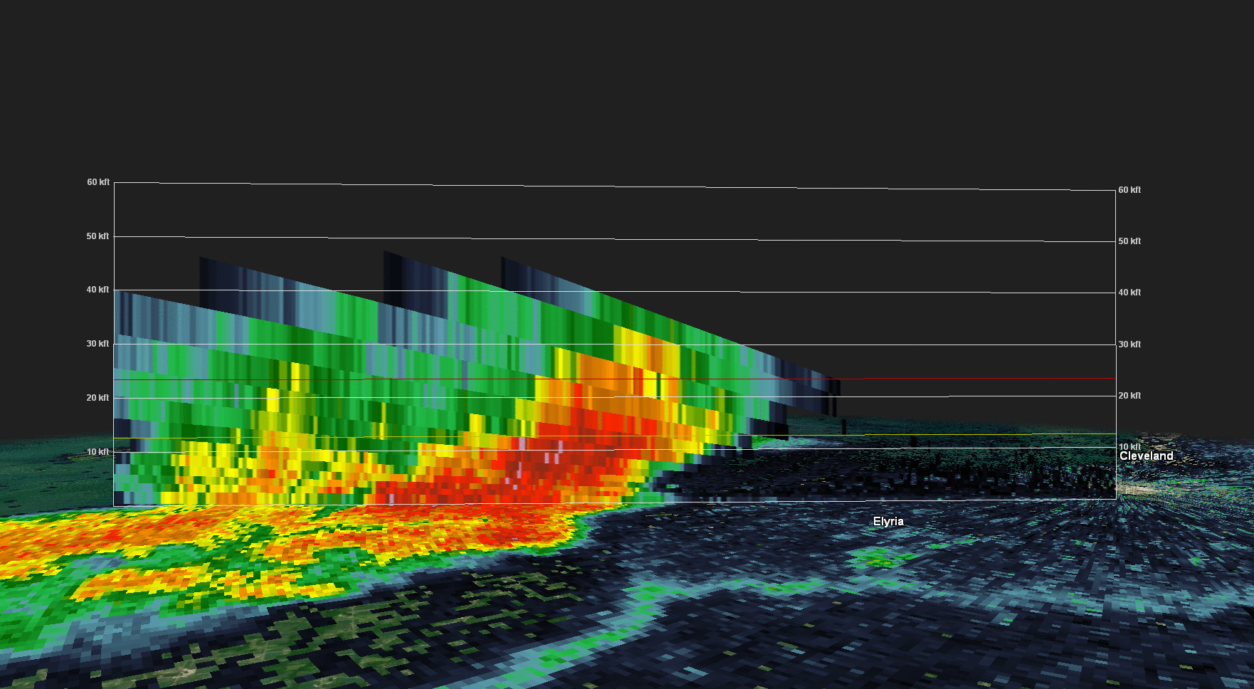
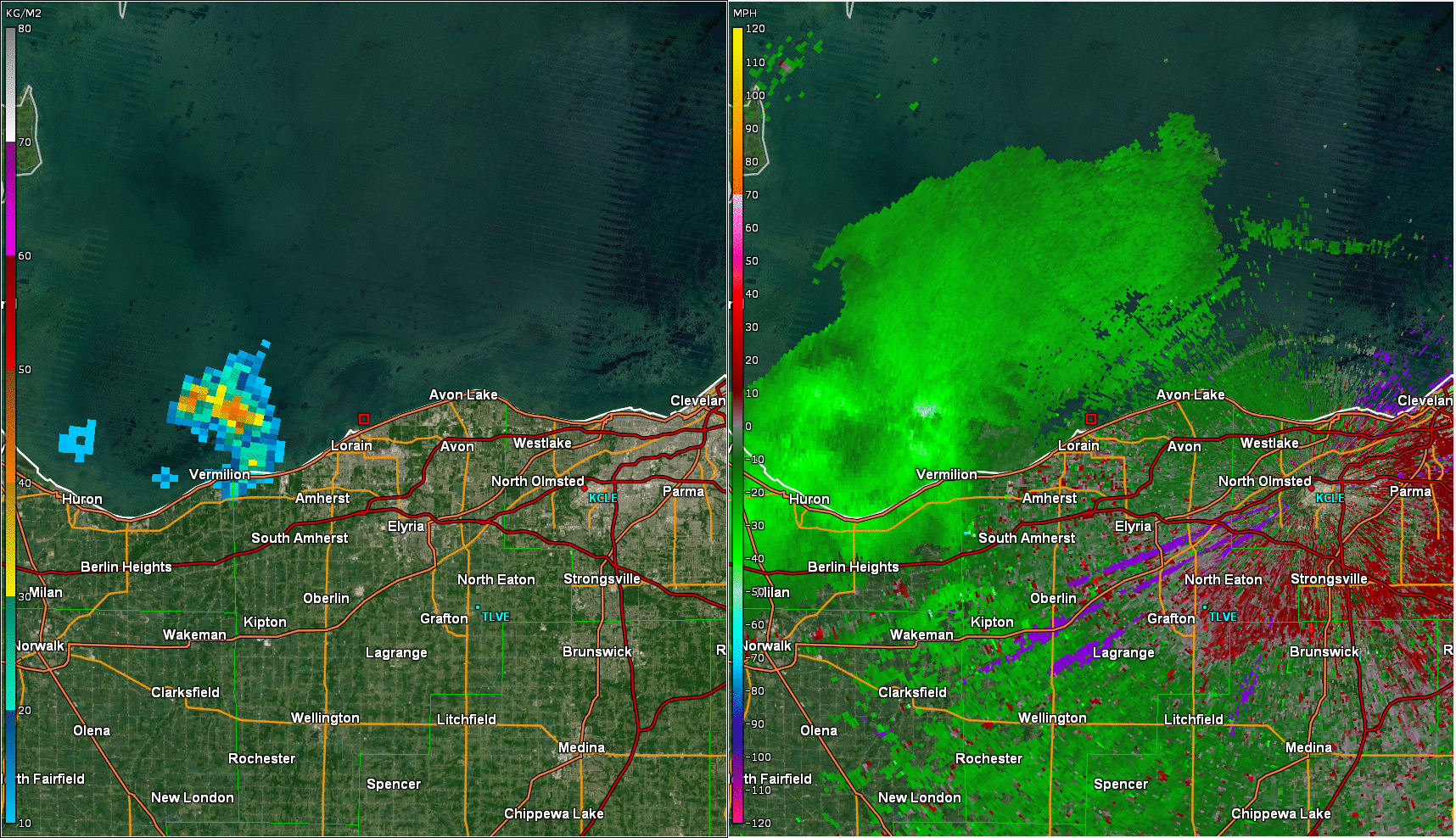
| Animated vertical slice through a severe thunderstorm that affected parts of Hancock and Seneca Counties in the evening. Note the "weak echo region" of lighter returns beneath very heavy returns aloft that appears at times, which is a sign of a very strong thunderstorm updraft. As parts of this core crashed the ground, it produced very strong downburst winds along with quarter-sized hail. | Animated vertical slice through a severe thunderstorm coming into northern Lorain County. Note how early in the loop, pinks and purples expand in the mid-levels of the atmosphere indicating very heavy rain and hail aloft. As this core descending in the Lorain/Elyria area it produced damaging winds. | Reflectivity loop (right) of a developing microburst signature over Lorain County. Note the increasingly strong velocities blowing away from each other. On the left is VIL, which is a measure of liquid suspended by a storm. VIL drops often occur when microbursts occur. | 3D slice of a severe thunderstorm moving out of northern Crawford and into northern Richland County in the evening. Note the large area of 60+ dBZ returns extending to parts of the atmosphere that are colder than -20C, indicative of large hail potential. This storm produced ping pong ball sized hail and damaging winds near Shelby shortly after this image as this thunderstorm core aloft fell to the ground. |
Storm Reports
Map showing wind (blue) and hail (green) reports across the region.
PRELIMINARY LOCAL STORM REPORT...SUMMARY
NATIONAL WEATHER SERVICE CLEVELAND OH
939 AM EDT THU JUN 2 2022

..TIME...   ...EVENT...      ...CITY LOCATION...     ...LAT.LON...
..DATE...   ....MAG....      ..COUNTY LOCATION..ST.. ...SOURCE....
            ..REMARKS..

0250 PM     TSTM WND DMG     MASSILLON               40.79N 81.52W
06/01/2022                   STARK              OH   PUBLIC

            SOCIAL MEDIA PICTURE SHOWING SEVERAL MEDIUM
            TO LARGE TREE LIMBS DOWNED. TIME ESTIMATED
            VIA RADAR.
0251 PM     TSTM WND DMG     1 SW MASSILLON          40.78N 81.54W
06/01/2022                   STARK              OH   TRAINED SPOTTER

            SEVERAL TREES AND LARGE BRANCHES DOWN. ALSO
            PEA TO DIME SIZE HAIL.

0325 PM     TSTM WND DMG     1 N FOSTORIA            41.17N 83.41W
06/01/2022                   SENECA             OH   AMATEUR RADIO

            POWER LINES DOWNED ON THE NORTH SIDE OF
            FOSTORIA. TIME ESTIMATED VIA RADAR.

0327 PM     TSTM WND DMG     4 SE RISINGSUN          41.23N 83.39W
06/01/2022                   SENECA             OH   911 CALL CENTER

            SENECA COUNTY DISPATCH REPORTS TREES DOWN ON
            A BUILDING NEAR TR 172 AND CR 25 NORTH OF
            FOSTORIA. TIME ESTIMATED VIA RADAR.

0341 PM     HAIL             5 WSW BETTSVILLE        41.22N 83.32W
06/01/2022  E1.00 INCH       SENECA             OH   TRAINED SPOTTER

            ALSO ESTIMATED 60 MPH WIND.

0350 PM     TSTM WND DMG     4 WNW CASTALIA          41.42N 82.89W
06/01/2022                   SANDUSKY           OH   911 CALL CENTER

            FOUR POWER POLES DOWN ON US ROUTE 6 AND
            COUNTY RD 294. PERSON TRAPPED IN CAR IN
            BETWEEN POLES. PERSON IS NOT INJURED. TIME
            ESTIMATED VIA RADAR.

0419 PM     TSTM WND DMG     REPUBLIC                41.12N 83.02W
06/01/2022                   SENECA             OH   911 CALL CENTER

            SENECA COUNTY DISPATCH REPORTS A FEW TREES
            DOWN IN REPUBLIC. TIME ESTIMATED VIA RADAR.
0426 PM     MARINE TSTM WIND 3 WNW VERMILION         41.43N 82.36W
06/01/2022  M43 MPH          LEZ145             OH   MESONET

            37 KNOT PEAK WIND. MESONET STATION XVRM
            VERMILION.

0433 PM     TSTM WND DMG     1 SSW LORAIN            41.42N 82.19W
06/01/2022                   LORAIN             OH   911 CALL CENTER

            TREE DOWN ON HOUSE. TIME ESTIMATED FROM
            RADAR.
0440 PM     MARINE TSTM WIND 2 NNE SANDUSKY          41.49N 82.70W
06/01/2022  M43 MPH          LEZ144             OH   MESONET

            37 KNOT PEAK WIND. MESONET STATION XSDB 2
            NNE SANDUSKY.

0442 PM     TSTM WND DMG     1 S SHEFFIELD           41.44N 82.10W
06/01/2022                   LORAIN             OH   PUBLIC

            SOCIAL MEDIA REPORT OF TREE INTO POWER LINES
            AND A CAR ON EAST RIVER RD IN SHEFFIELD
            VILLAGE. TIME ESTIMATED VIA RADAR.

0444 PM     HAIL             3 SE LORAIN             41.42N 82.14W
06/01/2022  M0.88 INCH       LORAIN             OH   TRAINED SPOTTER

            TRAINED SPOTTER REPORTS NICKEL SIZED HAIL
            NEAR ELYRIA AVE AND N RIDGE ROAD IN ELYRIA
            TOWNSHIP.

0449 PM     TSTM WND GST     2 SSE SHEFFIELD         41.42N 82.08W
06/01/2022  E60 MPH          LORAIN             OH   TRAINED SPOTTER

            ALSO ONE HALF INCH HAIL.

0450 PM     TSTM WND DMG     2 SSE ELYRIA            41.36N 82.09W
06/01/2022                   LORAIN             OH   PUBLIC

            REPORT OF TREES AND POWER LINES DOWN
            SOUTHEAST OF ELYRIA.

0453 PM     TSTM WND DMG     3 SSE SHEFFIELD         41.42N 82.08W
06/01/2022                   LORAIN             OH   911 CALL CENTER

            TREE DOWN ON HOUSE.

0457 PM     TSTM WND DMG     4 WNW LEXINGTON         40.71N 82.65W
06/01/2022                   MORROW             OH   EMERGENCY MNGR

            MORROW COUNTY EMERGENCY MANAGER REPORTS A
            ROOF BLOWN OFF A TRAILER AND A TRANSFORMER
            FELL ONTO ANOTHER TRAILER ON STATE ROUTE 97
            NEAR THE RICHLAND COUNTY LINE. TIME
            ESTIMATED VIA RADAR.
0515 PM     HAIL             8 SE ORWELL             41.45N 80.74W
06/01/2022  E1.00 INCH       TRUMBULL           OH   PUBLIC

            DELAYED REPORT. QUARTER-SIZED HAIL IN GREENE
            TWP. REPORT FROM SOCIAL MEDIA WITH PICTURE,
            TIME ESTIMATED VIA RADAR.

0518 PM     TSTM WND GST     1 NNE NORTH ROYALTON    41.32N 81.74W
06/01/2022  E60 MPH          CUYAHOGA           OH   NWS EMPLOYEE

            CORRECTS PREVIOUS TSTM WND GST REPORT FROM 1
            NNE NORTH ROYALTON. CORRECTED FOR TIME AND
            SOURCE.

0529 PM     TSTM WND DMG     3 SSW PENINSULA         41.20N 81.58W
06/01/2022                   SUMMIT             OH   PUBLIC

            TREE DOWN ON RIVERVIEW ROAD, SOUTH OF
            EVERETT. TIME ESTIMATED VIA RADAR.

0535 PM     HAIL             1 SSE HUDSON            41.23N 81.44W
06/01/2022  M1.00 INCH       SUMMIT             OH   PUBLIC

            DELAYED REPORT - 1 INCH HAIL.

0535 PM     TSTM WND DMG     1 SSE HUDSON            41.23N 81.44W
06/01/2022                   SUMMIT             OH   PUBLIC

            DELAYED REPORT - TREES DOWN IN BACKYARD.
            TREE SPLIT AND FELL ON POWER LINE.

0537 PM     TSTM WND DMG     2 E HUDSON              41.25N 81.41W
06/01/2022                   SUMMIT             OH   PUBLIC

            SOCIAL MEDIA REPORT OF NUMEROUS TREES DOWN
            AT HUDSON SPRINGS PARK. TIME ESTIMATED VIA
            RADAR.

0541 PM     TSTM WND GST     1 SSW STOW              41.16N 81.44W
06/01/2022  E60 MPH          SUMMIT             OH   TRAINED SPOTTER

            ESTIMATED 55-60 MPH WIND GUST.

0548 PM     TSTM WND DMG     3 NNW WOOSTER           40.86N 81.95W
06/01/2022                   WAYNE              OH   LAW ENFORCEMENT

            TREE DOWNED ALONG ROUTE 83 JUST NORTH OF
            WOOSTER. TIME ESTIMATED VIA RADAR.

0548 PM     TSTM WND GST     1 WNW SMITHVILLE        40.87N 81.88W
06/01/2022  M53 MPH          WAYNE              OH   ASOS

            ASOS STATION KBJJ WOOSTER.

0548 PM     TSTM WND GST     1 WNW SMITHVILLE        40.87N 81.88W
06/01/2022  M53 MPH          WAYNE              OH   ASOS

            ASOS STATION KBJJ WOOSTER.

0548 PM     TSTM WND GST     STREETSBORO             41.24N 81.35W
06/01/2022  E70 MPH          PORTAGE            OH   TRAINED SPOTTER

            SPOTTER REPORTS 70 MPH WIND GUST AND ONE
            INCH HAIL IN STREETSBORO.

0549 PM     TSTM WND DMG     3 SSE TWINSBURG         41.28N 81.43W
06/01/2022                   SUMMIT             OH   TRAINED SPOTTER

            MULTIPLE TREES SNAPPED OFF.

0552 PM     TSTM WND DMG     1 ESE HUDSON            41.24N 81.42W
06/01/2022                   SUMMIT             OH   911 CALL CENTER

            TREE AND POWER LINES DOWN.

0558 PM     TSTM WND DMG     3 S MANTUA              41.24N 81.23W
06/01/2022                   PORTAGE            OH   PUBLIC

            SOCIAL MEDIA REPORT OF A PAIR OF UPROOTED
            TREES IN SHALERSVILLE TWP. TIME ESTIMATED
            VIA RADAR.

0616 PM     TSTM WND DMG     NEWTON FALLS            41.19N 80.97W
06/01/2022                   TRUMBULL           OH   911 CALL CENTER

            TRUMBULL COUNTY DISPATCH REPORTS WIDESPREAD
            TREE AND POWER LINE DAMAGE ACROSS NEWTON
            FALLS. TIME ESTIMATED VIA RADAR.

0618 PM     TSTM WND DMG     BRACEVILLE TWP          41.26N 80.95W
06/01/2022                   TRUMBULL           OH   911 CALL CENTER

            TRUMBULL COUNTY DISPATCH REPORTS WIDESPREAD
            TREE AND POWER LINE DAMAGE ACROSS
            BRACEVILLE. TIME ESTIMATED VIA RADAR.

0620 PM     TSTM WND DMG     4 WSW CHAMPION HEIGHTS  41.28N 80.93W
06/01/2022                   TRUMBULL           OH   TRAINED SPOTTER

            6 INCH DIAMETER LIMB DOWN.

0627 PM     TSTM WND DMG     2 SSW WARREN            41.21N 80.83W
06/01/2022                   TRUMBULL           OH   LAW ENFORCEMENT

            DELAYED REPORT - NUMEROUS TREES DOWN ACROSS
            WARREN.

0627 PM     TSTM WND DMG     4 ESE HOLMESVILLE       40.60N 81.84W
06/01/2022                   HOLMES             OH   EMERGENCY MNGR

            TREE FELL ONTO POWER LINES IN BENTON AT
            INTERSECTION OF STATE ROUTE 241 AND COUNTY
            ROAD 189. TIME ESTIMATED VIA RADAR.

0639 PM     TSTM WND GST     4 WSW MEADVILLE         41.63N 80.22W
06/01/2022  M59 MPH          CRAWFORD           PA   ASOS

            ASOS STATION KGKJ MEADVILLE.

0643 PM     TSTM WND DMG     2 ESE EAST CANTON       40.77N 81.25W
06/01/2022                   STARK              OH   911 CALL CENTER

            TREE DOWN.

0644 PM     TSTM WND DMG     2 SW HUBBARD            41.14N 80.60W
06/01/2022                   TRUMBULL           OH   911 CALL CENTER

            TREE AND WIRES DOWN. TIME ESTIMATED FROM
            RADAR.

0645 PM     TSTM WND DMG     1 NE YOUNGSTOWN         41.11N 80.63W
06/01/2022                   MAHONING           OH   911 CALL CENTER

            TREE AND WIRES DOWN.

0645 PM     HAIL             MEADVILLE               41.65N 80.15W
06/01/2022  E1.00 INCH       CRAWFORD           PA   BROADCAST MEDIA

            BROADCAST MEDIA REPORTS VIEWERS WITH QUARTER
            SIZED HAIL IN MEADVILLE. TIME ESTIMATED VIA
            RADAR.

0648 PM     TSTM WND DMG     2 NNE MEADVILLE         41.67N 80.14W
06/01/2022                   CRAWFORD           PA   911 CALL CENTER

            TREE DOWN ON HOUSE.

0700 PM     TSTM WND DMG     SHAWTOWN                41.11N 83.87W
06/01/2022                   HANCOCK            OH   EMERGENCY MNGR

            HANCOCK COUNTY EMERGENCY MANAGER REPORTS
            SEVERAL LARGE TREES DOWN AND ROOFS AND
            SIDING BLOWN OFF SEVERAL TRAILERS AND BARNS
            IN SHAWTOWN AND EXTENDING OVER TO MCCOMB.
            TIME ESTIMATED VIA RADAR.

0712 PM     HAIL             MCCOMB                  41.11N 83.79W
06/01/2022  M1.00 INCH       HANCOCK            OH   TRAINED SPOTTER

            TRAINED SPOTTER REPORTED QUARTER SIZED HAIL
            IN MCCOMB.

0712 PM     TSTM WND DMG     MCCOMB                  41.11N 83.79W
06/01/2022                   HANCOCK            OH   TRAINED SPOTTER

            TRAINED SPOTTER REPORTED SEVERAL TREES
            DOWNED IN MCCOMB.

0715 PM     TSTM WND DMG     3 N FINDLAY             41.09N 83.65W
06/01/2022                   HANCOCK            OH   911 CALL CENTER

            SEVERAL UTILITY POLES DOWN. TIME ESTIMATED
            FROM RADAR.

0723 PM     TSTM WND DMG     3 N FINDLAY             41.09N 83.64W
06/01/2022                   HANCOCK            OH   TRAINED SPOTTER

            TREE SNAPPED APPROX 10 FEET UP FROM THE BASE
            IN THE AREA OF TOWNSHIP ROAD 99 AND COUNTY
            ROAD 212 IN FINDLAY. TIME ESTIMATED VIA
            RADAR.

0728 PM     TSTM WND DMG     4 NE FINDLAY            41.08N 83.59W
06/01/2022                   HANCOCK            OH   FIRE DEPT/RESCUE

            TREES DOWN AND BLOCKING ROAD AT COUNTY ROAD
            236 AND COUNTY ROAD 212 NORTHEAST OF
            FINDLAY. TIME ESTIMATED VIA RADAR.

0742 PM     TSTM WND DMG     2 W NEW RIEGEL          41.05N 83.36W
06/01/2022                   SENECA             OH   911 CALL CENTER

            TREES AND POWER LINES DOWN. TIME ESTIMATED
            FROM RADAR.

0745 PM     TSTM WND DMG     2 SW NEW RIEGEL         41.04N 83.35W
06/01/2022                   SENECA             OH   911 CALL CENTER

            TREE DOWN. TIME ESTIMATED FROM RADAR.

0752 PM     TSTM WND DMG     NEW RIEGEL              41.05N 83.32W
06/01/2022                   SENECA             OH   911 CALL CENTER

            SENECA COUNTY DISPATCH REPORTS MANY TREES
            DOWN ACROSS BIG SPRING TOWNSHIP. TIME
            ESTIMATED VIA RADAR.

0800 PM     TSTM WND DMG     5 SSW BLOOMVILLE        40.99N 83.06W
06/01/2022                   CRAWFORD           OH   LAW ENFORCEMENT

            LARGE TREE LIMB DOWNED ON MILLER ROAD JUST
            SOUTH OF THE SENECA/CRAWFORD COUNTY LINE.
            TIME ESTIMATED VIA RADAR.
0807 PM     TSTM WND DMG     3 SSW ATTICA            41.02N 82.91W
06/01/2022                   SENECA             OH   911 CALL CENTER

            SENECA COUNTY DISPATCH REPORTS MANY TREES
            DOWN ACROSS VENICE TOWNSHIP. TIME ESTIMATED
            VIA RADAR.

0836 PM     TSTM WND DMG     2 E SHELBY              40.88N 82.63W
06/01/2022                   RICHLAND           OH   FIRE DEPT/RESCUE

            FIRE DEPARTMENT REPORTS SEVERAL ELECTRICAL
            POLES DOWNED ACROSS STATE ROUTE 96 EAST OF
            SHELBY BETWEEN PLYMOUTH-SPRINGMILL ROAD AND
            INDUSTRIAL TECH PARKWAY. TIME ESTIMATED VIA
            RADAR.
Environment
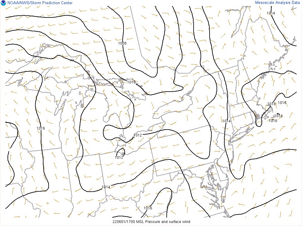
Like most summertime severe threats in this region, we didn't have a large storm system sparking the storms, but instead a cold front and some weaker lift from a modest mid-level vort max moving through. The surface map loop depicts a weak and broad cold front sinking through. Storms developed both along this cold front and along subtle boundaries ahead of the front. Note the belt of moderately strong 500mb flow moving across northern Ohio and into Pennsylvania during the event. This flow was enhanced by a vort max moving through the region, adding a bit of shear and lift to the atmosphere on top of the cold front.
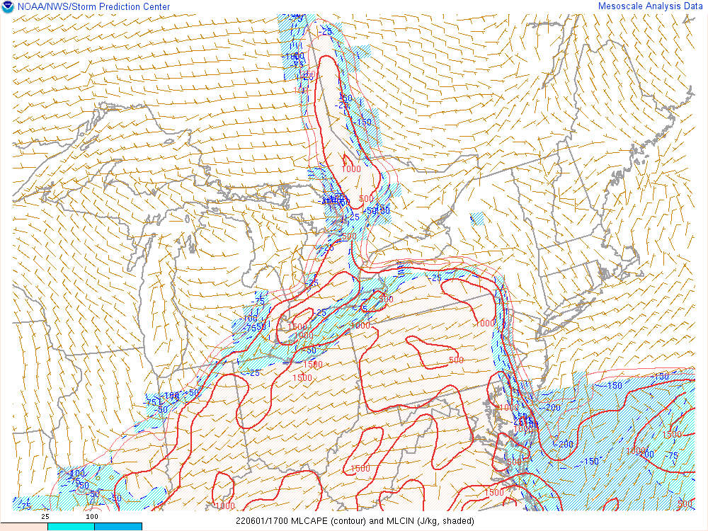
The modest lift and shear described above combined with fairly conducive thermodynamics to produce scattered severe thunderstorms. Air temperatures in the mid 80s and dew points in the mid-upper 60s resulted in moderate instability, per mesoanalysis and observed soundings from Pittsburgh, PA and Wilmington, OH. Mid-level lapse rates (i.e. 500-700mb) were somewhat of a limiting factor, keeping mean-layer (ML) CAPE values mainly in the 1000-2000 J/KG range, which is moderate but not extreme. DCAPE increasing to 800-1000 J/KG ahead of the thunderstorms, along with steep low-level lapse rates of 8-9C/km, helped enhance the damaging wind potential with stronger storms. The modest shear allowed storms to gradually organize into clusters and lines, with a few of the strongest cores also producing isolated large hail. A lack of steeper mid-level lapse rates or stronger shear prevented a more widespread large hail threat. Weak low-level flow also prevented tornadoes from occurring on this day; all of the wind damage came from straight-line winds.
Surface/mid/upper level maps
 |
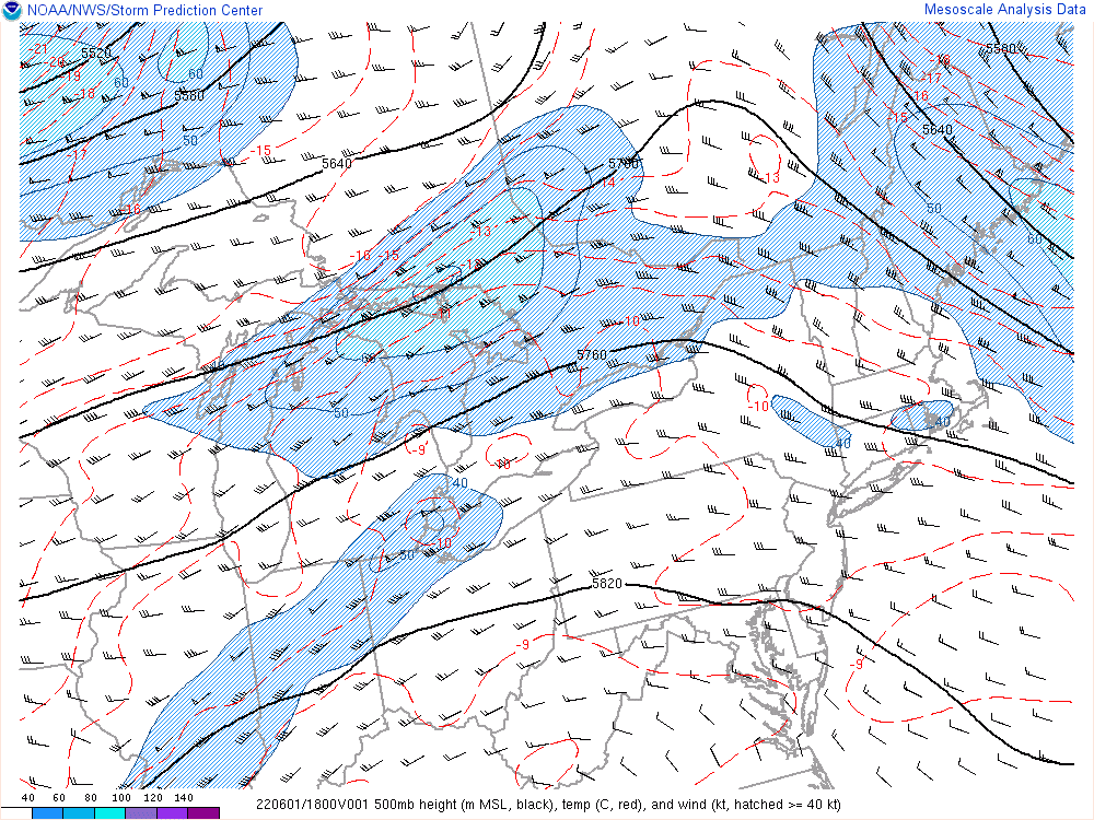 |
| Figure 1: Surface map from 1 PM to 9 PM on June 1, 2022. Note the general lack of any significant surface pressure systems, owing to the limited low-level wind fields. | Figure 2: 500 mb map from 1 PM to 9 PM on June 1, 2022. Note the 40 to 50-knot pocket of west-southwest flow across northern OH. |
Near-storm environment maps
 |
 |
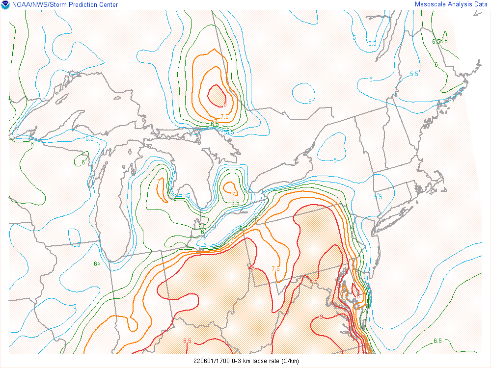 |
| Figure 3: DCAPE map from 1 PM to 9 PM on June 1, 2022. Note the large DCAPE values in excess of 800 J/kg across much of Northeast Ohio, indicative of the damaging wind potential. | Figure 4: MLCAPE map from 1 PM to 9 PM on June 1, 2022. Note MLCAPE values generally in the 1000 to 1500 J/kg range, owing to moderate instability. | Figure 5: Low-level lapse rate (LLLR) map from 1 PM to 9 PM on June 1, 2022. Note LLLR values in excess of 8 degrees C/km, owing to strong low-level heating and aiding to the damaging wind potential. |
Area Soundings
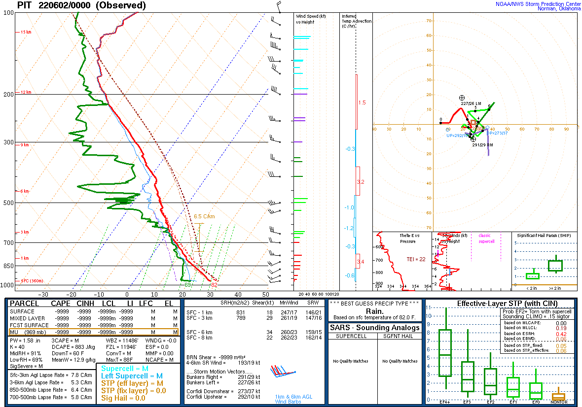
.gif) |
.gif) |
| Figure 6: PBZ sounding from 12Z on the morning of June 1, 2022. Note a relative lack of low-level flow of less than 15 knots. A relative maximum in mid-level flow around 30 to 35 knots at the 500 mb level helped organize the storms. Also note the large DCAPE which was in excess of 800 J/kg, aiding in the damaging wind threat. As heating occurred through the day, instability increased. | Figure 7: ILN sounding from 12Z on the morning of June 1, 2022. Just like the PBZ sounding, there was less than 15 knots of low-level flow. Mid-level flow was slightly less further to the south of our area, closer to 20 to 25 knots. DCAPE was also large in central OH, leading to the damaging wind threat expected for the day. Heating through the afternoon resulted in instability increasing from what this sounding observed at 8 AM. |
 |
.gif) |
| Figure 8: PBZ sounding from 0Z/8pm on the evening of June 1, 2022. While CAPE values are missing, one can see on the sounding that much greater instability persisted through the day. Low-level lapse rates steepened to near 8C/km, with MLCAPE values likely near 1500 J/KG and DCAPE values nearing 900 J/KG. Moderate flow aloft led to around 35 knots of deep-layer shear, leading to longer-lasting and more organized storms. | Figure 7: ILN sounding from 0Z/8pm on the evening of June 1, 2022. Similar to Pittsburgh, there's much more CAPE than in the morning, with over 1500 J/KG of MLCAPE and even higher values of surface-based CAPE (which seems to be locally influenced by higher dew points near ILN). This moderate instability, combined with about 30 knots of deep-layer shear, helped fuel scattered severe thunderstorms. |
 |
Media use of NWS Web News Stories is encouraged! Please acknowledge the NWS as the source of any news information accessed from this site. |
|

