Overview
|
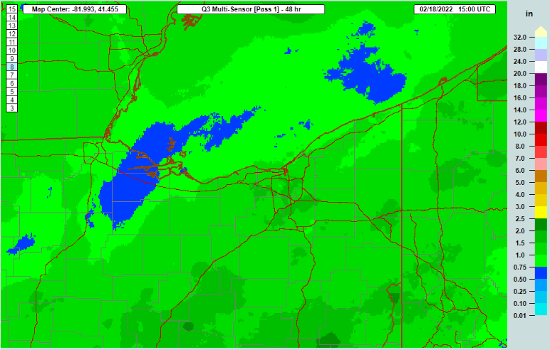
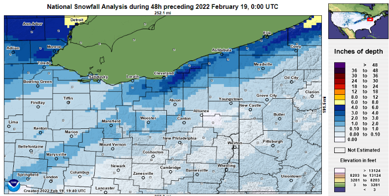
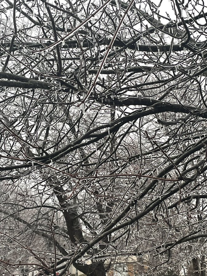
A double threat weather system impacted the region on Feb 16-18, starting with a flooding event due to snowmelt and heavy precipitation, followed by a wintry mix that eventually transitioned to all snow. The region was primed for a flooding event due to a widespread snowpack ranging from 0.5-1.0” water equivalent across much of the area, except 2-3” water equivalent in the snowpack across the snowbelt counties. Warm temperatures in the 50s were effective at melting most of the snowpack before and during the rain event on February 17 with additional precipitation of 0.5-1.0” across NW Ohio, 1-1.50” across the snowbelt, and 1.5-2” across our southeastern counties where the worst flooding occurred. Most area rivers experienced minor to moderate flooding which was aggravated at times by ice jams. During the afternoon and evening on February 17, a strong cold front started to push south, undercutting warm air aloft and causing a period of freezing rain. The freezing rain was heaviest across northern Ohio where 0.10-0.20” of accumulation occurred. As colder air wrapped into the system, a gradual transition to sleet and snow eventually occurred. Snow amounts ranged from 0.5-2” south of Route 30 to as much as 2-4” in the Toledo area and 3-6” across the snowbelt.
|
|
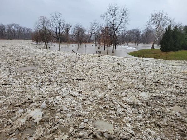
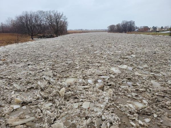
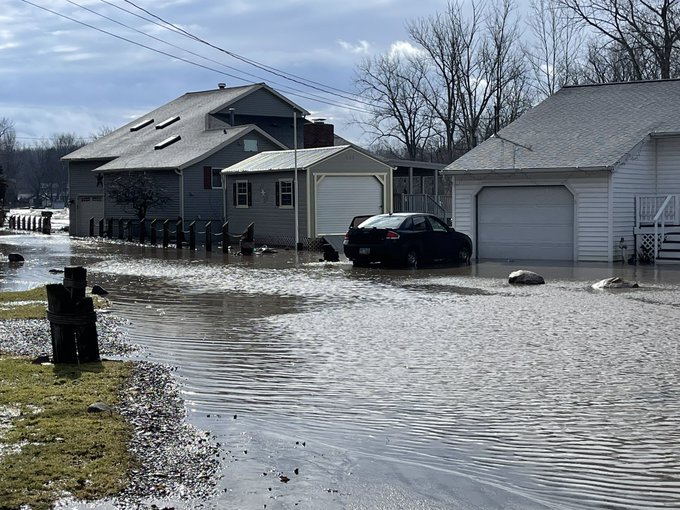
Flooding
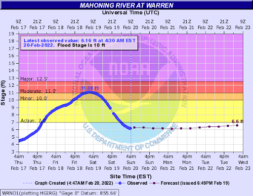
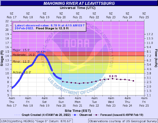
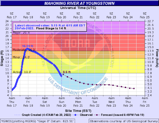
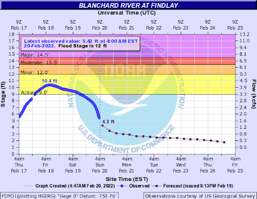
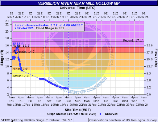
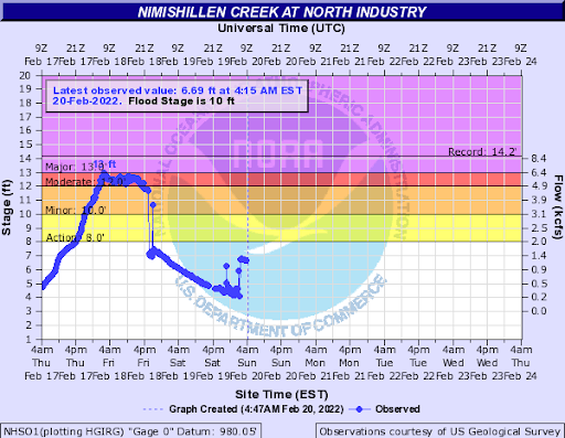
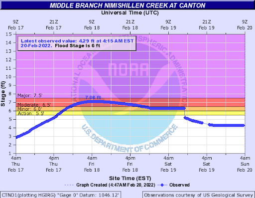
Numerous area rivers experienced some sort of flooding throughout the event, with some river stages reaching moderate to near or just above major flood levels at times.
Hydrographs
 |
 |
 |
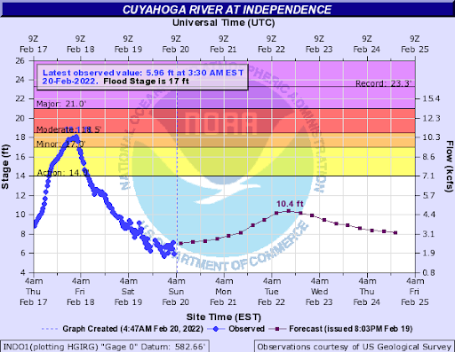 |
| Mahoning River at Warren | Mahoning River at Leavittsburg | Mahoning River at Youngstown | Cuyahoga River |
 |
 |
 |
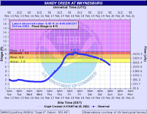 |
| Blanchard River at Findlay | Vermillion River near Mill Hollow MP | Nimishillen Creek at North Industry | Sandy Creek at Waynesburg |
 |
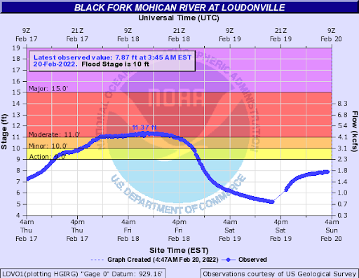 |
| Middle Branch Nimishillen Creek at Canton | Black Fork Mohican River at Loudonville |
Photos & Video
Video of ice jam floe through the Grand River in Painesville, OH
 |
 |
 |
 |
| Ice jams on the Grand River near St. Clair Street and Grand River Landing Park. | Another view of the ice jams on the Grand River near St. Clair Street and Grand River Landing Park. | Ice accumulation on trees in Fremont, OH. (Photo credit: Josh) |
Flooding as a result of an ice jam in Vermillion, OH on Riverside Dr. (Photo Credit: Bruce Bishop) |
Radar
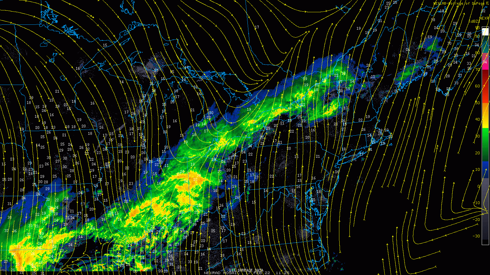 |
| Radar loop from 7 AM February 17 through 10 AM February 18, 2022. |
Storm Reports
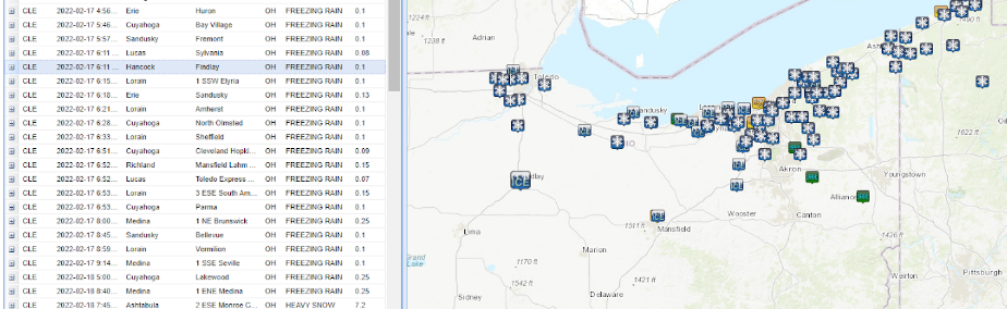
LSR reports from across the area. The table on the left includes the freezing rain reports we received, ranging anywhere from 0.10 to 0.25 inches of ice.
959
NOUS41 KCLE 190300
PNSCLE
OHZ003-006>014-017>023-027>033-036>038-047-089-PAZ001>003-191500-

Public Information Statement
Spotter Reports
National Weather Service Cleveland OH
1000 PM EST Fri Feb 18 2022

The following are unofficial observations taken during the past 9
hours for the storm that affected our region yesterday and today.
Appreciation is extended to highway departments, cooperative
observers, Skywarn spotters, and media for these reports. This
summary also is available on our home page at weather.gov/cleveland

********************STORM TOTAL SNOWFALL********************

LOCATION                TOTAL      TIME/DATE  COMMENTS
                     SNOWFALL       MEASURED
                     (inches)

OHIO

...Ashtabula County...
  3 E South Madison       5.9   719 PM  2/18  Trained Spotter
  3 ENE Trumbull          5.5   739 PM  2/18  Trained Spotter
  2 ESE Pierpont          5.5   920 PM  2/18  Trained Spotter
  1 E Orwell              1.7   810 PM  2/18  Trained Spotter

...Cuyahoga County...
  1 W Chagrin Falls       4.7   630 PM  2/18  Trained Spotter
  2 SW Cleveland Heigh    3.9   600 PM  2/18  Trained Spotter
  Westlake                3.4   800 PM  2/18  Trained Spotter
  Seven Hills             3.4   500 PM  2/18  Trained Spotter
  1 ESE Broadview Heig    3.1   650 PM  2/18  Trained Spotter
  1 WSW Cleveland Heig    2.5   740 PM  2/18  Trained Spotter

...Geauga County...
  3 WSW Auburn Corners    4.7   700 PM  2/18  Trained Spotter
  1 S Montville           4.4   700 PM  2/18  Trained Spotter
  2 W Burton              3.4   600 PM  2/18  Trained Spotter

...Lake County...
  1 SE Concord            6.9   730 PM  2/18  Trained Spotter
  1 WSW Madison           4.2   700 PM  2/18  Trained Spotter
  1 NNE Kirtland Hills    3.6   730 PM  2/18  Trained Spotter
  2 WNW Concord           3.3   900 PM  2/18  Trained Spotter

...Medina County...
  2 ESE Hinckley          2.3   645 PM  2/18  Trained Spotter

...Summit County...
  1 N Bath                3.2   700 PM  2/18  Trained Spotter
  1 NW Tallmadge          1.7   800 PM  2/18  Trained Spotter

PENNSYLVANIA

...Erie County...
  4 SE Harborcreek        7.0   640 PM  2/18  Trained Spotter
  2 ESE North East        5.5   700 PM  2/18  Trained Spotter
  2 NW Edinboro           5.0   430 PM  2/18  Trained Spotter
  2 ESE Erie              4.0   645 PM  2/18  Trained Spotter
  2 E Edinboro            3.6   700 PM  2/18  Trained Spotter


**********************12 HOUR SNOWFALL**********************

LOCATION              12 HOUR      TIME/DATE  COMMENTS
                     SNOWFALL       MEASURED
                     (inches)

OHIO

...Ashtabula County...
  3 E South Madison       1.7   719 PM  2/18  Trained Spotter
  2 ESE Pierpont          1.5   920 PM  2/18  Trained Spotter
  2 N Cherry Valley       1.4   625 PM  2/18  Trained Spotter
  3 ENE Trumbull          1.0   739 PM  2/18  Trained Spotter
  1 E Orwell              0.5   810 PM  2/18  Trained Spotter

...Cuyahoga County...
  2 SW Cleveland Heigh    1.8   600 PM  2/18  Trained Spotter
  1 W Chagrin Falls       1.2   630 PM  2/18  Trained Spotter
  1 WSW Cleveland Heig    1.0   740 PM  2/18  Trained Spotter
  1 W Shaker Heights      1.0   930 PM  2/18  Trained Spotter
  Seven Hills             1.0   500 PM  2/18  Trained Spotter
  Westlake                0.6   800 PM  2/18  Trained Spotter
  1 ESE Broadview Heig    0.5   650 PM  2/18  Trained Spotter
  Cleveland Hopkins Ai    0.1   700 PM  2/18  Trained Spotter

...Geauga County...
  2 W South Thompson      1.8   500 PM  2/18  Trained Spotter
  3 WSW Auburn Corners    1.8   700 PM  2/18  Trained Spotter
  1 S Montville           1.8   700 PM  2/18  Trained Spotter
  2 W Burton              1.0   600 PM  2/18  Trained Spotter
  3 SW Chardon            1.0   930 PM  2/18  Trained Spotter

...Holmes County...
  4 E Killbuck            0.3   530 PM  2/18  Trained Spotter

...Lake County...
  1 WSW Madison           3.2   700 PM  2/18  Trained Spotter
  2 S Waite Hill          2.0   700 PM  2/18  Trained Spotter
  1 NNE Kirtland Hills    1.5   730 PM  2/18  Trained Spotter
  1 SE Concord            1.4   730 PM  2/18  Trained Spotter
  2 WNW Concord           0.6   900 PM  2/18  Trained Spotter
  Willoughby              0.3   800 PM  2/18  Trained Spotter

...Lucas County...
  Toledo Express Airpo      T   700 PM  2/18  Trained Spotter

...Medina County...
  2 ESE Hinckley          0.7   645 PM  2/18  Trained Spotter

...Portage County...
  Hiram                   0.3   800 PM  2/18  Trained Spotter
  1 ENE Mogadore          0.1   800 PM  2/18  Trained Spotter

...Richland County...
  Mansfield Lahm Airpo      T   700 PM  2/18  Trained Spotter

...Stark County...
  4 S Alliance            1.0   600 PM  2/18  Trained Spotter

...Summit County...
  1 N Bath                2.6   700 PM  2/18  Trained Spotter
  1 NW Tallmadge          0.5   800 PM  2/18  Trained Spotter
  Akron-Canton Airport    0.2   700 PM  2/18  Trained Spotter

...Trumbull County...
  Youngstown Regional     0.1   700 PM  2/18  Trained Spotter

...Wood County...
  2 WSW Bowling Green       T   825 PM  2/18  Trained Spotter

PENNSYLVANIA

...Crawford County...
  3 NE Cochranton         0.5   800 PM  2/18  Trained Spotter

...Erie County...
  4 SE Harborcreek        2.0   640 PM  2/18  Trained Spotter
  2 E Edinboro            1.4   700 PM  2/18  Trained Spotter
  1 WNW Cherry Hill       1.2   720 PM  2/18  Trained Spotter
  4 S Wesleyville         1.0   730 PM  2/18  Trained Spotter
  2 NW Edinboro           1.0   430 PM  2/18  Trained Spotter
  2 ESE Erie              0.6   645 PM  2/18  Trained Spotter
  Erie Intl Airport       0.5   700 PM  2/18  Trained Spotter
  1 NNW Girard              T   430 PM  2/18  Trained Spotter


**********************24 HOUR SNOWFALL**********************

LOCATION              24 HOUR      TIME/DATE  COMMENTS
                     SNOWFALL       MEASURED
                     (inches)

OHIO

...Ashtabula County...
  2 S Harpersfield        4.0   248 PM  2/18  Trained Spotter

...Hancock County...
  WSW Findlay             1.0   345 PM  2/18  CoCoRaHS

&&

*****METADATA*****
:2/18/2022,  719 PM, OH, Ashtabula, South Madison, 3, E, 41.72600, -80.99100, SNOW, 5.9, Inch, Trained Spotter, Storm Total Snow,
:2/18/2022,  739 PM, OH, Ashtabula, Trumbull, 3, ENE, 41.69720, -80.90560, SNOW, 5.5, Inch, Trained Spotter, Storm Total Snow,
:2/18/2022,  920 PM, OH, Ashtabula, Pierpont, 2, ESE, 41.73940, -80.54630, SNOW, 5.5, Inch, Trained Spotter, Storm Total Snow,
:2/18/2022,  810 PM, OH, Ashtabula, Orwell, 1, E, 41.53570, -80.83330, SNOW, 1.7, Inch, Trained Spotter, Storm Total Snow,
:2/18/2022,  630 PM, OH, Cuyahoga, Chagrin Falls, 1, W, 41.43300, -81.40970, SNOW, 4.7, Inch, Trained Spotter, Storm Total Snow,
:2/18/2022,  600 PM, OH, Cuyahoga, Cleveland Heights, 2, SW, 41.49480, -81.58670, SNOW, 3.9, Inch, Trained Spotter, Storm Total Snow,
:2/18/2022,  800 PM, OH, Cuyahoga, Westlake, , , 41.44800, -81.93260, SNOW, 3.4, Inch, Trained Spotter, Storm Total Snow,
:2/18/2022,  500 PM, OH, Cuyahoga, Seven Hills, , , 41.37900, -81.66980, SNOW, 3.4, Inch, Trained Spotter, Storm Total Snow,
:2/18/2022,  650 PM, OH, Cuyahoga, Broadview Heights, 1, ESE, 41.31160, -81.66150, SNOW, 3.1, Inch, Trained Spotter, Storm Total Snow,
:2/18/2022,  740 PM, OH, Cuyahoga, Cleveland Heights, 1, WSW, 41.50200, -81.58390, SNOW, 2.5, Inch, Trained Spotter, Storm Total Snow,
:2/18/2022,  700 PM, OH, Geauga, Auburn Corners, 3, WSW, 41.36270, -81.26990, SNOW, 4.7, Inch, Trained Spotter, Storm Total Snow,
:2/18/2022,  700 PM, OH, Geauga, Montville, 1, S, 41.59040, -81.04760, SNOW, 4.4, Inch, Trained Spotter, Storm Total Snow,
:2/18/2022,  600 PM, OH, Geauga, Burton, 2, W, 41.47270, -81.18350, SNOW, 3.4, Inch, Trained Spotter, Storm Total Snow,
:2/18/2022,  730 PM, OH, Lake, Concord, 1, SE, 41.66130, -81.20840, SNOW, 6.9, Inch, Trained Spotter, Storm Total Snow,
:2/18/2022,  700 PM, OH, Lake, Madison, 1, WSW, 41.76850, -81.06990, SNOW, 4.2, Inch, Trained Spotter, Storm Total Snow,
:2/18/2022,  730 PM, OH, Lake, Kirtland Hills, 1, NNE, 41.65220, -81.30970, SNOW, 3.6, Inch, Trained Spotter, Storm Total Snow,
:2/18/2022,  900 PM, OH, Lake, Concord, 2, WNW, 41.68070, -81.26540, SNOW, 3.3, Inch, Trained Spotter, Storm Total Snow,
:2/18/2022,  645 PM, OH, Medina, Hinckley, 2, ESE, 41.22880, -81.71600, SNOW, 2.3, Inch, Trained Spotter, Storm Total Snow,
:2/18/2022,  700 PM, OH, Summit, Bath, 1, N, 41.20190, -81.63420, SNOW, 3.2, Inch, Trained Spotter, Storm Total Snow,
:2/18/2022,  800 PM, OH, Summit, Tallmadge, 1, NW, 41.11800, -81.43810, SNOW, 1.7, Inch, Trained Spotter, Storm Total Snow,
:2/18/2022,  640 PM, PA, Erie, Harborcreek, 4, SE, 42.12730, -79.89500, SNOW, 7.0, Inch, Trained Spotter, Storm Total Snow,
:2/18/2022,  700 PM, PA, Erie, North East, 2, ESE, 42.20020, -79.80210, SNOW, 5.5, Inch, Trained Spotter, Storm Total Snow,
:2/18/2022,  430 PM, PA, Erie, Edinboro, 2, NW, 41.89670, -80.15670, SNOW, 5.0, Inch, Trained Spotter, Storm Total Snow,
:2/18/2022,  645 PM, PA, Erie, Erie, 2, ESE, 42.11130, -80.05100, SNOW, 4.0, Inch, Trained Spotter, Storm Total Snow,
:2/18/2022,  700 PM, PA, Erie, Edinboro, 2, E, 41.87170, -80.08500, SNOW, 3.6, Inch, Trained Spotter, Storm Total Snow,
:2/18/2022,  719 PM, OH, Ashtabula, South Madison, 3, E, 41.72600, -80.99100, SNOW_12, 1.7, Inch, Trained Spotter, 12-hourly Snowfall,
:2/18/2022,  920 PM, OH, Ashtabula, Pierpont, 2, ESE, 41.73940, -80.54630, SNOW_12, 1.5, Inch, Trained Spotter, 12-hourly Snowfall,
:2/18/2022,  625 PM, OH, Ashtabula, Cherry Valley, 2, N, 41.63460, -80.66140, SNOW_12, 1.4, Inch, Trained Spotter, 12-hourly Snowfall,
:2/18/2022,  739 PM, OH, Ashtabula, Trumbull, 3, ENE, 41.69720, -80.90560, SNOW_12, 1.0, Inch, Trained Spotter, 12-hourly Snowfall,
:2/18/2022,  810 PM, OH, Ashtabula, Orwell, 1, E, 41.53570, -80.83330, SNOW_12, 0.5, Inch, Trained Spotter, 12-hourly Snowfall,
:2/18/2022,  600 PM, OH, Cuyahoga, Cleveland Heights, 2, SW, 41.49480, -81.58670, SNOW_12, 1.8, Inch, Trained Spotter, 12-hourly Snowfall,
:2/18/2022,  630 PM, OH, Cuyahoga, Chagrin Falls, 1, W, 41.43300, -81.40970, SNOW_12, 1.2, Inch, Trained Spotter, 12-hourly Snowfall,
:2/18/2022,  740 PM, OH, Cuyahoga, Cleveland Heights, 1, WSW, 41.50200, -81.58390, SNOW_12, 1.0, Inch, Trained Spotter, 12-hourly Snowfall,
:2/18/2022,  930 PM, OH, Cuyahoga, Shaker Heights, 1, W, 41.47460, -81.56870, SNOW_12, 1.0, Inch, Trained Spotter, 12-hourly Snowfall,
:2/18/2022,  500 PM, OH, Cuyahoga, Seven Hills, , , 41.37900, -81.66980, SNOW_12, 1.0, Inch, Trained Spotter, 12-hourly Snowfall,
:2/18/2022,  800 PM, OH, Cuyahoga, Westlake, , , 41.44800, -81.93260, SNOW_12, 0.6, Inch, Trained Spotter, 12-hourly Snowfall,
:2/18/2022,  650 PM, OH, Cuyahoga, Broadview Heights, 1, ESE, 41.31160, -81.66150, SNOW_12, 0.5, Inch, Trained Spotter, 12-hourly Snowfall,
:2/18/2022,  700 PM, OH, Cuyahoga, Cleveland Hopkins Airport, , , 41.40190, -81.84790, SNOW_12, 0.1, Inch, Trained Spotter, 12-hourly Snowfall,
:2/18/2022,  500 PM, OH, Geauga, South Thompson, 2, W, 41.64390, -81.09020, SNOW_12, 1.8, Inch, Trained Spotter, 12-hourly Snowfall,
:2/18/2022,  700 PM, OH, Geauga, Auburn Corners, 3, WSW, 41.36270, -81.26990, SNOW_12, 1.8, Inch, Trained Spotter, 12-hourly Snowfall,
:2/18/2022,  700 PM, OH, Geauga, Montville, 1, S, 41.59040, -81.04760, SNOW_12, 1.8, Inch, Trained Spotter, 12-hourly Snowfall,
:2/18/2022,  600 PM, OH, Geauga, Burton, 2, W, 41.47270, -81.18350, SNOW_12, 1.0, Inch, Trained Spotter, 12-hourly Snowfall,
:2/18/2022,  930 PM, OH, Geauga, Chardon, 3, SW, 41.54560, -81.24420, SNOW_12, 1.0, Inch, Trained Spotter, 12-hourly Snowfall,
:2/18/2022,  530 PM, OH, Holmes, Killbuck, 4, E, 40.48830, -81.90980, SNOW_12, 0.3, Inch, Trained Spotter, 12-hourly Snowfall,
:2/18/2022,  700 PM, OH, Lake, Madison, 1, WSW, 41.76850, -81.06990, SNOW_12, 3.2, Inch, Trained Spotter, 12-hourly Snowfall,
:2/18/2022,  700 PM, OH, Lake, Waite Hill, 2, S, 41.57980, -81.37750, SNOW_12, 2.0, Inch, Trained Spotter, 12-hourly Snowfall,
:2/18/2022,  730 PM, OH, Lake, Kirtland Hills, 1, NNE, 41.65220, -81.30970, SNOW_12, 1.5, Inch, Trained Spotter, 12-hourly Snowfall,
:2/18/2022,  730 PM, OH, Lake, Concord, 1, SE, 41.66130, -81.20840, SNOW_12, 1.4, Inch, Trained Spotter, 12-hourly Snowfall,
:2/18/2022,  900 PM, OH, Lake, Concord, 2, WNW, 41.68070, -81.26540, SNOW_12, 0.6, Inch, Trained Spotter, 12-hourly Snowfall,
:2/18/2022,  800 PM, OH, Lake, Willoughby, , , 41.64030, -81.41170, SNOW_12, 0.3, Inch, Trained Spotter, 12-hourly Snowfall,
:2/18/2022,  700 PM, OH, Lucas, Toledo Express Airport, , , 41.59240, -83.80520, SNOW_12, T, Inch, Trained Spotter, 12-hourly Snowfall,
:2/18/2022,  645 PM, OH, Medina, Hinckley, 2, ESE, 41.22880, -81.71600, SNOW_12, 0.7, Inch, Trained Spotter, 12-hourly Snowfall,
:2/18/2022,  800 PM, OH, Portage, Hiram, , , 41.31510, -81.14340, SNOW_12, 0.3, Inch, Trained Spotter, 12-hourly Snowfall,
:2/18/2022,  800 PM, OH, Portage, Mogadore, 1, ENE, 41.05250, -81.38830, SNOW_12, 0.1, Inch, Trained Spotter, 12-hourly Snowfall,
:2/18/2022,  700 PM, OH, Richland, Mansfield Lahm Airport, , , 40.81300, -82.51610, SNOW_12, T, Inch, Trained Spotter, 12-hourly Snowfall,
:2/18/2022,  600 PM, OH, Stark, Alliance, 4, S, 40.85700, -81.12460, SNOW_12, 1.0, Inch, Trained Spotter, 12-hourly Snowfall,
:2/18/2022,  700 PM, OH, Summit, Bath, 1, N, 41.20190, -81.63420, SNOW_12, 2.6, Inch, Trained Spotter, 12-hourly Snowfall,
:2/18/2022,  800 PM, OH, Summit, Tallmadge, 1, NW, 41.11800, -81.43810, SNOW_12, 0.5, Inch, Trained Spotter, 12-hourly Snowfall,
:2/18/2022,  700 PM, OH, Summit, Akron-Canton Airport, , , 40.91670, -81.43540, SNOW_12, 0.2, Inch, Trained Spotter, 12-hourly Snowfall,
:2/18/2022,  700 PM, OH, Trumbull, Youngstown Regional Airport, , , 41.25740, -80.66700, SNOW_12, 0.1, Inch, Trained Spotter, 12-hourly Snowfall,
:2/18/2022,  825 PM, OH, Wood, Bowling Green, 2, WSW, 41.36470, -83.68880, SNOW_12, T, Inch, Trained Spotter, 12-hourly Snowfall,
:2/18/2022,  800 PM, PA, Crawford, Cochranton, 3, NE, 41.55580, -80.00960, SNOW_12, 0.5, Inch, Trained Spotter, 12-hourly Snowfall,
:2/18/2022,  640 PM, PA, Erie, Harborcreek, 4, SE, 42.12730, -79.89500, SNOW_12, 2.0, Inch, Trained Spotter, 12-hourly Snowfall,
:2/18/2022,  700 PM, PA, Erie, Edinboro, 2, E, 41.87170, -80.08500, SNOW_12, 1.4, Inch, Trained Spotter, 12-hourly Snowfall,
:2/18/2022,  720 PM, PA, Erie, Cherry Hill, 1, WNW, 41.91720, -80.46820, SNOW_12, 1.2, Inch, Trained Spotter, 12-hourly Snowfall,
:2/18/2022,  730 PM, PA, Erie, Wesleyville, 4, S, 42.08010, -80.01430, SNOW_12, 1.0, Inch, Trained Spotter, 12-hourly Snowfall,
:2/18/2022,  430 PM, PA, Erie, Edinboro, 2, NW, 41.89670, -80.15670, SNOW_12, 1.0, Inch, Trained Spotter, 12-hourly Snowfall,
:2/18/2022,  645 PM, PA, Erie, Erie, 2, ESE, 42.11130, -80.05100, SNOW_12, 0.6, Inch, Trained Spotter, 12-hourly Snowfall,
:2/18/2022,  700 PM, PA, Erie, Erie Intl Airport, , , 42.08160, -80.17780, SNOW_12, 0.5, Inch, Trained Spotter, 12-hourly Snowfall,
:2/18/2022,  430 PM, PA, Erie, Girard, 1, NNW, 42.01310, -80.32760, SNOW_12, T, Inch, Trained Spotter, 12-hourly Snowfall,
:2/18/2022,  248 PM, OH, Ashtabula, Harpersfield, 2, S, 41.72990, -80.94760, SNOW_24, 4.0, Inch, Trained Spotter, 24-hourly Snowfall,
:2/18/2022,  345 PM, OH, Hancock, Findlay, , WSW, 41.04010, -83.64920, SNOW_24, 1.0, Inch, CoCoRaHS, 24-hourly Snowfall,

$$

Sullivan
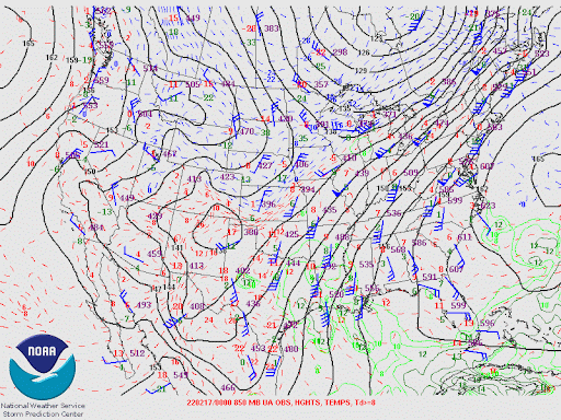
Environment
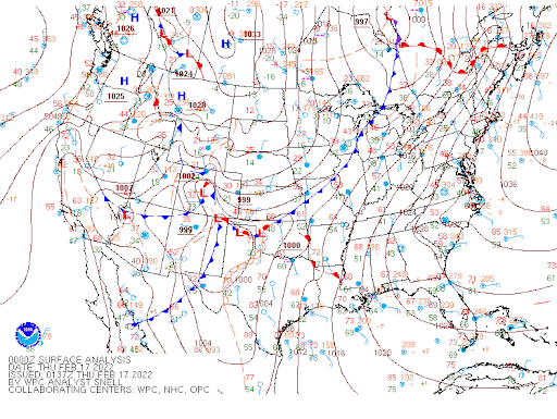 |
 |
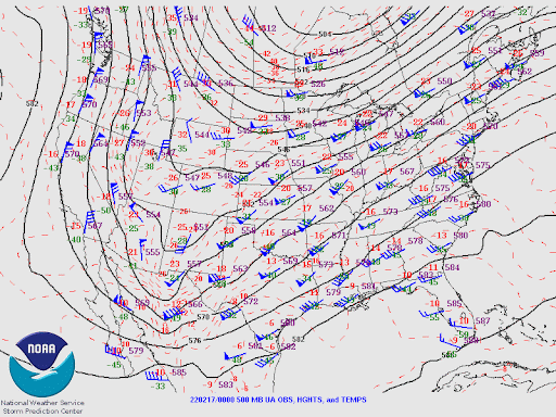 |
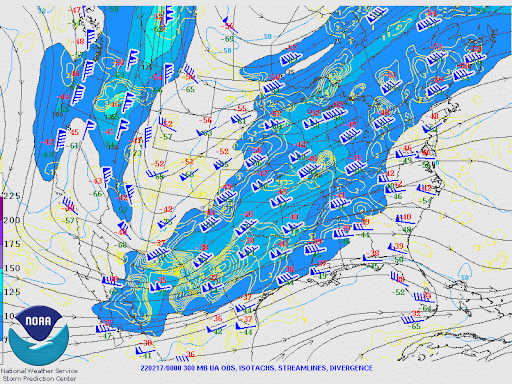 |
| WPC surface analysis loop ending 4 PM Feb 18, 2022. | 850 mb map loop ending 7 AM Feb 18, 2022. | 500 mb map loop ending 7 AM Feb 18, 2022. | 300 mb map loop ending 7 AM Feb 18, 2022. |
.
 |
Media use of NWS Web News Stories is encouraged! Please acknowledge the NWS as the source of any news information accessed from this site. |
|