Overview
|
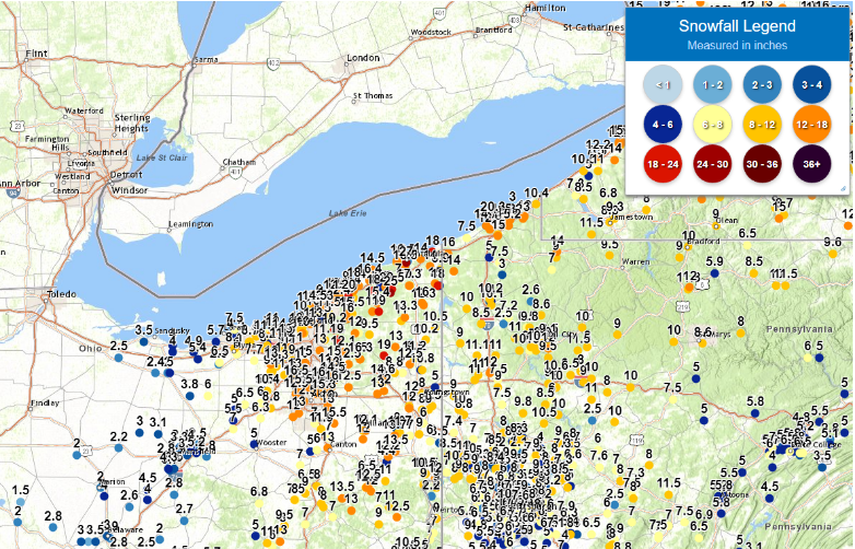
A deepening low pressure associated with a strong, closed-off 500mb low moved from the central Gulf Coast to central PA Sunday and Sunday night, taking an unusual track across the spine of the Appalachians. The low pressure bottomed out at a central pressure of approximately 980mb over central PA Monday morning. This placed the eastern â…” of Ohio and western PA in the area of snowfall on the northwest side of the storm Sunday evening into Monday, with snow only slowly departing the Snowbelt on Monday as lake enhancement contributed to continued heavy snowfall there well into the day. The combination of the storm's size, track, intensity, and amount of moisture led to a heavy snow event for all of Northeast Ohio and Northwest PA, dropping off to no snow towards Northwest Ohio. Eastern Ohio and western Pennsylvania were sandwiched between warmer and more humid mid-level air drawn up east of the storm and colder, drier air being pulled in from the west. This tightening temperature gradient aloft (known as frontogenesis), along with strong easterly flow aloft bringing in Atlantic moisture contributed to heavy snowfall across eastern Ohio and western Pennsylvania. The atmosphere was less stable than it usually is in a winter storm situation, which contributed to several hours of heavy banded snow over Northeast Ohio and Northwestern PA overnight Sunday night into early Monday morning. Snowfall rates of 1-2” per hour were common in this banded snow and lingered well into Monday in the Snowbelt of Northeast Ohio and Northwest PA as the departing system snow became enhanced by the lake. These prolonged heavy rates made roads nearly impassable in many areas come Monday morning. KCLE, KCAK, and KYNG all have weather observers that provide hourly (or more often as needed) weather observations, and all of these airports had 1-2” per hour snow rates reported for a several hour period late Sunday evening through early Monday morning. The snow was initially wet Sunday evening, with some brief mixed precipitation occurring in parts of eastern Ohio and PA. The snow became fluffier into Monday morning, with winds turning gusty into Monday and causing blowing and drifting. Where lake enhanced snow continued well into Monday in the Snowbelt, totals of over 2 feet occurred. Totals into the Cleveland, Akron, and Youngstown areas were commonly 12-18”, with a fairly sharp drop off occurring from Lorain, Medina, Wayne and Holmes Counties points west. |
|
Photos & Video
 |
 |
 |
 |
| Twinsburg, OH on January 17 Photo Credit: Doneka Etteyan |
Cleveland, OH on January 17 Photo Credit: Twitter/j_nejman11 |
Downtown Cleveland on January 17 Photo Credit: Nadeen Abusada |
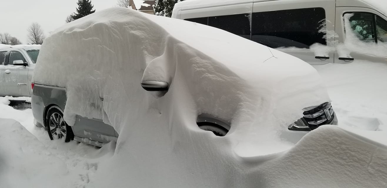
Car buried in snow in Conneaut, OH on January 17 Photo Credit: Renae DeWalt Picard |
 |
 |
 |
 |
| A news van buried in falling and drifting snow in Erie on Jan 17 Photo Credit: David Wolter |
Erie, PA neighborhood streets still buried in snow on Jan 18 Photo Credit: Twitter/LisaADonoghue3 |
A snowy and barren downtown Cleveland on January 17 Photo Credit: Nadeen Abusada |
An RTA bus stuck in the snow in downtown Cleveland on Jan 17 Photo Credit: Nadeen Abusadad |
 |
 |
| Paving a pathway through deep snow in Concord Township, OH on Jan 18 Photo Credit: Jan Rose | Deep snow covering a driveway in Concord Township, OH on Jan 17 Photo Credit: Jan Rose |
Radar
 |
| Radar loop from 3 PM EST Jan 16 to 3 PM EST Jan 17, 2022. |
Storm Reports
802
NOUS41 KCLE 191608
PNSCLE
OHZ003-006>014-017>023-027>033-036>038-047-089-PAZ001>003-190555-

Public Information Statement...Corrected storm total for a couple sites
Spotter Reports
National Weather Service Cleveland OH
543 PM EST Tue Jan 18 2022

...Final Storm Total Snow Amounts from January 16-17 Winter Storm...

The following are unofficial observations taken during the past 43
hours for the storm that has been affecting our region. Appreciation
is extended to highway departments, cooperative observers, Skywarn
spotters, and media for these reports. This summary also is available
on our home page at weather.gov/cleveland

********************STORM TOTAL SNOWFALL********************

LOCATION                TOTAL      TIME/DATE  COMMENTS
                     SNOWFALL       MEASURED
                     (inches)

OHIO

...Ashland County...
  3 NW Loudonville        6.2   700 AM  1/17  CoCoRaHS
  4 SW Ashland            4.0   700 AM  1/18  CoCoRaHS
  3 WSW Hayesville        2.8   730 AM  1/17  Trained Spotter

...Ashtabula County...
  1 SSE Ashtabula        28.0   700 AM  1/17  CoCoRaHS
  3 E South Madison      27.3   827 PM  1/17  Trained Spotter
  2 ESE Monroe Center    27.2   630 PM  1/17  Trained Spotter
  3 ENE Trumbull         25.0   230 PM  1/17  Trained Spotter
  2 S Ashtabula          24.0   555 PM  1/17  Trained Spotter
  4 SE Harpersfield       22.5   812 AM  1/17  Trained Spotter
  3 W Ashtabula          22.0   630 PM  1/17  Trained Spotter
  1 ESE Ashtabula        21.7   954 AM  1/17  Trained Spotter
  1 ENE Jefferson         21.7   500 PM  1/17  Trained Spotter
  3 NW Colebrook         20.3   830 PM  1/17  Trained Spotter
  1 SSE Kelloggsville    20.0   730 PM  1/17  Trained Spotter
  2 ESE Pierpont         18.5   800 AM  1/18  Trained Spotter
  2 NNW Cherry Valley    18.0   900 AM  1/18  Trained Spotter
  1 WSW Conneaut         18.0   845 AM  1/17  Trained Spotter
  3 NNE Saybrook         18.0   655 PM  1/17  Trained Spotter
  Jefferson               17.3   700 AM  1/17  Social Media
  2 N Cherry Valley      17.2   515 PM  1/17  Trained Spotter
  Rock Creek             17.0   636 AM  1/17  Broadcast Media
  Pierpont               15.0   555 AM  1/17  Social Media
  Kingsville             14.0   555 AM  1/17  Social Media
  1 E Orwell             12.7   815 PM  1/17  Trained Spotter
  Austinburg              7.0   200 AM  1/17  Social Media

...Crawford County...
  3 WSW Tiro              3.0   740 AM  1/17  Trained Spotter
  1 NW Bucyrus            2.2   900 AM  1/17  CoCoRaHS

...Cuyahoga County...
  2 NE Euclid            16.0   900 PM  1/17  Trained Spotter
  2 SW Cleveland Heigh   15.5   600 PM  1/17  Trained Spotter
  1 W Chagrin Falls      15.2   825 PM  1/17  Trained Spotter
  Cleveland-Old Brookl   15.0  1008 AM  1/17  Trained Spotter
  1 ENE Lyndhurst        15.0   803 PM  1/17  Trained Spotter
  2 W Shaker Heights     14.0   800 AM  1/18  CoCoRaHS
  1 SE Strongsville      13.5   800 AM  1/18  CoCoRaHS
  Parma                  13.5   326 AM  1/17  Social Media
  1 NNE Seven Hills      13.3   700 AM  1/18  CoCoRaHS
  ESE South Euclid       13.3   830 AM  1/18  CoCoRaHS
  2 NNW Parma            13.2   800 AM  1/18  CoCoRaHS
  1 SSW Solon            13.0   956 AM  1/17  Trained Spotter
  1 W Shaker Heights     13.0   600 PM  1/17  Trained Spotter
  2 WSW Seven Hills      13.0  1000 AM  1/17  Trained Spotter
  1 WSW Cleveland Heig   12.5   715 PM  1/17  Trained Spotter
  2 NNW Euclid           12.5   900 PM  1/17  Trained Spotter
  1 NNE North Royalton   12.3  1020 AM  1/17  Trained Spotter
  2 WSW Brooklyn Heigh   12.0   700 PM  1/17  Trained Spotter
  1 SSW Lakewood         12.0   700 AM  1/17  CoCoRaHS
  1 NW Lakewood          11.8   845 AM  1/17  Trained Spotter
  2 SE Brecksville       11.5   700 AM  1/18  CoCoRaHS
  2 SSW Rocky River      11.3   800 AM  1/17  CoCoRaHS
  1 ESE Broadview Heig   11.2   710 PM  1/17  Trained Spotter
  Seven Hills            10.1   700 AM  1/17  Trained Spotter
  Bratenahl              10.0   628 AM  1/17  Social Media
  1 SSW Westlake          9.3   800 AM  1/18  CoCoRaHS
  Westlake                9.3   800 PM  1/17  Trained Spotter
  Cleveland Hopkins Ai    9.2   700 AM  1/17  Trained Spotter
  1 NW Berea              9.0   600 AM  1/18  CoCoRaHS
  Rocky River             7.0   555 AM  1/17  Social Media

...Erie County...
  N Berlin Heights        5.4   700 AM  1/17  CoCoRaHS
  5 NNE Wakeman           5.4   800 AM  1/17  CoCoRaHS
  ENE Milan               4.8   800 AM  1/17  CoCoRaHS
  Huron                   4.0   800 AM  1/17  Trained Spotter
  3 SSW Huron             4.0   800 AM  1/17  CoCoRaHS
  2 NNE Castalia          4.0   635 AM  1/18  CoCoRaHS

...Geauga County...
  2 SE South Madison     28.0   100 PM  1/17  Storm total = 28 inches
  4 S Madison            23.0   700 AM  1/18  CoCoRaHS
  2 ESE South Thompson   21.2   850 PM  1/17  Trained Spotter
  1 S Montville          20.5   600 PM  1/17  Trained Spotter
  3 ESE Montville        20.5   735 PM  1/17  Trained Spotter
  3 SW Chardon           19.3   800 AM  1/18  Trained Spotter
  3 WSW Auburn Corners   19.2   815 AM  1/18  Trained Spotter
  2 W Burton             19.2   430 PM  1/17  Trained Spotter
  Novelty                19.2   900 AM  1/17  Broadcast Media
  1 NE Middlefield        11.5   800 AM  1/18  CoCoRaHS

...Holmes County...
  4 E Killbuck           10.3   515 PM  1/17  Trained Spotter

...Huron County...
  1 E Norwalk             5.0   830 AM  1/17  CoCoRaHS
  3 NW New London         4.6   545 PM  1/17  Trained Spotter
  Monroeville             2.4  1249 AM  1/17  Social Media
  Norwalk                 2.0  1231 AM  1/17  Social Media
  1 N Bellevue            1.5   600 AM  1/17  CoCoRaHS

...Knox County...
  4 NNW Fredericktown     2.8   700 AM  1/17  CoCoRaHS
  WNW Mount Vernon        2.7   816 AM  1/17  CoCoRaHS
  2 SE Centerburg         2.0   800 AM  1/17  Co-Op Observer

...Lake County...
  2 S Waite Hill         23.1   700 PM  1/17  Trained Spotter
  1 WSW Madison          22.1   600 PM  1/17  Trained Spotter
  1 NW Concord           21.7   700 PM  1/17  Trained Spotter
  1 SE Concord           20.3   730 PM  1/17  Trained Spotter
  3 WSW Perry            18.0   800 AM  1/17  Trained Spotter
  North Madison          17.0   650 PM  1/17  Trained Spotter
  2 ESE Mentor           16.9   715 AM  1/18  Trained Spotter
  1 NNE Kirtland Hills   16.6   650 PM  1/17  Trained Spotter
  3 SW Willoughby        15.7   700 AM  1/18  CoCoRaHS
  2 SSW Perry            15.2   900 PM  1/17  Trained Spotter
  2 SSW Mentor-On-the-   14.5   930 PM  1/17  Trained Spotter
  1 SSE Wickliffe         14.2    700 PM  1/17  Trained Spotter
  3 ESE Painesville      14.0   940 AM  1/17  Trained Spotter
  Willoughby             13.2   800 AM  1/18  Trained Spotter
  1 SSE Mentor           13.1   900 PM  1/17  Trained Spotter
  1 E Mentor             12.5   750 AM  1/17  Trained Spotter
  Mentor                 11.0   555 AM  1/17  Social Media
  1 ENE Wickliffe         10.3    430 AM  1/17  Trained Spotter
  2 E Concord             9.0   148 AM  1/17  Social Media
  Painesville             9.0   458 AM  1/17  Social Media

...Lorain County...
  Columbia Station       13.4   325 AM  1/17  Social Media
  3 NE North Ridgevill    9.5   700 AM  1/18  CoCoRaHS
  2 NE North Ridgevill    9.0   700 AM  1/18  CoCoRaHS
  SE Elyria               8.2   710 AM  1/18  CoCoRaHS
  Sheffield Lake            7.5   926 AM  1/17  Public
  3 SE Elyria             6.5   800 AM  1/17  Trained Spotter
  1 NNE Oberlin           6.5   800 AM  1/17  CoCoRaHS
  4 N Lagrange            6.0   700 AM  1/17  Co-Op Observer
  6 SW Wellington         6.0   800 AM  1/17  CoCoRaHS
  Sheffield                 4.5  1252 AM  1/17  Social Media
  Oberlin                 2.5   236 AM  1/17  Social Media

...Mahoning County...
  1 NW Austintown        13.0   645 AM  1/17  Trained Spotter
  Craig Beach            12.0   530 AM  1/17  Social Media
  1 N Canfield            12.0   645 AM  1/17  CoCoRaHS
  Canfield                12.0   700 AM  1/17  Trained Spotter
  1 NNW Canfield          11.4   645 PM  1/17  Trained Spotter
  5 NE Salem             11.0   730 AM  1/17  CoCoRaHS
  2 NW Youngstown        10.0   849 AM  1/17  Trained Spotter
  1 NW Poland             9.0  1000 AM  1/17  Trained Spotter
  Struthers               8.5   413 AM  1/17  Social Media
  Boardman                8.0   350 AM  1/17  Broadcast Media
  North Lima              6.0  1230 AM  1/17  Social Media

...Marion County...
  4 SSE Marion            4.0   700 AM  1/17  CoCoRaHS
  Marion                  2.0   840 AM  1/17  Trained Spotter

...Medina County...
  2 ESE Hinckley         13.6   630 PM  1/17  Trained Spotter
  1 ENE Medina           10.8   730 AM  1/18  CoCoRaHS
  1 ENE Brunswick        10.2   700 PM  1/17  Trained Spotter
  1 NE Brunswick          9.7   700 AM  1/17  CoCoRaHS
  Brunswick               8.5   555 AM  1/17  NWS Employee
  2 N Lodi                7.5   800 AM  1/17  Trained Spotter
  Chippewa Lake           6.0   156 AM  1/17  Social Media
  Medina                  5.5  1237 AM  1/17  Social Media
  2 E Homerville          5.5   700 PM  1/17  Trained Spotter

...Morrow County...
  4 ENE Mount Gilead      6.3   945 AM  1/17  Trained Spotter
  5 ESE Mount Gilead      4.1   600 AM  1/18  CoCoRaHS
  2 SSW Cardington        2.7   840 AM  1/18  CoCoRaHS

...Ottawa County...
  3 N Gypsum              1.5   700 AM  1/17  Trained Spotter
  3 W Port Clinton        1.5   900 AM  1/17  CoCoRaHS

...Portage County...
  Streetsboro            23.0   555 AM  1/17  Social Media
  Hiram                  18.6   800 AM  1/18  Trained Spotter
  N Hiram                18.6   800 AM  1/18  CoCoRaHS
  4 NE Kent              18.3   800 AM  1/18  CoCoRaHS
  2 SSW Streetsboro      17.0   700 AM  1/18  CoCoRaHS
  1 NNW Mantua           16.5   700 AM  1/18  CoCoRaHS
  1 NNE Kent             16.0  1211 PM  1/17  Trained Spotter
  1 E Ravenna            15.5   710 AM  1/18  CoCoRaHS
  1 W Craig Beach        13.0   700 AM  1/17  Co-Op Observer
  1 ENE Mogadore         12.4   700 AM  1/17  Trained Spotter
  2 W Kent               12.1   700 AM  1/17  CoCoRaHS
  2 NW Streetsboro       11.9   715 AM  1/17  CoCoRaHS
  5 SE Mogadore          11.4   700 AM  1/17  CoCoRaHS

...Richland County...
  Ontario                 6.0   759 PM  1/17  Co-Op Observer
  7 ENE Mansfield          5.7   700 AM  1/18  CoCoRaHS
  1 ENE Lexington         4.8   700 AM  1/18  CoCoRaHS
  5 NW Mifflin              4.8   720 AM  1/17  Trained Spotter
  1 NW Lexington          4.6   800 AM  1/18  CoCoRaHS
  Mansfield Lahm Airpo     4.0   700 AM  1/17  Trained Spotter
  Lexington               3.7   730 AM  1/17  Trained Spotter
  4 E Mansfield            3.7  1000 AM  1/17  Trained Spotter
  1 WNW Shelby            3.6   900 AM  1/17  Trained Spotter
  1 W Mansfield            3.5   840 AM  1/17  Trained Spotter
  5 WSW Mansfield          2.8   800 AM  1/17  CoCoRaHS
  1 NNE Shelby            1.1  1159 PM  1/17  CoCoRaHS

...Sandusky County...
  2 N Clyde               2.5   609 AM  1/17  Social Media
  2 ENE Fremont           1.5   944 AM  1/17  CoCoRaHS
  1 ESE Ballville         1.2   700 AM  1/17  Trained Spotter

...Seneca County...
  5 SE Tiffin               3.0   700 AM  1/17  CoCoRaHS
  Fostoria                  T   859 AM  1/17  Trained Spotter

...Stark County...
  1 W Canton             19.0   951 AM  1/17  Trained Spotter
  4 S Alliance           15.0   600 PM  1/17  Trained Spotter
  1 ESE Alliance         13.5   550 PM  1/17  Trained Spotter
  Alliance               11.0   300 AM  1/17  Social Media
  1 E North Canton        7.0   355 AM  1/17  Trained Spotter
  Brewster                7.0  1245 AM  1/17  Social Media
  Louisville              6.8  1200 AM  1/17  Social Media
  Perry Heights           6.0  1258 AM  1/17  Social Media
  Massillon               5.0  1241 AM  1/17  Social Media

...Summit County...
  1 SE Sagamore Hills    19.3   530 PM  1/17  Trained Spotter
  1 NW Boston Heights    19.5   504 PM  1/17  Trained Spotter
  1 SW Munroe Falls      17.7   700 AM  1/18  Trained Spotter
  2 SE Cuyahoga Falls    17.4   745 PM  1/17  Trained Spotter
  Bath                   16.5  1200 PM  1/17  Trained Spotter
  2 NE Fairlawn          16.5   700 AM  1/17  Trained Spotter
  1 NNE Tallmadge        16.1   813 AM  1/18  CoCoRaHS
  1 W Stow               16.0   845 AM  1/17  Public
  1 N Bath               15.9   700 PM  1/17  Trained Spotter
  1 NW Tallmadge         15.7   800 PM  1/17  Trained Spotter
  2 W Akron              15.0   700 AM  1/18  CoCoRaHS
  Fairlawn               14.5   700 PM  1/17  Trained Spotter
  1 ESE Cuyahoga Falls   13.1   700 AM  1/18  CoCoRaHS
  Barberton              13.0   555 AM  1/17  Social Media
  Richfield               13.0   550 AM  1/17  Social Media
  Cuyahoga Falls         12.0   555 AM  1/17  Social Media
  Akron-Canton Airport   11.9   700 AM  1/17  Trained Spotter
  3 SSW Barberton        10.2   600 PM  1/17  Trained Spotter
  1 NNE Bath              9.0   700 PM  1/17  Trained Spotter
  Green                   7.0   149 AM  1/17  Social Media

...Trumbull County...
  2 NNW Southington      19.0   945 AM  1/17  Trained Spotter
  Cortland               16.0   640 PM  1/17  Trained Spotter
  1 N Newton Falls       15.6   700 AM  1/18  CoCoRaHS
  1 WNW Newton Falls     15.6   700 PM  1/17  Trained Spotter
  Newton Falls           14.0   137 AM  1/17  Social Media
  2 S Williamsfield       14.0   710 PM  1/17  Trained Spotter
  Bristolville           13.0   445 AM  1/17  Social Media
  Mosquito Creek Lake    12.5   700 AM  1/17  Co-Op Observer
  Youngstown Regional    11.9   700 AM  1/17  Trained Spotter
  3 SE Gustavus          10.2   800 AM  1/17  Trained Spotter
  Warren                  7.0   110 AM  1/17  Social Media
  Hubbard                 5.0  1241 AM  1/17  Social Media

...Wayne County...
  3 ENE Doylestown       13.5   700 PM  1/17  Trained Spotter
  Creston                 7.3   645 PM  1/17  Trained Spotter
  W Mount Eaton           6.5   900 AM  1/17  CoCoRaHS
  West Salem              5.5   135 AM  1/17  Social Media
  1 NW Wooster            5.0   730 AM  1/17  Trained Spotter

...Wood County...
  2 WSW Bowling Green       T   939 PM  1/17  Trained Spotter

...Wyandot County...
  4 NW Harpster           2.0   800 AM  1/17  Trained Spotter

PENNSYLVANIA

...Crawford County...
  4 WNW Crossingville    20.0   700 PM  1/17  Trained Spotter
  1 S Meadville          17.9  1015 AM  1/18  Trained Spotter
  3 WNW Springboro       17.8   700 AM  1/18  CoCoRaHS
  1 WNW Conneaut Lake    15.9   700 AM  1/18  CoCoRaHS
  1 NNE Meadville        15.5   800 PM  1/17  Trained Spotter
  Cochranton             15.2   800 AM  1/17  Trained Spotter
  1 N Meadville          15.0   840 AM  1/17  Trained Spotter
  6 E Atlantic           14.5   830 AM  1/18  Trained Spotter
  3 NE Cochranton        12.2   800 AM  1/18  Trained Spotter
  7 NW Meadville          9.5   700 AM  1/17  CoCoRaHS

...Erie County...
  2 WSW Erie             25.5   620 AM  1/18  Trained Spotter
  2 ESE Erie             24.7   650 AM  1/18  Trained Spotter
  4 ESE Erie             23.9   700 AM  1/18  CoCoRaHS
  3 ENE McKean           23.0   700 PM  1/17  Trained Spotter
  4 S Wesleyville        22.7   700 PM  1/17  Trained Spotter
  4 SE Harborcreek       22.0   515 PM  1/17  Trained Spotter
  1 WNW Cherry Hill      21.9   715 AM  1/18  Trained Spotter
  4 W Colt Station       18.5   700 PM  1/17  Trained Spotter
  6 SW Erie              18.2   600 AM  1/18  CoCoRaHS
  2 SSW Corry            18.0   900 AM  1/17  Trained Spotter
  2 NW Edinboro          17.5   500 AM  1/18  Trained Spotter
  1 NNW Girard           17.5   430 PM  1/17  Trained Spotter
  Erie Intl Airport      16.2   700 AM  1/17  Trained Spotter
  2 ESE North East       16.1   700 PM  1/17  Trained Spotter
  2 E Edinboro           15.6   730 AM  1/18  Trained Spotter
  1 NW Harborcreek       12.5   600 AM  1/18  Trained Spotter


&&

*****METADATA*****
:1/17/2022,  700 AM, OH, Ashland, Loudonville, 3, NW, 40.66900, -82.26900, SNOW, 6.2, Inch, CoCoRaHS, Storm Total Snow,
:1/17/2022,  730 AM, OH, Ashland, Hayesville, 3, WSW, 40.76210, -82.30710, SNOW, 2.8, Inch, Trained Spotter, Storm Total Snow,
:1/17/2022,  700 AM, OH, Ashland, Ashland, 4, SW, 40.83260, -82.37630, SNOW, 4.0, Inch, CoCoRaHS, Storm Total Snow,
:1/17/2022,  827 PM, OH, Ashtabula, South Madison, 3, E, 41.72600, -80.99100, SNOW, 27.3, Inch, Trained Spotter, Storm Total Snow,
:1/17/2022,  630 PM, OH, Ashtabula, Monroe Center, 2, ESE, 41.82750, -80.53430, SNOW, 27.2, Inch, Trained Spotter, Storm Total Snow,
:1/17/2022,  700 AM, OH, Ashtabula, Ashtabula, 1, SSE, 41.87220, -80.79170, SNOW, 28.0, Inch, CoCoRaHS, Storm Total Snow,
:1/17/2022,  230 PM, OH, Ashtabula, Trumbull, 3, ENE, 41.69720, -80.90560, SNOW, 25.0, Inch, Trained Spotter, Storm Total Snow,
:1/17/2022,  555 PM, OH, Ashtabula, Ashtabula, 2, S, 41.85190, -80.79980, SNOW, 24.0, Inch, Trained Spotter, Storm Total Snow,
:1/17/2022,  812 AM, OH, Ashtabula, Harpersfield, 4, SE, 41.71930, -80.89970, SNOW, 22.5, Inch, Trained Spotter, Storm Total Snow,
:1/17/2022,  630 PM, OH, Ashtabula, Ashtabula, 3, W, 41.88380, -80.85610, SNOW, 22.0, Inch, Trained Spotter, Storm Total Snow,
:1/17/2022,  954 AM, OH, Ashtabula, Ashtabula, 1, ESE, 41.87520, -80.77530, SNOW, 21.7, Inch, Trained Spotter, Storm Total Snow,
:1/17/2022,  500 PM, OH, Ashtabula, Jefferson, 1, ENE, 41.74130, -80.75940, SNOW, 21.7, Inch, Trained Spotter, Storm Total Snow,
:1/17/2022,  830 PM, OH, Ashtabula, Colebrook, 3, NW, 41.56130, -80.80440, SNOW, 20.3, Inch, Trained Spotter, Storm Total Snow,
:1/17/2022,  730 PM, OH, Ashtabula, Kelloggsville, 1, SSE, 41.84780, -80.61110, SNOW, 20.0, Inch, Trained Spotter, Storm Total Snow,
:1/18/2022,  800 AM, OH, Ashtabula, Pierpont, 2, ESE, 41.73940, -80.54630, SNOW, 18.5, Inch, Trained Spotter, Storm Total Snow,
:1/18/2022,  900 AM, OH, Ashtabula, Cherry Valley, 2, NNW, 41.63680, -80.66740, SNOW, 18.0, Inch, Trained Spotter, Storm Total Snow,
:1/17/2022,  845 AM, OH, Ashtabula, Conneaut, 1, WSW, 41.92540, -80.59380, SNOW, 18.0, Inch, Trained Spotter, Storm Total Snow,
:1/17/2022,  655 PM, OH, Ashtabula, Saybrook, 3, NNE, 41.87910, -80.85700, SNOW, 18.0, Inch, Trained Spotter, Storm Total Snow,
:1/17/2022,  700 AM, OH, Ashtabula, Jefferson, , , 41.73860, -80.76870, SNOW, 17.3, Inch, Social Media, Storm Total Snow,
:1/17/2022,  515 PM, OH, Ashtabula, Cherry Valley, 2, N, 41.63460, -80.66140, SNOW, 17.2, Inch, Trained Spotter, Storm Total Snow,
:1/17/2022,  636 AM, OH, Ashtabula, Rock Creek, , , 41.66070, -80.85380, SNOW, 17.0, Inch, Broadcast Media, Storm Total Snow,
:1/17/2022,  555 AM, OH, Ashtabula, Pierpont, , , 41.74922, -80.56841, SNOW, 15.0, Inch, Social Media, Storm Total Snow,
:1/17/2022,  555 AM, OH, Ashtabula, Kingsville, , , 41.89089, -80.67619, SNOW, 14.0, Inch, Social Media, Storm Total Snow,
:1/17/2022,  815 PM, OH, Ashtabula, Orwell, 1, E, 41.53570, -80.83330, SNOW, 12.7, Inch, Trained Spotter, Storm Total Snow,
:1/17/2022,  200 AM, OH, Ashtabula, Austinburg, , , 41.77200, -80.85453, SNOW, 7.0, Inch, Social Media, Storm Total Snow,
:1/17/2022,  740 AM, OH, Crawford, Tiro, 3, WSW, 40.89700, -82.82190, SNOW, 3.0, Inch, Trained Spotter, Storm Total Snow,
:1/17/2022,  900 AM, OH, Crawford, Bucyrus, 1, NW, 40.81460, -82.98480, SNOW, 2.2, Inch, CoCoRaHS, Storm Total Snow,
:1/17/2022,  900 PM, OH, Cuyahoga, Euclid, 2, NE, 41.62110, -81.49220, SNOW, 16.0, Inch, Trained Spotter, Storm Total Snow,
:1/17/2022,  600 PM, OH, Cuyahoga, Cleveland Heights, 2, SW, 41.49480, -81.58670, SNOW, 15.5, Inch, Trained Spotter, Storm Total Snow,
:1/17/2022,  825 PM, OH, Cuyahoga, Chagrin Falls, 1, W, 41.43300, -81.40970, SNOW, 15.2, Inch, Trained Spotter, Storm Total Snow,
:1/17/2022,  803 PM, OH, Cuyahoga, Lyndhurst, 1, ENE, 41.51830, -81.47920, SNOW, 15.0, Inch, Trained Spotter, Storm Total Snow,
:1/18/2022,  800 AM, OH, Cuyahoga, Shaker Heights, 2, W, 41.47460, -81.57690, SNOW, 14.0, Inch, CoCoRaHS, Storm Total Snow,
:1/18/2022,  800 AM, OH, Cuyahoga, Strongsville, 1, SE, 41.29820, -81.81510, SNOW, 13.5, Inch, CoCoRaHS, Storm Total Snow,
:1/17/2022,  326 AM, OH, Cuyahoga, Parma, , , 41.38350, -81.72940, SNOW, 13.5, Inch, Social Media, Storm Total Snow,
:1/18/2022,  700 AM, OH, Cuyahoga, Seven Hills, 1, NNE, 41.38810, -81.67100, SNOW, 13.3, Inch, CoCoRaHS, Storm Total Snow,
:1/18/2022,  830 AM, OH, Cuyahoga, South Euclid, , ESE, 41.52360, -81.52190, SNOW, 13.3, Inch, CoCoRaHS, Storm Total Snow,
:1/18/2022,  800 AM, OH, Cuyahoga, Parma, 2, NNW, 41.40880, -81.74480, SNOW, 13.2, Inch, CoCoRaHS, Storm Total Snow,
:1/17/2022,  956 AM, OH, Cuyahoga, Solon, 1, SSW, 41.36820, -81.45160, SNOW, 13.0, Inch, Trained Spotter, Storm Total Snow,
:1/17/2022,  600 PM, OH, Cuyahoga, Shaker Heights, 1, W, 41.47460, -81.56870, SNOW, 13.0, Inch, Trained Spotter, Storm Total Snow,
:1/17/2022, 1000 AM, OH, Cuyahoga, Seven Hills, 2, WSW, 41.36770, -81.70180, SNOW, 13.0, Inch, Trained Spotter, Storm Total Snow,
:1/17/2022,  715 PM, OH, Cuyahoga, Cleveland Heights, 1, WSW, 41.50200, -81.58390, SNOW, 12.5, Inch, Trained Spotter, Storm Total Snow,
:1/17/2022,  900 PM, OH, Cuyahoga, Euclid, 2, NNW, 41.61410, -81.52540, SNOW, 12.5, Inch, Trained Spotter, Storm Total Snow,
:1/17/2022, 1020 AM, OH, Cuyahoga, North Royalton, 1, NNE, 41.32070, -81.74020, SNOW, 12.3, Inch, Trained Spotter, Storm Total Snow,
:1/17/2022,  700 PM, OH, Cuyahoga, Brooklyn Heights, 2, WSW, 41.40820, -81.69400, SNOW, 12.0, Inch, Trained Spotter, Storm Total Snow,
:1/17/2022,  700 AM, OH, Cuyahoga, Lakewood, 1, SSW, 41.46670, -81.81120, SNOW, 12.0, Inch, CoCoRaHS, Storm Total Snow,
:1/17/2022,  845 AM, OH, Cuyahoga, Lakewood, 1, NW, 41.48970, -81.81310, SNOW, 11.8, Inch, Trained Spotter, Storm Total Snow,
:1/18/2022,  700 AM, OH, Cuyahoga, Brecksville, 2, SE, 41.29090, -81.59480, SNOW, 11.5, Inch, CoCoRaHS, Storm Total Snow,
:1/17/2022,  800 AM, OH, Cuyahoga, Rocky River, 2, SSW, 41.45080, -81.86350, SNOW, 11.3, Inch, CoCoRaHS, Storm Total Snow,
:1/17/2022,  710 PM, OH, Cuyahoga, Broadview Heights, 1, ESE, 41.31160, -81.66150, SNOW, 11.2, Inch, Trained Spotter, Storm Total Snow,
:1/17/2022,  700 AM, OH, Cuyahoga, Seven Hills, , , 41.37900, -81.66980, SNOW, 10.1, Inch, Trained Spotter, Storm Total Snow,
:1/17/2022,  628 AM, OH, Cuyahoga, Bratenahl, , , 41.55780, -81.59700, SNOW, 10.0, Inch, Social Media, Storm Total Snow,
:1/18/2022,  800 AM, OH, Cuyahoga, Westlake, 1, SSW, 41.44800, -81.93260, SNOW, 9.3, Inch, CoCoRaHS, Storm Total Snow,
:1/17/2022,  800 PM, OH, Cuyahoga, Westlake, , , 41.44800, -81.93260, SNOW, 9.3, Inch, Trained Spotter, Storm Total Snow,
:1/17/2022,  700 AM, OH, Cuyahoga, Cleveland Hopkins Airport, , , 41.40190, -81.84790, SNOW, 9.2, Inch, Trained Spotter, Storm Total Snow,
:1/18/2022,  600 AM, OH, Cuyahoga, Berea, 1, NW, 41.38240, -81.87600, SNOW, 9.0, Inch, CoCoRaHS, Storm Total Snow,
:1/17/2022,  555 AM, OH, Cuyahoga, Rocky River, , , 41.47310, -81.85430, SNOW, 7.0, Inch, Social Media, Storm Total Snow,
:1/17/2022,  700 AM, OH, Erie, Berlin Heights, , N, 41.32620, -82.49200, SNOW, 5.4, Inch, CoCoRaHS, Storm Total Snow,
:1/17/2022,  800 AM, OH, Erie, Wakeman, 5, NNE, 41.31900, -82.37730, SNOW, 5.4, Inch, CoCoRaHS, Storm Total Snow,
:1/17/2022,  800 AM, OH, Erie, Milan, , ENE, 41.29120, -82.59340, SNOW, 4.8, Inch, CoCoRaHS, Storm Total Snow,
:1/17/2022,  800 AM, OH, Erie, Huron, , , 41.39810, -82.57000, SNOW, 4.0, Inch, Trained Spotter, Storm Total Snow,
:1/17/2022,  800 AM, OH, Erie, Huron, 3, SSW, 41.36210, -82.57450, SNOW, 4.0, Inch, CoCoRaHS, Storm Total Snow,
:1/18/2022,  635 AM, OH, Erie, Castalia, 2, NNE, 41.42290, -82.79050, SNOW, 4.0, Inch, CoCoRaHS, Storm Total Snow,
:1/17/2022,  100 PM, OH, Geauga, South Madison, 2, SE, 41.71150, -81.02710, SNOW, 28.0, Inch, Trained Spotter, Storm Total Snow, Storm total = 28 inches
:1/18/2022,  700 AM, OH, Geauga, Madison, 4, S, 41.71240, -81.03870, SNOW, 23.0, Inch, CoCoRaHS, Storm Total Snow,
:1/17/2022,  850 PM, OH, Geauga, South Thompson, 2, ESE, 41.64130, -81.01310, SNOW, 21.2, Inch, Trained Spotter, Storm Total Snow,
:1/17/2022,  600 PM, OH, Geauga, Montville, 1, S, 41.59040, -81.04760, SNOW, 20.5, Inch, Trained Spotter, Storm Total Snow,
:1/17/2022,  735 PM, OH, Geauga, Montville, 3, ESE, 41.59240, -81.00300, SNOW, 20.5, Inch, Trained Spotter, Storm Total Snow,
:1/18/2022,  800 AM, OH, Geauga, Chardon, 3, SW, 41.54560, -81.24420, SNOW, 19.3, Inch, Trained Spotter, Storm Total Snow,
:1/18/2022,  815 AM, OH, Geauga, Auburn Corners, 3, WSW, 41.36270, -81.26990, SNOW, 19.2, Inch, Trained Spotter, Storm Total Snow,
:1/17/2022,  430 PM, OH, Geauga, Burton, 2, W, 41.47270, -81.18350, SNOW, 19.2, Inch, Trained Spotter, Storm Total Snow,
:1/17/2022,  900 AM, OH, Geauga, Novelty, , , 41.49477, -81.34067, SNOW, 19.2, Inch, Broadcast Media, Storm Total Snow,
:1/18/2022,  800 AM, OH, Geauga, Middlefield, 1, NE, 41.46440, -81.06520, SNOW, 11.5, Inch, CoCoRaHS, Storm Total Snow,
:1/17/2022,  515 PM, OH, Holmes, Killbuck, 4, E, 40.48830, -81.90980, SNOW, 10.3, Inch, Trained Spotter, Storm Total Snow,
:1/17/2022,  830 AM, OH, Huron, Norwalk, 1, E, 41.24460, -82.58830, SNOW, 5.0, Inch, CoCoRaHS, Storm Total Snow,
:1/17/2022,  545 PM, OH, Huron, New London, 3, NW, 41.10910, -82.43980, SNOW, 4.6, Inch, Trained Spotter, Storm Total Snow,
:1/17/2022, 1249 AM, OH, Huron, Monroeville, , , 41.24400, -82.70120, SNOW, 2.4, Inch, Social Media, Storm Total Snow,
:1/17/2022, 1231 AM, OH, Huron, Norwalk, , , 41.24210, -82.61050, SNOW, 2.0, Inch, Social Media, Storm Total Snow,
:1/17/2022,  600 AM, OH, Huron, Bellevue, 1, N, 41.28390, -82.84080, SNOW, 1.5, Inch, CoCoRaHS, Storm Total Snow,
:1/17/2022,  700 AM, OH, Knox, Fredericktown, 4, NNW, 40.53550, -82.56280, SNOW, 2.8, Inch, CoCoRaHS, Storm Total Snow,
:1/17/2022,  816 AM, OH, Knox, Mount Vernon, , WNW, 40.39210, -82.47880, SNOW, 2.7, Inch, CoCoRaHS, Storm Total Snow,
:1/17/2022,  800 AM, OH, Knox, Centerburg, 2, SE, 40.28322, -82.66976, SNOW, 2.0, Inch, Co-Op Observer, Storm Total Snow,
:1/17/2022,  700 PM, OH, Lake, Waite Hill, 2, S, 41.57980, -81.37750, SNOW, 23.1, Inch, Trained Spotter, Storm Total Snow,
:1/17/2022,  600 PM, OH, Lake, Madison, 1, WSW, 41.76850, -81.06990, SNOW, 22.1, Inch, Trained Spotter, Storm Total Snow,
:1/17/2022,  700 PM, OH, Lake, Concord, 1, NW, 41.68250, -81.23310, SNOW, 21.7, Inch, Trained Spotter, Storm Total Snow,
:1/17/2022,  730 PM, OH, Lake, Concord, 1, SE, 41.66130, -81.20840, SNOW, 20.3, Inch, Trained Spotter, Storm Total Snow,
:1/17/2022,  800 AM, OH, Lake, Perry, 3, WSW, 41.75050, -81.19330, SNOW, 18.0, Inch, Trained Spotter, Storm Total Snow,
:1/17/2022,  650 PM, OH, Lake, North Madison, , , 41.83430, -81.05210, SNOW, 17.0, Inch, Trained Spotter, Storm Total Snow,
:1/18/2022,  715 AM, OH, Lake, Mentor, 2, ESE, 41.67810, -81.29710, SNOW, 16.9, Inch, Trained Spotter, Storm Total Snow,
:1/17/2022,  650 PM, OH, Lake, Kirtland Hills, 1, NNE, 41.65220, -81.30970, SNOW, 16.6, Inch, Trained Spotter, Storm Total Snow,
:1/18/2022,  700 AM, OH, Lake, Willoughby, 3, SW, 41.61510, -81.44590, SNOW, 15.7, Inch, CoCoRaHS, Storm Total Snow,
:1/17/2022,  900 PM, OH, Lake, Perry, 2, SSW, 41.74390, -81.14960, SNOW, 15.2, Inch, Trained Spotter, Storm Total Snow,
:1/17/2022,  930 PM, OH, Lake, Mentor-On-the-Lake, 2, SSW, 41.69410, -81.38060, SNOW, 14.5, Inch, Trained Spotter, Storm Total Snow,
:1/17/2022,  700 PM, OH, Lake, Wickliffe, 1, SSE, 41.59500, -81.46260, SNOW, 14.2, Inch, Trained Spotter, Storm Total Snow,
:1/17/2022,  940 AM, OH, Lake, Painesville, 3, ESE, 41.71350, -81.19100, SNOW, 14.0, Inch, Trained Spotter, Storm Total Snow,
:1/18/2022,  800 AM, OH, Lake, Willoughby, , , 41.64030, -81.41170, SNOW, 13.2, Inch, Trained Spotter, Storm Total Snow,
:1/17/2022,  900 PM, OH, Lake, Mentor, 1, SSE, 41.67970, -81.32880, SNOW, 13.1, Inch, Trained Spotter, Storm Total Snow,
:1/17/2022,  750 AM, OH, Lake, Mentor, 1, E, 41.68980, -81.30890, SNOW, 12.5, Inch, Trained Spotter, Storm Total Snow,
:1/17/2022,  555 AM, OH, Lake, Mentor, , , 41.69150, -81.33450, SNOW, 11.0, Inch, Social Media, Storm Total Snow,
:1/17/2022,  430 AM, OH, Lake, Wickliffe, 1, ENE, 41.61364, -81.44961, SNOW, 10.3, Inch, Trained Spotter, Storm Total Snow,
:1/17/2022,  148 AM, OH, Lake, Concord, 2, E, 41.67448, -81.18577, SNOW, 9.0, Inch, Social Media, Storm Total Snow,
:1/17/2022,  458 AM, OH, Lake, Painesville, , , 41.72710, -81.24830, SNOW, 9.0, Inch, Social Media, Storm Total Snow,
:1/17/2022,  325 AM, OH, Lorain, Columbia Station, , , 41.31311, -81.94681, SNOW, 13.4, Inch, Social Media, Storm Total Snow,
:1/18/2022,  700 AM, OH, Lorain, North Ridgeville, 3, NE, 41.41550, -81.98440, SNOW, 9.5, Inch, CoCoRaHS, Storm Total Snow,
:1/18/2022,  700 AM, OH, Lorain, North Ridgeville, 2, NE, 41.41630, -81.98480, SNOW, 9.0, Inch, CoCoRaHS, Storm Total Snow,
:1/18/2022,  710 AM, OH, Lorain, Elyria, , SE, 41.37630, -82.09920, SNOW, 8.2, Inch, CoCoRaHS, Storm Total Snow,
:1/17/2022,  926 AM, OH, Lorain, Sheffield Lake, , , 41.48880, -82.09790, SNOW, 7.5, Inch, Public, Storm Total Snow,
:1/17/2022,  800 AM, OH, Lorain, Elyria, 3, SE, 41.34760, -82.07540, SNOW, 6.5, Inch, Trained Spotter, Storm Total Snow,
:1/17/2022,  800 AM, OH, Lorain, Oberlin, 1, NNE, 41.30380, -82.21230, SNOW, 6.5, Inch, CoCoRaHS, Storm Total Snow,
:1/17/2022,  700 AM, OH, Lorain, Lagrange, 4, N, 41.30000, -82.11670, SNOW, 6.0, Inch, Co-Op Observer, Storm Total Snow,
:1/17/2022,  800 AM, OH, Lorain, Wellington, 6, SW, 41.11340, -82.30360, SNOW, 6.0, Inch, CoCoRaHS, Storm Total Snow,
:1/17/2022, 1252 AM, OH, Lorain, Sheffield, , , 41.45690, -82.09460, SNOW, 4.5, Inch, Social Media, Storm Total Snow,
:1/17/2022,  236 AM, OH, Lorain, Oberlin, , , 41.29040, -82.21670, SNOW, 2.5, Inch, Social Media, Storm Total Snow,
:1/17/2022,  645 AM, OH, Mahoning, Austintown, 1, NW, 41.10100, -80.74850, SNOW, 13.0, Inch, Trained Spotter, Storm Total Snow,
:1/17/2022,  530 AM, OH, Mahoning, Craig Beach, , , 41.11850, -80.98240, SNOW, 12.0, Inch, Social Media, Storm Total Snow,
:1/17/2022,  645 AM, OH, Mahoning, Canfield, 1, N, 41.03640, -80.76590, SNOW, 12.0, Inch, CoCoRaHS, Storm Total Snow,
:1/17/2022,  700 AM, OH, Mahoning, Canfield, , , 41.03640, -80.76580, SNOW, 12.0, Inch, Trained Spotter, Storm Total Snow,
:1/17/2022,  645 PM, OH, Mahoning, Canfield, 1, NNW, 41.04790, -80.77360, SNOW, 11.4, Inch, Trained Spotter, Storm Total Snow,
:1/17/2022,  730 AM, OH, Mahoning, Salem, 5, NE, 40.95320, -80.79920, SNOW, 11.0, Inch, CoCoRaHS, Storm Total Snow,
:1/17/2022,  849 AM, OH, Mahoning, Youngstown, 2, NW, 41.12120, -80.67410, SNOW, 10.0, Inch, Trained Spotter, Storm Total Snow,
:1/17/2022, 1000 AM, OH, Mahoning, Poland, 1, NW, 41.03220, -80.62460, SNOW, 9.0, Inch, Trained Spotter, Storm Total Snow,
:1/17/2022,  413 AM, OH, Mahoning, Struthers, , , 41.05120, -80.59310, SNOW, 8.5, Inch, Social Media, Storm Total Snow,
:1/17/2022,  350 AM, OH, Mahoning, Boardman, , , 41.03220, -80.66850, SNOW, 8.0, Inch, Broadcast Media, Storm Total Snow,
:1/17/2022, 1230 AM, OH, Mahoning, North Lima, , , 40.94839, -80.65896, SNOW, 6.0, Inch, Social Media, Storm Total Snow,
:1/17/2022,  700 AM, OH, Marion, Marion, 4, SSE, 40.53120, -83.08850, SNOW, 4.0, Inch, CoCoRaHS, Storm Total Snow,
:1/17/2022,  840 AM, OH, Marion, Marion, , , 40.57950, -83.12330, SNOW, 2.0, Inch, Trained Spotter, Storm Total Snow,
:1/17/2022,  555 AM, OH, Medina, Brunswick, , , 41.24570, -81.82120, SNOW, 8.5, Inch, NWS Employee, Storm Total Snow,
:1/17/2022,  630 PM, OH, Medina, Hinckley, 2, ESE, 41.22880, -81.71600, SNOW, 13.6, Inch, Trained Spotter, Storm Total Snow,
:1/18/2022,  730 AM, OH, Medina, Medina, 1, ENE, 41.14120, -81.85340, SNOW, 10.8, Inch, CoCoRaHS, Storm Total Snow,
:1/17/2022,  700 PM, OH, Medina, Brunswick, 1, ENE, 41.24980, -81.81330, SNOW, 10.2, Inch, Trained Spotter, Storm Total Snow,
:1/17/2022,  700 AM, OH, Medina, Brunswick, 1, NE, 41.24980, -81.81330, SNOW, 9.7, Inch, CoCoRaHS, Storm Total Snow,
:1/17/2022,  800 AM, OH, Medina, Lodi, 2, N, 41.06480, -82.01940, SNOW, 7.5, Inch, Trained Spotter, Storm Total Snow,
:1/17/2022,  156 AM, OH, Medina, Chippewa Lake, , , 41.06978, -81.90097, SNOW, 6.0, Inch, Social Media, Storm Total Snow,
:1/17/2022, 1237 AM, OH, Medina, Medina, , , 41.13620, -81.86740, SNOW, 5.5, Inch, Social Media, Storm Total Snow,
:1/17/2022,  700 PM, OH, Medina, Homerville, 2, E, 41.02520, -82.09650, SNOW, 5.5, Inch, Trained Spotter, Storm Total Snow,
:1/17/2022,  945 AM, OH, Morrow, Mount Gilead, 4, ENE, 40.56920, -82.75730, SNOW, 6.3, Inch, Trained Spotter, Storm Total Snow,
:1/18/2022,  600 AM, OH, Morrow, Mount Gilead, 5, ESE, 40.51430, -82.75560, SNOW, 4.1, Inch, CoCoRaHS, Storm Total Snow,
:1/18/2022,  840 AM, OH, Morrow, Cardington, 2, SSW, 40.47280, -82.90410, SNOW, 2.7, Inch, CoCoRaHS, Storm Total Snow,
:1/17/2022,  700 AM, OH, Ottawa, Gypsum, 3, N, 41.53720, -82.86430, SNOW, 1.5, Inch, Trained Spotter, Storm Total Snow,
:1/17/2022,  900 AM, OH, Ottawa, Port Clinton, 3, W, 41.50300, -82.98640, SNOW, 1.5, Inch, CoCoRaHS, Storm Total Snow,
:1/17/2022,  555 AM, OH, Portage, Streetsboro, , , 41.23880, -81.34580, SNOW, 23.0, Inch, Social Media, Storm Total Snow,
:1/18/2022,  800 AM, OH, Portage, Hiram, , , 41.31510, -81.14340, SNOW, 18.6, Inch, Trained Spotter, Storm Total Snow,
:1/18/2022,  800 AM, OH, Portage, Hiram, , N, 41.31600, -81.14340, SNOW, 18.6, Inch, CoCoRaHS, Storm Total Snow,
:1/18/2022,  800 AM, OH, Portage, Kent, 4, NE, 41.20080, -81.33890, SNOW, 18.3, Inch, CoCoRaHS, Storm Total Snow,
:1/18/2022,  700 AM, OH, Portage, Streetsboro, 2, SSW, 41.20980, -81.35480, SNOW, 17.0, Inch, CoCoRaHS, Storm Total Snow,
:1/18/2022,  700 AM, OH, Portage, Mantua, 1, NNW, 41.29420, -81.23160, SNOW, 16.5, Inch, CoCoRaHS, Storm Total Snow,
:1/17/2022, 1211 PM, OH, Portage, Kent, 1, NNE, 41.15545, -81.35792, SNOW, 16.0, Inch, Trained Spotter, Storm Total Snow,
:1/18/2022,  710 AM, OH, Portage, Ravenna, 1, E, 41.15990, -81.23210, SNOW, 15.5, Inch, CoCoRaHS, Storm Total Snow,
:1/17/2022,  700 AM, OH, Portage, Craig Beach, 1, W, 41.11690, -81.00940, SNOW, 13.0, Inch, Co-Op Observer, Storm Total Snow,
:1/17/2022,  700 AM, OH, Portage, Mogadore, 1, ENE, 41.05250, -81.38830, SNOW, 12.4, Inch, Trained Spotter, Storm Total Snow,
:1/17/2022,  700 AM, OH, Portage, Kent, 2, W, 41.14720, -81.39080, SNOW, 12.1, Inch, CoCoRaHS, Storm Total Snow,
:1/17/2022,  715 AM, OH, Portage, Streetsboro, 2, NW, 41.25990, -81.36670, SNOW, 11.9, Inch, CoCoRaHS, Storm Total Snow,
:1/17/2022,  700 AM, OH, Portage, Mogadore, 5, SE, 41.00850, -81.32900, SNOW, 11.4, Inch, CoCoRaHS, Storm Total Snow,
:1/17/2022,  759 PM, OH, Richland, Ontario, , , 40.76670, -82.61670, SNOW, 6.0, Inch, Co-Op Observer, Storm Total Snow,
:1/18/2022,  700 AM, OH, Richland, Mansfield, 7, ENE, 40.78390, -82.38980, SNOW, 5.7, Inch, CoCoRaHS, Storm Total Snow,
:1/18/2022,  700 AM, OH, Richland, Lexington, 1, ENE, 40.68590, -82.56140, SNOW, 4.8, Inch, CoCoRaHS, Storm Total Snow,
:1/17/2022,  720 AM, OH, Richland, Mifflin, 5, NW, 40.81870, -82.42860, SNOW, 4.8, Inch, Trained Spotter, Storm Total Snow,
:1/18/2022,  800 AM, OH, Richland, Lexington, 1, NW, 40.68640, -82.59940, SNOW, 4.6, Inch, CoCoRaHS, Storm Total Snow,
:1/17/2022,  700 AM, OH, Richland, Mansfield Lahm Airport, , , 40.81300, -82.51610, SNOW, 4.0, Inch, Trained Spotter, Storm Total Snow,
:1/17/2022,  730 AM, OH, Richland, Lexington, , , 40.68380, -82.59210, SNOW, 3.7, Inch, Trained Spotter, Storm Total Snow,
:1/17/2022, 1000 AM, OH, Richland, Mansfield, 4, E, 40.77190, -82.45580, SNOW, 3.7, Inch, Trained Spotter, Storm Total Snow,
:1/17/2022,  900 AM, OH, Richland, Shelby, 1, WNW, 40.88800, -82.67910, SNOW, 3.6, Inch, Trained Spotter, Storm Total Snow,
:1/17/2022,  840 AM, OH, Richland, Mansfield, 1, W, 40.76100, -82.54260, SNOW, 3.5, Inch, Trained Spotter, Storm Total Snow,
:1/17/2022,  800 AM, OH, Richland, Mansfield, 5, WSW, 40.73840, -82.61830, SNOW, 2.8, Inch, CoCoRaHS, Storm Total Snow,
:1/17/2022, 1159 PM, OH, Richland, Shelby, 1, NNE, 40.89010, -82.65580, SNOW, 1.1, Inch, CoCoRaHS, Storm Total Snow,
:1/17/2022,  609 AM, OH, Sandusky, Clyde, 2, N, 41.33406, -82.97750, SNOW, 2.5, Inch, Social Media, Storm Total Snow,
:1/17/2022,  944 AM, OH, Sandusky, Fremont, 2, ENE, 41.36580, -83.07540, SNOW, 1.5, Inch, CoCoRaHS, Storm Total Snow,
:1/17/2022,  700 AM, OH, Sandusky, Ballville, 1, ESE, 41.32530, -83.12270, SNOW, 1.2, Inch, Trained Spotter, Storm Total Snow,
:1/17/2022,  700 AM, OH, Seneca, Tiffin, 5, SE, 41.05890, -83.11270, SNOW, 3.0, Inch, CoCoRaHS, Storm Total Snow,
:1/17/2022,  859 AM, OH, Seneca, Fostoria, , , 41.16050, -83.40790, SNOW, T, Inch, Trained Spotter, Storm Total Snow,
:1/17/2022,  951 AM, OH, Stark, Canton, 1, W, 40.81430, -81.39030, SNOW, 19.0, Inch, Trained Spotter, Storm Total Snow,
:1/17/2022,  600 PM, OH, Stark, Alliance, 4, S, 40.85700, -81.12460, SNOW, 15.0, Inch, Trained Spotter, Storm Total Snow,
:1/17/2022,  550 PM, OH, Stark, Alliance, 1, ESE, 40.90550, -81.09900, SNOW, 12.5, Inch, Trained Spotter, Storm Total Snow,
:1/17/2022,  300 AM, OH, Stark, Alliance, , , 40.91110, -81.11710, SNOW, 11.0, Inch, Social Media, Storm Total Snow,
:1/17/2022,  355 AM, OH, Stark, North Canton, 1, E, 40.87310, -81.37925, SNOW, 7.0, Inch, Trained Spotter, Storm Total Snow,
:1/17/2022, 1245 AM, OH, Stark, Brewster, , , 40.71270, -81.60070, SNOW, 7.0, Inch, Social Media, Storm Total Snow,
:1/17/2022, 1200 AM, OH, Stark, Louisville, , , 40.83720, -81.26090, SNOW, 6.8, Inch, Social Media, Storm Total Snow,
:1/17/2022, 1258 AM, OH, Stark, Perry Heights, , , 40.79680, -81.46910, SNOW, 6.0, Inch, Social Media, Storm Total Snow,
:1/17/2022, 1241 AM, OH, Stark, Massillon, , , 40.78670, -81.52010, SNOW, 5.0, Inch, Social Media, Storm Total Snow,
:1/17/2022,  530 PM, OH, Summit, Sagamore Hills, 1, SE, 41.30390, -81.55970, SNOW, 19.3, Inch, Trained Spotter, Storm Total Snow,
:1/17/2022,  504 PM, OH, Summit, Boston Heights, 1, NW, 41.26900, -81.51870, SNOW, 19.5, Inch, Trained Spotter, Storm Total Snow,
:1/17/2022,  700 AM, OH, Summit, Munroe Falls, 1, SW, 41.131637, -81.449028, SNOW, 17.7, Inch, Trained Spotter, Storm Total Snow,
:1/17/2022,  745 PM, OH, Summit, Cuyahoga Falls, 2, SE, 41.14020, -81.49540, SNOW, 17.4, Inch, Trained Spotter, Storm Total Snow,
:1/17/2022, 1200 PM, OH, Summit, Bath, , , 41.18860, -81.63360, SNOW, 16.5, Inch, Trained Spotter, Storm Total Snow,
:1/17/2022,  700 AM, OH, Summit, Fairlawn, 2, NE, 41.14250, -81.60360, SNOW, 16.5, Inch, Trained Spotter, Storm Total Snow,
:1/18/2022,  813 AM, OH, Summit, Tallmadge, 1, NNE, 41.11400, -81.41970, SNOW, 16.1, Inch, CoCoRaHS, Storm Total Snow,
:1/17/2022,  845 AM, OH, Summit, Stow, 1, W, 41.17660, -81.45564, SNOW, 16.0, Inch, Public, Storm Total Snow,
:1/17/2022,  700 PM, OH, Summit, Bath, 1, N, 41.20190, -81.63420, SNOW, 15.9, Inch, Trained Spotter, Storm Total Snow,
:1/17/2022,  800 PM, OH, Summit, Tallmadge, 1, NW, 41.11800, -81.43810, SNOW, 15.7, Inch, Trained Spotter, Storm Total Snow,
:1/18/2022,  700 AM, OH, Summit, Akron, 2, W, 41.08010, -81.56800, SNOW, 15.0, Inch, CoCoRaHS, Storm Total Snow,
:1/17/2022,  700 PM, OH, Summit, Fairlawn, , , 41.12290, -81.62520, SNOW, 14.5, Inch, Trained Spotter, Storm Total Snow,
:1/18/2022,  700 AM, OH, Summit, Cuyahoga Falls, 1, ESE, 41.16230, -81.50370, SNOW, 13.1, Inch, CoCoRaHS, Storm Total Snow,
:1/17/2022,  555 AM, OH, Summit, Barberton, , , 41.01190, -81.60570, SNOW, 13.0, Inch, Social Media, Storm Total Snow,
:1/17/2022,  550 AM, OH, Summit, Richfield, , , 41.23170, -81.63730, SNOW, 13.0, Inch, Social Media, Storm Total Snow,
:1/17/2022,  555 AM, OH, Summit, Cuyahoga Falls, , , 41.16900, -81.52260, SNOW, 12.0, Inch, Social Media, Storm Total Snow,
:1/17/2022,  700 AM, OH, Summit, Akron-Canton Airport, , , 40.91670, -81.43540, SNOW, 11.9, Inch, Trained Spotter, Storm Total Snow,
:1/17/2022,  600 PM, OH, Summit, Barberton, 3, SSW, 40.97250, -81.61910, SNOW, 10.2, Inch, Trained Spotter, Storm Total Snow,
:1/17/2022,  700 PM, OH, Summit, Bath, 1, NNE, 41.19790, -81.63230, SNOW, 9.0, Inch, Trained Spotter, Storm Total Snow,
:1/17/2022,  149 AM, OH, Summit, Green, , , 40.94770, -81.48650, SNOW, 7.0, Inch, Social Media, Storm Total Snow,
:1/17/2022,  945 AM, OH, Trumbull, Southington, 2, NNW, 41.33970, -80.96470, SNOW, 19.0, Inch, Trained Spotter, Storm Total Snow,
:1/17/2022,  640 PM, OH, Trumbull, Cortland, , , 41.32920, -80.72720, SNOW, 16.0, Inch, Trained Spotter, Storm Total Snow,
:1/18/2022,  700 AM, OH, Trumbull, Newton Falls, 1, N, 41.19770, -80.97210, SNOW, 15.6, Inch, CoCoRaHS, Storm Total Snow,
:1/17/2022,  700 PM, OH, Trumbull, Newton Falls, 1, WNW, 41.19800, -80.97290, SNOW, 15.6, Inch, Trained Spotter, Storm Total Snow,
:1/17/2022,  137 AM, OH, Trumbull, Newton Falls, , , 41.18890, -80.96980, SNOW, 14.0, Inch, Social Media, Storm Total Snow,
:1/17/2022,  710 PM, OH, Trumbull, Williamsfield, 2, S, 41.49760, -80.57460, SNOW, 14.0, Inch, Trained Spotter, Storm Total Snow,
:1/17/2022,  445 AM, OH, Trumbull, Bristolville, , , 41.38756, -80.86925, SNOW, 13.0, Inch, Social Media, Storm Total Snow,
:1/17/2022,  700 AM, OH, Trumbull, Mosquito Creek Lake, , , 41.28830, -80.76470, SNOW, 12.5, Inch, Co-Op Observer, Storm Total Snow,
:1/17/2022,  700 AM, OH, Trumbull, Youngstown Regional Airport, , , 41.25740, -80.66700, SNOW, 11.9, Inch, Trained Spotter, Storm Total Snow,
:1/17/2022,  800 AM, OH, Trumbull, Gustavus, 3, SE, 41.43290, -80.63660, SNOW, 10.2, Inch, Trained Spotter, Storm Total Snow,
:1/17/2022,  110 AM, OH, Trumbull, Warren, , , 41.23810, -80.81690, SNOW, 7.0, Inch, Social Media, Storm Total Snow,
:1/17/2022, 1241 AM, OH, Trumbull, Hubbard, , , 41.16000, -80.56960, SNOW, 5.0, Inch, Social Media, Storm Total Snow,
:1/17/2022,  700 PM, OH, Wayne, Doylestown, 3, ENE, 40.98770, -81.65320, SNOW, 13.5, Inch, Trained Spotter, Storm Total Snow,
:1/17/2022,  645 PM, OH, Wayne, Creston, , , 40.97850, -81.89930, SNOW, 7.3, Inch, Trained Spotter, Storm Total Snow,
:1/17/2022,  900 AM, OH, Wayne, Mount Eaton, , W, 40.69540, -81.70590, SNOW, 6.5, Inch, CoCoRaHS, Storm Total Snow,
:1/17/2022,  135 AM, OH, Wayne, West Salem, , , 40.96960, -82.10780, SNOW, 5.5, Inch, Social Media, Storm Total Snow,
:1/17/2022,  730 AM, OH, Wayne, Wooster, 1, NW, 40.83340, -81.94840, SNOW, 5.0, Inch, Trained Spotter, Storm Total Snow,
:1/17/2022,  939 PM, OH, Wood, Bowling Green, 2, WSW, 41.36470, -83.68880, SNOW, T, Inch, Trained Spotter, Storm Total Snow,
:1/17/2022,  800 AM, OH, Wyandot, Harpster, 4, NW, 40.77010, -83.30330, SNOW, 2.0, Inch, Trained Spotter, Storm Total Snow,
:1/17/2022,  700 PM, PA, Crawford, Crossingville, 4, WNW, 41.84950, -80.30160, SNOW, 20.0, Inch, Trained Spotter, Storm Total Snow,
:1/18/2022, 1015 AM, PA, Crawford, Meadville, 1, S, 41.63330, -80.14320, SNOW, 17.9, Inch, Trained Spotter, Storm Total Snow,
:1/18/2022,  700 AM, PA, Crawford, Springboro, 3, WNW, 41.81650, -80.42540, SNOW, 17.8, Inch, CoCoRaHS, Storm Total Snow,
:1/18/2022,  700 AM, PA, Crawford, Conneaut Lake, 1, WNW, 41.60820, -80.33370, SNOW, 15.9, Inch, CoCoRaHS, Storm Total Snow,
:1/17/2022,  800 PM, PA, Crawford, Meadville, 1, NNE, 41.65340, -80.14410, SNOW, 15.5, Inch, Trained Spotter, Storm Total Snow,
:1/17/2022,  800 AM, PA, Crawford, Cochranton, , , 41.52340, -80.05090, SNOW, 15.2, Inch, Trained Spotter, Storm Total Snow,
:1/17/2022,  840 AM, PA, Crawford, Meadville, 1, N, 41.66190, -80.14660, SNOW, 15.0, Inch, Trained Spotter, Storm Total Snow,
:1/18/2022,  830 AM, PA, Crawford, Atlantic, 6, E, 41.51860, -80.21870, SNOW, 14.5, Inch, Trained Spotter, Storm Total Snow,
:1/18/2022,  800 AM, PA, Crawford, Cochranton, 3, NE, 41.55580, -80.00960, SNOW, 12.2, Inch, Trained Spotter, Storm Total Snow,
:1/17/2022,  700 AM, PA, Crawford, Meadville, 7, NW, 41.71350, -80.24090, SNOW, 9.5, Inch, CoCoRaHS, Storm Total Snow,
:1/18/2022,  620 AM, PA, Erie, Erie, 2, WSW, 42.11540, -80.13100, SNOW, 25.5, Inch, Trained Spotter, Storm Total Snow,
:1/18/2022,  650 AM, PA, Erie, Erie, 2, ESE, 42.11130, -80.05100, SNOW, 24.7, Inch, Trained Spotter, Storm Total Snow,
:1/18/2022,  700 AM, PA, Erie, Erie, 4, ESE, 42.11010, -80.00380, SNOW, 23.9, Inch, CoCoRaHS, Storm Total Snow,
:1/17/2022,  700 PM, PA, Erie, McKean, 3, ENE, 42.02310, -80.08560, SNOW, 23.0, Inch, Trained Spotter, Storm Total Snow,
:1/17/2022,  700 PM, PA, Erie, Wesleyville, 4, S, 42.08010, -80.01430, SNOW, 22.7, Inch, Trained Spotter, Storm Total Snow,
:1/17/2022,  515 PM, PA, Erie, Harborcreek, 4, SE, 42.12730, -79.89500, SNOW, 22.0, Inch, Trained Spotter, Storm Total Snow,
:1/18/2022,  715 AM, PA, Erie, Cherry Hill, 1, WNW, 41.91720, -80.46820, SNOW, 21.9, Inch, Trained Spotter, Storm Total Snow,
:1/17/2022,  700 PM, PA, Erie, Colt Station, 4, W, 42.11730, -79.89620, SNOW, 18.5, Inch, Trained Spotter, Storm Total Snow,
:1/18/2022,  600 AM, PA, Erie, Erie, 6, SW, 42.06090, -80.15260, SNOW, 18.2, Inch, CoCoRaHS, Storm Total Snow,
:1/18/2022,  500 AM, PA, Erie, Edinboro, 2, NW, 41.89670, -80.15670, SNOW, 17.5, Inch, Trained Spotter, Storm Total Snow,
:1/17/2022,  430 PM, PA, Erie, Girard, 1, NNW, 42.01310, -80.32760, SNOW, 17.5, Inch, Trained Spotter, Storm Total Snow,
:1/17/2022,  700 PM, PA, Erie, North East, 2, ESE, 42.20020, -79.80210, SNOW, 16.1, Inch, Trained Spotter, Storm Total Snow,
:1/18/2022,  730 AM, PA, Erie, Edinboro, 2, E, 41.87170, -80.08500, SNOW, 15.6, Inch, Trained Spotter, Storm Total Snow,
:1/17/2022,  700 AM, PA, Erie, Erie Intl Airport, , , 42.08160, -80.17780, SNOW, 16.2, Inch, Trained Spotter, Storm Total Snow,
:1/18/2022,  600 AM, PA, Erie, Harborcreek, 1, NW, 42.17920, -79.97560, SNOW, 12.5, Inch, Trained Spotter, Storm Total Snow,
:1/17/2022,  900 AM, PA, Erie, Corry, 2, SSW, 41.90290, -79.65110, SNOW, 18.0, Inch, Trained Spotter, Storm Total Snow,

$$

RC
967
NOUS41 KCLE 182243
PNSCLE
OHZ003-006>014-017>023-027>033-036>038-047-089-PAZ001>003-190555-

Public Information Statement...Corrected storm total for a couple sites
Spotter Reports
National Weather Service Cleveland OH
543 PM EST Tue Jan 18 2022

The following are unofficial observations taken during the past 43
hours for the storm that has been affecting our region. Appreciation
is extended to highway departments, cooperative observers, Skywarn
spotters, and media for these reports. This summary also is available
on our home page at weather.gov/cleveland

********************STORM TOTAL SNOWFALL********************

LOCATION                TOTAL      TIME/DATE  COMMENTS
                     SNOWFALL       MEASURED
                     (inches)

OHIO

...Ashland County...
  3 NW Loudonville        6.2   700 AM  1/17  CoCoRaHS
  3 WSW Hayesville        2.8   730 AM  1/17  Trained Spotter
  4 SW Ashland            4.0   700 AM  1/18  CoCoRaHS

...Ashtabula County...
  3 E South Madison      27.3   827 PM  1/17  Trained Spotter
  2 ESE Monroe Center    27.2   630 PM  1/17  Trained Spotter
  1 SSE Ashtabula        28.0   700 AM  1/17  CoCoRaHS
  3 ENE Trumbull         25.0   230 PM  1/17  Trained Spotter
  2 S Ashtabula          24.0   555 PM  1/17  Trained Spotter
  4 SE Harpersfield       22.5   812 AM  1/17  Trained Spotter
  3 W Ashtabula          22.0   630 PM  1/17  Trained Spotter
  1 ESE Ashtabula        21.7   954 AM  1/17  Trained Spotter
  1 ENE Jefferson         21.7   500 PM  1/17  Trained Spotter
  3 NW Colebrook         20.3   830 PM  1/17  Trained Spotter
  1 SSE Kelloggsville    20.0   730 PM  1/17  Trained Spotter
  2 ESE Pierpont         18.5   800 AM  1/18  Trained Spotter
  2 NNW Cherry Valley    18.0   900 AM  1/18  Trained Spotter
  1 WSW Conneaut         18.0   845 AM  1/17  Trained Spotter
  3 NNE Saybrook         18.0   655 PM  1/17  Trained Spotter
  Jefferson               17.3   700 AM  1/17  Social Media
  2 N Cherry Valley      17.2   515 PM  1/17  Trained Spotter
  Rock Creek             17.0   636 AM  1/17  Broadcast Media
  Pierpont               15.0   555 AM  1/17  Social Media
  Kingsville             14.0   555 AM  1/17  Social Media
  1 E Orwell             12.7   815 PM  1/17  Trained Spotter
  Austinburg              7.0   200 AM  1/17  Social Media

...Crawford County...
  3 WSW Tiro              3.0   740 AM  1/17  Trained Spotter
  1 NW Bucyrus            2.2   900 AM  1/17  CoCoRaHS

...Cuyahoga County...
  2 NE Euclid            16.0   900 PM  1/17  Trained Spotter
  2 SW Cleveland Heigh   15.5   600 PM  1/17  Trained Spotter
  1 W Chagrin Falls      15.2   825 PM  1/17  Trained Spotter
  Cleveland-Old Brookl   15.0  1008 AM  1/17  Trained Spotter
  1 ENE Lyndhurst        15.0   803 PM  1/17  Trained Spotter
  2 W Shaker Heights     14.0   800 AM  1/18  CoCoRaHS
  1 SE Strongsville      13.5   800 AM  1/18  CoCoRaHS
  Parma                  13.5   326 AM  1/17  Social Media
  1 NNE Seven Hills      13.3   700 AM  1/18  CoCoRaHS
  ESE South Euclid       13.3   830 AM  1/18  CoCoRaHS
  2 NNW Parma            13.2   800 AM  1/18  CoCoRaHS
  1 SSW Solon            13.0   956 AM  1/17  Trained Spotter
  1 W Shaker Heights     13.0   600 PM  1/17  Trained Spotter
  2 WSW Seven Hills      13.0  1000 AM  1/17  Trained Spotter
  1 WSW Cleveland Heig   12.5   715 PM  1/17  Trained Spotter
  2 NNW Euclid           12.5   900 PM  1/17  Trained Spotter
  1 NNE North Royalton   12.3  1020 AM  1/17  Trained Spotter
  2 WSW Brooklyn Heigh   12.0   700 PM  1/17  Trained Spotter
  1 SSW Lakewood         12.0   700 AM  1/17  CoCoRaHS
  1 NW Lakewood          11.8   845 AM  1/17  Trained Spotter
  2 SE Brecksville       11.5   700 AM  1/18  CoCoRaHS
  2 SSW Rocky River      11.3   800 AM  1/17  CoCoRaHS
  1 ESE Broadview Heig   11.2   710 PM  1/17  Trained Spotter
  Seven Hills            10.1   700 AM  1/17  Trained Spotter
  Bratenahl              10.0   628 AM  1/17  Social Media
  1 SSW Westlake          9.3   800 AM  1/18  CoCoRaHS
  Westlake                9.3   800 PM  1/17  Trained Spotter
  Cleveland Hopkins Ai    9.2   700 AM  1/17  Trained Spotter
  1 NW Berea              9.0   600 AM  1/18  CoCoRaHS
  Rocky River             7.0   555 AM  1/17  Social Media

...Erie County...
  N Berlin Heights        5.4   700 AM  1/17  CoCoRaHS
  5 NNE Wakeman           5.4   800 AM  1/17  CoCoRaHS
  ENE Milan               4.8   800 AM  1/17  CoCoRaHS
  Huron                   4.0   800 AM  1/17  Trained Spotter
  3 SSW Huron             4.0   800 AM  1/17  CoCoRaHS
  2 NNE Castalia          4.0   635 AM  1/18  CoCoRaHS

...Geauga County...
  2 SE South Madison     28.0   100 PM  1/17  Storm total = 28 inches
  4 S Madison            23.0   700 AM  1/18  CoCoRaHS
  2 ESE South Thompson   21.2   850 PM  1/17  Trained Spotter
  1 S Montville          20.5   600 PM  1/17  Trained Spotter
  3 ESE Montville        20.5   735 PM  1/17  Trained Spotter
  3 SW Chardon           19.3   800 AM  1/18  Trained Spotter
  3 WSW Auburn Corners   19.2   815 AM  1/18  Trained Spotter
  2 W Burton             19.2   430 PM  1/17  Trained Spotter
  Novelty                19.2   900 AM  1/17  Broadcast Media
  1 NE Middlefield        11.5   800 AM  1/18  CoCoRaHS
  Burton                  7.0   122 AM  1/17  Social Media

...Holmes County...
  4 E Killbuck           10.3   515 PM  1/17  Trained Spotter

...Huron County...
  1 E Norwalk             5.0   830 AM  1/17  CoCoRaHS
  3 NW New London         4.6   545 PM  1/17  Trained Spotter
  Monroeville             2.4  1249 AM  1/17  Social Media
  Norwalk                 2.0  1231 AM  1/17  Social Media
  1 N Bellevue            1.5   600 AM  1/17  CoCoRaHS

...Knox County...
  4 NNW Fredericktown     2.8   700 AM  1/17  CoCoRaHS
  WNW Mount Vernon        2.7   816 AM  1/17  CoCoRaHS
  2 SE Centerburg         2.0   800 AM  1/17  Co-Op Observer

...Lake County...
  2 S Waite Hill         23.1   700 PM  1/17  Trained Spotter
  1 WSW Madison          22.1   600 PM  1/17  Trained Spotter
  1 NW Concord           21.7   700 PM  1/17  Trained Spotter
  1 SE Concord           20.3   730 PM  1/17  Trained Spotter
  3 WSW Perry            18.0   800 AM  1/17  Trained Spotter
  North Madison          17.0   650 PM  1/17  Trained Spotter
  2 ESE Mentor           16.9   715 AM  1/18  Trained Spotter
  1 NNE Kirtland Hills   16.6   650 PM  1/17  Trained Spotter
  3 SW Willoughby        15.7   700 AM  1/18  CoCoRaHS
  2 SSW Perry            15.2   900 PM  1/17  Trained Spotter
  2 SSW Mentor-On-the-   14.5   930 PM  1/17  Trained Spotter
  1 SSE Wickliffe         14.2    700 PM  1/17  Trained Spotter
  3 ESE Painesville      14.0   940 AM  1/17  Trained Spotter
  Willoughby             13.2   800 AM  1/18  Trained Spotter
  1 SSE Mentor           13.1   900 PM  1/17  Trained Spotter
  1 E Mentor             12.5   750 AM  1/17  Trained Spotter
  Mentor                 11.0   555 AM  1/17  Social Media
  1 ENE Wickliffe         10.3    430 AM  1/17  Trained Spotter
  2 E Concord             9.0   148 AM  1/17  Social Media
  Painesville             9.0   458 AM  1/17  Social Media

...Lorain County...
  Columbia Station       13.4   325 AM  1/17  Social Media
  3 NE North Ridgevill    9.5   700 AM  1/18  CoCoRaHS
  2 NE North Ridgevill    9.0   700 AM  1/18  CoCoRaHS
  SE Elyria               8.2   710 AM  1/18  CoCoRaHS
  Sheffield Lake            7.5   926 AM  1/17  Public
  3 SE Elyria             6.5   800 AM  1/17  Trained Spotter
  1 NNE Oberlin           6.5   800 AM  1/17  CoCoRaHS
  4 N Lagrange            6.0   700 AM  1/17  Co-Op Observer
  6 SW Wellington         6.0   800 AM  1/17  CoCoRaHS
  Sheffield                 4.5  1252 AM  1/17  Social Media
  Oberlin                 2.5   236 AM  1/17  Social Media

...Mahoning County...
  1 NW Austintown        13.0   645 AM  1/17  Trained Spotter
  Craig Beach            12.0   530 AM  1/17  Social Media
  1 N Canfield            12.0   645 AM  1/17  CoCoRaHS
  Canfield                12.0   700 AM  1/17  Trained Spotter
  1 NNW Canfield          11.4   645 PM  1/17  Trained Spotter
  5 NE Salem             11.0   730 AM  1/17  CoCoRaHS
  2 NW Youngstown        10.0   849 AM  1/17  Trained Spotter
  1 NW Poland             9.0  1000 AM  1/17  Trained Spotter
  Struthers               8.5   413 AM  1/17  Social Media
  Boardman                8.0   350 AM  1/17  Broadcast Media
  North Lima              6.0  1230 AM  1/17  Social Media

...Marion County...
  4 SSE Marion            4.0   700 AM  1/17  CoCoRaHS
  Marion                  2.0   840 AM  1/17  Trained Spotter

...Medina County...
  2 ESE Hinckley         13.6   630 PM  1/17  Trained Spotter
  1 ENE Medina           10.8   730 AM  1/18  CoCoRaHS
  1 ENE Brunswick        10.2   700 PM  1/17  Trained Spotter
  1 NE Brunswick          9.7   700 AM  1/17  CoCoRaHS
  Brunswick               8.5   555 AM  1/17  NWS Employee
  2 N Lodi                7.5   800 AM  1/17  Trained Spotter
  Chippewa Lake           6.0   156 AM  1/17  Social Media
  Medina                  5.5  1237 AM  1/17  Social Media
  2 E Homerville          5.5   700 PM  1/17  Trained Spotter

...Morrow County...
  4 ENE Mount Gilead      6.3   945 AM  1/17  Trained Spotter
  5 ESE Mount Gilead      4.1   600 AM  1/18  CoCoRaHS
  2 SSW Cardington        2.7   840 AM  1/18  CoCoRaHS

...Ottawa County...
  3 N Gypsum              1.5   700 AM  1/17  Trained Spotter
  3 W Port Clinton        1.5   900 AM  1/17  CoCoRaHS

...Portage County...
  Streetsboro            23.0   555 AM  1/17  Social Media
  Hiram                  18.6   800 AM  1/18  Trained Spotter
  N Hiram                18.6   800 AM  1/18  CoCoRaHS
  4 NE Kent              18.3   800 AM  1/18  CoCoRaHS
  2 SSW Streetsboro      17.0   700 AM  1/18  CoCoRaHS
  1 NNW Mantua           16.5   700 AM  1/18  CoCoRaHS
  1 NNE Kent             16.0  1211 PM  1/17  Trained Spotter
  1 E Ravenna            15.5   710 AM  1/18  CoCoRaHS
  1 W Craig Beach        13.0   700 AM  1/17  Co-Op Observer
  1 ENE Mogadore         12.4   700 AM  1/17  Trained Spotter
  2 W Kent               12.1   700 AM  1/17  CoCoRaHS
  2 NW Streetsboro       11.9   715 AM  1/17  CoCoRaHS
  5 SE Mogadore          11.4   700 AM  1/17  CoCoRaHS

...Richland County...
  Ontario                 6.0   759 PM  1/17  Co-Op Observer
  7 ENE Mansfield          5.7   700 AM  1/18  CoCoRaHS
  1 ENE Lexington         4.8   700 AM  1/18  CoCoRaHS
  5 NW Mifflin              4.8   720 AM  1/17  Trained Spotter
  1 NW Lexington          4.6   800 AM  1/18  CoCoRaHS
  Mansfield Lahm Airpo     4.0   700 AM  1/17  Trained Spotter
  Lexington               3.7   730 AM  1/17  Trained Spotter
  4 E Mansfield            3.7  1000 AM  1/17  Trained Spotter
  1 WNW Shelby            3.6   900 AM  1/17  Trained Spotter
  1 W Mansfield            3.5   840 AM  1/17  Trained Spotter
  5 WSW Mansfield          2.8   800 AM  1/17  CoCoRaHS
  1 NNE Shelby            1.1  1159 PM  1/17  CoCoRaHS

...Sandusky County...
  2 N Clyde               2.5   609 AM  1/17  Social Media
  2 ENE Fremont           1.5   944 AM  1/17  CoCoRaHS
  1 ESE Ballville         1.2   700 AM  1/17  Trained Spotter

...Seneca County...
  5 SE Tiffin               3.0   700 AM  1/17  CoCoRaHS
  Fostoria                  T   859 AM  1/17  Trained Spotter

...Stark County...
  1 W Canton             19.0   951 AM  1/17  Trained Spotter
  4 S Alliance           15.0   600 PM  1/17  Trained Spotter
  1 ESE Alliance         13.5   550 PM  1/17  Trained Spotter
  Alliance               11.0   300 AM  1/17  Social Media
  1 E North Canton        7.0   355 AM  1/17  Trained Spotter
  Brewster                7.0  1245 AM  1/17  Social Media
  Louisville              6.8  1200 AM  1/17  Social Media
  Perry Heights           6.0  1258 AM  1/17  Social Media
  Massillon               5.0  1241 AM  1/17  Social Media

...Summit County...
  1 SE Sagamore Hills    19.3   530 PM  1/17  Trained Spotter
  1 NW Boston Heights    19.5   504 PM  1/17  Trained Spotter
  2 SE Cuyahoga Falls    17.4   745 PM  1/17  Trained Spotter
  Bath                   16.5  1200 PM  1/17  Trained Spotter
  2 NE Fairlawn          16.5   700 AM  1/17  Trained Spotter
  1 NNE Tallmadge        16.1   813 AM  1/18  CoCoRaHS
  1 W Stow               16.0   845 AM  1/17  Public
  1 N Bath               15.9   700 PM  1/17  Trained Spotter
  1 NW Tallmadge         15.7   800 PM  1/17  Trained Spotter
  2 W Akron              15.0   700 AM  1/18  CoCoRaHS
  Fairlawn               14.5   700 PM  1/17  Trained Spotter
  1 ESE Cuyahoga Falls   13.1   700 AM  1/18  CoCoRaHS
  Barberton              13.0   555 AM  1/17  Social Media
  Richfield               13.0   550 AM  1/17  Social Media
  Cuyahoga Falls         12.0   555 AM  1/17  Social Media
  Akron-Canton Airport   11.9   700 AM  1/17  Trained Spotter
  3 SSW Barberton        10.2   600 PM  1/17  Trained Spotter
  1 NNE Bath              9.0   700 PM  1/17  Trained Spotter
  Green                   7.0   149 AM  1/17  Social Media

...Trumbull County...
  2 NNW Southington      19.0   945 AM  1/17  Trained Spotter
  Cortland               16.0   640 PM  1/17  Trained Spotter
  1 N Newton Falls       15.6   700 AM  1/18  CoCoRaHS
  1 WNW Newton Falls     15.6   700 PM  1/17  Trained Spotter
  Newton Falls           14.0   137 AM  1/17  Social Media
  2 S Williamsfield       14.0   710 PM  1/17  Trained Spotter
  Bristolville           13.0   445 AM  1/17  Social Media
  Mosquito Creek Lake    12.5   700 AM  1/17  Co-Op Observer
  Youngstown Regional    11.9   700 AM  1/17  Trained Spotter
  3 SE Gustavus          10.2   800 AM  1/17  Trained Spotter
  Warren                  7.0   110 AM  1/17  Social Media
  Hubbard                 5.0  1241 AM  1/17  Social Media

...Wayne County...
  3 ENE Doylestown       13.5   700 PM  1/17  Trained Spotter
  Creston                 7.3   645 PM  1/17  Trained Spotter
  W Mount Eaton           6.5   900 AM  1/17  CoCoRaHS
  West Salem              5.5   135 AM  1/17  Social Media
  1 NW Wooster            5.0   730 AM  1/17  Trained Spotter

...Wood County...
  2 WSW Bowling Green       T   939 PM  1/17  Trained Spotter

...Wyandot County...
  4 NW Harpster           2.0   800 AM  1/17  Trained Spotter

PENNSYLVANIA

...Crawford County...
  4 WNW Crossingville    20.0   700 PM  1/17  Trained Spotter
  1 S Meadville          17.9  1015 AM  1/18  Trained Spotter
  3 WNW Springboro       17.8   700 AM  1/18  CoCoRaHS
  1 WNW Conneaut Lake    15.9   700 AM  1/18  CoCoRaHS
  1 NNE Meadville        15.5   800 PM  1/17  Trained Spotter
  Cochranton             15.2   800 AM  1/17  Trained Spotter
  1 N Meadville          15.0   840 AM  1/17  Trained Spotter
  6 E Atlantic           14.5   830 AM  1/18  Trained Spotter
  3 NE Cochranton        12.2   800 AM  1/18  Trained Spotter
  7 NW Meadville          6.1   700 AM  1/17  CoCoRaHS
  Cambridge Springs       3.0   232 AM  1/17  Social Media
  Meadville               3.0  1249 AM  1/17  Social Media

...Erie County...
  2 WSW Erie             25.5   620 AM  1/18  Trained Spotter
  2 ESE Erie             24.7   650 AM  1/18  Trained Spotter
  4 ESE Erie             23.9   700 AM  1/18  CoCoRaHS
  3 ENE McKean           23.0   700 PM  1/17  Trained Spotter
  4 S Wesleyville        22.7   700 PM  1/17  Trained Spotter
  4 SE Harborcreek       22.0   515 PM  1/17  Trained Spotter
  1 WNW Cherry Hill      21.9   715 AM  1/18  Trained Spotter
  4 W Colt Station       18.5   700 PM  1/17  Trained Spotter
  6 SW Erie              18.2   600 AM  1/18  CoCoRaHS
  2 NW Edinboro          17.5   500 AM  1/18  Trained Spotter
  1 NNW Girard           17.5   430 PM  1/17  Trained Spotter
  2 ESE North East       16.1   700 PM  1/17  Trained Spotter
  2 E Edinboro           15.6   730 AM  1/18  Trained Spotter
  Erie Intl Airport      14.1   700 AM  1/17  Trained Spotter
  1 NW Harborcreek       12.5   600 AM  1/18  Trained Spotter
  3 NE McKean            10.0   701 AM  1/17  Trained Spotter
  2 SSW Corry             9.0   900 AM  1/17  Trained Spotter
  3 SSW Wesleyville       7.0   126 AM  1/17  Public

&&

*****METADATA*****
:1/17/2022,  700 AM, OH, Ashland, Loudonville, 3, NW, 40.66900, -82.26900, SNOW, 6.2, Inch, CoCoRaHS, Storm Total Snow,
:1/17/2022,  730 AM, OH, Ashland, Hayesville, 3, WSW, 40.76210, -82.30710, SNOW, 2.8, Inch, Trained Spotter, Storm Total Snow,
:1/17/2022,  700 AM, OH, Ashland, Ashland, 4, SW, 40.83260, -82.37630, SNOW, 4.0, Inch, CoCoRaHS, Storm Total Snow,
:1/17/2022,  827 PM, OH, Ashtabula, South Madison, 3, E, 41.72600, -80.99100, SNOW, 27.3, Inch, Trained Spotter, Storm Total Snow,
:1/17/2022,  630 PM, OH, Ashtabula, Monroe Center, 2, ESE, 41.82750, -80.53430, SNOW, 27.2, Inch, Trained Spotter, Storm Total Snow,
:1/17/2022,  700 AM, OH, Ashtabula, Ashtabula, 1, SSE, 41.87220, -80.79170, SNOW, 28.0, Inch, CoCoRaHS, Storm Total Snow,
:1/17/2022,  230 PM, OH, Ashtabula, Trumbull, 3, ENE, 41.69720, -80.90560, SNOW, 25.0, Inch, Trained Spotter, Storm Total Snow,
:1/17/2022,  555 PM, OH, Ashtabula, Ashtabula, 2, S, 41.85190, -80.79980, SNOW, 24.0, Inch, Trained Spotter, Storm Total Snow,
:1/17/2022,  812 AM, OH, Ashtabula, Harpersfield, 4, SE, 41.71930, -80.89970, SNOW, 22.5, Inch, Trained Spotter, Storm Total Snow,
:1/17/2022,  630 PM, OH, Ashtabula, Ashtabula, 3, W, 41.88380, -80.85610, SNOW, 22.0, Inch, Trained Spotter, Storm Total Snow,
:1/17/2022,  954 AM, OH, Ashtabula, Ashtabula, 1, ESE, 41.87520, -80.77530, SNOW, 21.7, Inch, Trained Spotter, Storm Total Snow,
:1/17/2022,  500 PM, OH, Ashtabula, Jefferson, 1, ENE, 41.74130, -80.75940, SNOW, 21.7, Inch, Trained Spotter, Storm Total Snow,
:1/17/2022,  830 PM, OH, Ashtabula, Colebrook, 3, NW, 41.56130, -80.80440, SNOW, 20.3, Inch, Trained Spotter, Storm Total Snow,
:1/17/2022,  730 PM, OH, Ashtabula, Kelloggsville, 1, SSE, 41.84780, -80.61110, SNOW, 20.0, Inch, Trained Spotter, Storm Total Snow,
:1/18/2022,  800 AM, OH, Ashtabula, Pierpont, 2, ESE, 41.73940, -80.54630, SNOW, 18.5, Inch, Trained Spotter, Storm Total Snow,
:1/18/2022,  900 AM, OH, Ashtabula, Cherry Valley, 2, NNW, 41.63680, -80.66740, SNOW, 18.0, Inch, Trained Spotter, Storm Total Snow,
:1/17/2022,  845 AM, OH, Ashtabula, Conneaut, 1, WSW, 41.92540, -80.59380, SNOW, 18.0, Inch, Trained Spotter, Storm Total Snow,
:1/17/2022,  655 PM, OH, Ashtabula, Saybrook, 3, NNE, 41.87910, -80.85700, SNOW, 18.0, Inch, Trained Spotter, Storm Total Snow,
:1/17/2022,  700 AM, OH, Ashtabula, Jefferson, , , 41.73860, -80.76870, SNOW, 17.3, Inch, Social Media, Storm Total Snow,
:1/17/2022,  515 PM, OH, Ashtabula, Cherry Valley, 2, N, 41.63460, -80.66140, SNOW, 17.2, Inch, Trained Spotter, Storm Total Snow,
:1/17/2022,  636 AM, OH, Ashtabula, Rock Creek, , , 41.66070, -80.85380, SNOW, 17.0, Inch, Broadcast Media, Storm Total Snow,
:1/17/2022,  555 AM, OH, Ashtabula, Pierpont, , , 41.74922, -80.56841, SNOW, 15.0, Inch, Social Media, Storm Total Snow,
:1/17/2022,  555 AM, OH, Ashtabula, Kingsville, , , 41.89089, -80.67619, SNOW, 14.0, Inch, Social Media, Storm Total Snow,
:1/17/2022,  815 PM, OH, Ashtabula, Orwell, 1, E, 41.53570, -80.83330, SNOW, 12.7, Inch, Trained Spotter, Storm Total Snow,
:1/17/2022,  200 AM, OH, Ashtabula, Austinburg, , , 41.77200, -80.85453, SNOW, 7.0, Inch, Social Media, Storm Total Snow,
:1/17/2022,  740 AM, OH, Crawford, Tiro, 3, WSW, 40.89700, -82.82190, SNOW, 3.0, Inch, Trained Spotter, Storm Total Snow,
:1/17/2022,  900 AM, OH, Crawford, Bucyrus, 1, NW, 40.81460, -82.98480, SNOW, 2.2, Inch, CoCoRaHS, Storm Total Snow,
:1/17/2022,  900 PM, OH, Cuyahoga, Euclid, 2, NE, 41.62110, -81.49220, SNOW, 16.0, Inch, Trained Spotter, Storm Total Snow,
:1/17/2022,  600 PM, OH, Cuyahoga, Cleveland Heights, 2, SW, 41.49480, -81.58670, SNOW, 15.5, Inch, Trained Spotter, Storm Total Snow,
:1/17/2022,  825 PM, OH, Cuyahoga, Chagrin Falls, 1, W, 41.43300, -81.40970, SNOW, 15.2, Inch, Trained Spotter, Storm Total Snow,
:1/17/2022,  803 PM, OH, Cuyahoga, Lyndhurst, 1, ENE, 41.51830, -81.47920, SNOW, 15.0, Inch, Trained Spotter, Storm Total Snow,
:1/18/2022,  800 AM, OH, Cuyahoga, Shaker Heights, 2, W, 41.47460, -81.57690, SNOW, 14.0, Inch, CoCoRaHS, Storm Total Snow,
:1/18/2022,  800 AM, OH, Cuyahoga, Strongsville, 1, SE, 41.29820, -81.81510, SNOW, 13.5, Inch, CoCoRaHS, Storm Total Snow,
:1/17/2022,  326 AM, OH, Cuyahoga, Parma, , , 41.38350, -81.72940, SNOW, 13.5, Inch, Social Media, Storm Total Snow,
:1/18/2022,  700 AM, OH, Cuyahoga, Seven Hills, 1, NNE, 41.38810, -81.67100, SNOW, 13.3, Inch, CoCoRaHS, Storm Total Snow,
:1/18/2022,  830 AM, OH, Cuyahoga, South Euclid, , ESE, 41.52360, -81.52190, SNOW, 13.3, Inch, CoCoRaHS, Storm Total Snow,
:1/18/2022,  800 AM, OH, Cuyahoga, Parma, 2, NNW, 41.40880, -81.74480, SNOW, 13.2, Inch, CoCoRaHS, Storm Total Snow,
:1/17/2022,  956 AM, OH, Cuyahoga, Solon, 1, SSW, 41.36820, -81.45160, SNOW, 13.0, Inch, Trained Spotter, Storm Total Snow,
:1/17/2022,  600 PM, OH, Cuyahoga, Shaker Heights, 1, W, 41.47460, -81.56870, SNOW, 13.0, Inch, Trained Spotter, Storm Total Snow,
:1/17/2022, 1000 AM, OH, Cuyahoga, Seven Hills, 2, WSW, 41.36770, -81.70180, SNOW, 13.0, Inch, Trained Spotter, Storm Total Snow,
:1/17/2022,  715 PM, OH, Cuyahoga, Cleveland Heights, 1, WSW, 41.50200, -81.58390, SNOW, 12.5, Inch, Trained Spotter, Storm Total Snow,
:1/17/2022,  900 PM, OH, Cuyahoga, Euclid, 2, NNW, 41.61410, -81.52540, SNOW, 12.5, Inch, Trained Spotter, Storm Total Snow,
:1/17/2022, 1020 AM, OH, Cuyahoga, North Royalton, 1, NNE, 41.32070, -81.74020, SNOW, 12.3, Inch, Trained Spotter, Storm Total Snow,
:1/17/2022,  700 PM, OH, Cuyahoga, Brooklyn Heights, 2, WSW, 41.40820, -81.69400, SNOW, 12.0, Inch, Trained Spotter, Storm Total Snow,
:1/17/2022,  700 AM, OH, Cuyahoga, Lakewood, 1, SSW, 41.46670, -81.81120, SNOW, 12.0, Inch, CoCoRaHS, Storm Total Snow,
:1/17/2022,  845 AM, OH, Cuyahoga, Lakewood, 1, NW, 41.48970, -81.81310, SNOW, 11.8, Inch, Trained Spotter, Storm Total Snow,
:1/18/2022,  700 AM, OH, Cuyahoga, Brecksville, 2, SE, 41.29090, -81.59480, SNOW, 11.5, Inch, CoCoRaHS, Storm Total Snow,
:1/17/2022,  800 AM, OH, Cuyahoga, Rocky River, 2, SSW, 41.45080, -81.86350, SNOW, 11.3, Inch, CoCoRaHS, Storm Total Snow,
:1/17/2022,  710 PM, OH, Cuyahoga, Broadview Heights, 1, ESE, 41.31160, -81.66150, SNOW, 11.2, Inch, Trained Spotter, Storm Total Snow,
:1/17/2022,  700 AM, OH, Cuyahoga, Seven Hills, , , 41.37900, -81.66980, SNOW, 10.1, Inch, Trained Spotter, Storm Total Snow,
:1/17/2022,  628 AM, OH, Cuyahoga, Bratenahl, , , 41.55780, -81.59700, SNOW, 10.0, Inch, Social Media, Storm Total Snow,
:1/18/2022,  800 AM, OH, Cuyahoga, Westlake, 1, SSW, 41.44800, -81.93260, SNOW, 9.3, Inch, CoCoRaHS, Storm Total Snow,
:1/17/2022,  800 PM, OH, Cuyahoga, Westlake, , , 41.44800, -81.93260, SNOW, 9.3, Inch, Trained Spotter, Storm Total Snow,
:1/17/2022,  700 AM, OH, Cuyahoga, Cleveland Hopkins Airport, , , 41.40190, -81.84790, SNOW, 9.2, Inch, Trained Spotter, Storm Total Snow,
:1/18/2022,  600 AM, OH, Cuyahoga, Berea, 1, NW, 41.38240, -81.87600, SNOW, 9.0, Inch, CoCoRaHS, Storm Total Snow,
:1/17/2022,  555 AM, OH, Cuyahoga, Rocky River, , , 41.47310, -81.85430, SNOW, 7.0, Inch, Social Media, Storm Total Snow,
:1/17/2022,  700 AM, OH, Erie, Berlin Heights, , N, 41.32620, -82.49200, SNOW, 5.4, Inch, CoCoRaHS, Storm Total Snow,
:1/17/2022,  800 AM, OH, Erie, Wakeman, 5, NNE, 41.31900, -82.37730, SNOW, 5.4, Inch, CoCoRaHS, Storm Total Snow,
:1/17/2022,  800 AM, OH, Erie, Milan, , ENE, 41.29120, -82.59340, SNOW, 4.8, Inch, CoCoRaHS, Storm Total Snow,
:1/17/2022,  800 AM, OH, Erie, Huron, , , 41.39810, -82.57000, SNOW, 4.0, Inch, Trained Spotter, Storm Total Snow,
:1/17/2022,  800 AM, OH, Erie, Huron, 3, SSW, 41.36210, -82.57450, SNOW, 4.0, Inch, CoCoRaHS, Storm Total Snow,
:1/18/2022,  635 AM, OH, Erie, Castalia, 2, NNE, 41.42290, -82.79050, SNOW, 4.0, Inch, CoCoRaHS, Storm Total Snow,
:1/17/2022,  100 PM, OH, Geauga, South Madison, 2, SE, 41.71150, -81.02710, SNOW, 28.0, Inch, Trained Spotter, Storm Total Snow, Storm total = 28 inches
:1/18/2022,  700 AM, OH, Geauga, Madison, 4, S, 41.71240, -81.03870, SNOW, 23.0, Inch, CoCoRaHS, Storm Total Snow,
:1/17/2022,  850 PM, OH, Geauga, South Thompson, 2, ESE, 41.64130, -81.01310, SNOW, 21.2, Inch, Trained Spotter, Storm Total Snow,
:1/17/2022,  600 PM, OH, Geauga, Montville, 1, S, 41.59040, -81.04760, SNOW, 20.5, Inch, Trained Spotter, Storm Total Snow,
:1/17/2022,  735 PM, OH, Geauga, Montville, 3, ESE, 41.59240, -81.00300, SNOW, 20.5, Inch, Trained Spotter, Storm Total Snow,
:1/18/2022,  800 AM, OH, Geauga, Chardon, 3, SW, 41.54560, -81.24420, SNOW, 19.3, Inch, Trained Spotter, Storm Total Snow,
:1/18/2022,  815 AM, OH, Geauga, Auburn Corners, 3, WSW, 41.36270, -81.26990, SNOW, 19.2, Inch, Trained Spotter, Storm Total Snow,
:1/17/2022,  430 PM, OH, Geauga, Burton, 2, W, 41.47270, -81.18350, SNOW, 19.2, Inch, Trained Spotter, Storm Total Snow,
:1/17/2022,  900 AM, OH, Geauga, Novelty, , , 41.49477, -81.34067, SNOW, 19.2, Inch, Broadcast Media, Storm Total Snow,
:1/18/2022,  800 AM, OH, Geauga, Middlefield, 1, NE, 41.46440, -81.06520, SNOW, 11.5, Inch, CoCoRaHS, Storm Total Snow,
:1/17/2022,  122 AM, OH, Geauga, Burton, , , 41.47050, -81.14640, SNOW, 7.0, Inch, Social Media, Storm Total Snow,
:1/17/2022,  515 PM, OH, Holmes, Killbuck, 4, E, 40.48830, -81.90980, SNOW, 10.3, Inch, Trained Spotter, Storm Total Snow,
:1/17/2022,  830 AM, OH, Huron, Norwalk, 1, E, 41.24460, -82.58830, SNOW, 5.0, Inch, CoCoRaHS, Storm Total Snow,
:1/17/2022,  545 PM, OH, Huron, New London, 3, NW, 41.10910, -82.43980, SNOW, 4.6, Inch, Trained Spotter, Storm Total Snow,
:1/17/2022, 1249 AM, OH, Huron, Monroeville, , , 41.24400, -82.70120, SNOW, 2.4, Inch, Social Media, Storm Total Snow,
:1/17/2022, 1231 AM, OH, Huron, Norwalk, , , 41.24210, -82.61050, SNOW, 2.0, Inch, Social Media, Storm Total Snow,
:1/17/2022,  600 AM, OH, Huron, Bellevue, 1, N, 41.28390, -82.84080, SNOW, 1.5, Inch, CoCoRaHS, Storm Total Snow,
:1/17/2022,  700 AM, OH, Knox, Fredericktown, 4, NNW, 40.53550, -82.56280, SNOW, 2.8, Inch, CoCoRaHS, Storm Total Snow,
:1/17/2022,  816 AM, OH, Knox, Mount Vernon, , WNW, 40.39210, -82.47880, SNOW, 2.7, Inch, CoCoRaHS, Storm Total Snow,
:1/17/2022,  800 AM, OH, Knox, Centerburg, 2, SE, 40.28322, -82.66976, SNOW, 2.0, Inch, Co-Op Observer, Storm Total Snow,
:1/17/2022,  700 PM, OH, Lake, Waite Hill, 2, S, 41.57980, -81.37750, SNOW, 23.1, Inch, Trained Spotter, Storm Total Snow,
:1/17/2022,  600 PM, OH, Lake, Madison, 1, WSW, 41.76850, -81.06990, SNOW, 22.1, Inch, Trained Spotter, Storm Total Snow,
:1/17/2022,  700 PM, OH, Lake, Concord, 1, NW, 41.68250, -81.23310, SNOW, 21.7, Inch, Trained Spotter, Storm Total Snow,
:1/17/2022,  730 PM, OH, Lake, Concord, 1, SE, 41.66130, -81.20840, SNOW, 20.3, Inch, Trained Spotter, Storm Total Snow,
:1/17/2022,  800 AM, OH, Lake, Perry, 3, WSW, 41.75050, -81.19330, SNOW, 18.0, Inch, Trained Spotter, Storm Total Snow,
:1/17/2022,  650 PM, OH, Lake, North Madison, , , 41.83430, -81.05210, SNOW, 17.0, Inch, Trained Spotter, Storm Total Snow,
:1/18/2022,  715 AM, OH, Lake, Mentor, 2, ESE, 41.67810, -81.29710, SNOW, 16.9, Inch, Trained Spotter, Storm Total Snow,
:1/17/2022,  650 PM, OH, Lake, Kirtland Hills, 1, NNE, 41.65220, -81.30970, SNOW, 16.6, Inch, Trained Spotter, Storm Total Snow,
:1/18/2022,  700 AM, OH, Lake, Willoughby, 3, SW, 41.61510, -81.44590, SNOW, 15.7, Inch, CoCoRaHS, Storm Total Snow,
:1/17/2022,  900 PM, OH, Lake, Perry, 2, SSW, 41.74390, -81.14960, SNOW, 15.2, Inch, Trained Spotter, Storm Total Snow,
:1/17/2022,  930 PM, OH, Lake, Mentor-On-the-Lake, 2, SSW, 41.69410, -81.38060, SNOW, 14.5, Inch, Trained Spotter, Storm Total Snow,
:1/17/2022,  700 PM, OH, Lake, Wickliffe, 1, SSE, 41.59500, -81.46260, SNOW, 14.2, Inch, Trained Spotter, Storm Total Snow,
:1/17/2022,  940 AM, OH, Lake, Painesville, 3, ESE, 41.71350, -81.19100, SNOW, 14.0, Inch, Trained Spotter, Storm Total Snow,
:1/18/2022,  800 AM, OH, Lake, Willoughby, , , 41.64030, -81.41170, SNOW, 13.2, Inch, Trained Spotter, Storm Total Snow,
:1/17/2022,  900 PM, OH, Lake, Mentor, 1, SSE, 41.67970, -81.32880, SNOW, 13.1, Inch, Trained Spotter, Storm Total Snow,
:1/17/2022,  750 AM, OH, Lake, Mentor, 1, E, 41.68980, -81.30890, SNOW, 12.5, Inch, Trained Spotter, Storm Total Snow,
:1/17/2022,  555 AM, OH, Lake, Mentor, , , 41.69150, -81.33450, SNOW, 11.0, Inch, Social Media, Storm Total Snow,
:1/17/2022,  430 AM, OH, Lake, Wickliffe, 1, ENE, 41.61364, -81.44961, SNOW, 10.3, Inch, Trained Spotter, Storm Total Snow,
:1/17/2022,  148 AM, OH, Lake, Concord, 2, E, 41.67448, -81.18577, SNOW, 9.0, Inch, Social Media, Storm Total Snow,
:1/17/2022,  458 AM, OH, Lake, Painesville, , , 41.72710, -81.24830, SNOW, 9.0, Inch, Social Media, Storm Total Snow,
:1/17/2022,  325 AM, OH, Lorain, Columbia Station, , , 41.31311, -81.94681, SNOW, 13.4, Inch, Social Media, Storm Total Snow,
:1/18/2022,  700 AM, OH, Lorain, North Ridgeville, 3, NE, 41.41550, -81.98440, SNOW, 9.5, Inch, CoCoRaHS, Storm Total Snow,
:1/18/2022,  700 AM, OH, Lorain, North Ridgeville, 2, NE, 41.41630, -81.98480, SNOW, 9.0, Inch, CoCoRaHS, Storm Total Snow,
:1/18/2022,  710 AM, OH, Lorain, Elyria, , SE, 41.37630, -82.09920, SNOW, 8.2, Inch, CoCoRaHS, Storm Total Snow,
:1/17/2022,  926 AM, OH, Lorain, Sheffield Lake, , , 41.48880, -82.09790, SNOW, 7.5, Inch, Public, Storm Total Snow,
:1/17/2022,  800 AM, OH, Lorain, Elyria, 3, SE, 41.34760, -82.07540, SNOW, 6.5, Inch, Trained Spotter, Storm Total Snow,
:1/17/2022,  800 AM, OH, Lorain, Oberlin, 1, NNE, 41.30380, -82.21230, SNOW, 6.5, Inch, CoCoRaHS, Storm Total Snow,
:1/17/2022,  700 AM, OH, Lorain, Lagrange, 4, N, 41.30000, -82.11670, SNOW, 6.0, Inch, Co-Op Observer, Storm Total Snow,
:1/17/2022,  800 AM, OH, Lorain, Wellington, 6, SW, 41.11340, -82.30360, SNOW, 6.0, Inch, CoCoRaHS, Storm Total Snow,
:1/17/2022, 1252 AM, OH, Lorain, Sheffield, , , 41.45690, -82.09460, SNOW, 4.5, Inch, Social Media, Storm Total Snow,
:1/17/2022,  236 AM, OH, Lorain, Oberlin, , , 41.29040, -82.21670, SNOW, 2.5, Inch, Social Media, Storm Total Snow,
:1/17/2022,  645 AM, OH, Mahoning, Austintown, 1, NW, 41.10100, -80.74850, SNOW, 13.0, Inch, Trained Spotter, Storm Total Snow,
:1/17/2022,  530 AM, OH, Mahoning, Craig Beach, , , 41.11850, -80.98240, SNOW, 12.0, Inch, Social Media, Storm Total Snow,
:1/17/2022,  645 AM, OH, Mahoning, Canfield, 1, N, 41.03640, -80.76590, SNOW, 12.0, Inch, CoCoRaHS, Storm Total Snow,
:1/17/2022,  700 AM, OH, Mahoning, Canfield, , , 41.03640, -80.76580, SNOW, 12.0, Inch, Trained Spotter, Storm Total Snow,
:1/17/2022,  645 PM, OH, Mahoning, Canfield, 1, NNW, 41.04790, -80.77360, SNOW, 11.4, Inch, Trained Spotter, Storm Total Snow,
:1/17/2022,  730 AM, OH, Mahoning, Salem, 5, NE, 40.95320, -80.79920, SNOW, 11.0, Inch, CoCoRaHS, Storm Total Snow,
:1/17/2022,  849 AM, OH, Mahoning, Youngstown, 2, NW, 41.12120, -80.67410, SNOW, 10.0, Inch, Trained Spotter, Storm Total Snow,
:1/17/2022, 1000 AM, OH, Mahoning, Poland, 1, NW, 41.03220, -80.62460, SNOW, 9.0, Inch, Trained Spotter, Storm Total Snow,
:1/17/2022,  413 AM, OH, Mahoning, Struthers, , , 41.05120, -80.59310, SNOW, 8.5, Inch, Social Media, Storm Total Snow,
:1/17/2022,  350 AM, OH, Mahoning, Boardman, , , 41.03220, -80.66850, SNOW, 8.0, Inch, Broadcast Media, Storm Total Snow,
:1/17/2022, 1230 AM, OH, Mahoning, North Lima, , , 40.94839, -80.65896, SNOW, 6.0, Inch, Social Media, Storm Total Snow,
:1/17/2022,  700 AM, OH, Marion, Marion, 4, SSE, 40.53120, -83.08850, SNOW, 4.0, Inch, CoCoRaHS, Storm Total Snow,
:1/17/2022,  840 AM, OH, Marion, Marion, , , 40.57950, -83.12330, SNOW, 2.0, Inch, Trained Spotter, Storm Total Snow,
:1/17/2022,  555 AM, OH, Medina, Brunswick, , , 41.24570, -81.82120, SNOW, 24.5, Inch, NWS Employee, Storm Total Snow,
:1/17/2022,  630 PM, OH, Medina, Hinckley, 2, ESE, 41.22880, -81.71600, SNOW, 13.6, Inch, Trained Spotter, Storm Total Snow,
:1/18/2022,  730 AM, OH, Medina, Medina, 1, ENE, 41.14120, -81.85340, SNOW, 10.8, Inch, CoCoRaHS, Storm Total Snow,
:1/17/2022,  700 PM, OH, Medina, Brunswick, 1, ENE, 41.24980, -81.81330, SNOW, 10.2, Inch, Trained Spotter, Storm Total Snow,
:1/17/2022,  700 AM, OH, Medina, Brunswick, 1, NE, 41.24980, -81.81330, SNOW, 9.7, Inch, CoCoRaHS, Storm Total Snow,
:1/17/2022,  800 AM, OH, Medina, Lodi, 2, N, 41.06480, -82.01940, SNOW, 7.5, Inch, Trained Spotter, Storm Total Snow,
:1/17/2022,  156 AM, OH, Medina, Chippewa Lake, , , 41.06978, -81.90097, SNOW, 6.0, Inch, Social Media, Storm Total Snow,
:1/17/2022, 1237 AM, OH, Medina, Medina, , , 41.13620, -81.86740, SNOW, 5.5, Inch, Social Media, Storm Total Snow,
:1/17/2022,  700 PM, OH, Medina, Homerville, 2, E, 41.02520, -82.09650, SNOW, 5.5, Inch, Trained Spotter, Storm Total Snow,
:1/17/2022,  945 AM, OH, Morrow, Mount Gilead, 4, ENE, 40.56920, -82.75730, SNOW, 6.3, Inch, Trained Spotter, Storm Total Snow,
:1/18/2022,  600 AM, OH, Morrow, Mount Gilead, 5, ESE, 40.51430, -82.75560, SNOW, 4.1, Inch, CoCoRaHS, Storm Total Snow,
:1/18/2022,  840 AM, OH, Morrow, Cardington, 2, SSW, 40.47280, -82.90410, SNOW, 2.7, Inch, CoCoRaHS, Storm Total Snow,
:1/17/2022,  700 AM, OH, Ottawa, Gypsum, 3, N, 41.53720, -82.86430, SNOW, 1.5, Inch, Trained Spotter, Storm Total Snow,
:1/17/2022,  900 AM, OH, Ottawa, Port Clinton, 3, W, 41.50300, -82.98640, SNOW, 1.5, Inch, CoCoRaHS, Storm Total Snow,
:1/17/2022,  555 AM, OH, Portage, Streetsboro, , , 41.23880, -81.34580, SNOW, 23.0, Inch, Social Media, Storm Total Snow,
:1/18/2022,  800 AM, OH, Portage, Hiram, , , 41.31510, -81.14340, SNOW, 18.6, Inch, Trained Spotter, Storm Total Snow,
:1/18/2022,  800 AM, OH, Portage, Hiram, , N, 41.31600, -81.14340, SNOW, 18.6, Inch, CoCoRaHS, Storm Total Snow,
:1/18/2022,  800 AM, OH, Portage, Kent, 4, NE, 41.20080, -81.33890, SNOW, 18.3, Inch, CoCoRaHS, Storm Total Snow,
:1/18/2022,  700 AM, OH, Portage, Streetsboro, 2, SSW, 41.20980, -81.35480, SNOW, 17.0, Inch, CoCoRaHS, Storm Total Snow,
:1/18/2022,  700 AM, OH, Portage, Mantua, 1, NNW, 41.29420, -81.23160, SNOW, 16.5, Inch, CoCoRaHS, Storm Total Snow,
:1/17/2022, 1211 PM, OH, Portage, Kent, 1, NNE, 41.15545, -81.35792, SNOW, 16.0, Inch, Trained Spotter, Storm Total Snow,
:1/18/2022,  710 AM, OH, Portage, Ravenna, 1, E, 41.15990, -81.23210, SNOW, 15.5, Inch, CoCoRaHS, Storm Total Snow,
:1/17/2022,  700 AM, OH, Portage, Craig Beach, 1, W, 41.11690, -81.00940, SNOW, 13.0, Inch, Co-Op Observer, Storm Total Snow,
:1/17/2022,  700 AM, OH, Portage, Mogadore, 1, ENE, 41.05250, -81.38830, SNOW, 12.4, Inch, Trained Spotter, Storm Total Snow,
:1/17/2022,  700 AM, OH, Portage, Kent, 2, W, 41.14720, -81.39080, SNOW, 12.1, Inch, CoCoRaHS, Storm Total Snow,
:1/17/2022,  715 AM, OH, Portage, Streetsboro, 2, NW, 41.25990, -81.36670, SNOW, 11.9, Inch, CoCoRaHS, Storm Total Snow,
:1/17/2022,  700 AM, OH, Portage, Mogadore, 5, SE, 41.00850, -81.32900, SNOW, 11.4, Inch, CoCoRaHS, Storm Total Snow,
:1/17/2022,  759 PM, OH, Richland, Ontario, , , 40.76670, -82.61670, SNOW, 6.0, Inch, Co-Op Observer, Storm Total Snow,
:1/18/2022,  700 AM, OH, Richland, Mansfield, 7, ENE, 40.78390, -82.38980, SNOW, 5.7, Inch, CoCoRaHS, Storm Total Snow,
:1/18/2022,  700 AM, OH, Richland, Lexington, 1, ENE, 40.68590, -82.56140, SNOW, 4.8, Inch, CoCoRaHS, Storm Total Snow,
:1/17/2022,  720 AM, OH, Richland, Mifflin, 5, NW, 40.81870, -82.42860, SNOW, 4.8, Inch, Trained Spotter, Storm Total Snow,
:1/18/2022,  800 AM, OH, Richland, Lexington, 1, NW, 40.68640, -82.59940, SNOW, 4.6, Inch, CoCoRaHS, Storm Total Snow,
:1/17/2022,  700 AM, OH, Richland, Mansfield Lahm Airport, , , 40.81300, -82.51610, SNOW, 4.0, Inch, Trained Spotter, Storm Total Snow,
:1/17/2022,  730 AM, OH, Richland, Lexington, , , 40.68380, -82.59210, SNOW, 3.7, Inch, Trained Spotter, Storm Total Snow,
:1/17/2022, 1000 AM, OH, Richland, Mansfield, 4, E, 40.77190, -82.45580, SNOW, 3.7, Inch, Trained Spotter, Storm Total Snow,
:1/17/2022,  900 AM, OH, Richland, Shelby, 1, WNW, 40.88800, -82.67910, SNOW, 3.6, Inch, Trained Spotter, Storm Total Snow,
:1/17/2022,  840 AM, OH, Richland, Mansfield, 1, W, 40.76100, -82.54260, SNOW, 3.5, Inch, Trained Spotter, Storm Total Snow,
:1/17/2022,  800 AM, OH, Richland, Mansfield, 5, WSW, 40.73840, -82.61830, SNOW, 2.8, Inch, CoCoRaHS, Storm Total Snow,
:1/17/2022, 1159 PM, OH, Richland, Shelby, 1, NNE, 40.89010, -82.65580, SNOW, 1.1, Inch, CoCoRaHS, Storm Total Snow,
:1/17/2022,  609 AM, OH, Sandusky, Clyde, 2, N, 41.33406, -82.97750, SNOW, 2.5, Inch, Social Media, Storm Total Snow,
:1/17/2022,  944 AM, OH, Sandusky, Fremont, 2, ENE, 41.36580, -83.07540, SNOW, 1.5, Inch, CoCoRaHS, Storm Total Snow,
:1/17/2022,  700 AM, OH, Sandusky, Ballville, 1, ESE, 41.32530, -83.12270, SNOW, 1.2, Inch, Trained Spotter, Storm Total Snow,
:1/17/2022,  700 AM, OH, Seneca, Tiffin, 5, SE, 41.05890, -83.11270, SNOW, 3.0, Inch, CoCoRaHS, Storm Total Snow,
:1/17/2022,  859 AM, OH, Seneca, Fostoria, , , 41.16050, -83.40790, SNOW, T, Inch, Trained Spotter, Storm Total Snow,
:1/17/2022,  951 AM, OH, Stark, Canton, 1, W, 40.81430, -81.39030, SNOW, 19.0, Inch, Trained Spotter, Storm Total Snow,
:1/17/2022,  600 PM, OH, Stark, Alliance, 4, S, 40.85700, -81.12460, SNOW, 15.0, Inch, Trained Spotter, Storm Total Snow,
:1/17/2022,  550 PM, OH, Stark, Alliance, 1, ESE, 40.90550, -81.09900, SNOW, 12.5, Inch, Trained Spotter, Storm Total Snow,
:1/17/2022,  300 AM, OH, Stark, Alliance, , , 40.91110, -81.11710, SNOW, 11.0, Inch, Social Media, Storm Total Snow,
:1/17/2022,  355 AM, OH, Stark, North Canton, 1, E, 40.87310, -81.37925, SNOW, 7.0, Inch, Trained Spotter, Storm Total Snow,
:1/17/2022, 1245 AM, OH, Stark, Brewster, , , 40.71270, -81.60070, SNOW, 7.0, Inch, Social Media, Storm Total Snow,
:1/17/2022, 1200 AM, OH, Stark, Louisville, , , 40.83720, -81.26090, SNOW, 6.8, Inch, Social Media, Storm Total Snow,
:1/17/2022, 1258 AM, OH, Stark, Perry Heights, , , 40.79680, -81.46910, SNOW, 6.0, Inch, Social Media, Storm Total Snow,
:1/17/2022, 1241 AM, OH, Stark, Massillon, , , 40.78670, -81.52010, SNOW, 5.0, Inch, Social Media, Storm Total Snow,
:1/17/2022,  530 PM, OH, Summit, Sagamore Hills, 1, SE, 41.30390, -81.55970, SNOW, 19.3, Inch, Trained Spotter, Storm Total Snow,
:1/17/2022,  504 PM, OH, Summit, Boston Heights, 1, NW, 41.26900, -81.51870, SNOW, 19.5, Inch, Trained Spotter, Storm Total Snow,
:1/17/2022,  745 PM, OH, Summit, Cuyahoga Falls, 2, SE, 41.14020, -81.49540, SNOW, 17.4, Inch, Trained Spotter, Storm Total Snow,
:1/17/2022, 1200 PM, OH, Summit, Bath, , , 41.18860, -81.63360, SNOW, 16.5, Inch, Trained Spotter, Storm Total Snow,
:1/17/2022,  700 AM, OH, Summit, Fairlawn, 2, NE, 41.14250, -81.60360, SNOW, 16.5, Inch, Trained Spotter, Storm Total Snow,
:1/18/2022,  813 AM, OH, Summit, Tallmadge, 1, NNE, 41.11400, -81.41970, SNOW, 16.1, Inch, CoCoRaHS, Storm Total Snow,
:1/17/2022,  845 AM, OH, Summit, Stow, 1, W, 41.17660, -81.45564, SNOW, 16.0, Inch, Public, Storm Total Snow,
:1/17/2022,  700 PM, OH, Summit, Bath, 1, N, 41.20190, -81.63420, SNOW, 15.9, Inch, Trained Spotter, Storm Total Snow,
:1/17/2022,  800 PM, OH, Summit, Tallmadge, 1, NW, 41.11800, -81.43810, SNOW, 15.7, Inch, Trained Spotter, Storm Total Snow,
:1/18/2022,  700 AM, OH, Summit, Akron, 2, W, 41.08010, -81.56800, SNOW, 15.0, Inch, CoCoRaHS, Storm Total Snow,
:1/17/2022,  700 PM, OH, Summit, Fairlawn, , , 41.12290, -81.62520, SNOW, 14.5, Inch, Trained Spotter, Storm Total Snow,
:1/18/2022,  700 AM, OH, Summit, Cuyahoga Falls, 1, ESE, 41.16230, -81.50370, SNOW, 13.1, Inch, CoCoRaHS, Storm Total Snow,
:1/17/2022,  555 AM, OH, Summit, Barberton, , , 41.01190, -81.60570, SNOW, 13.0, Inch, Social Media, Storm Total Snow,
:1/17/2022,  550 AM, OH, Summit, Richfield, , , 41.23170, -81.63730, SNOW, 13.0, Inch, Social Media, Storm Total Snow,
:1/17/2022,  555 AM, OH, Summit, Cuyahoga Falls, , , 41.16900, -81.52260, SNOW, 12.0, Inch, Social Media, Storm Total Snow,
:1/17/2022,  700 AM, OH, Summit, Akron-Canton Airport, , , 40.91670, -81.43540, SNOW, 11.9, Inch, Trained Spotter, Storm Total Snow,
:1/17/2022,  600 PM, OH, Summit, Barberton, 3, SSW, 40.97250, -81.61910, SNOW, 10.2, Inch, Trained Spotter, Storm Total Snow,
:1/17/2022,  700 PM, OH, Summit, Bath, 1, NNE, 41.19790, -81.63230, SNOW, 9.0, Inch, Trained Spotter, Storm Total Snow,
:1/17/2022,  149 AM, OH, Summit, Green, , , 40.94770, -81.48650, SNOW, 7.0, Inch, Social Media, Storm Total Snow,
:1/17/2022,  945 AM, OH, Trumbull, Southington, 2, NNW, 41.33970, -80.96470, SNOW, 19.0, Inch, Trained Spotter, Storm Total Snow,
:1/17/2022,  640 PM, OH, Trumbull, Cortland, , , 41.32920, -80.72720, SNOW, 16.0, Inch, Trained Spotter, Storm Total Snow,
:1/18/2022,  700 AM, OH, Trumbull, Newton Falls, 1, N, 41.19770, -80.97210, SNOW, 15.6, Inch, CoCoRaHS, Storm Total Snow,
:1/17/2022,  700 PM, OH, Trumbull, Newton Falls, 1, WNW, 41.19800, -80.97290, SNOW, 15.6, Inch, Trained Spotter, Storm Total Snow,
:1/17/2022,  137 AM, OH, Trumbull, Newton Falls, , , 41.18890, -80.96980, SNOW, 14.0, Inch, Social Media, Storm Total Snow,
:1/17/2022,  710 PM, OH, Trumbull, Williamsfield, 2, S, 41.49760, -80.57460, SNOW, 14.0, Inch, Trained Spotter, Storm Total Snow,
:1/17/2022,  445 AM, OH, Trumbull, Bristolville, , , 41.38756, -80.86925, SNOW, 13.0, Inch, Social Media, Storm Total Snow,
:1/17/2022,  700 AM, OH, Trumbull, Mosquito Creek Lake, , , 41.28830, -80.76470, SNOW, 12.5, Inch, Co-Op Observer, Storm Total Snow,
:1/17/2022,  700 AM, OH, Trumbull, Youngstown Regional Airport, , , 41.25740, -80.66700, SNOW, 11.9, Inch, Trained Spotter, Storm Total Snow,
:1/17/2022,  800 AM, OH, Trumbull, Gustavus, 3, SE, 41.43290, -80.63660, SNOW, 10.2, Inch, Trained Spotter, Storm Total Snow,
:1/17/2022,  110 AM, OH, Trumbull, Warren, , , 41.23810, -80.81690, SNOW, 7.0, Inch, Social Media, Storm Total Snow,
:1/17/2022, 1241 AM, OH, Trumbull, Hubbard, , , 41.16000, -80.56960, SNOW, 5.0, Inch, Social Media, Storm Total Snow,
:1/17/2022,  700 PM, OH, Wayne, Doylestown, 3, ENE, 40.98770, -81.65320, SNOW, 13.5, Inch, Trained Spotter, Storm Total Snow,
:1/17/2022,  645 PM, OH, Wayne, Creston, , , 40.97850, -81.89930, SNOW, 7.3, Inch, Trained Spotter, Storm Total Snow,
:1/17/2022,  900 AM, OH, Wayne, Mount Eaton, , W, 40.69540, -81.70590, SNOW, 6.5, Inch, CoCoRaHS, Storm Total Snow,
:1/17/2022,  135 AM, OH, Wayne, West Salem, , , 40.96960, -82.10780, SNOW, 5.5, Inch, Social Media, Storm Total Snow,
:1/17/2022,  730 AM, OH, Wayne, Wooster, 1, NW, 40.83340, -81.94840, SNOW, 5.0, Inch, Trained Spotter, Storm Total Snow,
:1/17/2022,  939 PM, OH, Wood, Bowling Green, 2, WSW, 41.36470, -83.68880, SNOW, T, Inch, Trained Spotter, Storm Total Snow,
:1/17/2022,  800 AM, OH, Wyandot, Harpster, 4, NW, 40.77010, -83.30330, SNOW, 2.0, Inch, Trained Spotter, Storm Total Snow,
:1/17/2022,  700 PM, PA, Crawford, Crossingville, 4, WNW, 41.84950, -80.30160, SNOW, 20.0, Inch, Trained Spotter, Storm Total Snow,
:1/18/2022, 1015 AM, PA, Crawford, Meadville, 1, S, 41.63330, -80.14320, SNOW, 17.9, Inch, Trained Spotter, Storm Total Snow,
:1/18/2022,  700 AM, PA, Crawford, Springboro, 3, WNW, 41.81650, -80.42540, SNOW, 17.8, Inch, CoCoRaHS, Storm Total Snow,
:1/18/2022,  700 AM, PA, Crawford, Conneaut Lake, 1, WNW, 41.60820, -80.33370, SNOW, 15.9, Inch, CoCoRaHS, Storm Total Snow,
:1/17/2022,  800 PM, PA, Crawford, Meadville, 1, NNE, 41.65340, -80.14410, SNOW, 15.5, Inch, Trained Spotter, Storm Total Snow,
:1/17/2022,  800 AM, PA, Crawford, Cochranton, , , 41.52340, -80.05090, SNOW, 15.2, Inch, Trained Spotter, Storm Total Snow,
:1/17/2022,  840 AM, PA, Crawford, Meadville, 1, N, 41.66190, -80.14660, SNOW, 15.0, Inch, Trained Spotter, Storm Total Snow,
:1/18/2022,  830 AM, PA, Crawford, Atlantic, 6, E, 41.51860, -80.21870, SNOW, 14.5, Inch, Trained Spotter, Storm Total Snow,
:1/18/2022,  800 AM, PA, Crawford, Cochranton, 3, NE, 41.55580, -80.00960, SNOW, 12.2, Inch, Trained Spotter, Storm Total Snow,
:1/17/2022,  700 AM, PA, Crawford, Meadville, 7, NW, 41.71350, -80.24090, SNOW, 6.1, Inch, CoCoRaHS, Storm Total Snow,
:1/17/2022,  232 AM, PA, Crawford, Cambridge Springs, , , 41.80170, -80.06010, SNOW, 3.0, Inch, Social Media, Storm Total Snow,
:1/17/2022, 1249 AM, PA, Crawford, Meadville, , , 41.64620, -80.14650, SNOW, 3.0, Inch, Social Media, Storm Total Snow,
:1/18/2022,  620 AM, PA, Erie, Erie, 2, WSW, 42.11540, -80.13100, SNOW, 34.3, Inch, Trained Spotter, Storm Total Snow,
:1/18/2022,  650 AM, PA, Erie, Erie, 2, ESE, 42.11130, -80.05100, SNOW, 24.7, Inch, Trained Spotter, Storm Total Snow,
:1/18/2022,  700 AM, PA, Erie, Erie, 4, ESE, 42.11010, -80.00380, SNOW, 23.9, Inch, CoCoRaHS, Storm Total Snow,
:1/17/2022,  700 PM, PA, Erie, McKean, 3, ENE, 42.02310, -80.08560, SNOW, 23.0, Inch, Trained Spotter, Storm Total Snow,
:1/17/2022,  700 PM, PA, Erie, Wesleyville, 4, S, 42.08010, -80.01430, SNOW, 22.7, Inch, Trained Spotter, Storm Total Snow,
:1/17/2022,  515 PM, PA, Erie, Harborcreek, 4, SE, 42.12730, -79.89500, SNOW, 22.0, Inch, Trained Spotter, Storm Total Snow,
:1/18/2022,  715 AM, PA, Erie, Cherry Hill, 1, WNW, 41.91720, -80.46820, SNOW, 21.9, Inch, Trained Spotter, Storm Total Snow,
:1/17/2022,  700 PM, PA, Erie, Colt Station, 4, W, 42.11730, -79.89620, SNOW, 18.5, Inch, Trained Spotter, Storm Total Snow,
:1/18/2022,  600 AM, PA, Erie, Erie, 6, SW, 42.06090, -80.15260, SNOW, 18.2, Inch, CoCoRaHS, Storm Total Snow,
:1/18/2022,  500 AM, PA, Erie, Edinboro, 2, NW, 41.89670, -80.15670, SNOW, 17.5, Inch, Trained Spotter, Storm Total Snow,
:1/17/2022,  430 PM, PA, Erie, Girard, 1, NNW, 42.01310, -80.32760, SNOW, 17.5, Inch, Trained Spotter, Storm Total Snow,
:1/17/2022,  700 PM, PA, Erie, North East, 2, ESE, 42.20020, -79.80210, SNOW, 16.1, Inch, Trained Spotter, Storm Total Snow,
:1/18/2022,  730 AM, PA, Erie, Edinboro, 2, E, 41.87170, -80.08500, SNOW, 15.6, Inch, Trained Spotter, Storm Total Snow,
:1/17/2022,  700 AM, PA, Erie, Erie Intl Airport, , , 42.08160, -80.17780, SNOW, 14.1, Inch, Trained Spotter, Storm Total Snow,
:1/18/2022,  600 AM, PA, Erie, Harborcreek, 1, NW, 42.17920, -79.97560, SNOW, 12.5, Inch, Trained Spotter, Storm Total Snow,
:1/17/2022,  701 AM, PA, Erie, McKean, 3, NE, 42.02990, -80.08840, SNOW, 10.0, Inch, Trained Spotter, Storm Total Snow,
:1/17/2022,  900 AM, PA, Erie, Corry, 2, SSW, 41.90290, -79.65110, SNOW, 9.0, Inch, Trained Spotter, Storm Total Snow,
:1/17/2022,  126 AM, PA, Erie, Wesleyville, 3, SSW, 42.09686, -80.03500, SNOW, 7.0, Inch, Public, Storm Total Snow,

$$

RC
Environment
.net-gifmaker.gif) |
 |
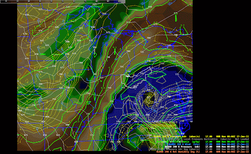 |
| WPC Surface Analysis from 2 PM EST Jan 16 to 5 PM EST Jan 17, 2022. | Advected layer precipitable water (ALPW) product, showing water content in different levels of the atmosphere. Sfc - 850 mb (top left), 850 to 700 mb (top right), 700 to 500 mb (bottom left), 500 to 300 mb (bottom right). Note the moisture source extended down towards the Caribbean and perhaps as far south as Central America. | 290K Isentropic loop from 7 PM EST Jan 16 to 1 PM Jan 17, 2022, showing the deformation zone over our area, along with a trough of warm air aloft (TROWAL) and deeper moisture wrapping in from the east. |
 |
.gif) |
.net-gifmaker.gif) |
| SPC Mesoanalysis 500 mb height and vorticity from 7 AM Jan 16 to 2 PM Jan 17, 2022 | SPC Mesoanlysis precipitable water (PWAT) and 850 mb transport vectors from 1 AM Jan 16 through 1 PM Jan 17, 2022 | SPC mesoanalysis 700 mb frontogenesis (red contours) and 500-650 mb EPVg (color fill) from 7 PM Jan 16 - 7 AM Jan 17. Frontogenesis is a source of vertical motion, and negative EPVg indicates an atmosphere unstable to slantwise motion. This can lead to slantwise convection, a common cause of heavy banded snow. |
This storm was unique in that it brought heavy snow all the way into the Cleveland area despite the surface low starting east of the Appalachians. It is fairly uncommon for storms to track right up the spine of the Appalachians (they usually go to the east or west). This storm likely cut so far inland because the 500 mb low was already closed off over the Gulf Coast. Heights in the closed 500 mb low on Sunday over the Gulf Coast states were greater than 3 standard deviations below normal! This was an anomalously strong system aloft early on, and that likely allowed for the surface low to quickly intensify and then occlude / stack with the mid and upper-level portions of the storm farther west, taking it over the Appalachians and putting a larger portion of Ohio in the region of heavy snow to the northwest of the low pressure. Another unique element was a tap of Atlantic moisture into our region. As can be seen in the PWAT and 850 mb moisture transport vector loop and ALPW image, our system had a tropical feed of moisture and was strong enough to our south to draw a significant amount of that into our region from the south and east. This essentially gave us the amount of moisture that East Coast nor'easters have to work with, which isn't common in our winter storms.
The thermodynamic profile of the atmosphere along with smaller-scale (mesoscale) snow bands helped contribute to the especially prolific snow rates and impressive totals that occurred along and east of the I-77 corridor. As can be seen both in the water vapor loop and 290k isentropic loop, eastern OH and western PA were located where the storm's TROWAL, deformation zone, frontogenesis and deeper moisture all aligned. The TROWAL brought in warmer, more moisture-rich air aloft. The edge of the dry slot to our east brought drier air in aloft overtop of the richer moisture; a drier layer of air overtop of a moist layer of air weakens the amount of stability in the atmosphere when those layers of air are lifted, which can strengthen vertical motion. The deformation zone caused general large-scale lift across the area (common in most winter storms). As the storm began pulling in colder air from the west and the TROWAL (warmer air aloft) nosed in from the east, it tightened the mid-level temperature gradient across eastern Ohio and western PA Sunday night. This led to frontogenesis. Frontogenesis causes vertical motion, with this vertical motion enhanced by the weakened stability described above. The 700 mb frontogenesis and 500-650 mb EPVg loop is an easy way to visualize the frontogenesis ramping up as stability weakened aloft, and aligns with when heavy snow bands developed across the region.
Soundings From The Event (PBZ - top & BUF - bottom)
 |
 |
 |
| 00z sounding from PBZ on Jan 17, 2022. Note the temperature profile nearing the 0-degree line. Sleet mixed in with snow for much of the first half of the event in our area. | 06Z sounding from PBZ on Jan 17, 2022. | 08Z sounding from PBZ on Jan 17, 2022. Note that the temperature profile aloft has cooled significantly versus the previous two soundings. Precipitation type was all snow at this point in the event. |
 |
 |
 |
 |
| 00Z sounding from BUF on Jan 17, 2022. | 06Z sounding from BUF on Jan 17, 2022. Note the temperature profile nearing the 0-degree line. Warm air advection in the low to mid-levels was reaching as far north as western NY. | 09Z sounding from BUF on Jan 17, 2022. Note that the temperature profile aloft has cooled to where precipitation type is now all snow. | 12Z sounding from BUF on Jan 17, 2022. |
Soundings in both Buffalo and Pittsburgh briefly warmed to near freezing (the 0C line) around 850 mb Sunday evening into Sunday night due to strong warm air advection from the east and southeast. Sleet and freezing rain were observed for a time in eastern Ohio and western PA Sunday evening as this occurred, but ultimately didn't do much to limit snow totals given how much moisture there was to work with the rest of the night. Another thing that's notable is the amount of moisture in the atmosphere. Note how soundings at both locations saturate through a very deep layer of the atmosphere (green and red lines on top of each other, indicating little temperature and dew point spread), along with precipitable water values at both reaching 0.60" during the storm; this is high for the snowy side of a winter storm.
What's also noticeable is the temperature and wind profile aloft. At both locations (especially around 6z in Pittsburgh and 6z and 9z in Buffalo) temperatures aloft cool fairly quickly (note the slope of the temperature to the left as you move up the middle portions of the soundings). While not as unstable as what we'd see in a summer-time thunderstorm situation, this indicates a less stable atmosphere than we typically see in winter and can contribute to heavy banded snow. The wind profiles veering and increasing in speed with height also indicated the region was in a favorable region for heavy banded snowfall near the entrance quadrant of an upper-level jet streak.
SPC Mesoscale Discussions During The Event.
 |
 |
 |
 |
| SPC MD #1 | SPC MD #2 | SPC MD #3 | SPC MD #4 |
 |
Media use of NWS Web News Stories is encouraged! Please acknowledge the NWS as the source of any news information accessed from this site. |
|


