Overview
|
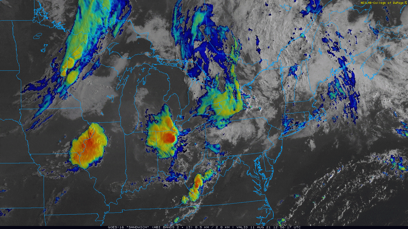
A warm and moist air mass set up across the region, characterized by dew points in the lower to mid-70s and instability parameters in the moderate to strong range. Multiple rounds of strong to severe thunderstorms moved across the area Wednesday morning into Friday, with portions of the region outlooked in a SPC Enhanced Risk for two out of the three days, mainly for a damaging wind threat, though a few instances of large hail did occur, given the large instability in the hail growth zone (-10C to -30C layer). Deep layer shear was relatively weak through all three days, though modest mid-level flow around 35 to 40 knots helped to sustain generally multi-cell and cold pool-driven convection, along with nocturnal mesoscale convective systems, which helped to provide surface lifting mechanisms and enhanced low to mid-level shear profiles. Wednesday, August 11 was characterized by having two main rounds of severe convection; one in the morning and one in the afternoon. The Storm Prediction Center (SPC) increased a portion of our area under an enhanced risk at the 1230 PM update. The convection in the afternoon proved to be the most widespread and strongest, with NWS CLE issuing our first 80 mph WEA-generated severe thunderstorm warning since implementation this year which was credited to saving at least one person’s life. The lakeshore areas were hit particularly hard with widespread tree damage noted. Thursday, August 12 had two main rounds of severe convection; one in the morning and one in the afternoon. The SPC increased a portion of our area under an enhanced risk at the 1230 PM update. The strongest storms formed generally along and east of the I-77 corridor as they moved east into PA by the evening hours. Most storms exhibited mainly a damaging wind threat, though one storm produced large to very large hail across a small portion of Northwest Pennsylvania from a left-splitting cell. Golf ball-sized hail was reported in the Titusville, PA area. Finally, Friday, August 13 had one main round of strong to severe convection in the late afternoon and evening. The main threat from this convection was damaging winds, though heavy rain also occurred, with one flood advisory issued. This was the end of a very busy weather week, with a cold front finally moving east across the region by nighttime. |
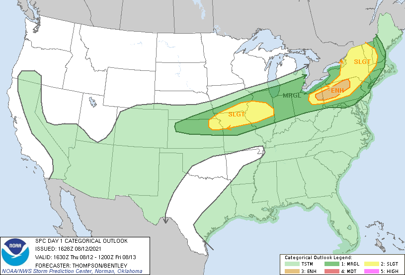
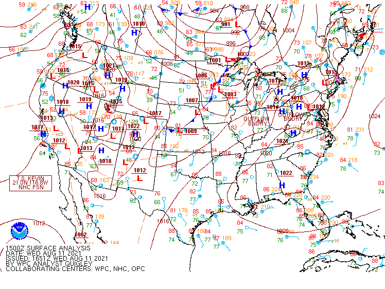
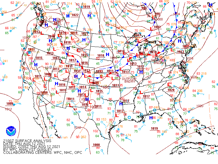
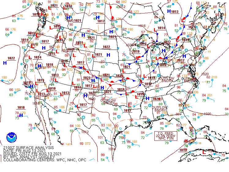
SPC 1630Z (1230 PM ET) day 1 severe thunderstorm outlooks from August 11 (left) and August 12, 2021 (right). |
Photos & Video
 |
 |
 |
 |
| Golf-ball size hail in Titusville, PA on Aug 12, 2021. (Crawford County, PA EM) |
Golf-ball size hail in Hydeville, PA on Aug 12, 2021. (Crawford County, PA EM) |
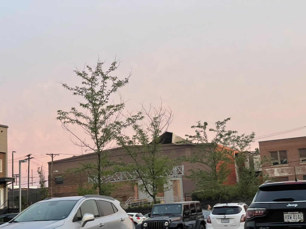
Roof damage in Gordan Square at W 58 St from the afternoon storms that rolled across northern OH on Aug 11, 2021. (Kelly Dobeck) |
Picture of a shelf cloud on Aug 11, 2021 in Avon Lake, OH before severe storms rolled across the lakeshore areas of northern OH. (Zakk Sheehan) |
 |
 |
 |
 |
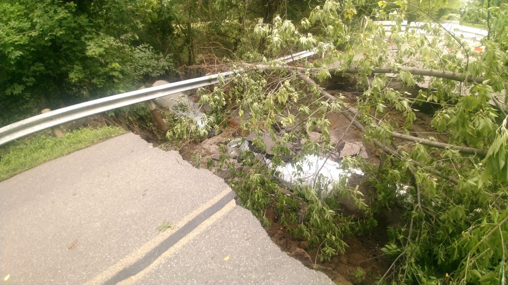
| Storm damage in Liberty Township, Trumbull County, OH from the storms that rolled across the area on the evening of Aug 13, 2021. (Jim T) |
Tree uprooted onto house from the severe storms that rolled through Bay Village, OH on Aug 11, 2021. (Kristin Mazur) |
Picture of a sheld cloud on Aug 11, 2021 in Lorain, OH before severe storms rolled across the region. (Russ Marty) |
Gas station canopy down from thunderstorm winds in Hudson, OH on Aug 13, 2021. (Mark Watt) |
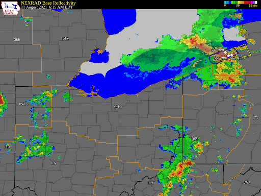
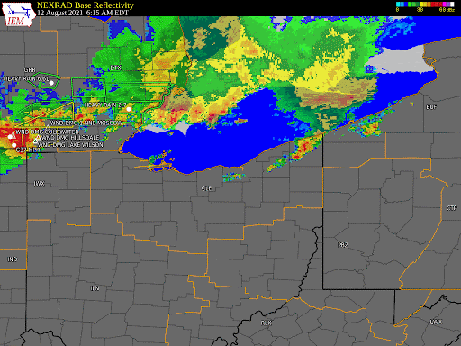
Radar
Three days of radar, showing the multiple rounds of storms across the region
 |
 |
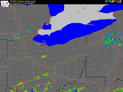 |
| Radar loop with severe and flood warnings on Aug 11, 2021 from 6 AM to 9 PM. | Radar loop with severe and flood warnings on Aug 12, 2021 from 6 AM to 9 PM. | Radar loop for severe and flood warnings on Aug 13, 2021 from 3 PM to 10 PM. |
Storm Reports
000
NWUS51 KCLE 141416
LSRCLE
PRELIMINARY LOCAL STORM REPORT...SUMMARY
NATIONAL WEATHER SERVICE CLEVELAND OH
1016 AM EDT SAT AUG 14 2021
..TIME... ...EVENT... ...CITY LOCATION... ...LAT.LON...
..DATE... ....MAG.... ..COUNTY LOCATION..ST.. ...SOURCE....
..REMARKS..
0237 AM LIGHTNING 2 ENE PEMBERVILLE 41.43N 83.42W
08/11/2021 SANDUSKY OH TRAINED SPOTTER
LIGHTNING HIT A HOME AND POWER POLE NEAR THE
INTERSECTION OF US 23 AND SR 105 IN SANDUSKY
COUNTY.
0241 AM TSTM WND DMG LUCKEY 41.45N 83.49W
08/11/2021 WOOD OH TRAINED SPOTTER
12 INCH DIAMETER TREE DOWN ON MAIN STREET IN
LUCKEY.
0243 AM TSTM WND GST 1 SSE WALBRIDGE 41.57N 83.48W
08/11/2021 M56 MPH WOOD OH ASOS
ASOS STATION KTDZ TOLEDO EXECUTIVE AIRPORT.
0245 AM TSTM WND DMG GENOA 41.52N 83.36W
08/11/2021 OTTAWA OH EMERGENCY MNGR
MULTIPLE DOWNED TREES AND DAMAGE TO A BARN
ROOF IN GENOA.
0248 AM MARINE TSTM WIND 1 W HARBOR VIEW 41.69N 83.47W
08/11/2021 M49 MPH LUCAS OH C-MAN STATION
C-MAN STATION THRO1 TOLEDO, OH.
0257 AM TSTM WND DMG 1 NNE BALLVILLE 41.34N 83.13W
08/11/2021 SANDUSKY OH TRAINED SPOTTER
TREE DOWN AT THE HAYES CENTER COMPLEX IN
FREMONT AND SEVERAL WIRES DOWN ON JUNE ST IN
BALLVILLE TOWNSHIP.
0305 AM TSTM WND GST 7 N OAK HARBOR 41.61N 83.12W
08/11/2021 M44 MPH OTTAWA OH PUBLIC
*DELAYED REPORT* PERSONAL WEATHER STATION.
0834 AM TSTM WND DMG 1 SSW FINDLAY 41.03N 83.64W
08/11/2021 HANCOCK OH TRAINED SPOTTER
SEVERAL LARGE LIMBS DOWN AND ONE UTILITY
POLE BROKEN OFF. TIME ESTIMATED FROM RADAR.
0900 AM TSTM WND DMG FINDLAY 41.04N 83.64W
08/11/2021 HANCOCK OH 911 CALL CENTER
NUMEROUS TREES DOWN.
0950 AM TSTM WND DMG 3 NE WILLARD 41.09N 82.69W
08/11/2021 HURON OH TRAINED SPOTTER
MULTIPLE TRESS DOWN ALONG PERU OLENA RD.
0950 AM TSTM WND DMG WILLARD 41.05N 82.72W
08/11/2021 HURON OH TRAINED SPOTTER
NUMEROUS TREES DOWN.
1028 AM TSTM WND DMG 1 SSW MANSFIELD 40.75N 82.54W
08/11/2021 RICHLAND OH PUBLIC
ONE LARGE LIMB DOWN.
1051 AM TSTM WND GST 2 SSW GREEN 40.92N 81.45W
08/11/2021 M54 MPH SUMMIT OH ASOS
ASOS STATION KCAK AKRON-CANTON REGIONAL
ARPT.
1114 AM MARINE TSTM WIND 6 WNW MARBLEHEAD 41.55N 82.83W
08/11/2021 M45 MPH OTTAWA OH PUBLIC
*DELAYED REPORT* PERSONAL WEATHER STATION.
0326 PM TSTM WND DMG 2 NW HOLLAND 41.64N 83.74W
08/11/2021 LUCAS OH TRAINED SPOTTER
LIVE 18 INCH DIAMETER LIMB DOWN.
0326 PM TSTM WND GST 2 WNW ROSSFORD 41.61N 83.60W
08/11/2021 M72 MPH LUCAS OH TRAINED SPOTTER
0328 PM TSTM WND DMG 3 NNW NORTHWOOD 41.64N 83.51W
08/11/2021 LUCAS OH PUBLIC
LARGE TREE DOWN NEAR INTERSECTION OF SPRING
GROVE AND GREENWOOD ROADS.
0349 PM TSTM WND DMG 3 NNE OTTAWA HILLS 41.71N 83.62W
08/11/2021 LUCAS OH PUBLIC
3-INCH TREE LIMBS BROKEN; POWER POLES
BROKEN.
0352 PM HAIL MOUNT BLANCHARD 40.90N 83.56W
08/11/2021 E0.75 INCH HANCOCK OH TRAINED SPOTTER
ESTIMATED 30-40 MPH WINDS.
0356 PM TSTM WND DMG OAK HARBOR 41.51N 83.15W
08/11/2021 OTTAWA OH PUBLIC
DAMAGE TO A ROOF ON A HOME. NUMEROUS
SHINGLES LIFTED AND TORN OFF.
0358 PM TSTM WND DMG 10 NW MARBLEHEAD 41.65N 82.82W
08/11/2021 OTTAWA OH LAW ENFORCEMENT
NUMEROUS TREES AND POWERLINES DOWN ACROSS
SOUTH BASS ISLAND.
0400 PM TSTM WND GST 2 ENE PORT CLINTON 41.52N 82.89W
08/11/2021 M51 MPH OTTAWA OH PUBLIC
*DELAYED REPORT* PERSONAL WEATHER STATION.
0402 PM TSTM WND DMG 4 NNE OTTAWA HILLS 41.72N 83.62W
08/11/2021 LUCAS OH TRAINED SPOTTER
LARGE TREE DOWN.
0410 PM TSTM WND DMG 2 NE ROSSFORD 41.62N 83.53W
08/11/2021 LUCAS OH TRAINED SPOTTER
DAMAGE TO BUILDING ROOF.
0416 PM MARINE TSTM WIND 6 N BAY VIEW 41.55N 82.83W
08/11/2021 M42 MPH OTTAWA OH PUBLIC
*DELAYED REPORT* PERSONAL WEATHER STATION.
0422 PM TSTM WND GST 6 N MARBLEHEAD 41.61N 82.72W
08/11/2021 M67 MPH ERIE OH PUBLIC
*DELAYED REPORT* PERSONAL WEATHER STATION.
0422 PM TSTM WND DMG GIBSONBURG 41.39N 83.33W
08/11/2021 SANDUSKY OH TRAINED SPOTTER
9 INCH DIAMETER, 30 FOOT TREE DOWN ACROSS
ROAD AND POWER LINES.
0427 PM TSTM WND DMG BUCYRUS 40.81N 82.98W
08/11/2021 CRAWFORD OH TRAINED SPOTTER
LARGE TREE DOWN.
0429 PM TSTM WND DMG BUCYRUS 40.81N 82.98W
08/11/2021 CRAWFORD OH PUBLIC
LARGE TREE DOWN ON SPRING STREET.
0432 PM TSTM WND DMG 1 ENE MARION 40.59N 83.11W
08/11/2021 MARION OH PUBLIC
MULTIPLE TREES DOWN ON THE EAST SIDE OF
MARION.
0433 PM TSTM WND GST 3 NNE LINNDALE 41.48N 81.74W
08/11/2021 E80 MPH CUYAHOGA OH PUBLIC
TREE FELL ON A TRUCK.
0433 PM TSTM WND GST WILLARD 41.05N 82.72W
08/11/2021 E50 MPH HURON OH TRAINED SPOTTER
0435 PM TSTM WND DMG PLYMOUTH 40.99N 82.67W
08/11/2021 RICHLAND OH EMERGENCY MNGR
ONE HOME WAS SEVERELY DAMAGE WITH AN
EXTERIOR WALL COLLAPSED. A DETACHED GARAGE
WAS HEAVILY DAMAGE. NUMEROUS TREES WERE
BLOWN DOWN ACROSS THE COUNTY.
0451 PM TSTM WND DMG 2 W HURON 41.40N 82.60W
08/11/2021 ERIE OH PUBLIC
1-INCH TREE LIMBS BROKEN; SHINGLES BLOWN
OFF.
0452 PM TSTM WND GST 3 NNE LORAIN 41.48N 82.16W
08/11/2021 M45 MPH LORAIN OH PUBLIC
*DELAYED REPORT* PERSONAL STATION.
0452 PM TSTM WND GST 4 N MANSFIELD 40.82N 82.52W
08/11/2021 M53 MPH RICHLAND OH ASOS
ASOS STATION KMFD MANSFIELD.
0453 PM TSTM WND DMG 1 ESE MOUNT GILEAD 40.55N 82.82W
08/11/2021 MORROW OH PUBLIC
TREES SNAPPED AND DAMAGE TO METAL ROOF.
0457 PM TSTM WND DMG AVON LAKE 41.49N 82.02W
08/11/2021 LORAIN OH PUBLIC
LARGE TREE UPROOTED WHICH TOOK DOWN
POWERLINES AND A FENCE.
0457 PM TSTM WND DMG AVON LAKE 41.49N 82.02W
08/11/2021 LORAIN OH PUBLIC
NUMEROUS TREES SNAPPED IN HALF VIA VIDEO
SUBMITTED ON SOCIAL MEDIA.
0504 PM TSTM WND DMG 4 W LEXINGTON 40.68N 82.66W
08/11/2021 MORROW OH TRAINED SPOTTER
SEVERAL TREES DOWN.
0504 PM TSTM WND DMG MANSFIELD 40.76N 82.52W
08/11/2021 RICHLAND OH TRAINED SPOTTER
SEVERAL LARGE TREES DOWN AROUND CITY.
0506 PM TSTM WND DMG ELYRIA 41.38N 82.11W
08/11/2021 LORAIN OH PUBLIC
MULTIPLE TREES SNAPPED AND BLOCKING ROADWAYS
ACROSS ELYRIA.
0506 PM TSTM WND DMG 1 NW WESTLAKE 41.47N 81.95W
08/11/2021 CUYAHOGA OH PUBLIC
LARGE TREE DOWN ACROSS CLEMENS ROAD.
0506 PM TSTM WND DMG 2 WNW ROCKY RIVER 41.48N 81.89W
08/11/2021 CUYAHOGA OH BROADCAST MEDIA
LARGE TREE FELL ONTO HOME CAUSING ROOF
DAMAGE.
0506 PM TSTM WND DMG BAY VILLAGE 41.49N 81.92W
08/11/2021 CUYAHOGA OH 911 CALL CENTER
EXTENSIVE TREE AND POWERLINE DAMAGE ACROSS
THE CITY.
0509 PM TSTM WND DMG FREDERICKTOWN 40.48N 82.55W
08/11/2021 KNOX OH 911 CALL CENTER
NUMEROUS TREES AND POWERLINES DOWN
THROUGHOUT FREDERICKTOWN.
0509 PM TSTM WND DMG 3 SW WESTLAKE 41.43N 81.97W
08/11/2021 CUYAHOGA OH PUBLIC
LARGE TREE UPROOTED AND FELL ONTO HOUSE ON
HILLIARD BLVD.
0511 PM TSTM WND GST 2 WNW BAY VILLAGE 41.50N 81.96W
08/11/2021 E75 MPH CUYAHOGA OH NWS EMPLOYEE
ESTIMATED 70-75 MPH WIND GUST.
0511 PM TSTM WND DMG 2 WNW BAY VILLAGE 41.50N 81.96W
08/11/2021 CUYAHOGA OH NWS EMPLOYEE
MULTIPLE TREES AND POWER POLES/LINES DOWN.
0512 PM TSTM WND GST BUTLER 40.59N 82.42W
08/11/2021 E70 MPH RICHLAND OH TRAINED SPOTTER
0518 PM TSTM WND DMG 3 W CLEVELAND 41.48N 81.73W
08/11/2021 CUYAHOGA OH BROADCAST MEDIA
MULTIPLE TREES SNAPPED AND A ROOF TORN OFF A
WAREHOUSE IN GORDON SQUARE.
0518 PM TSTM WND DMG LAKEWOOD 41.48N 81.80W
08/11/2021 CUYAHOGA OH PUBLIC
NUMEROUS LARGE TREES AND POWER LINES
REPORTED DOWN ACROSS THE CITY.
0518 PM TSTM WND DMG LAKEWOOD 41.48N 81.80W
08/11/2021 CUYAHOGA OH NWS EMPLOYEE
SNAPPED TREE FELL ONTO GARAGE.
0518 PM TSTM WND DMG 1 SW LINNDALE 41.43N 81.78W
08/11/2021 CUYAHOGA OH PUBLIC
POWER POLES SNAPPED IN HALF AND LINES DOWN
ON WEST 130.
0520 PM TSTM WND DMG MOUNT VERNON 40.39N 82.48W
08/11/2021 KNOX OH 911 CALL CENTER
NUMEROUS TREES AND POWERLINES DOWN ACROSS
THE CITY OF MOUNT VERNON.
0520 PM TSTM WND DMG 1 NNE EUCLID 41.61N 81.51W
08/11/2021 CUYAHOGA OH LAW ENFORCEMENT
LARGE TREE FELL ONTO HOUSE RESULTING IN A
HOLE IN THE ROOF.
0520 PM TSTM WND DMG 1 ESE EUCLID 41.59N 81.50W
08/11/2021 CUYAHOGA OH LAW ENFORCEMENT
LARGE TREE FELL CAUSING MAJOR DAMAGE TO 3
VEHICLES.
0523 PM TSTM WND DMG 1 WSW BRATENAHL 41.55N 81.61W
08/11/2021 CUYAHOGA OH LAW ENFORCEMENT
LARGE TREE FELL ONTO VEHICLE ON HANNA LANE.
0523 PM TSTM WND DMG PARMA 41.38N 81.73W
08/11/2021 CUYAHOGA OH PUBLIC
LARGE TREE UPROOTED WHICH CLIPPED A CORNER
OF A HOUSE.
0525 PM TSTM WND DMG DANVILLE 40.45N 82.26W
08/11/2021 KNOX OH 911 CALL CENTER
NUMEROUS TREES AND POWERLINES DOWN
THROUGHOUT DANVILLE.
0525 PM TSTM WND DMG 1 WNW LYNDHURST 41.52N 81.51W
08/11/2021 CUYAHOGA OH PUBLIC
LARGE TREE SNAPPED.
0525 PM TSTM WND DMG MENTOR 41.69N 81.34W
08/11/2021 LAKE OH TRAINED SPOTTER
MULTIPLE LARGE TREE LIMBS DOWN, ONE ON A
VEHICLE.
0527 PM TSTM WND GST 3 N CLEVELAND 41.52N 81.68W
08/11/2021 M55 MPH CUYAHOGA OH ASOS
ASOS STATION KBKL CLEVELAND.
0530 PM TSTM WND DMG MENTOR 41.69N 81.33W
08/11/2021 LAKE OH PUBLIC
LARGE TREE SNAPPED.
0532 PM TSTM WND DMG GLENMONT 40.52N 82.09W
08/11/2021 HOLMES OH EMERGENCY MNGR
TREES AND WIRES DOWN ON SR520.
0532 PM TSTM WND DMG 1 SW KIRTLAND HILLS 41.63N 81.33W
08/11/2021 LAKE OH PUBLIC
LARGE TREE DOWN ACROSS SANCTUARY ROAD.
0533 PM TSTM WND DMG 1 WSW SHAKER HEIGHTS 41.47N 81.57W
08/11/2021 CUYAHOGA OH AMATEUR RADIO
MANY TREE LIMBS AND SEVERAL WHOLE TREES DOWN
IN SHAKER HEIGHTS. TIME ESTIMATED VIA RADAR.
0537 PM TSTM WND DMG 3 W KILLBUCK 40.50N 82.03W
08/11/2021 HOLMES OH EMERGENCY MNGR
MULTIPLE TREES AND WIRES DOWN ON CR 6
BETWEEN KILLBUCK AND GLENMONT.
0540 PM TSTM WND GST 1 N WADSWORTH 41.04N 81.73W
08/11/2021 E65 MPH MEDINA OH TRAINED SPOTTER
ESTIMATED 60-65 MPH WIND GUST, TREE LIMBS
DOWN AND SHINGLES OFF BUILDINGS.
0546 PM TSTM WND DMG 1 W SOLON 41.39N 81.46W
08/11/2021 CUYAHOGA OH LAW ENFORCEMENT
LARGE TREE LIMB FELL ONTO CAR ON SOLON ROAD.
0547 PM TSTM WND GST 4 W ASHTABULA 41.88N 80.87W
08/11/2021 M41 MPH ASHTABULA OH PUBLIC
*DELAYED REPORT* PERSONAL WEATHER STATION.
0555 PM TSTM WND DMG 4 ENE CHARDON 41.61N 81.14W
08/11/2021 GEAUGA OH AMATEUR RADIO
TREE DOWN INTO WIRES.
0557 PM TSTM WND DMG TALLMADGE 41.10N 81.42W
08/11/2021 SUMMIT OH FIRE DEPT/RESCUE
NUMEROUS TREES AND POWERLINES DOWN ACROSS
THE CITY.
0557 PM TSTM WND DMG 2 N GREEN 40.96N 81.44W
08/11/2021 SUMMIT OH PUBLIC
TREE DOWN AND MULTIPLE LARGE BRANCHES
SNAPPED AT PRESTWICK COUNTRY CLUB.
0604 PM TSTM WND DMG 5 NNE WEST FARMINGTON 41.46N 80.95W
08/11/2021 TRUMBULL OH 911 CALL CENTER
NUMEROUS TREES AND POWERLINES DOWN THROUGH
MESOPOTAMIA TOWNSHIP.
0606 PM TSTM WND DMG HIRAM 41.31N 81.14W
08/11/2021 PORTAGE OH 911 CALL CENTER
NUMEROUS TREES AND POWERLINES REPORTED DOWN
ACROSS HIRAM AND HIRAM TOWNSHIP.
0608 PM TSTM WND GST 2 NNE CONNEAUT 41.96N 80.55W
08/11/2021 M54 MPH ASHTABULA OH PUBLIC
*DELAYED REPORT* PERSONAL WEATHER STATION.
0609 PM TSTM WND DMG 3 ENE GARRETTSVILLE 41.31N 81.04W
08/11/2021 PORTAGE OH 911 CALL CENTER
NUMEROUS TREES AND POWERLINE REPORTED DOWN
ACROSS NELSON TOWNSHIP.
0611 PM TSTM WND DMG GARRETTSVILLE 41.28N 81.10W
08/11/2021 PORTAGE OH 911 CALL CENTER
NUMEROUS TREES AND POWERLINES DOWN
THROUGHOUT GARRETTSVILLE.
0623 PM TSTM WND DMG 8 NNW ORANGEVILLE 41.45N 80.58W
08/11/2021 TRUMBULL OH 911 CALL CENTER
NUMEROUS TREES AND POWERLINES DOWN ACROSS
KINSMAN TOWNSHIP.
0623 PM TSTM WND DMG 1 SSE ASHTABULA 41.87N 80.79W
08/11/2021 ASHTABULA OH PUBLIC
3-INCH TREE LIMBS BROKEN; POWER POLES
BROKEN.
0632 PM TSTM WND DMG CONNEAUT LAKE 41.60N 80.31W
08/11/2021 CRAWFORD PA 911 CALL CENTER
NUMEROUS TREES REPORTED DOWN ACROSS CONNEAUT
LAKE.
0635 PM TSTM WND DMG 4 WSW MEADVILLE 41.63N 80.22W
08/11/2021 CRAWFORD PA 911 CALL CENTER
NUMEROUS TREES REPORTED DOWN ACROSS VERNON
TOWNSHIP.
0639 PM TSTM WND DMG 2 S EDINBORO 41.84N 80.12W
08/11/2021 CRAWFORD PA TRAINED SPOTTER
SEVERAL 8 INCH DIAMETER TREES SNAPPED OFF
AND ESTIMATED 50-60 MPH WIND GUST.
0640 PM TSTM WND DMG 1 NE CONNEAUT LAKESHORE 41.63N 80.30W
08/11/2021 CRAWFORD PA PUBLIC
DELAYED REPORT AND TIME ESTIMATED VIA RADAR.
PROBABLE DOWNBURST DAMAGED A BOAT AND TWO
DOCKS, BLEW OUT A HOUSE WINDOW, AND DOWNED
BRANCHES ONTO A PORCH, DAMAGING IT.
0644 PM TSTM WND DMG BROOKFIELD CENTER 41.24N 80.56W
08/11/2021 TRUMBULL OH 911 CALL CENTER
NUMEROUS TREES AND POWERLINES REPORTED DOWN
ACROSS BROOKFIELD CENTER.
0650 PM TSTM WND DMG COCHRANTON 41.52N 80.05W
08/11/2021 CRAWFORD PA 911 CALL CENTER
NUMEROUS TREES REPORTED DOWN THROUGHOUT THE
CITY OF COCHRANTON.
0739 AM NON-TSTM WND GST 4 W ASHTABULA 41.88N 80.87W
08/12/2021 M46 MPH ASHTABULA OH PUBLIC
*DELAYED REPORT* PERSONAL WEATHER STATION.
0918 AM TSTM WND GST 1 NNW FAIRPORT HARBOR 41.76N 81.28W
08/12/2021 M50 MPH LAKE OH BUOY
BUOY STATION FAIO1 FAIRPORT, OH.
0918 AM TSTM WND GST 1 NNW FAIRPORT HARBOR 41.76N 81.28W
08/12/2021 M50 MPH LAKE OH BUOY
BUOY STATION FAIO1 FAIRPORT, OH.
0925 AM HAIL ASHLAND 40.87N 82.32W
08/12/2021 U0.75 INCH ASHLAND OH TRAINED SPOTTER
0.75 INCH HAIL.
1032 AM TSTM WND DMG 2 SE BAINBRIDGE 41.36N 81.31W
08/12/2021 GEAUGA OH 911 CALL CENTER
LARGE BRANCH AND UTILITY WIRES DOWN.
1038 AM TSTM WND DMG 6 NW HIRAM 41.38N 81.22W
08/12/2021 GEAUGA OH 911 CALL CENTER
TREE DOWN ON WIRES.
1100 AM TSTM WND DMG 5 S ORWELL 41.46N 80.87W
08/12/2021 TRUMBULL OH FIRE DEPT/RESCUE
SEVERAL TREES DOWN.
0351 PM TSTM WND DMG 2 ESE PENINSULA 41.22N 81.51W
08/12/2021 SUMMIT OH 911 CALL CENTER
TREE DOWN. TIME ESTIMATED FROM RADAR.
0357 PM TSTM WND DMG 2 NE CUYAHOGA FALLS 41.19N 81.49W
08/12/2021 SUMMIT OH TRAINED SPOTTER
SEVERAL LARGE LIMBS DOWN AND 8 INCH DIAMETER
TREES SNAPPED OFF.
0411 PM TSTM WND DMG 3 SW SILVER LAKE 41.13N 81.50W
08/12/2021 SUMMIT OH 911 CALL CENTER
TREE DOWN ON GARAGE.
0414 PM TSTM WND DMG 2 SW MUNROE FALLS 41.12N 81.47W
08/12/2021 SUMMIT OH 911 CALL CENTER
LARGE LIMB DOWN.
0420 PM TSTM WND DMG 1 SSW HUBBARD 41.14N 80.58W
08/12/2021 TRUMBULL OH AMATEUR RADIO
TREE DOWN AT LEWIS AVE. AND LINCOLN AVE. IN
MAPLEWOOD PARK. TIME ESTIMATED VIA RADAR.
0444 PM TSTM WND DMG WINDHAM 41.24N 81.04W
08/12/2021 PORTAGE OH BROADCAST MEDIA
TREE FELL ONTO BACKYARD POOL.
0449 PM TSTM WND DMG 3 NNW TURNPIKE INTERCHA 41.26N 80.95W
08/12/2021 TRUMBULL OH 911 CALL CENTER
TREE DOWN ON WIRES.
0514 PM HAIL HYDETOWN 41.65N 79.73W
08/12/2021 E1.75 INCH CRAWFORD PA PUBLIC
DELAYED REPORT. APPROXIMATELY GOLF BALL-SIZE
HAIL PER PHOTO. TIME ESTIMATED VIA RADAR.
0518 PM HAIL 2 NNE TITUSVILLE 41.66N 79.66W
08/12/2021 E1.75 INCH CRAWFORD PA PUBLIC
DELAYED REPORT. APPROXIMATELY GOLF BALL-SIZE
HAIL PER PHOTO. TIME ESTIMATED VIA RADAR.
0528 PM TSTM WND DMG 2 N CONNEAUT LAKESHORE 41.66N 80.31W
08/12/2021 CRAWFORD PA PUBLIC
DELAYED REPORT TREE DOWN ONTO A HOUSE ON
BRITTANY DR.
0536 PM TSTM WND DMG 2 NE BOARDMAN 41.05N 80.65W
08/12/2021 MAHONING OH AMATEUR RADIO
PER SCANNER, TREE DOWN ON HOUSE ON EUCLID
BLVD. IN BOARDMAN. TIME ESTIMATED VIA RADAR.
0540 PM TSTM WND DMG CONNEAUT LAKE 41.61N 80.30W
08/12/2021 CRAWFORD PA EMERGENCY MNGR
TREE FELL ONTO A HOUSE SEVERELY DAMAGING THE
HOME NEAR SUMMIT TOWNSHIP IN WESTERN
CRAWFORD COUNTY. A MOBILE HOME WAS SEVERELY
DAMAGED. NUMEROUS TREES WERE BLOWN DOWN.
TIME WAS ESTIMATED BY RADAR.
0731 PM TSTM WND DMG 2 SW CONNEAUT LAKE 41.58N 80.33W
08/13/2021 CRAWFORD PA 911 CALL CENTER
TREE DOWN. TIME ESTIMATED FROM RADAR.
0736 PM TSTM WND DMG 1 ESE HUDSON 41.24N 81.44W
08/13/2021 SUMMIT OH PUBLIC
GAS STATION CANOPY BLOWN OVER. TIME
ESTIMATED VIA RADAR.
0757 PM TSTM WND DMG 7 N TOWNVILLE 41.78N 79.86W
08/13/2021 CRAWFORD PA 911 CALL CENTER
TREE DOWN. TIME ESTIMATED FROM RADAR.
0815 PM FLOOD 2 NE PAINESVILLE 41.75N 81.22W
08/13/2021 LAKE OH 911 CALL CENTER
NUMEROUS STREETS FLOODED BY STANDING WATER.
0821 PM TSTM WND DMG 1 N MARSHALLVILLE 40.92N 81.73W
08/13/2021 WAYNE OH 911 CALL CENTER
TREE DOWN AND TELEPHONE POLE DOWN.
0830 PM FLOOD 1 NNW MENTOR 41.70N 81.34W
08/13/2021 LAKE OH 911 CALL CENTER
NUMEROUS STREETS FLOODED BY STANDING WATER.
0900 PM TSTM WND DMG WARREN 41.24N 80.81W
08/13/2021 TRUMBULL OH 911 CALL CENTER
NUMEROUS TREES DOWN ACROSS SOUTHERN HALF OF
THE COUNTY.
0424 PM MARINE TSTM WIND 1 NNW MARBLEHEAD 41.54N 82.73W
08/11/2021 M56 MPH LEZ143 OH OTHER FEDERAL
49 KNOT PEAK WIND.
0332 AM MARINE TSTM WIND 1 S MARBLEHEAD 41.51N 82.72W
08/11/2021 M51 MPH LEZ144 OH PUBLIC
*DELAYED REPORT* PERSONAL WEATHER STATION.
0916 AM MARINE TSTM WIND 2 NNE SANDUSKY 41.49N 82.70W
08/11/2021 M42 MPH LEZ144 OH MESONET
MESONET STATION XSDB 2 NNE SANDUSKY. 37 KNOT
PEAK WIND.
0930 AM MARINE TSTM WIND 1 ENE HURON 41.40N 82.54W
08/11/2021 M51 MPH LEZ144 OH OFFICIAL NWS OBS
44 KNOT PEAK WIND.
0426 PM MARINE TSTM WIND 2 NNE SANDUSKY 41.49N 82.70W
08/11/2021 M49 MPH LEZ144 OH MESONET
MESONET STATION XSDB 2 NNE SANDUSKY. 43 KNOT
PEAK WIND.
0429 PM MARINE TSTM WIND 1 S MARBLEHEAD 41.51N 82.72W
08/11/2021 M42 MPH LEZ144 OH PUBLIC
*DELAYED REPORT* PERSONAL WEATHER STATION.
0601 PM MARINE TSTM WIND 2 NNE SANDUSKY 41.49N 82.70W
08/13/2021 M40 MPH LEZ144 OH MESONET
MESONET STATION XSDB 2 NNE SANDUSKY. 35 KNOT
PEAK WIND.
0640 PM MARINE TSTM WIND 6 N AVONIA 42.13N 80.26W
08/11/2021 E42 MPH LEZ149 PA BUOY
37 KNOT PEAK WIND.
1030 AM TSTM WND GST 3 N ERIE 42.17N 80.10W
08/12/2021 M37 MPH LEZ149 PA MESONET
MESONET STATION EREP1 3 NNW ERIE.
0300 AM MARINE TSTM WIND 9 ENE OREGON 41.70N 83.26W
08/11/2021 M56 MPH LEZ142 OH C-MAN STATION
C-MAN STATION TWCO1 8 ENE OREGON.
0350 PM MARINE TSTM WIND 9 ENE OREGON 41.70N 83.26W
08/11/2021 M66 MPH LEZ142 OH MESONET
MESONET STATION TWCO1 8 ENE OREGON. 57 KNOT
PEAK WIND.
0500 PM MARINE TSTM WIND 9 ENE OREGON 41.70N 83.26W
08/13/2021 M40 MPH LEZ142 OH MESONET
MESONET STATION TWCO1 8 ENE OREGON. 35 KNOT
PEAK WIND.
0524 PM TSTM WND GST 20 N PORT CLINTON 41.80N 82.97W
08/13/2021 M65 MPH LEZ163 OH SHIP
TAKEN VIA ANEMOMETER ON THE MAST OF THE
SHIP.
0933 AM MARINE TSTM WIND 3 WNW VERMILION 41.43N 82.36W
08/11/2021 M47 MPH LEZ145 OH MESONET
MESONET STATION XVRM VERMILION. 41 KNOT PEAK
WIND.
0618 PM MARINE TSTM WIND 3 WNW VERMILION 41.43N 82.36W
08/13/2021 M39 MPH LEZ145 OH MESONET
MESONET STATION XVRM VERMILION. 34 KNOT PEAK
WIND.
0630 PM MARINE TSTM WIND 3 NNW LORAIN 41.48N 82.19W
08/13/2021 M39 MPH LEZ145 OH MESONET
MESONET STATION LORO1 2 NNW LORAIN. 34 KNOT
PEAK WIND.
0510 PM MARINE TSTM WIND 3 WNW CLEVELAND 41.50N 81.73W
08/11/2021 M58 MPH LEZ146 OH MESONET
MESONET STATION XCLE CLEVELAND - EDGEWATER.
50 KNOT PEAK WIND.
0519 PM MARINE TSTM WIND 3 WNW CLEVELAND 41.50N 81.73W
08/11/2021 M64 MPH LEZ146 OH MESONET
CORRECTS PREVIOUS NON-TSTM WND GST REPORT
FROM 3 WNW CLEVELAND. MESONET STATION XCLE
CLEVELAND - EDGEWATER. 56 KNOT PEAK WIND.
0708 PM MARINE TSTM WIND 3 WNW CLEVELAND 41.50N 81.73W
08/13/2021 M40 MPH LEZ146 OH MESONET
MESONET STATION XCLE CLEVELAND - EDGEWATER.
35 KNOT PEAK WIND.
0430 AM MARINE TSTM WIND 2 W GENEVA-ON-THE-LAKE 41.86N 80.97W
08/11/2021 M43 MPH LEZ147 OH C-MAN STATION
C-MAN STATION GELO1 1 W GENEVA-ON-THE-LAKE.
0340 AM MARINE TSTM WIND 19 NNW VERMILION 41.68N 82.40W
08/11/2021 M45 MPH LEZ164 OH BUOY
BUOY 45005 16 NW LORAIN.
0450 PM MARINE TSTM WIND 19 NNW VERMILION 41.68N 82.40W
08/11/2021 M54 MPH LEZ164 OH BUOY
47 KNOT PEAK WIND.
0610 PM MARINE TSTM WIND 19 NNW VERMILION 41.68N 82.40W
08/13/2021 E42 MPH LEZ164 OH BUOY
37 KNOT PEAK WIND.
&&
$$
Environment
The upper air analysis revealed a general lack of flow aloft. Much of the convection was driven by existing surface outflow boundaries from nocturnal convection and/or enhanced pockets of low to mid-level flow.
 |
 |
 |
| Surface analysis on August 11, 2021 at 15Z (11 AM). | Surface analysis on August 12, 2021 at 21Z (5 PM). | Surface analysis on August 13, 2021 at 21Z (5 PM). |
August 11, 2021
 |
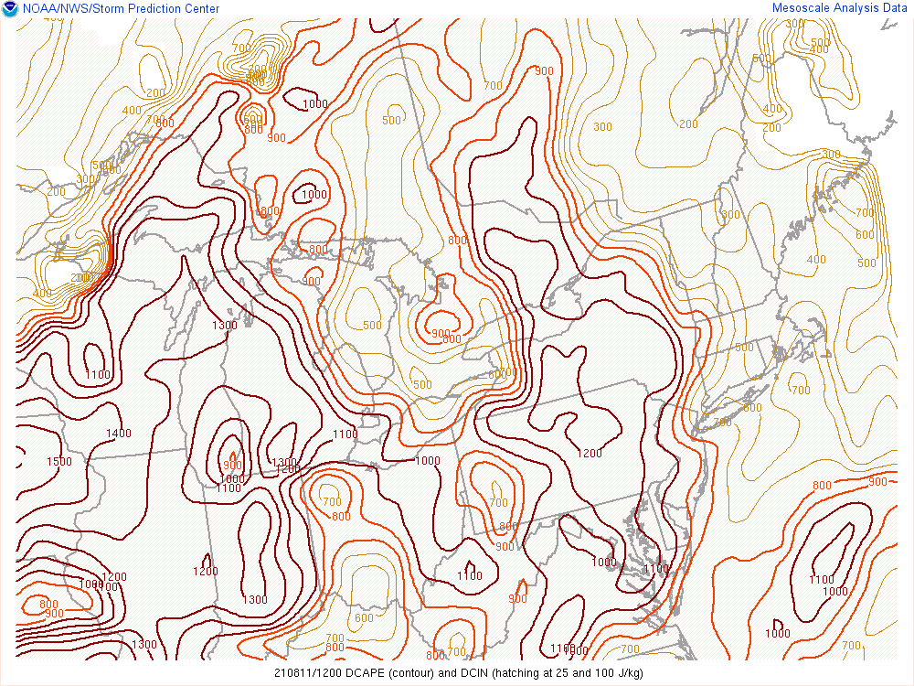 |
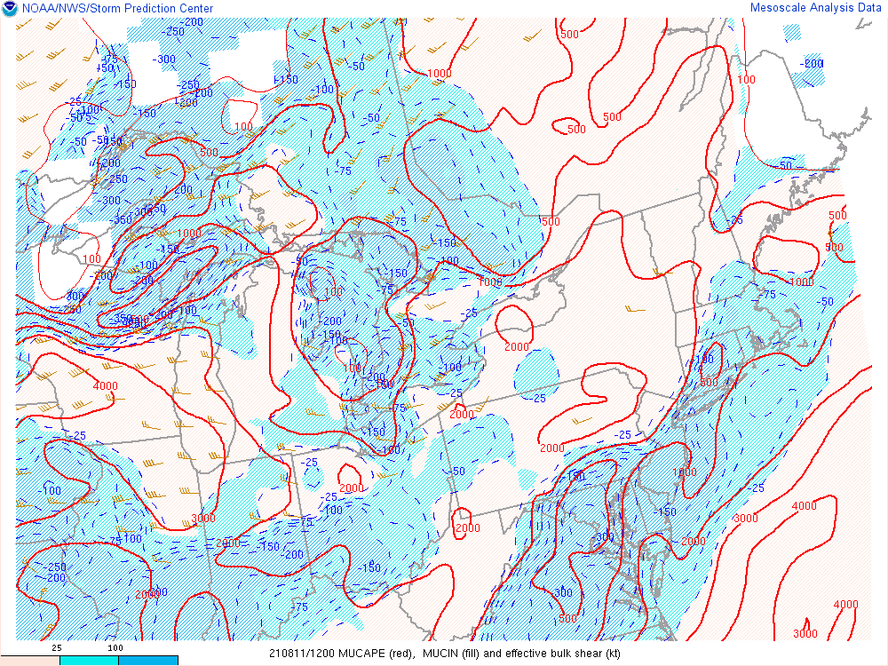
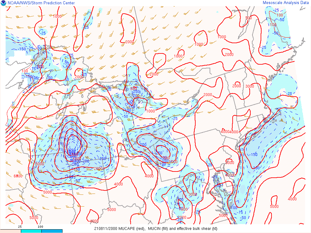
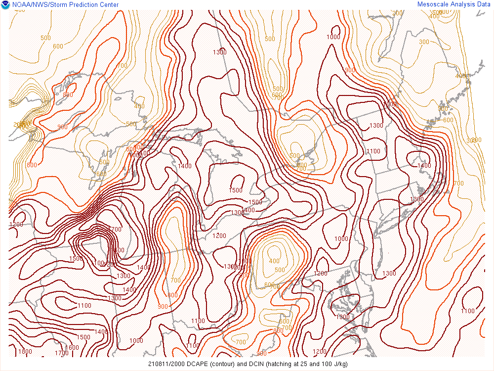
| MUCAPE and effective shear on August 11, 2021 at 12Z (8 AM). | DCAPE on August 11, 2021 at 12z (8 AM). Note the increasing values of DCAPE east of the complex on radar, indicating that the complex was moving into a more favorable environment for strong winds. |
 |
 |
| MUCAPE and effective shear on August 11, 2021 at 20Z (4 PM). | DCAPE on August 11, 2021 at 20z (4 PM). Note the increasing values of DCAPE east of the complex on radar, indicating that the complex was moving into a more favorable environment for strong winds. |
August 12, 2021
 |
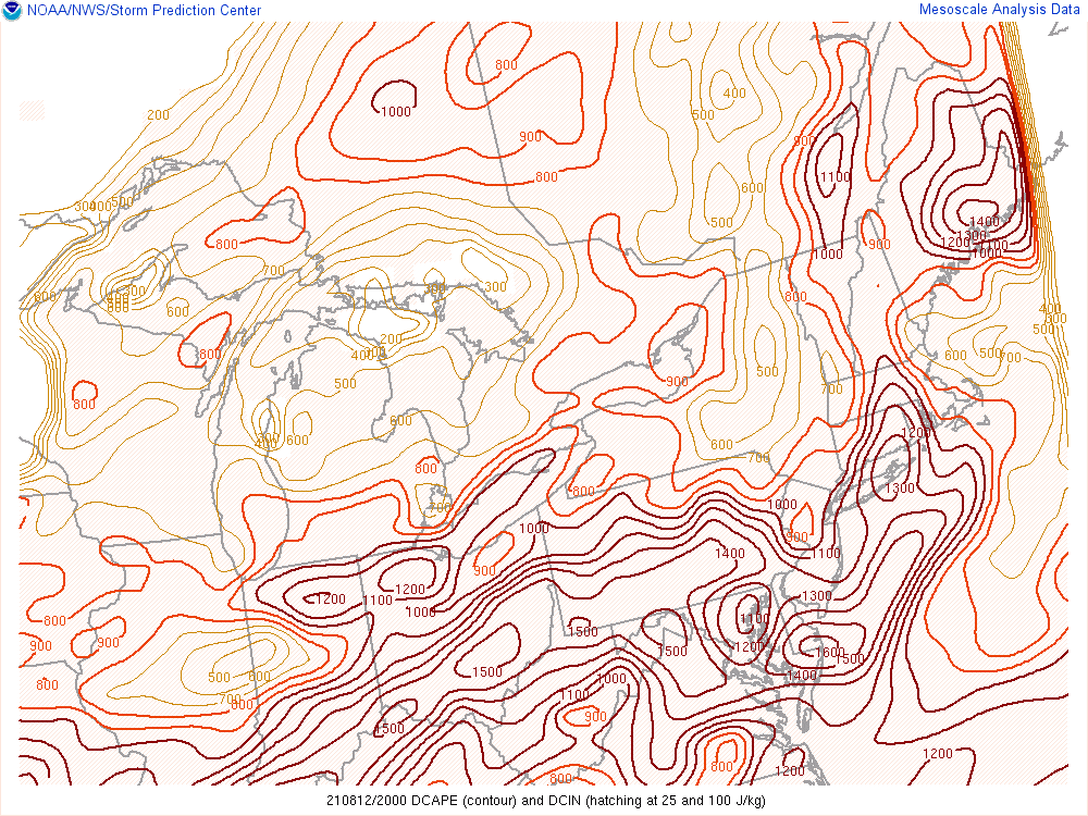 |
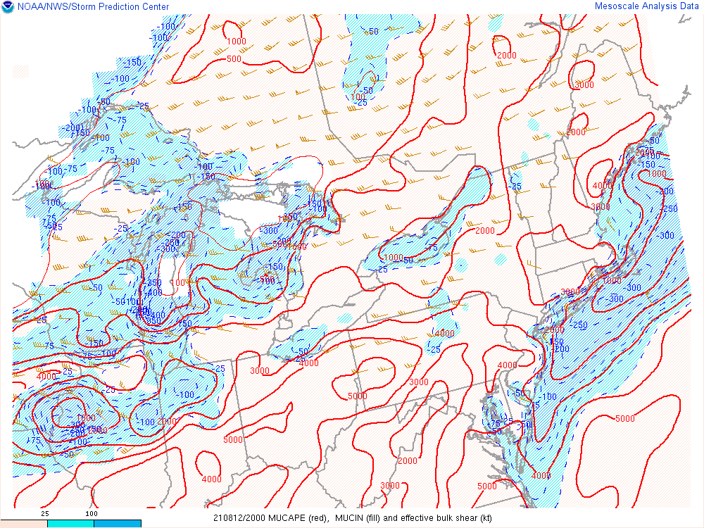
| MUCAPE and effective shear on August 12, 2021 at 20Z (4 PM). | DCAPE on August 12, 2021 at 20z (4 PM). Note the increasing values of DCAPE towards the southeast portion of the area. |
August 13, 2021
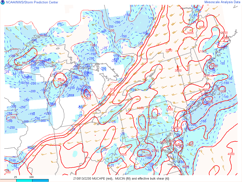 |
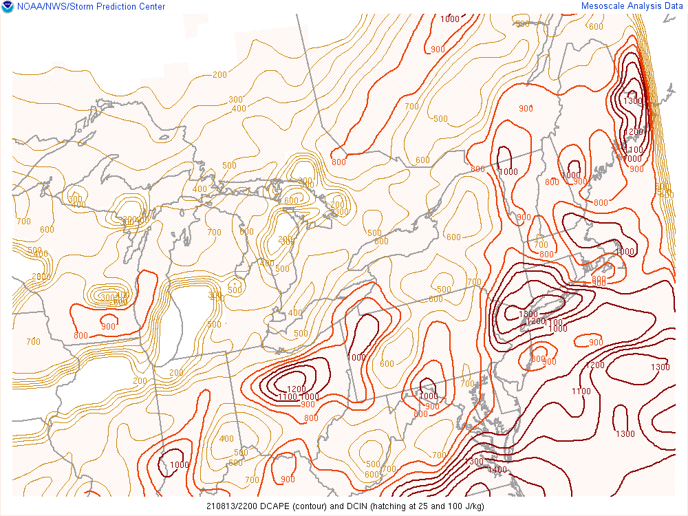 |
| MUCAPE and effective shear on August 13, 2021 at 22Z (6 PM). Note that deep layer shear was a little stronger ahead of an advancing cold front. | DCAPE on August 13, 2021 at 22z (6 PM). Note the increasing values of DCAPE towards the southern portion of the area. |
Each link below shows a CONUS loop from the SPC mesoanalysis, spanning a period from 4Z (midnight) on August 11 through 4Z (midnight) on August 14.
500 mb heights/T’s/winds from SPC Mesoanalysis
MUCAPE and Lifted Parcel Level
 |
Media use of NWS Web News Stories is encouraged! Please acknowledge the NWS as the source of any news information accessed from this site. |
|