Overview
|
The remnants of Tropical Storm Cristobal entered the western Great Lakes region on June 9th, extending a warm front across the Ohio Valley during the evening hours. A hot, moist, and tropical air mass entered the region behind the front for June 10th, resulting in high temperatures in the upper 80s and lower 90s and dew points in the 70s across the region. Heat indices in Northwest Ohio reached the upper 90s before showers and thunderstorms entered during the afternoon hours. This resulted in high instability with surface-based CAPE exceeding 2000 J/kg by early afternoon and eventually surpassing 3000 J/kg ahead of the convection. While the atmosphere was unstable, a cap of 14 degrees Celsius around 750 mb was evident on the 18z sounding from NWS Wilmington, preventing convection from being diurnally-forced during the early afternoon hours. A shortwave trough and associated surface cold front entered from the west, providing the forcing for this event. The cap began to break over western Ohio around 3pm with these synoptic features and shower and thunderstorm activity started getting organized over the region. The mode of storms began as discrete to scattered/clustered cells west of our CWA, eventually congealing into a squall line. This squall line propagated from west to east, though individual cell motion was from south-southwest to north-northeast. The main threat from severe thunderstorms were damaging winds, as evidenced by high DCAPE values up to 1500 J/kg over the region. NWS Cleveland warned for all 30 counties of responsibility for this event as the severe line moved from west to east across the area between 5 pm and midnight. The most impacted areas were in the western portions of the forecast area. Storms produced winds up to 80 mph in the Lake Erie Islands and adjacent mainland areas of Ottawa and Erie Counties in Ohio, with wind damage across Oak Harbor, Catawba Island, Port Clinton, Marblehead, South Bass Island, and Sandusky. Another powerful segment of the line moved across Marion County, including the city of Marion, prompting sporadic damage in the city with winds up to 80 mph. There was one injury with this event. The intensity of the severe line waned as it passed east of Interstate 71, though it still remained severe. As the line moved east of Interstate 77 after dark, the line picked up in intensity again as the storms caught up to the outflow and backed winds ahead of the line rejuvenated the thunderstorms. Some better storms moved across Trumbull and Crawford Counties with pockets of stronger wind damage. There was brief concern for tornadoes in the Mahoning County area as a kink in the line surged north with the flow and there was a tornado just to the south of our forecast area in Columbiana County. However, no tornadoes were confirmed by NWS Cleveland.ned: |
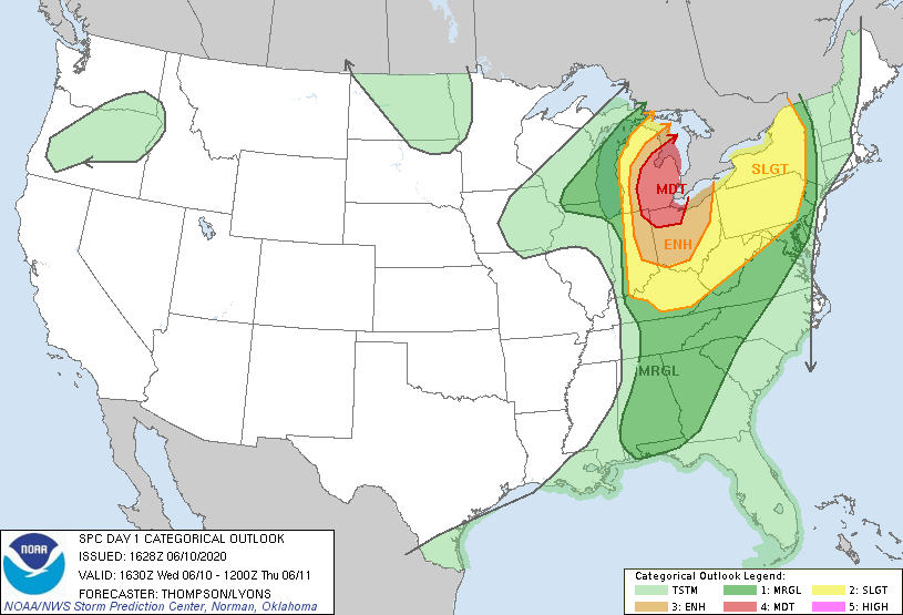 Day 1 convective outlook which shows a large swath of moderate and enhanced risk areas across northern Ohio and eastern Michigan. |
Photos & Video
 |
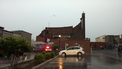 |
| Sandusky State Theater before storm damage. (Google Maps) |
Sandusky State Theater after storm damage. (Credit: Robert Fischer, Jr) |
Radar
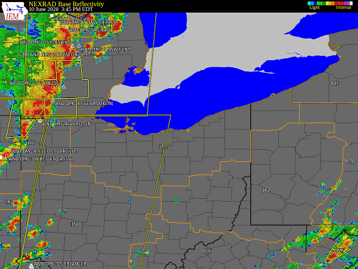 |
| Radar loop showing local storm reports, severe/tornado warnings, and severe thunderstorm watches. |
Storm Reports
 |
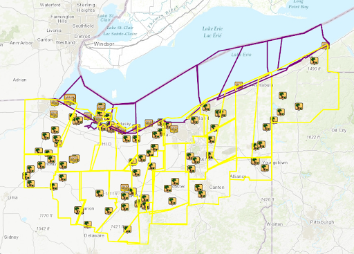 |
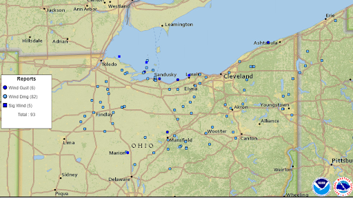
| Figure 1: Map showing local storm reports across the area. Note the several "significant wind" reports, indicated by dark blue boxes. Significant wind reports occur when wind speeds of 75 mph or greater occur. Click here for link to map. | Figure 2: Map showing all of the local storm reports issued on June 10, 2020 as well as all of the convective warnings issued by the Cleveland WFO. Note every county in the county warning area was covered. Click here for link to map. |
Click here for Marion Damage PNS
Environment
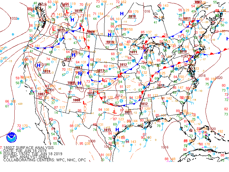 |
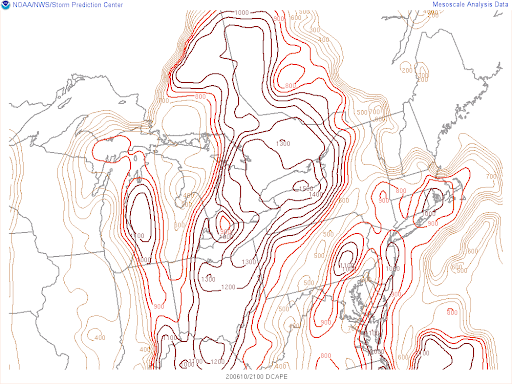 |
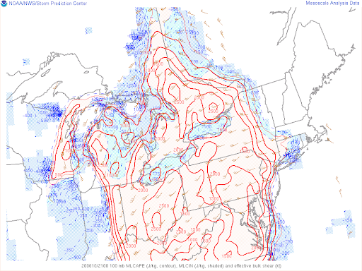 |
| Figure 1: WPC surface analysis on June 10, 2020 at 18Z. | Figure 2: SPC mesoanalysis showing an enhanced corridor of downdraft cape (DCAPE) across the Ohio Valle. Note DCAPE values in excess of 1000 J/kg across the area. | Figure 3: SPC mesoanalysis showing mixed-layer cape (MLCAPE), mixed-layer convective inhibition (MLCIN), and effective bulk shear. Note effective shear values of 40 to 45 knots across the Ohio Valley. |
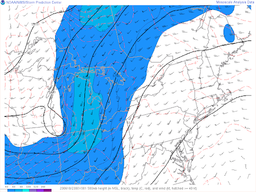 |
| Figure 4: SPC mesoanalysis showing an enhanced corridor of 500 mb south to southwesterly winds. Note the pocket of 60+ knot 500 mb winds across lower Michigan. |
 |
Media use of NWS Web News Stories is encouraged! Please acknowledge the NWS as the source of any news information accessed from this site. |
|

