June 4-6, 2016 featured multiple rounds of severe weather that impacted northern Ohio and northwest Pennsylvania. On June 4th, a warm front moved north across the region bringing widespread rainfall. Immediately with the warm front, a couple isolated thunderstorms developed, one of which became severe and brought an 80-90 mph downburst to a farmstead in Wayne County, Ohio. On June 5th, mostly sunny skies and warm, moist southerly flow allowed for temperatures to reach the mid 80s across the region, ahead of a cold front that moved through northern Ohio and northwest Pennsylvania Sunday afternoon. Thunderstorms developed just after 12pm on the 5th and quickly became strong to severe in nature. One of the first storms of the day was the strongest, bringing a microburst to downtown Sandusky and damaging trees and buildings in the city of Sandusky and downing power poles on the causeway to Cedar Point. Storms pushed eastward on the 5th causing tree damage and power outages to areas of northeast Ohio and northwest Pennsylvania. On June 6th, a secondary low pressure system and cold front moved across the Great Lakes region bringing another round of showers and thunderstorms to the area. Storms mostly remained below severe limits on this day until far northeast Ohio and into northwest Pennsylvania. Kinsman and Vernon Townships in northeast Trumbull County and Summit Township in Crawford County, PA were the hardest hit with widespread tree damage and downed power lines.
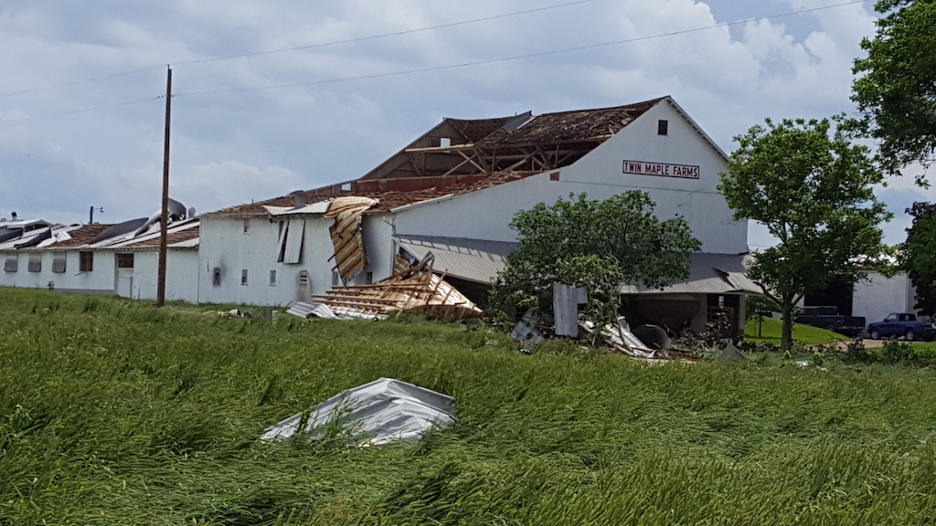
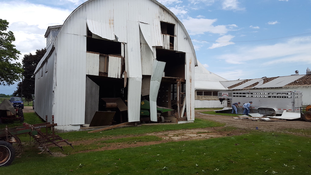
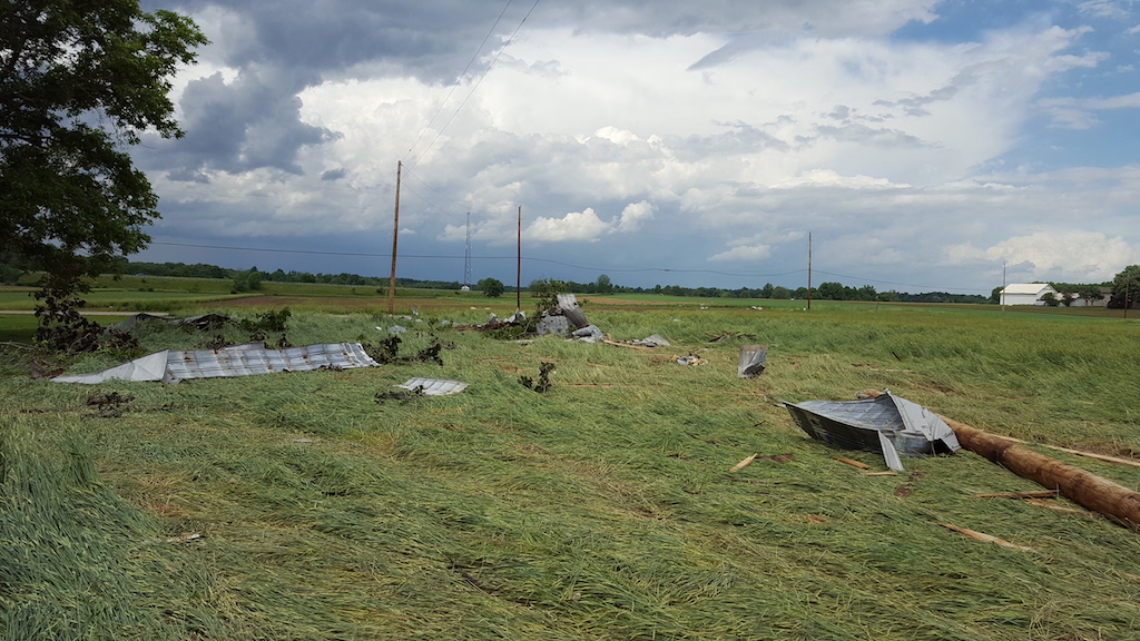
Public Information Statement
National Weather Service Cleveland OH
1148 AM EDT TUE JUN 7 2016

...Microburst/Straight Line Wind Damage Confirmed Near
3 ESE Reedsburg in Wayne County Ohio...

Location...3 ESE Reedsburg in Wayne County Ohio
Date...06/04/2016
Estimated Time...921 PM EDT
Estimated Maximum Wind Speed...80-90 mph
Fatalities...none
Injuries...none

The information in this statement is preliminary and subject to
change up until publication in NWS Storm Data.

...Summary...
The National Weather Service in Cleveland OH has confirmed a
Microburst/Straight Line Wind Damage near 3 ESE Reedsburg in
Wayne County Ohio on 06/04/2016.

At 921 PM a downburst of 80-90 mph produced straight line winds
at a farm. Extensive sections of roofing were ripped away from the
main barn. Roof and wall damage was also noted to other out
buildings. a couple of power poles were knocked down.

Debris was carried mainly in a northerly direction
consistent with a downburst.


For reference...
A microburst is a convective downdraft with an affected outflow
area of less than 2 1/2 miles wide and peak winds lasting less
than 5 minutes. Microbursts may induce dangerous horizontal and
vertical wind shears...which can adversely affect aircraft
performance and cause property damage. Straight-line winds are
generally any wind that is not associated with rotation...used
mainly to differentiate them from tornadic winds.
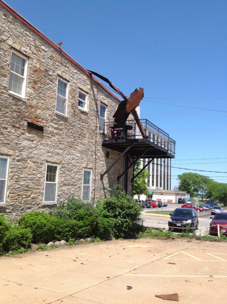
$$

LaPlante
Damage Photos from Event- Courtesy of Wayne County EMA- Joseph Villegas
Public Information Statement
National Weather Service Cleveland OH
311 PM EDT MON JUN 6 2016

...Microburst/Straight Line Wind Damage Confirmed Near
Sandusky in Erie County Ohio...

Location...Sandusky in Erie County Ohio
Date...June 5 2016
Estimated Time...1:32 PM EDT
Estimated Maximum Wind Speed...80 - 90 mph
Maximum Path Width...0.5 miles
Path Length...2.25 miles
* Fatalities...0
* Injuries...0

* The information in this statement is preliminary and subject to
change pending final review of the event(s) and publication in
NWS Storm Data.

...Summary...
The National Weather Service in Cleveland OH has confirmed a
Microburst/Straight Line Wind Damage near Sandusky in Erie
County Ohio on June 5, 2016.

The National Weather Service in Cleveland, Ohio conducted a storm
survey in Sandusky, Ohio this afternoon. Based on the survey, it
was determined that a downburst created the wind damage in the
area Sunday afternoon. The damage consisted mainly of tree
branches with a few uprooted trees. Several power poles were
blown over and broken on the causeway to Cedar Point. It was
estimated that most winds were between 70-80 mph in downtown
Sandusky with winds as high as 80-90 mph on the causeway.

This information can also be found on our website at
weather.gov/cle.

For reference...
A microburst is a convective downdraft with an affected outflow
area of less than 2 1/2 miles wide and peak winds lasting less
than 5 minutes. Microbursts may induce dangerous horizontal and
vertical wind shears...which can adversely affect aircraft
performance and cause property damage. Straight-line winds are
generally any wind that is not associated with rotation...used
mainly to differentiate them from tornadic winds.

$$

Garnet/Stubler
.jpg)
Damage Photos from Event

PRELIMINARY LOCAL STORM REPORT...SUMMARY
NATIONAL WEATHER SERVICE CLEVELAND OH
1127 PM EDT SUN JUN 05 2016

..TIME...   ...EVENT...      ...CITY LOCATION...     ...LAT.LON...
..DATE...   ....MAG....      ..COUNTY LOCATION..ST.. ...SOURCE....
            ..REMARKS..

0133 PM     MARINE TSTM WIND 1 ENE SANDUSKY          41.46N 82.70W
06/05/2016  E60.00 MPH       ERIE               OH   PUBLIC

            LARGE TREES DOWN AT BATTERY PARK MARINA.

0133 PM     TSTM WND DMG     SANDUSKY                41.46N 82.71W
06/05/2016                   ERIE               OH   TRAINED SPOTTER

            LARGE TREES AND LIMBS DOWN WITH SOME FALLING ON BUILDINGS
            CAUSING ROOF DAMAGE. POWER LINES DOWN ON CARS ON CEDAR
            POINT DRIVE.

0232 PM     HAIL             CLYDE                   41.31N 82.98W
06/05/2016  E1.00 INCH       SANDUSKY           OH   TRAINED SPOTTER

0248 PM     TSTM WND DMG     2 SE ELYRIA             41.36N 82.08W
06/05/2016                   LORAIN             OH   TRAINED SPOTTER

            LARGE TREE DOWN ON ROUTE 57 SOUTHBOUND. TREE DOWN ON EAST
            AVENUE AND 16TH STREET.

0304 PM     TSTM WND GST     5 SW CLEVELAND          41.43N 81.75W
06/05/2016  M49.00 MPH       CUYAHOGA           OH   ASOS

            43 KNOT WIND GUST AT CLEVELAND HOPKINS AIRPORT.

0345 PM     TSTM WND DMG     CRANESVILLE             41.90N 80.34W
06/05/2016                   ERIE               PA   TRAINED SPOTTER

            SEVERAL TREES AND LARGE LIMBS DOWN.

0345 PM     TSTM WND DMG     2 NNE AKRON             41.11N 81.51W
06/05/2016                   SUMMIT             OH   PUBLIC

            2 TREES/LARGE BRANCHES DOWN.

0348 PM     FUNNEL CLOUD     CONNEAUTVILLE           41.76N 80.37W
06/05/2016                   CRAWFORD           PA   FIRE DEPT/RESCUE

            FIRE DEPARTMENT REPORTED A POSSIBLE FUNNEL CLOUD NEAR
            TOWN.

0352 PM     TSTM WND DMG     1 NE ANDOVER            41.62N 80.56W
06/05/2016                   ASHTABULA          OH   DEPT OF HIGHWAYS

            SEVERAL TREES AND POWER LINES DOWN NEAR THE INTERSECTION
            OF PYMATUNING LAKE ROAD AND FOOTVILLE-RICHMOND ROAD
            NORTHEAST OF ANDOVER.

0354 PM     TSTM WND DMG     LINESVILLE              41.66N 80.42W
06/05/2016                   CRAWFORD           PA   911 CALL CENTER

            TREE DOWN.

0356 PM     TSTM WND DMG     5 W PARKMAN             41.37N 81.15W
06/05/2016                   GEAUGA             OH   LAW ENFORCEMENT

            TREE DOWN IN TROY TOWNSHIP.

0400 PM     TSTM WND DMG     4 SSW WEST FARMINGTON   41.34N 81.01W
06/05/2016                   PORTAGE            OH   UTILITY COMPANY

            TREES DOWN.

0400 PM     TSTM WND DMG     PARKMAN                 41.37N 81.06W
06/05/2016                   GEAUGA             OH   LAW ENFORCEMENT

            TREE DOWN.

0405 PM     TSTM WND DMG     2 WSW BRISTOLVILLE      41.36N 80.91W
06/05/2016                   TRUMBULL           OH   UTILITY COMPANY

            TREES DOWN.

0409 PM     TSTM WND DMG     UNION CITY              41.90N 79.84W
06/05/2016                   ERIE               PA   LAW ENFORCEMENT

            TREES AND POWER OUTAGES WITH TREE DEBRIS ON ROADWAYS.
            FLAGPOLE SNAPPED.

0418 PM     TSTM WND DMG     TOWNVILLE               41.68N 79.88W
06/05/2016                   CRAWFORD           PA   911 CALL CENTER

            TREES DOWNED.

0424 PM     TSTM WND DMG     SPARTANSBURG            41.82N 79.68W
06/05/2016                   CRAWFORD           PA   911 CALL CENTER

            TREES DOWNED.

0430 PM     TSTM WND DMG     2 N ORANGEVILLE         41.37N 80.53W
06/05/2016                   TRUMBULL           OH   BROADCAST MEDIA

            TREES DOWN IN BURGHILL.

0440 PM     TSTM WND DMG     HYDETOWN                41.65N 79.72W
06/05/2016                   CRAWFORD           PA   911 CALL CENTER

            TREES DOWNED.
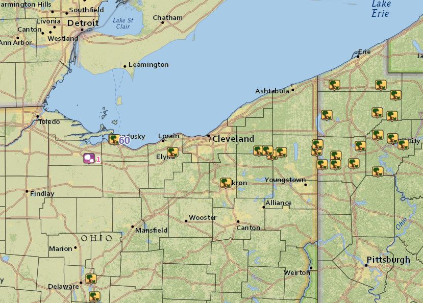
Map of Storm Reports
PRELIMINARY LOCAL STORM REPORT...SUMMARY
NATIONAL WEATHER SERVICE CLEVELAND OH
1236 AM EDT TUE JUN 07 2016

..TIME...   ...EVENT...      ...CITY LOCATION...     ...LAT.LON...
..DATE...   ....MAG....      ..COUNTY LOCATION..ST.. ...SOURCE....
            ..REMARKS..

0936 PM     TSTM WND DMG     PARKMAN                 41.37N 81.06W
06/06/2016                   GEAUGA             OH   911 CALL CENTER

            GEAUGA COUNTY DISPATCH REPORTED TREES AND POWER LINES
            DOWN IN THE COUNTY...MOSTLY IN SOUTHERN PORTIONS. OHIO 88
            WAS CLOSED NEAR PARKMAN DUE TO DOWNED TREES.

0955 PM     TSTM WND DMG     CORTLAND                41.33N 80.72W
06/06/2016                   TRUMBULL           OH   911 CALL CENTER

            MANY DOWNED TREES ACROSS TRUMBULL COUNTY. MOST REPORTS
            ARE FROM THE CORTLAND AND HOWLAND AREAS IN THE CENTRAL
            PART OF THE COUNTY.

1007 PM     TSTM WND DMG     2 S KINSMAN             41.42N 80.60W
06/06/2016                   TRUMBULL           OH   FIRE DEPT/RESCUE

            TREE DAMAGE ACROSS MUCH OF KINSMAN AND VERNON TOWNSHIPS
            BETWEEN THE ASHTABULA COUNTY LINE SOUTH TO THE
            INTERSECTION OF OHIO ROUTES 7 AND 88 IN NORTHEASTERN
            TRUMBULL COUNTY. AT LEAST A DOZEN TREES DOWN AND MANY
            POWER LINES DOWN INCLUDING LINES ON A CAR. NO STRUCTURAL
            DAMAGE REPORTED.

1035 PM     TSTM WND DMG     2 ENE CONNEAUT LAKE     41.63N 80.27W
06/06/2016                   CRAWFORD           PA   911 CALL CENTER

            CRAWFORD COUNTY DISPATCH REPORTED TREES AND POWER LINES
            DOWN IN SUMMIT TOWNSHIP.
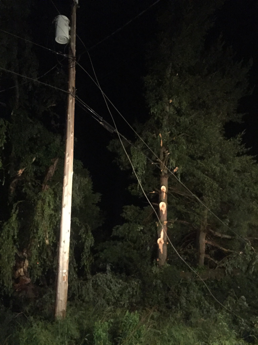
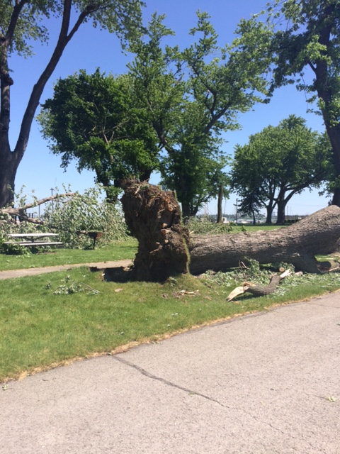
Photo of Tree and Power Line Damage in Northeast Trumbull County- Courtesy of Burghill/Vernon Fire