map background: Google
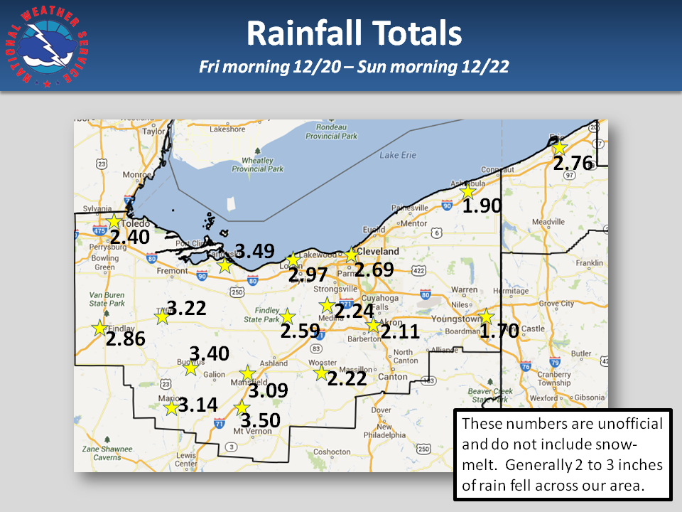
These numbers are un-official and do not include snow melt. Generaly 2 to 3 inches of rain fell across our area.
| City | Rainfall (inches) |
|---|---|
| Toledo | 2.40 |
| Findlay | 2.86 |
| Tiffen | 3.22 |
| Marion | 3.14 |
| Mt. Vernon | 3.50 |
| Mansfield | 3.09 |
| Bucyrus | 3.40 |
| Findlay State Park | 2.59 |
| Medina | 2.24 |
| Wooster | 2.22 |
| Akron | 2.11 |
| Lorain | 2.97 |
| Sandusky | 3.49 |
| Cleveland | 2.69 |
| Youngstown | 1.70 |
| Ashtabula | 1.90 |
| Erie, PA | 2.76 |

| Time | Speed | Location | County | State | Lat | Lon | Comments | ||||
|---|---|---|---|---|---|---|---|---|---|---|---|
| 400 | UNK | LA RUE | MARION | OH | 40.58 | -83.38 | SILO DAMAGED NEAR LA RUE. TIME ESTIMATED FROM RADAR (CLE) | ||||
| 420 | 60 | 6 SE BUCYRUS | CRAWFORD | OH | 40.74 | -82.89 | POLE BUILDING DESTROYED IN NEW WINCHESTER. (CLE) | ||||
| 434 | UNK | MARION | MARION | OH | 40.58 | -83.13 | NUMEROUS TREES AND SEVERAL POWER LINES DOWN IN AND AROUND MARION. SEMI BLOWN OVER IN THE VICINITY OF MARION. (CLE) | ||||
| 435 | UNK | SHELBY | RICHLAND | OH | 40.88 | -82.66 | WIDESPREAD TREES DOWN AND POWER OUTAGES. FOUR BUILDINGS DAMAGED ESPECIALLY THE NORTH END OF TOWN...NEAR ROUTE 96 AND 13. (CLE) | ||||
| 500 | UNK | MANSFIELD | RICHLAND | OH | 40.76 | -82.53 | NUMEROUS TREES DOWN IN VICINITY OF MANSFIELD. (CLE) | ||||
| 500 | UNK | SULLIVAN | ASHLAND | OH | 41.03 | -82.22 | ROOF TORN OFF BUILDING. 2 PEOPLE TRAPPED INSIDE BUILDING. (CLE) | ||||
| 510 | UNK | VALLEY CITY | MEDINA | OH | 41.24 | -81.93 | ONE TREE KNOCKED TREE. (CLE) | ||||
| 515 | UNK | MANSFIELD | RICHLAND | OH | 40.76 | -82.53 | MULTIPLE TREES DOWN. PORTION OF A BARN BLOWN DOWN. 3 BUILDINGS DESTROYED. (CLE) | ||||
| 525 | 60 | WOOSTER | WAYNE | OH | 40.82 | -81.93 | (CLE) | ||||
| 538 | 60 | WOOSTER | WAYNE | OH | 40.82 | -81.93 | CHRISTMAS LAWN DECORATIONS BLOWN AWAY. (CLE) | ||||
| 600 | UNK | 5 W BURTON | GEAUGA | OH | 41.47 | -81.24 | ONE TREE DOWN IN NEWBURY. (CLE) | ||||
| 605 | UNK | APPLE CREEK | WAYNE | OH | 40.75 | -81.83 | A COUPLE OF TREES DOWN. (CLE) | ||||
| 605 | UNK | BURTON | GEAUGA | OH | 41.47 | -81.15 | LARGE LIMB DOWN. (CLE) | ||||
| 615 | UNK | 5 E MILLERSBURG | HOLMES | OH | 40.55 | -81.82 | A FEW TREES DOWN. (CLE) | ||||
| 615 | UNK | WOOSTER | WAYNE | OH | 40.82 | -81.93 | MANY TREES DOWN ACROSS THE COUNTY. (CLE) | ||||
| 640 | UNK | 5 E CANTON | STARK | OH | 40.81 | -81.28 | A FEW TREES DOWN. (CLE) | ||||
| 700 | UNK | 5 S MILLERSBURG | HOLMES | OH | 40.48 | -81.92 | COUPLE OF TREES DOWN. (CLE) | ||||
| 700 | UNK | YOUNGSTOWN | MAHONING | OH | 41.1 | -80.65 | TREE FELL ON HOUSE. (CLE) | ||||
| 705 | UNK | MOUNT VERNON | KNOX | OH | 40.39 | -82.48 | TWO TO THREE TREES DOWN IN THE COUNTY. (CLE) | ||||


|
Woodville crested at 14.13 feet (major flooding) |
Waterville crested at 11.83 feet (minor flooding) |
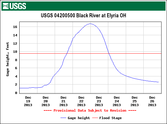
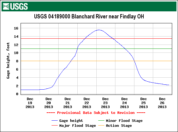
| Elyria crested at 16.77 feet (moderate flooding) | Findlay crested at 15.37 feet (major flooding) |
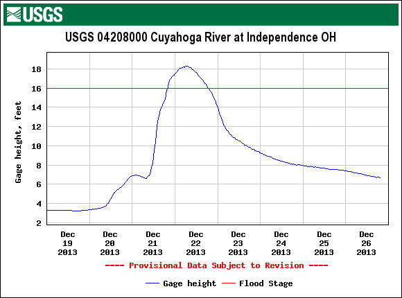

| Independence crested at 18.25 feet (moderate flooding) | Killbuck crested at 16.62 (minor flooding) |


| Milan crested at 22.15 feet (moderate flooding) | North Industry crested at 9.34 feet (minor flooding) |
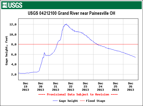
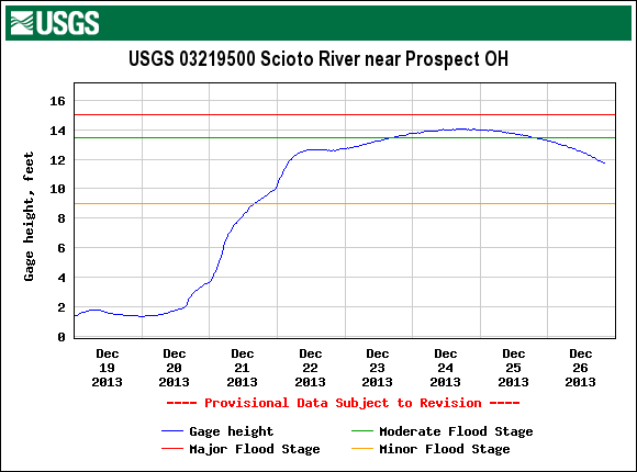
| Painseville crested at 12.06 feet (minor flooding) | Prospect crested at 14.06 feet (moderate flooding) |


| Willoughby crested at 11.88 feet (minor flooding) | Meadville crested at 14.16 feet (minor flooding) |

