Notable Weather Events of 2010
February Cranks Up the Snow...
A number of major winter weather systems affected the Ohio Valley region in February. Over the course of just about 3 weeks, northern Ohio and northwest Pennsylvania felt the effects of five significant weather systems. This put 2010 into the record books at all six of our climate stations (Toledo, Mansfield, Cleveland, Akron-Canton, Youngstown, Erie PA). It was the snowiest February on record in Akron-Canton with 37.2 inches, in Mansfield with 49.2 inches, and in Youngstown with 36.3 inches. The other locations made the top ten lists of snowiest Februarys.
Flip the Switch and Winter is Over...
While February made the snow record books, March began a stretch of 6 months of temperatures that were well above average. At that point though, you held your breath waiting for the pattern to shift. April can bring any assortment of weather conditions.
Early April's Record Warmth...
The spring equinox had just passed two weeks prior, but the weather maps looked more like summer. The area hit 80 degrees or better for the first several days in April. This broke daily records at the climate stations. New record high temperatures were established on 4 days within the first week in April at Cleveland, Mansfield, and Youngstown. The warmest temperature was 87 degrees at Youngstown on the 2nd and the 6th. It was the warmest April on record for Cleveland with an average temperature of 56.0 degrees. This topped the previous record of 55.9 degrees set in 1955.
Severe Weather Breaks Out in May...
An outbreak of severe weather on May 7th and 8th brought the first tornado of the year. This tornado touched down in Montgomery Township in Wood County in northwest Ohio during the evening of May 7th. A damage survey determined that this tornado was an EF1 rating. This tornado would just be the first of 13 to affect the NWS CLE area of responsibility. On average, our area will get impacted by 8 tornadoes. It turned out to be an above average year across Ohio. The average number of tornadoes in any given year is 16. This year had 42!

June Becomes a Deadly Month...
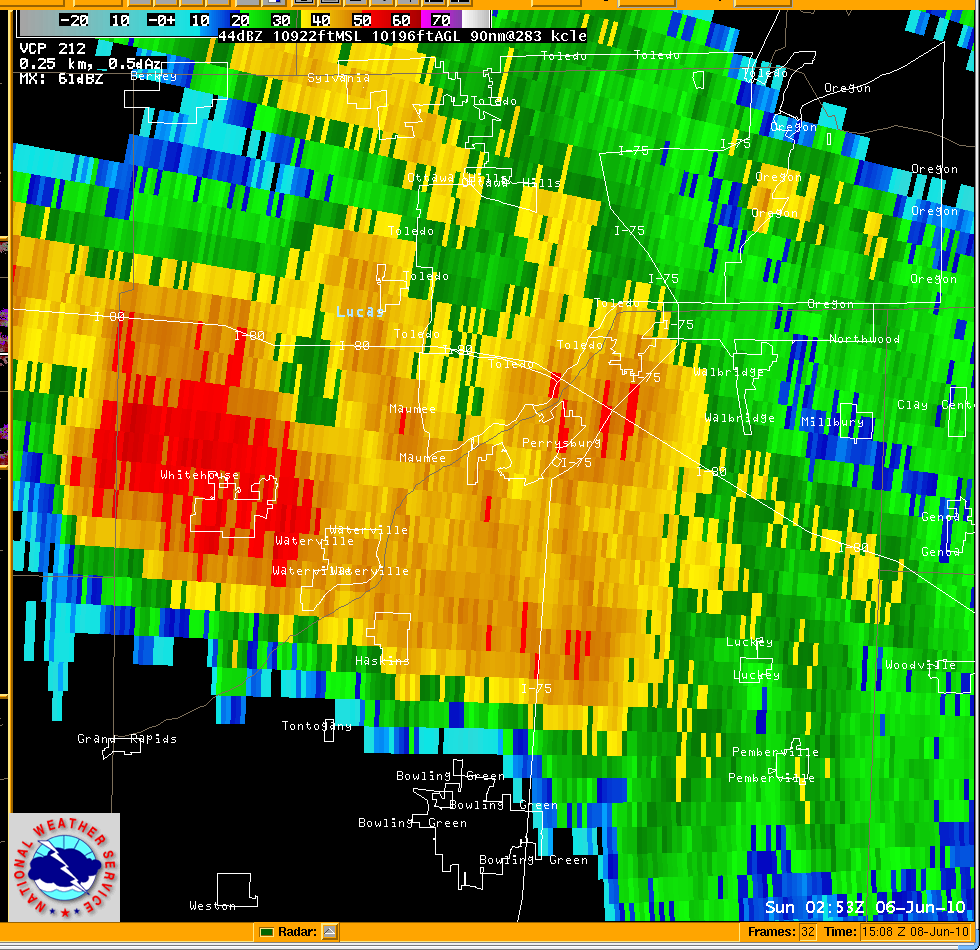
Northwest Ohio was the focus of a rare EF4 tornado on June 5th. Only a small percentage of tornadoes become that large. Wind speeds were estimated to be 170 MPH. The width of this tornado was up to four football fields at some points during its 10 mile path. Unfortunately this tornado that struck just before midnight took 7 lives. Five other tornadoes touched down in northern Ohio and northwest PA between June 5th and 6th.
The images above are from 1053 PM June 5th. The left image is the radar reflectivity and the image on the right is the radar storm relative velocity. Click on either of the images to see a sequence of radar imagery from this storm that produced the EF4 tornado.
The map below shows the path of the tornado. Click on the map to open an interactive page that will allow you to view a description and survey pictures at each of the place markers or click here.
|
|
|
| Survey Picture Page |
Summer Heat Made It Into the Record Books...
Preliminary numbers had placed Ohio’s summer as the 4th warmest on record, but after the final numbers were in and analyzed, Ohio had their 2nd warmest summer on record. There were 21 days with 90 degrees or better in Toledo between June, July, and August (JJA). Cleveland was toasty too with sixteen 90 or better days during the same period. The normal number of 90+ days in JJA is 12 for Toledo and 8 for Cleveland.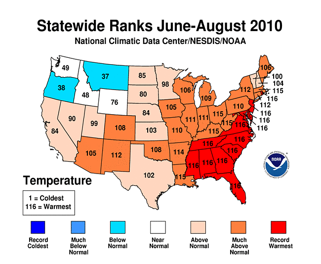
All of the warmth did not necessarily result in overly dry weather. Mansfield made it into the record books with 8.88 inches of rain in June. This would be the third wettest June for Mansfield. The area overall had near to slightly above normal precipitation during the summer.
The Warmth Continued Into Autumn...
The region was still hitting 90+ degrees in late September and breaking records. It was 92 degrees in Toledo on the 23rd and 90 degrees in Cleveland on the 24th.
Cool weather of any sort was a distant memory. The January through August 2010 period ranked as the 15th warmest on record for the state of Ohio. It was 6th warmest in Pennsylvania. For the year to date at the end of September, Cleveland was on target to have its warmest year on record.
 A Wooster family escaped an EF2 tornado that devastated the community and severely damaged their home; crediting NOAA All Hazards Weather Radio for their decision to head for safety. This tornado had a path length of 12 miles and damaged property of the Ohio Agricultural Research and Development Center. It was the second largest tornado of the year in NWS CLE area of responsibility. For more information on NOAA All Hazards Weather Radio click here. A Wooster family escaped an EF2 tornado that devastated the community and severely damaged their home; crediting NOAA All Hazards Weather Radio for their decision to head for safety. This tornado had a path length of 12 miles and damaged property of the Ohio Agricultural Research and Development Center. It was the second largest tornado of the year in NWS CLE area of responsibility. For more information on NOAA All Hazards Weather Radio click here.
The Pattern Shifts...
While November squeaked by with only a trace of snow reported at Cleveland, Youngstown, and Mansfield, the weather pattern shifted and a few lake effect snow events turned December around. For the first time in nearly a year, the region felt temperatures that were well below normal. December in Cleveland finished nearly 5 degrees below normal. While there was only 12.7 inches of snow recorded at Cleveland Hopkins Airport, much more fell across the snowbelt of northeast Ohio and northwest PA. The period from December 5th through the 9th brought locally 3 feet to some snowbelt. communities. There was even a report in Crawford county PA of 4 feet this particular week. Heavy lake effect snow fell in downtown Cleveland as well. On the 8th, 10 inches fell on city streets bringing the city to a standstill.
The forecast seemed to repeat itself the following week with another round of lake-effect snow. Heavy lake-effect snow fell from December 12th through the 15th. There were local amounts of 2 feet this week.
At the Close of 2010...
Contrary to the rest of the month, the last day of the year was 20-25 degrees above normal across the area. Low temperatures were in the 40s and highs were in the 50s.
Monthly Records...
A number of monthly temperature and precipitation records occurred across our climate sites this year.
All of these monthly statistics for our climate stations can be found year around by going to the following link and selecting your station. Data each month are updated within a week if data for the previous month made the "top ten."
NWS Cleveland Unique Local Climate Data
Annual/Yearly Records...
There was only one site where 2010 made it onto an annual top ten list. Despite Cleveland running in the number one slot on the top ten list of warmest years on record, the cold end to the year dropped them down to the 8th position, tied with 1973 with 52.6 degrees. The warmest year on record at Cleveland still stands at 53.5 degrees from 1998.
Records that encompass yearly totals such as the wettest/driest/snowiest years on record are again located on our Unique Local Climate Data page (follow the link above).
|
|
Toledo
|
Mansfield
|
Cleveland
|
Akron-Canton
|
Youngstown
|
Erie, PA
|
|
2010 precipitation/
departure from normal
|
34.60”
+1.39”
|
38.27”
-4.96”
|
35.40”
-3.30”
|
37.85”
-0.62”
|
38.80”
+0.78”
|
40.00”
-2.77”
|
|
2010 average temperature/ departure from normal
|
51.7
+2.2
|
50.5
+1.7
|
52.6
+2.9
|
51.0
+1.5
|
50.4
+1.9
|
50.5
+0.6
|
Memorable Weather Events...
View our growing local weather events page highlighted below.
Local Weather Events and Local Interest Features Page
The publication, StormData, can be found with the National Climatic Data Center.
Worldwide Climate Anomalies and Events...
Significant Global Climate Events and Anomalies 2010
NCDC 2010 Preliminary Annual Global Climate Report
Additional Notes...
All data are considered preliminary. The National Climatic Data Center finalizes and stores the official record of all of our weather data. Period of record are as follows:
Records date back to 1874 for Erie
1897 for Youngstown
1871 for Canton-Akron, Cleveland, and Toledo
1916 for Mansfield
|


