Notable Weather Events of 2008
Starting off 2008...
New Year’s Day 2008 started off with a wintry mix of precipitation that changed over to all snow and accumulated several inches. Cleveland and Youngstown each reported over 5 inches of snow (5.3 and 5.6 inches of snow, respectively). This storm system also produced gusty winds of 30 to 45 mph which produced brief blizzard conditions.
There were several other systems that caused windy conditions in January. Cleveland gusted above 60 mph twice in the month of January (the 9th and the 30th). On the 9th thunderstorms brought down trees and damaged some homes. The highest gust was estimated at 85 mph from straight line thunderstorm winds in Huron County. On the 30th another round of severe thunderstorms brought gusts above 60 mph to the area. Record high temperatures were broken on January 9th with temperatures in the 60s.
Snowy March...
Winter 2008 did not want to give up. January had below normal snow but February and March came back with snowfall that elevated February and March of 2008 into their respective ‘top ten’ snowiest months on record. February 2008 was the snowiest on record for Youngstown with 31.7 inches. March snowfall ranked number one for Cleveland (30.4 inches), Erie (33.9 inches), and Mansfield (21.4 inches). One wild March week stands out in particular.

The week started with above normal readings. Temperatures shot into the lower 60s on March 3rd. Conditions changed quickly and by the next day temperatures dropped below freezing and winter was back. During the evening hours of March 4th moderate to heavy freezing rain fell with thunder and lightning reported by trained weather spotters! A glaze of ice quickly accumulated on surfaces causing numerous accidents. By the overnight hours the precipitation had changed from freezing rain to sleet to snow. Fair weather Thursday was the calm before the next winter storm.
The week ended with a significant and widespread snowstorm from the 8th to the 9th. Ten to twenty inches of snow fell across the entire area. The snow began before noon on Friday and persisted across much of the area into Saturday, mixing with sleet and freezing rain at times across far eastern Ohio. What a week in northern Ohio and northwest Pennsylvania!
Arcadia/Fostoria (May 31st) Tornado...
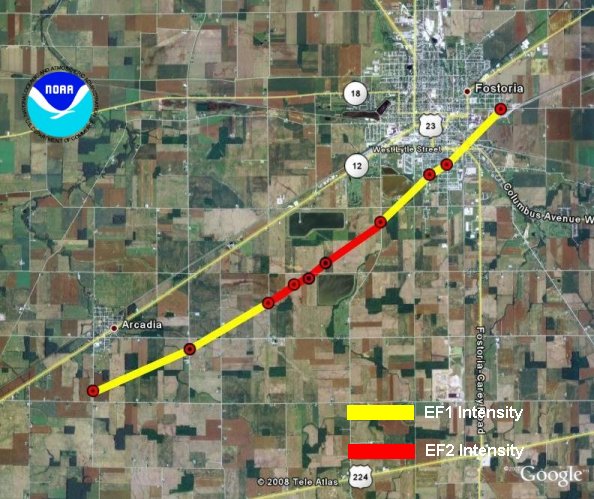
In northeast Hancock County, east of Arcadia, there were 10 homes severely damaged from a tornado that touched down on May 31st. The second floor was taken off of several homes. The tornado was rated an EF1 at the beginning and grew into an EF2 southeast of Arcadia with winds up to 130 MPH . The tornado ended on the south side of Fostoria as an EF1. The damage path was just over eight miles and amounted to $1.75 million dollars. There were 10 minor injuries from this tornado. This was to be one of only two tornadoes for the entire year! We average 8 tornadoes each year.
Three Days of Hail Boosts Severe Event Total...
The weekend of June 21st through the 23rd had daily thunderstorms that contained severe hail. The National Weather Service in Cleveland received over 100 reports of large hail. The largest hail was the size of golf balls!

Almost a month later, on July 26th, severe thunderstorms dumped tennis ball sized hail on Canton and Massillon! Damage from that storm was at least $100 million.


For the year, the National Weather Service in Cleveland received 454 reports of severe weather from thunderstorms. This is the second highest number of severe thunderstorm events ever reported! This includes reports of large hail and wind gusts as well as the area’s two tornadoes. The record number of events was 470 in 1998. These numbers far exceed the 10 year average of 335 events and 2007’s 294 events. A large number of the 2008 reports were due to large hail.
That near record number of events this past year fell on fewer days than usual. The region had 36 days in 2008 when severe thunderstorms occurred somewhere in the local area.. Typically, this region has near 50 days of severe thunderstorms a year. We never had a fall severe weather event this year. There was a minimum in severe weather from August 19 through December 27th when the area had no severe thunderstorms.
Late Summer Dry Spell Leads to Drought...
The summer started out wet, but it did not take long for drought conditions to develop during the peak of the growing season, mainly across portions of the northwestern Ohio. Between mid-July and mid-September, locations from Bowling Green to Norwalk to Sandusky recorded less than 2 inches of rainfall, significantly reducing crop yields in the area according to local farm bureau agencies. By September, this area was officially designated by the U.S. Drought Monitor as “D1” drought status, which is considered a moderate drought. When a region reaches this stage of drought, some damage to crops is likely. Streams, reservoirs and wells are typically lower than normal. Between July 10 and September 10th, Toledo had received only 44% of normal precipitation (2.64 inches observed vs. 6.03 inches normal). Elmore, located in Ottawa County, received only 1.15 inches during this time. The “drought-buster” rainfall finally came on September 13 when a stationary front brought heavy rainfall across northwest Ohio. Toledo recorded 2.01 inches of rain that day. There was enough rainfall across the area to replenish ground water to a level better than D1 drought status, abnormally dry. However, the damage had already been done to area corn and soybean crops.

Hurricane Ike Remnant Blows Through the Region...
Hurricane remnants can occasionally be a threat to northern Ohio and northwest Pennsylvania. More often they bring the threat of heavy rainfall as they track northeast across the area. On Sunday morning, September 14th, the remnants of Ike interacted with a mid-latitude upper trough located over the upper Mississippi Valley. The trough had an intense upper level jet streak, located over the Great Lakes and southern Ontario. This produced favorable conditions for the remnants of Ike to move rapidly northeast and maintain strength or even intensify across the Ohio Valley on Sunday. The remnants of Ike exhibited the typical behavior of an extra-tropical system with heavy rain to the west of the storm center track (with flooding across the Chicago region) and strong winds with little precipitation to the east of the track (across Ohio). Strong winds from the remnants of Ike spread into southwestern Ohio Sunday morning and across the central and northeast counties by late afternoon. The strong winds persisted for three to four hours across the state and produced considerable wind damage. Trees were flattened in a corridor extending from southwest Ohio into the north central counties. Damage estimates from Ike were over $300 million in northern Ohio alone! Unfortunately there were also two deaths and several injuries with the system. 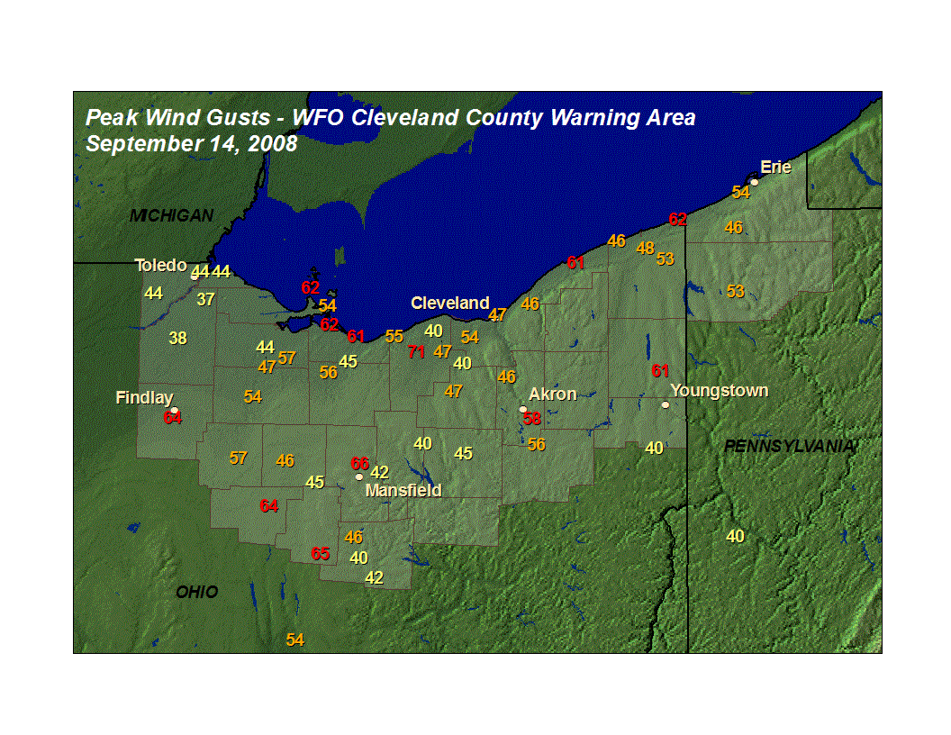
Autumn Snows ...
The snow fell fast and furious this fall. Erie Pennsylvania, which averages nearly 92 inches of snow a year, already had 70 inches of snow by the end of 2008! Inland, across the higher terrain, where the heavier snows typically occur, season-to-date (12/31/08) snow fall totals were impressive. Franklin Center, southwest of Erie, had 117.8 inches of snow (so far). Amity Township in southeast Erie County had received 96.6 inches. Thanks to our dedicated volunteer snowfall observers that step out into the snow twice a day to give us their snowfall measurements!
A snowy start to the winter is not necessarily an indication as to how the rest of the winter will turn out. By this time last season (end of December 2007), Erie had just 23.3 inches and still ended with 118.7 inches of snow for the '07-'08 season. Franklin Center's total as of December 2007 was 35.9 inches and they ended up with 168.8 inches. Amity Township had 32 inches at the end of December 2007 and had 115.5 inches for the season. We will see what the rest of this season brings!
Monthly Records...
February and March gathered most of the monthly precipitation records for 2008. It was the wettest February on record for both Mansfield and Youngstown with 6.05 inches and 5.83 inches, respectively. Akron-Canton, Toledo, Cleveland, and Erie, PA all came in with greater than 5 inches of precipitation which put February into their top ten. Enough of that precipitation fell as snow at the Akron-Canton Airport to make February 2008 number one! They received 25.8 inches of snow in February 2008 breaking their previous record from 1910 by a half inch. Youngstown-Warren also saw a record February with 31.7 inches of snow. That broke the previous record of 26.4 in 2003. The February snowfall, along with the 21.7 inches in March (2008 March placed 4th), helped to set a new seasonal snowfall record for the winter of 2007-2008 at Youngstown with an all time record of 102.8 inches! This snapped the previous record of 90.2 inches which was set just one season prior!
Cleveland, Mansfield and Erie, PA all had their snowiest Marches on record this year. Mansfield had 21.4 inches helping to get their ’07-’08 seasonal total to the number three slot with 79.6 inches. Cleveland received 30.4 inches this past March and Erie had 33.9 inches.
August was dry for Akron-Canton and Mansfield. Akron-Canton only had 1.12 inches of rain placing it 7th driest. Mansfield’s August came in at number three with a meager 0.72 inches.
April 2008 reached into the 'top tens' of a few locations for temperatures. Erie's April was 7th warmest with an average temperature of 51.2 degrees. April was 9th warmest for Youngstown (51.9 degrees) and 10th warmest for Cleveland (52.3 degrees).
All of these monthly statistics for our climate stations can be found year round by going to the following link and selecting your station. Data each month are updated within a week if data for the previous month made the "top ten."
NWS Cleveland Unique Local Climate Data
Annual/Yearly Records...
Four of our six climate sites had precipitation for the year that made the top ten records. Toledo recorded the 6th wettest year on record with 41.71 inches which is 8.50 inches above normal. Erie had the 7th wettest year on record with 49.44 inches (6.67 inches above normal). Cleveland and Youngstown also made the record books for this year.
Annual temperatures at all of our sites came in within a degree of normal. Cleveland had an average temperature of 50.3 degrees for the year and that is only 0.6 degrees above normal. Toledo averaged 49.4 degrees and was only 0.1 degree below normal.
Records that encompass yearly totals such as the wettest/driest/snowiest years on record are again located on our Unique Local Climate Data page (follow the link above).
Memorable Weather Events...
Summaries of major events are found year-round on our: Local Weather Events and Local Interest Features Page. The publication, StormData, can be found with the National Climatic Data Center.
Worldwide Climate Anomalies and Events...
Significant Climate Events and Anomalies 2008
NCDC 2008 Preliminary Climate Report
Additional Notes...
All data are considered preliminary. The National Climatic Data Center finalizes and stores the official record of all of our weather data. Period of record are as follows:
Records date back to 1874 for Erie
1897 for Youngstown
1871 for Canton-Akron, Cleveland, and Toledo
1916 for Mansfield
|