August 19-21, 2007Flash Flooding, River Flooding, and Severe Weather primarily Hancock, Wyandot, Crawford, and Richland Counties |
Flash Flooding and River Flooding |
|
Heavy rainfall inundated multiple communities across northern Ohio during a 2-day period. The rain developed along a nearly stationary frontal boundary which was oriented from west to east across north central Ohio. Moisture from the Gulf of America as well as the remnants of Tropical Depression Erin were being drawn northward and resulted in tropical downpours. Several short wave troughs spurred the development of the showers and storms. A low level jet focused the rains over the same area for hours. The low level jet is most prominent at night so the heaviest rains redeveloped each night, starting Sunday night (August 19th) into Monday morning and then again on Monday night into the early morning hours of Tuesday, August 21st. The heavy rain potential prompted the issuance of a Flood Watch early on Sunday morning. The watch was initially just for Sunday, but was extended into Tuesday as the heavy rains redeveloped. A swath of moderate to heavy rain occurred from Toledo to Cleveland on Sunday with one to two inches of rainfall reported along the south shore of Lake Erie. Further south, amounts were lighter and were generally under a half inch on Sunday. On Monday the situation worsened. Thunderstorms developed along the front late Sunday night and Monday morning. The heaviest rain shifted just south of the Ohio Turnpike and occurred from Wood county in northwest Ohio through Seneca and Huron counties to southern Medina and Summit counties. Three to five inches of rain were commonly reported by Monday afternoon and localized flooding occurred in these areas. Hardest hit were areas of Sandusky and Huron Counties where roads were closed and hundreds of basements were flooded. Significant local flooding also occurred in Medina and Summit County. There was a brief break in the rainfall Monday evening, but thunderstorms began redeveloping again Monday night and were even heavier. Again, the heavy swath of rain shifted a bit further south, and stretched from near Findlay in Hancock county to Upper Sandusky and Bucyrus to near Mansfield in Richland County. Rainfall amounts were incredible. Bucyrus in Crawford County was the center of attention with 8.68 inches falling in less than 24 hours. Large portions of the city were under water from runoff and from the rising Sandusky River. Some residents said it was the worst flooding they could remember in Bucyrus. Other areas with flooding from Monday night's rain included Hancock County where Interstate75 was closed. Runoff from the Blanchard River and other streams caused major flooding in Findlay. Portions of Shelby and Mansfield as well as other parts of Richland County were under water. Significant flooding also occurred in Wyandot County. Public Information Statements on Rainfall issued Monday issued Tuesday |
|
Radar Estimated Precipitation |
Radar Estimated Precipitation
|
From Drought to Saturated Grounds |
|
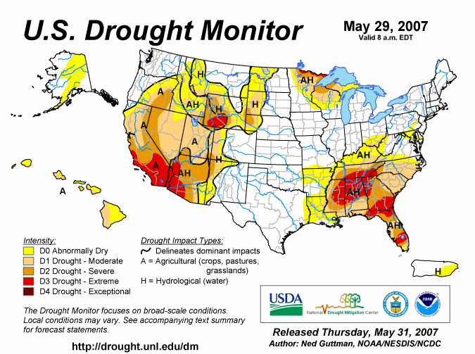
Drought conditions began developing in May when a strong ridge aloft closed the door to precipitating weather systems.
The dry weather continued into the early summer months and drought conditions began emerging. Cleveland recorded its second driest May on record with only 0.66 inches the entire month. By early June portions of the area were being classified as abnormally dry and by early July the status worsened and portions of northern Ohio were placed in the moderate drought category on the U.S Drought Monitor.
Much of Ohio experienced drought conditions the first half of the summer with some western and southern counties being ther driest. In fact, Findlay recorded its driest May through July period on record. From May through July this year, Findlay only received 3.98 inches breaking the previous record of 4.32 inches in 1988. During the first three weeks of August (from the 1st through the 21st), the city has received nearly three times more rain than had fallen from May through July. As of August 21 Findlay recorded 7.12 inches for the month. The drought situation was quickly resolved when a frontal boundary stalled across the area for several days in mid-August. Moisture from the Gulf of America and from the remnants of Tropical Storm Erin fed this system. Now any rivers, creeks, and streams in the area are swollen and cities and towns such as Findlay, Bucyrus, Galion, Mansfield, Carey, and Shelby have flood waters through town. The Blanchard River near Findlay had risen to near its record stage on Wednesday afternoon. That record flood is 18.5 feet and dates back to 1913. NASA's Goddard Space Flight Center was able to capture images by satellite taken before and after the the flooding. Blanchard River is not typically a river visible from this satellite, but with all of the flooding, it is easily visible in this top image. 
For the lastest river stage and forecast information, please go to our NWS CLE AHPS page. |
F1 Tornado |
|
|
||||||||||||||||
|
The damage was a combination of both downburst winds and a tornado. There was clear evidence of a tornado in at least two locations along the path. The initial tornado touchdown most likely occurred in extreme northeast Morrow county just northeast of Shauck. The tornado moved quickly into western Richland county near Kings Corners. EF1 tornado damage was observed at two farms and a forested area along the road of Kings Corners West. The path of the storm continued from near Kings Corners and State Route 42 southeast across State Route 546. Tornado damage was also took place at a home near the corner of Mock Road and Mill Run. After this point the damage appeared to have more of a downburst characteristic as it moved southeast along Mock Road to near Bellville. |
|||||||||||||||||