Richland, Ashland F1 Tornado |
|||||||||||||||||||||||
|
An F1 tornado touched down southwest of Pleasant Hill Lake around 3:40 PM. The tornado tracked east along Pleasant Hill Road and into southwest Ashland County. The tornado had a damage path approximately two miles long in Richland County and four miles long in Ashland County. This damage path was intermittent and no more than fifty yards in width. A barn was leveled and a grain elevator was destroyed along Pleasant Hill Road. Numerous trees were also down in both counties. The tornado moved into Mohican State Forest in Ashland County and dissipated. |
||||||||||||||||||||||
|
|||||||||||||||||||||||
Flash Flooding |
|||||||||||||||||||||||
|
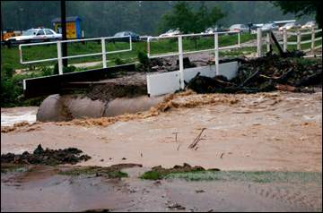
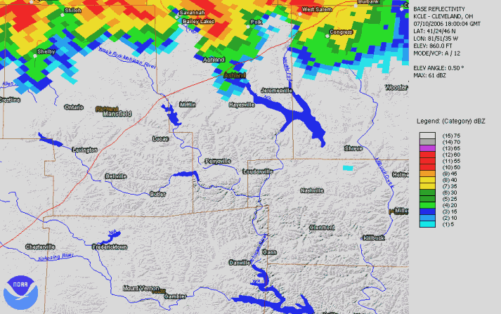
Heavy thunderstorm rains fell on the northeastern corner of Knox County, Western Holmes County, Southern Ashland County, and Southern Richland County during the afternoon and early evening hours of July 10th. A spotter near the intersection of State Route 3 and College Hill Road in Knox County measured a storm total of 7.5 inches. Up to 7 inches of rain was reported in the Danville area with 5.5 inches of this total falling between 3 and 5 p.m. Other reports included: 7 inches east of Butler, 6.52 inches in Nashville, 3.96 inches in Stillwell, 3.41 inches at the Mohicanville Dam, 3.26 inches in Loudonville, 3.09 inches near Belleville, 2.89 inches at Pleasant Hill Dam and 2.10 inches in the City of Ashland. Runoff from the heavy rains caused the Mohican River to rise very quickly. A four foot wall of water reportedly moved down the river forcing several people in canoes to climb into trees. Firefighters later rescued eight people from the river or trees. The river continued to rise more than a foot per hour through the evening hours. Up to 700 campers had to be evacuated from Mohican State Park, many by boat. Several campgrounds on Wally Road south of Loudonville also had to be evacuated because of flooding. These evacuations continued through 10 p.m. and were hampered by several mudslides along Wally Road. Dozens of mobile homes and campers were damaged or destroyed. A woman had to be rescued from her home on Pleasant Hill Road. Extensive flooding also occurred along Pine Run south and west of Loudonville. A lot of flooding also occurred in and near Jelloway after Jelloway Creek went into flood. Four families had to be evacuated from homes along State Route 205 south of Jelloway. Other evacuations occurred along Howard-Danville Road southwest of Danville. Shadley Valley Creek also went into flood prompting several evacuations along Shadley Valley Road. Dozens of roads were flooded and many were washed out across the area. In addition, several bridges were damaged or destroyed. Street flooding was reported as far north as Mansfield and Ashland. |
|||||||||||||||||||||||
|
|
|||||||||||||||||||||||


