
|
Storms that require preparation DO occur in our area. Below is just a sampling of significant storms over the past decade across northern Ohio and northwest Pennsylvania that were life-threatening, caused prolonged power outages, evacuations, or destroyed homes. These storms span all seasons, reminding you of the importance of severe weather preparation year-round. Preparation begins with information including knowing the potential hazards for your area and knowing what to do before, during and after an emergency. Having a plan ahead of time and building a preparedness kit ready you for the most common disasters for your area. For more preparedness information visit: Ready.gov |
December 22-23, 2004: Heavy Snow, Freezing Rain, near Blizzard conditions

A record setting winter storm affected northern Ohio on December 22nd and 23rd of 2004. Low pressure moved from Texas to the Ohio Valley spreading heavy snow across the region. Nearly two feet or snow fell in some areas and new snowfall records were established at several locations. Gusts to 30 mph caused significant blowing and drifting and near blizzard conditions were reported in north central Ohio. Temperatures warmed slightly during the early morning hours of the 23rd causing the snow to change to freezing rain. Ice accumulations caused widespread power outages and tree damage along and south of the U.S. Highway 30 corridor. The combination of the freezing rain and the wet and very heavy snow made travel nearly impossible across northern Ohio. Hundreds of accidents were reported and holiday travel for many was not possible. It took several days for road crews to completely clean up after this event. Damage and cleanup costs for this storm were historic with only the Blizzard of 1978 having more financial impact.
January 5-6, 2005: Freezing Rain
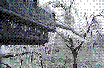

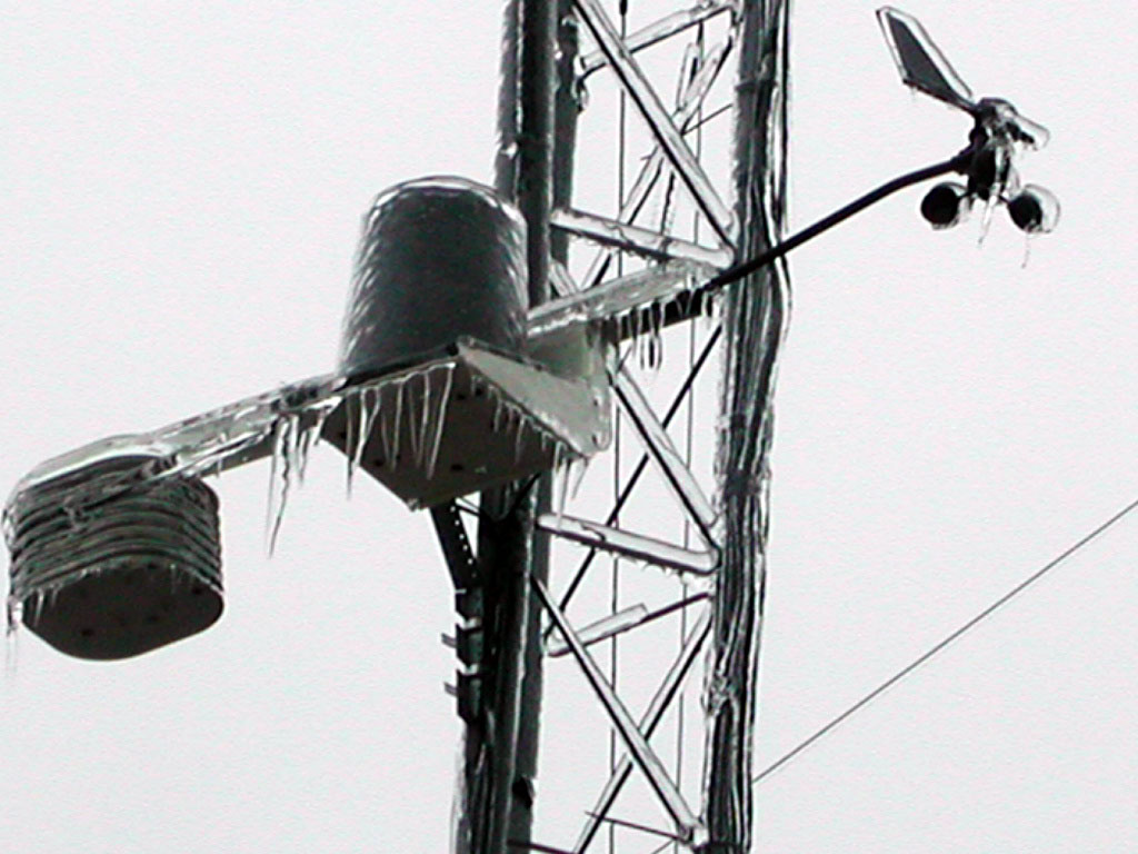
For the second time in just over two weeks, a devastating and historic winter storm affected Northern Ohio on January 5th and 6th. Significant ice accumulations occurred over most of the area downing thousands of trees, causing widespread power outages and making travel nearly impossible. The hardest hit locations were west of Interstate 71 along the U.S. Route 30 corridor. Ice accumulations of greater than three quarters of an inch were reported from the Findlay eastward to the Mansfield area. In cities like Mansfield, Bucyrus and Findlay, nearly every property in some neighborhoods sustained tree damage. Ice build up at the Davis-Besse Nuclear Power Plant (Ottawa County) damaged the facility enough to force it to be temporarily shut down. Hundreds of crews were brought in from around the county to help restore the power outages. In addition to damage caused by fallen trees and limbs, a lot of basement flooding occurred as power outages prevented sump pumps from working. Clean up and repair costs for this storm were among the highest ever recorded for a natural disaster in Ohio. In Richland County alone, cleanup cost accrued by local governments totaled nearly $6 million.
July 28, 2006: Flash Flooding

Historic flooding occurred in Lake County after days of heavy rainfall. After a brief lull, heavy thunderstorm rains resumed just after midnight on the 28th and a devastating flash flood quickly developed. By daybreak on the 28th, as much of 10 inches of rain had fallen on portions of Lake County. In Painesville, the Grand River rose from a stage of 2 feet on the morning of the 27th to 17.36 feet around 5 a.m. on the 28th establishing a new record stage. Damage along the river was catastrophic and homes along Main Street, Millstone Drive, Gristmill Drive, Steele Avenue and Grand River Avenue were devastated. Approximately 25 people had to be rescued by boat from rooftops after flood waters climbed into the second floors of their homes. Several other people had to be rescued by helicopter because the flood waters were flowing too fast to allow boat rescues. Around 3,600 families in Lake County applied for flood assistance. Damage in Lake County during this event was unprecedented. The flooding has been classified as a 500 year event.
February 14, 2007: Heavy Snow
 Low pressure moved from the Great Plains to the Ohio Valley on February 13th and 14th. Moisture from the Gulf of America combined with arctic air to cause heavy snow over the Upper Ohio Valley. Between 12 and 18 inches of wet and very heavy snow fell across the local area. Cleveland had its third snowiest 24 hour period ever with 15.8 inches of snowfall. A peak total of 23.5 inches was measured at nearby Pepper Pike. Winds gusted to as much as 40 mph during this event causing extensive blowing and drifting. Hundreds of schools were closed and travel was nearly impossible at times.
September 14, 2008: Remnants of Hurricane Ike
The remnants of Hurricane Ike moved from southeast Missouri at daybreak on September 14th to Northwest Ohio by late afternoon. Damaging winds of greater than 60 mph accompanied this storm system and caused widespread damage across northern Ohio and northwestern Pennsylvania. Damage and cleanup costs from this event approached $500 million in northern Ohio alone. Reports of high winds and wind damage began during the middle part of the afternoon and tapered off late in the evening. The damage across the area was extensive with thousands of trees, power lines and utility poles downed. The time of year of this event contributed greatly to the amount of damage that occurred since the trees in the area were still foliated. Utility crews from Pennsylvania, New Jersey, New Hampshire, Connecticut and Massachusetts were dispatched to the region to help the restoration efforts. Hundreds of vehicles were damaged by fallen trees or limbs. Crop losses from the high winds were also significant.
January 15-17, 2009: Cold Outbreak

A strong area of arctic high pressure moved from the Northern Plains on January 15th to the Upper Ohio Valley by late in the day on January 16th. The high eventually shifted east of the area on the 17th. Very cold temperatures accompanied this high. The coldest temperatures since January 1994 were recorded at most observing sites. Gusty southwest to west winds made it feel even colder with wind chills colder than minus 25 reported from the evening of the 15th through the afternoon hours of the 16th. Winds eventually lessened early on the 17th which allowed temperatures to again plummet to 10 below or colder for the third morning in a row at many locations. Cooperative observers in Knox County reported lows of -28 and -29 on the 17th. Most of the schools in northern Ohio and northwestern Pennsylvania were closed on both the 15th and 16th.
June 5-6, 2010: EF4 Tornado

A devastating tornado moved across portions of northern Wood County and western Ottawa County during the late evening hours of June 5th. The tornado reached a peak intensity of EF4 and was responsible for the deaths of seven people. The initial touchdown occurred east of Perrysburg near the Ohio Turnpike. The tornado then moved east northeast for around 9 miles before lifting near Clay Center. The tornado moved across the edge of Toledo Executive Airport and destroyed a Lake Township administrative building and a high school. Several of the fatalities occurred in this area. The tornado then crossed Interstate 280 and reached EF4 intensity as it approached Main Street on the north side of Millbury. The tornado then moved into Ottawa County causing more damage. This tornado destroyed or heavily damaged nearly 100 homes. Dozens of additional homes sustained minor damage with another couple hundred homes were affected by the storm. Dozens of vehicles were also destroyed including seven Lake Township police vehicles and eight school buses. Hundreds of trees were toppled or snapped by the tornado along the damage path which was up to 400 yards in width. The tornado debarked some of the larger trees along the damage path. At least one high tension utility pole was toppled by the tornado and widespread power outages occurred in Millbury and Walbridge. The exact number of injuries caused by this tornado is unknown, but at least 17 people had to be hospitalized in nearby Toledo. Debris from this tornado has been found dozens of miles away, including on some of the islands in western Lake Erie. Five other tornadoes were reported on the 5th and 6th. There was one fatality in Erie County, Pennsylvania.


February 1-2, 2011: Freezing Rain, Sleet, and Snow
Three waves of wintry precipitation affected the local area on February 1st and 2nd as low pressure moved up the Ohio Valley. The first wave of precipitation moved into the region early on the 1st and ended just after daybreak. A coating of ice was reported in most areas along with some light snow. The second wave of precipitation began during the late afternoon and evening hours. Most of this was also mixed freezing rain and sleet. Only the northwestern corner of the area saw predominantly snow. Ice accumulations of between one quarter and one half inch were reported along with an inch or more of sleet accumulation. This mixture coated area roads and streets and resulted in treacherous travel. A few power outages resulted from the freezing rain early on the 1st. Power outages were more numerous on 2nd. Trees and power lines already weighted down from ice from the first wave gave way with this second round of ice. Stark County was especially hard hit by power outages. Over 50,000 residents in the Canton area alone lost power. Wrap around snow behind the low affected northern Ohio during the daylight hours of the 2nd. Some of the snow was locally heavy with visibilities at times less than a quarter mile. Much of the area saw between one and three inches of snow. Strong winds also accompanied the precipitation with gusts as high as 40 mph during the morning hours of the 2nd. Over 500 schools were closed in northern Ohio and northwestern Pennsylvania on February 1st and 2nd. Many schools remained closed on February 3rd because of residual thick ice on parking lots, sidewalks and secondary roads. This ice resulted from the combination of two days of mixed freezing rain, sleet and snow and was up to two inches thick in some areas. Removing the ice from sidewalks and driveways was nearly impossible.
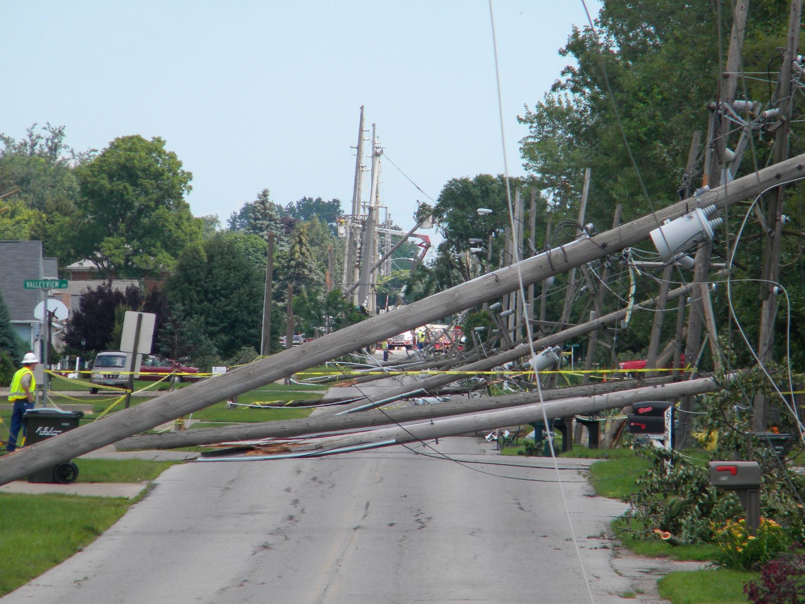
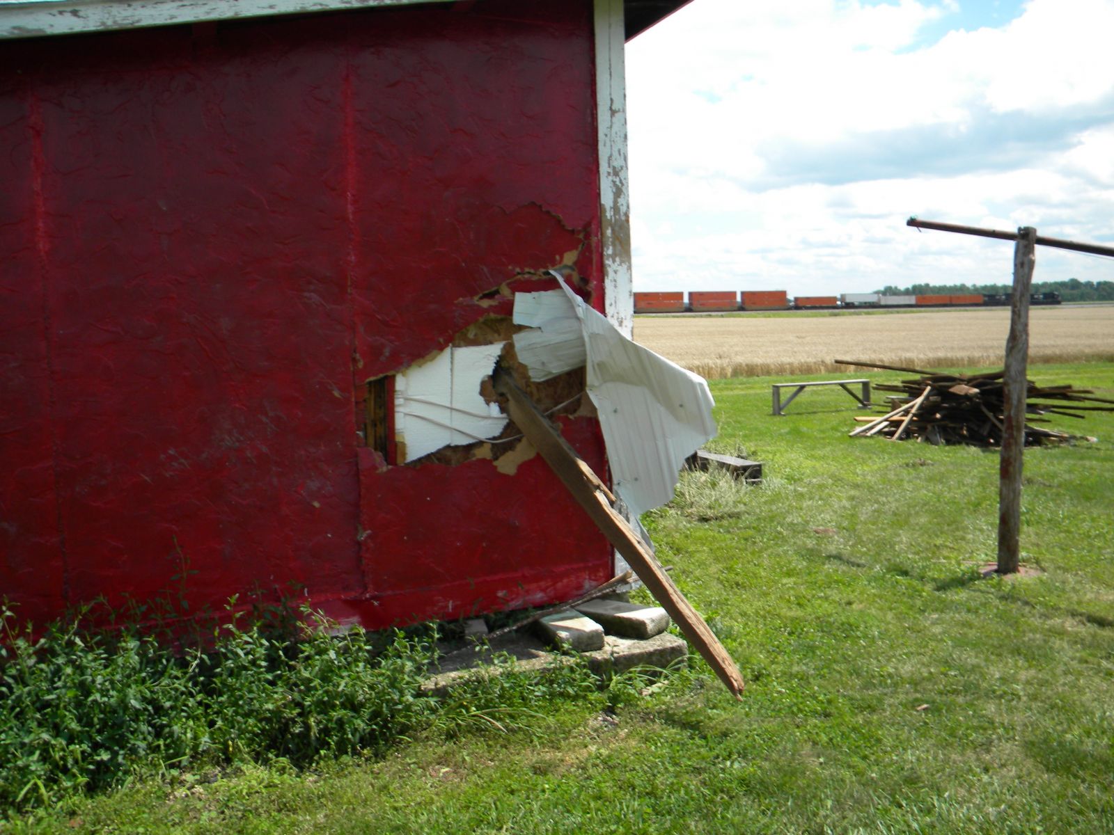
June 29, 2012: Derecho
A line of intense thunderstorms or Derecho developed over northern Indiana during the early afternoon hours of June 29th. This line of storms intensified as it moved across Central Ohio later in the afternoon. Extensive damage was reported in Hancock, Wyandot, Marion, Morrow and Knox Counties. Lesser amounts of damage were reported just to the north of these counties. The damage from this Derecho is comparable to the damage from the remnants of Hurricane Ike in 2008. Thousands of trees and hundreds of utility poles were downed by this line of storms. A 84 mph wind gust was measured in Findlay. Cleanup costs were significant from this storm. Cleanup efforts were hampered by an ongoing heat wave with afternoon temperatures as warm as 100 degrees. The damage was even more severe across Central Ohio were over a million people in the Columbus area lost power. This Derecho continued to the east coast causing major damage along the way.

October 29-30, 2012: Remnants of Hurricane Sandy
 Hurricane Sandy tracked up the east coast of the United States and merged with an upper level system on October 29, 2012. Sandy transitioned to a post-tropical cyclone and came onshore around 8 pm EDT in Southern New Jersey with an impressive central pressure of 946 mb. The remnants of Sandy then tracked west across Pennsylvania overnight on October 29 and brought damaging winds and prolonged rainfall to Northern Ohio. Northerly winds were especially strong downwind of Lake Erie with a peak gust to 68 mph reported at Cleveland Hopkins Airport. Winds gusted to more than 60 mph for several hours. The strong winds caused extensive tree damage with widespread power outages and caused structural damage to some buildings. Hundreds of homes lost roofing or siding or were damaged by fallen trees. Power outages associated with this storm exceeded 250,000 customers across Northern Ohio, with over 160,000 outages in Cuyahoga County alone. The Cleveland Metro area was particularly hard hit by this storm with many area schools closed for two days. Air traffic was stopped at Cleveland Hopkins International Airport from late on October 29 to approximately noon on October 30.
The strong northerly winds caused a two to three foot storm surge along the south shore of Lake Erie along with 15 to 20 foot waves. Water crashing over the break wall closed Interstate 90 on the east side of Cleveland for several hours. Area marinas sustained damage with reports of many personal watercraft submerged and additional boats drifting out into the lake. According to the Coast Guard, 118 vessels were either sunk or significantly damaged. Beach erosion was reported at numerous beaches and sand had to be cleared from the roadways along in Port Clinton.
July 10, 2013: Severe Thunderstorms and Flooding

A hot and humid airmass remained in place over the Ohio Valley on July 10th. This led to widespread severe weather and flooding and even a couple weak tornadoes. Strong thunderstorms dumped heavy rain on the local area during the predawn hours. Significant flooding occurred in the City of Mansfield where flood waters up to three feet deep inundated the north end of the city. Then, a line of intense thunderstorms developed ahead of an advancing cold front during the afternoon hours. Thunderstorm wind gusts in excess of 70 mph were reported. Seneca and Sandusky Counties in north central Ohio were especially hard hit. Thousands of downed trees and widespread power outages were reported. The Bellevue area was especially hard by the combination of straight line winds and a weak tornado. These storms also produced very heavy rainfall with rainfall rates of three inches per hour. This combined with ground already saturated led to the renewal of flooding. A swath of heavy rainfall from Wadsworth east into the Akron area led to devastating flooding. In Wadsworth, flooding from Holmes Brook and the River Styx overwhelmed portions of the city. Numerous people had to rescued from stranded homes and vehicles. The flooding in Akron was similar with numerous water rescues reported. Thousands of homes in the Upper Ohio Valley sustained damage from the flooding.

