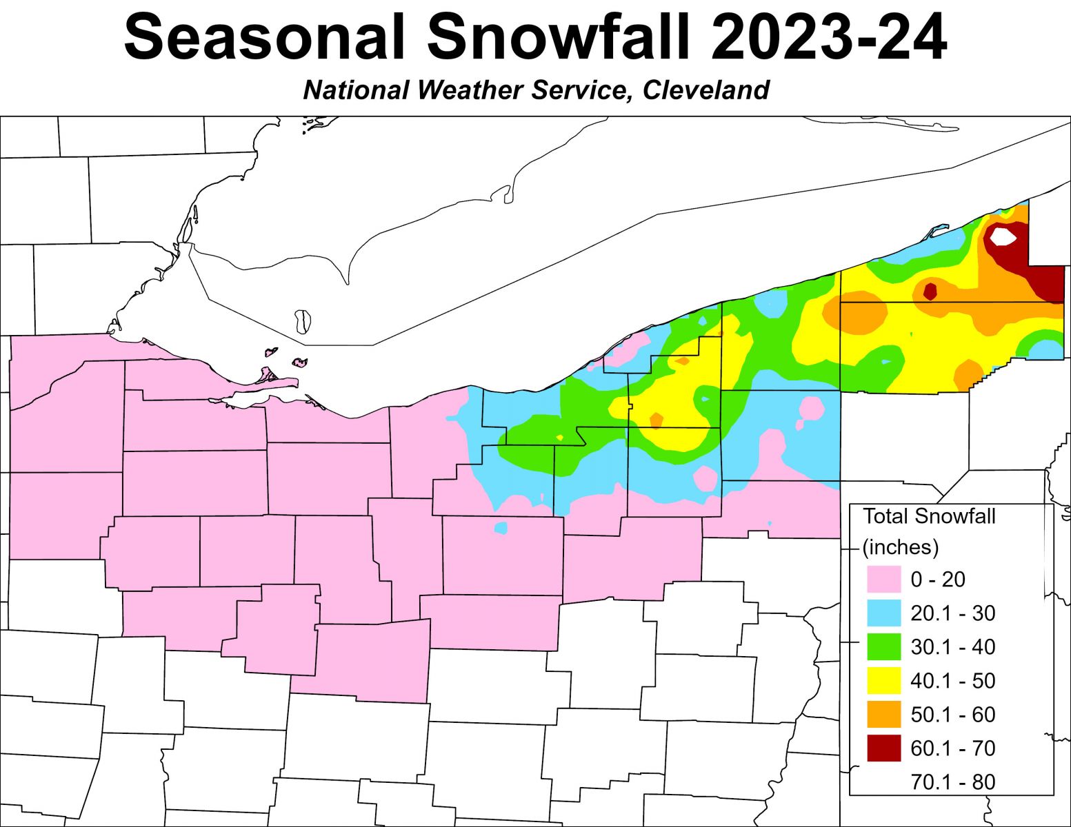
Winter 2023-2024 was the second in a row to feature very mild conditions, characterized by much below normal snowfall and much above normal temperatures. A strong El Nino was present in the eastern Pacific Ocean characterized by above normal sea surface temperatures near the equator, and this commonly brings warm and dry winters to the Ohio Valley and Great Lakes regions. Meteorological winter, defined as December, January, and February, had temperatures that averaged 4 to 7 degrees above normal across northern Ohio and Northwest Pennsylvania, and the warmth continued into the Spring months of March, April, and May when temperatures averaged 3 to 5 degrees above normal. This led to a very mild winter quickly transitioning to an early Spring. Snowfall departures were even more impressive and finished at least 30 to 40 inches below normal across northern Ohio and Northwest Pennsylvania, with snowfall of over 70 inches below normal in the snowbelt counties of Northeast Ohio and Northwest Pennsylvania. A few spotters in the snowbelt reported tallying their all-time lowest seasonal snowfall in 30 years of measuring!
Despite the very tame winter, there were some short periods of cold and snow. The winter started out promising for snow lovers with the first flakes occurring late on Halloween evening as the trick-or-treaters were finishing up. A sharp cold front crossed the region bringing a burst of lake enhanced snow late on October 31 as it interacted with the relatively warm waters of Lake Erie, and lake-effect snow showers continued off and on into November 1. This produced light accumulations in higher elevation areas, but 1 to 4 inches fell in parts of the primary snowbelt of Northeast Ohio and Northwest Pennsylvania. After a return to warmer weather the rest of the month, another lake-effect event produced locally heavy snowfall in both the primary and secondary snowbelts on November 28. A strong cold front crossed the region with westerly winds and arctic air in its wake setting up a heavy band of lake-effect snow from eastern Lake County through northern Ashtabula County into Erie County, Pennsylvania from the evening of November 27 into the pre-dawn hours of November 28. This band deposited 10-12 inches of snow in those areas before shifting southward through the Cleveland Metro area and secondary snowbelt south of Cleveland during the morning commute. This deposited a quick few inches during rush hour, with snowfall rates exceeding 2 to 3 inches per hour creating treacherous road conditions. The snow melted quickly as winter went back into hiding for most of December, so the early season bouts of snow did not mean an active winter at all. There was a notable event on December 18 when a low pressure system interacted with cold air to produce a widespread 3 to 7 inches of snow, with locally up to 8 inches. This snow largely fell over north central and Northeast Ohio into Northwest Pennsylvania and was upslope dependent, with little to no accumulations near the lakeshore. However, December was otherwise mild and snowless. The most concentrated period of cold and snow occurred in mid January when temperatures stayed below freezing from January 13 through 22 along with a couple of nights featuring single digit lows. The winter was largely confined to this 10 day period. This period of winter weather was ushered in by a strong low pressure system that crossed the region January 12-13 bringing strong winds followed by falling temperatures and rain changing to snow as the arctic cold front swept through the region. By January 14, single digit temperatures only reached the teens for highs as arctic air became entrenched across the Great Lakes. This set up lake-effect snow showers and squalls that brought occasional light to moderate snows to Lake and Ashtabula Counties, as well as Erie County, Pennsylvania, throughout the week. A frequent southwesterly component to the wind kept the bulk of the lake-effect snow over the Buffalo area of western New York, so much of northern Ohio and Northwest Pennsylvania was just cold and dry for the week. Widespread snow finally occurred at the end of this cold snap January 19-20 as low pressure interacted with the arctic air, with most areas seeing 3 to 6 inches. Northerly flow across Lake Erie combined with upsloping enhanced this snowfall, and that led to heavier amounts of 8 to 12 inches in the secondary snowbelt between Cleveland and Akron, as well as parts of Northwest Pennsylvania where 12 to 18 inches fell. Unfortunately, the arctic air retreated within 2 days of this storm, and the mild pattern returned and lasted through February. This led to a quiet February, with the only significant, widespread snowfall occurring February 16-17 during President’s Day weekend. Low pressure passed through the lower Ohio Valley on the evening of February 16, bringing light snow to most of northern Ohio. Amounts only averaged a few tenths to up to 3 inches, but it impacted the Friday evening rush hour leading to dozens of accidents. A localized heavier band put down 5-10 inches in parts of Knox County despite light snow elsewhere. The snow transitioned to lake-effect overnight into February 17, with generally 1 to 4 inches falling in the primary snowbelt east of Cleveland and in northwest PA. Occasional light snow fell in March, but winter was essentially over, and not much more than a trace fell in April as all of the attention turned to the Great American Eclipse of 2024.
Summary of Snowfall at Climate Sites
(Preliminary until Certified by NCEI)
| 2023-2024 | October '23 | November '23 | December '23 | January '24 | February '24 | March '24 | April '24 | May '24 | Totals |
| Toledo (TOL) | 0.7" | 0.2" | T | 8.1" | 0.5" | 0.1" | 0" | 0" | 9.6 |
| Mansfield (MFD) | 0.3" | T | 0.7" | 5.0" | 2.0" | 0.4" | T | 0" | 8.4" |
| Cleveland (CLE) | 1.5" | 3.1" | 2.2" | 9.7" | 3.5" | 5.7" | T | 0" | 25.7" |
| Akron-Canton (CAK) | 0.3" | 0.3" | 2.3" | 7.8" | 2.8" | 1.5" | T | T | 15" |
| Youngstown (YNG) | 0.1" | 1.7" | 4.2" | 15.7" | 2.7" | 5.1" | T | T | 29.5" |
| Erie, PA (ERI) | 2.3" | 3.1" | 1.4" | 14.7" | 0.8" | 2.5" | T | 0" | 24.8" |

