The 2021-2022 winter season started out slowly with just some minor lake effect snow events in November and a mild December. The first cold air mass hit the region in mid-to-late November and produced lake-effect snow in the typical areas of Northeast Ohio and Northwest Pennsylvania. The first measurable snow occurred on November 13 and 14, followed by additional snow on November 18 and 19, which allowed for the first few inches of snow of the season for the Lake Erie Snow Belt. A widespread snow event occurred on the Saturday after Thanksgiving, when a low pressure system put down 1 to 3 inches of snow during the evening hours, making holiday weekend travel briefly difficult. December was then a mild month with very little snow. Temperatures through the month averaged in the lower 40s, or about 6-7 degrees above normal, and were within the Top 5 warmest Decembers since climate records were tracked in our area climate sites. Snow was sparse across the region with most locations receiving less than an inch and a half of snow. Only Snow Belt locations within Northwest Pennsylvania had multiple inches of snow with some paltry lake effect.
The quiet and mild weather continued for the first few days of 2022 before several cold air outbreaks entered the region and allowed for snow to return. The big event for the month was a major winter storm that moved up the Appalachians on January 16-17, bringing a widespread heavy snowfall for the Martin Luther King Junior holiday. Much of Northeast Ohio and Northwest Pennsylvania measured over a foot of snow from this storm but lake enhancement from Lake Erie allowed for additional snow to continue on Monday afternoon, and some snow belt locations received over two feet of snow before the event concluded. Intense snowfall rates of 1 to 2 inches per hour occurred early Monday morning, which hampered early cleanup efforts with this storm and most roads were impassable on Monday morning. For the following weekend, a potent Alberta Clipper system deposited 3 to 8 inches of snow over much of the area, adding to the area snowpack. In the end, January was a colder than normal month as temperatures averaged 4.5 to 5.5 degrees below normal.
Cold air and active weather continued into February with another winter storm on February 2-4. This winter storm featured heavy snow for much of the area, but precipitation changed over to sleet and freezing rain from a Mount Vernon to Youngstown line for several hours on February 3. Snowfall from this storm averaged 8 to 12 inches across the region, with every county in the NWS Cleveland county warning area being impacted. This storm was significant for Northwest Ohio with snow totals around one foot in the Toledo area and several Level 3 snow emergencies issued. After a brief break in the snow, there was a strong low pressure system that brought warm temperatures to the region on February 16-17, thawing out the persistent snow pack across the area. Heavy rain on the 17th allowed for some ice jams to form and rain combined with melting snow pack allowed for moderate to major flooding on several area rivers. However, on the night of the 17th, temperatures cooled significantly and rain changed over to ice and snow with a good coating of mixed precipitation in Northeast Ohio and Northwest Pennsylvania. Temperatures trended warmer for the end of February and melted off much of the remaining snow pack across the region. Cleveland ended a streak of 35 days with at least a trace of snow depth at 7 AM that spanned January and February.
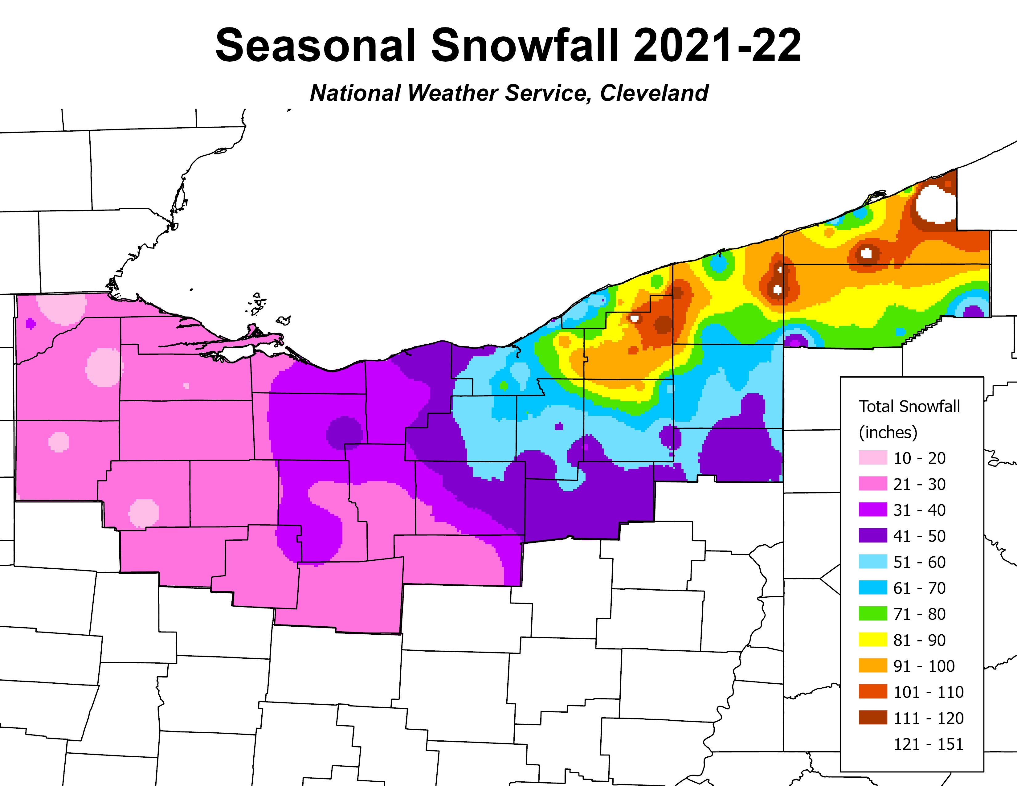
Winter ended on a quiet note in March as the month featured highly variable temperatures and a general lack of snow. Similar to the past couple seasons, winter tried to make a final push in April with a couple minor snow events. The most notable event occurred on April 1, as a snow squall impacted the Mid-Ohio region, including portions of Interstate 71 in Richland, Ashland, and Morrow counties. Over the span of 3 minutes, Interstate 71 became shrouded in snow with visibility under one-eighth of a mile and the road was covered in the matter of three minutes! This event allowed for NWS Cleveland to issue our first ever Snow Squall Warning. In the end, the winter season was slightly below normal for most locations, averaging about 10 inches of snow below normal across the board. A snow spotter in Greenfield Township, PA measured 151” of snow for the maximum within our area. A CoCoRaHS observer located northwest of Bowling Green, OH measured 11.9” of snow for the minimum within our area.
Summary of Snowfall at Climate Sites
(Preliminary until Certified by NCEI)
| 2021-2022 | October '21 | November '21 | December '21 | January '22 | February '22 | March '22 | April '22 | May '22 | Totals |
| Toledo (TOL) | 0 | 3.8 | 0.7 | 6.5 | 19.1 | 0.5 | 0.2 | 0 | 30.8 |
| Mansfield (MFD) | 0 | 3.5 | T | 8.3 | 13.1 | 0.6 | 1.1 | 0 | 26.6 |
| Cleveland (CLE) | 0 | 4.4 | 0.2 | 24.3 | 18.9 | 2.5 | 2.7 | 0 | 53.0 |
| Akron-Canton (CAK) | 0 | 5.8 | 0.4 | 25.7 | 12.1 | 6.7 | 1.3 | T | 52.0 |
| Youngstown (YNG) | 0 | 9.0 | 2.1 | 23.1 | 15.8 | 8.3 | 2.5 | 0 | 60.8 |
| Erie, PA (ERI) | 0 | 5.0 | 2.1 | 34.2 | 13.9 | 6.2 | T | 0 | 61.4 |

