
Equipment
The National Weather Service uses a variety of equipment, insturments, software and hardware to monitor and predict the weather.
Doppler Radar
National Weather Service Doppler Radar (also called the WSR-88D, which stands for  Weather Surveillance Radar - 1988 Doppler (the prototype radar was built in 1988) or NEXRAD (for Next Generation Radar )) is perhaps the most vital component in our weather watch. The 88D uses a variety of scanning sequences to examine precipitation and displays the radar data as two and three dimensional images. Reflectivity and velocity are the most common images. Reflectivity is a function of drop size and density and essentially shows the intensity of the precipitation. Velocity is the speed of the precipitation as it moves toward or away from the radar. Precipitation going in different directions in close proximity can be an indication of rotation. You can see the Doppler Radar from Interstate 480 or Brookpark Road as you drive by Cleveland Hopkins International Airport. Look near the NASA hanger on the west side of the Airport. Real time radar images are available on the blue menu bar on the front page of our web page. Weather Surveillance Radar - 1988 Doppler (the prototype radar was built in 1988) or NEXRAD (for Next Generation Radar )) is perhaps the most vital component in our weather watch. The 88D uses a variety of scanning sequences to examine precipitation and displays the radar data as two and three dimensional images. Reflectivity and velocity are the most common images. Reflectivity is a function of drop size and density and essentially shows the intensity of the precipitation. Velocity is the speed of the precipitation as it moves toward or away from the radar. Precipitation going in different directions in close proximity can be an indication of rotation. You can see the Doppler Radar from Interstate 480 or Brookpark Road as you drive by Cleveland Hopkins International Airport. Look near the NASA hanger on the west side of the Airport. Real time radar images are available on the blue menu bar on the front page of our web page.
Automated Surface Observing System (ASOS)
Weather observations at the ground are obviously essential. We need to know the 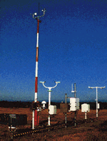 temperature, wind, amount of rain/snow etc. Certain observations are also essential for airport operations such as visibility and the height of the clouds. The National Weather Service, Federal Aviation Administration, and the Department of Defense developed and utilyze a system of instruments to measure these various weather parameters. It is called the Automated Surface Observing Sysytem (ASOS). ASOS systems are almost always located at airports and report the weather conditions at least once an hour. ASOS observations, in addition to other ground level reports, are used to make the surface weather maps the meteorologists use here at the weather office. temperature, wind, amount of rain/snow etc. Certain observations are also essential for airport operations such as visibility and the height of the clouds. The National Weather Service, Federal Aviation Administration, and the Department of Defense developed and utilyze a system of instruments to measure these various weather parameters. It is called the Automated Surface Observing Sysytem (ASOS). ASOS systems are almost always located at airports and report the weather conditions at least once an hour. ASOS observations, in addition to other ground level reports, are used to make the surface weather maps the meteorologists use here at the weather office.
Advanced Weather Interactive Processing System (AWIPS)
AWIPS is the computer workstation we use to display and analyze weather information. It can run a variety of software including Warngen, the software we use to issue warnings, and the Graphical Forecast Editor (GFE), the software we use to create the forecast. The system can display all forms of weather information (surface observations, 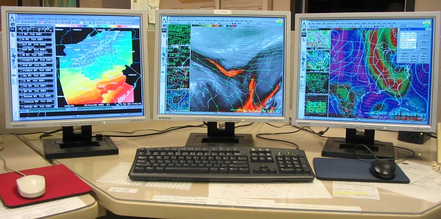 upper air data, radar, satellite, hydrology, model guidance, etc) simultaineously on a time and geography-synched display. Most AWIPS workstations consist of 4 terminals, three of which primarily display graphics (pictured) and one terminal primarily for text. Data comes into the system via a satellite downlink and products/data created locally at Cleveland are sent back out through a land line. upper air data, radar, satellite, hydrology, model guidance, etc) simultaineously on a time and geography-synched display. Most AWIPS workstations consist of 4 terminals, three of which primarily display graphics (pictured) and one terminal primarily for text. Data comes into the system via a satellite downlink and products/data created locally at Cleveland are sent back out through a land line.
NOAA Weather Radio (NWR) All Hazards 
How would you like to be alerted every time there is hazardous weather in your area? You can be with NOAA Weather Radio All-Hazards. NOAA Weather Radio is your 24-hour weather alert and hazard information source. We broadcast commercial-free National Weather Service weather information 24 hours a day on special FM frequencies. You have to have a radio 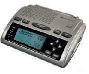 that is designed to pick-up the frequencies, so ask your local electronic retailer for a NOAA Weather Radio. The Weather Radio also acts as the National Weather Service's input to the Emergency Alert System. The Weather Radio uses specific area message encoding to trigger a digitial or audio alarm that you can get at home, warning you of dangerous weather. that is designed to pick-up the frequencies, so ask your local electronic retailer for a NOAA Weather Radio. The Weather Radio also acts as the National Weather Service's input to the Emergency Alert System. The Weather Radio uses specific area message encoding to trigger a digitial or audio alarm that you can get at home, warning you of dangerous weather.
|

