The Tidal Patterns of the South Carolina Lowcountry and Southeast Georgia
Neil Dixon - NWS Charleston, SC
|
|
The coast of the South Carolina Lowcountry and Southeast Georgia experiences a tidal change around every six hours, two low tides and two high tides a day. The difference in water levels between low and high tide can range between four to six feet on an average day. This frequent rise and fall of water along the coast has attracted people to the coast for thousands of years. Consider the late Archaic people at the Sewee Shell Ring, near Bulls Bay, around 4,000 BC. They depended on the tides for catching fish, crustaceans, oysters and clams. In fact, some experts theorize that the Sewee Shell Ring was constructed as a tidal water trap, designed to fill with water from high tide and then sealed with a wooden dam. The trapping of the water would allow the community members to easily catch any sea life that washed into the “C” shaped constructed shell mounds. |
|
|
Today, high tides still impact the lives of the people who live or travel near tidal zones/areas. The frequency of coastal flooding has increased in recent years. In the Charleston area, there were less than 10 coastal flood events per year in the 1980s, increasing to over 40 events per year in the 2010s, and currently averaging 57 events a year since 2020 (visit our Coastal Flooding Database: https://www.weather.gov/chs/coastalflood). Although the mechanics of coastal flooding are very complex, there are a few patterns to recognize when coastal flooding may occur. After all, tides are one of nature’s most reliable phenomena. |
|
Periods of high astronomical high tides or spring tides, commonly known as King Tides, occur during a full moon or new moon. Spring tides can flood area roads and property with salt water, making roads impassable for hours or even leading to flooding of homes and businesses. Coastal flooding is a combination of astronomical forces, wind direction and speed, atmospheric pressure, and other hydrologic and weather conditions. For example, on a given day, the astronomical tide is predicted to peak a foot below flood stage, the combination of strong northeast winds, passage of low pressure, and recent heavy rainfall creates a tidal departure (difference of the actual water level from the astronomical tide level) of a foot, resulting in the total water level to reach flood stage. The forecasters at the National Weather Service Charleston, SC consider this combination of factors to produce a “Total Water” forecast. The Total Water forecast applies to tidal water levels at two points; Charleston Harbor, SC and Fort Pulaski, GA. |
|
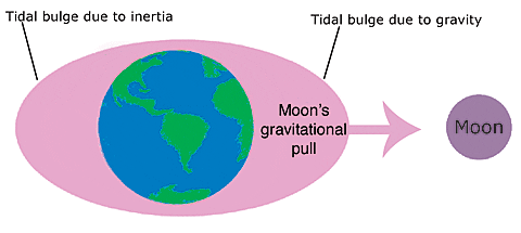
Considering only astronomical forces, tides are created by the gravitational pull of the sun and moon; water levels rise and fall according to the position of the sun and moon as the earth rotates on its axis, the moon orbits the earth, and the earth orbits the sun. The gravitational attraction between the earth and the moon is strongest on the side of the earth that happens to be facing the moon, simply because it is closer. The gravitational force exceeds inertia - caused by the rotating earth - and the water is pulled toward the moon, causing a “bulge” of water on the near side toward the moon and on the opposite side of the earth (image) (Ross, D.A., 1995). Unlike a 24-hour solar day, a lunar day (also known as a "tidal day") lasts 24 hours and 50 minutes. This occurs because the moon revolves around the earth in the same direction that the earth is rotating on its axis. The difference between the solar and lunar days explains why the arrival times of tidal bulges (high tides) and troughs (low tides) are around 50 minutes later each successive day. |
|
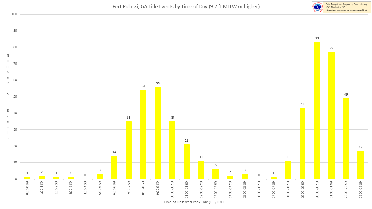
The semidiurnal tides along the South Carolina and Georgia coast will undergo changes as the earth orbits the sun during the course of a year. During the fall and winter, between October to early March, the higher of the two high astronomical tides will occur during the morning. During the spring and summer, between April to early September, the higher of the two astronomical high tides will occur in the late afternoon and evening hours. There are two periods of the year, the weeks around the spring equinox (March) and the fall equinox (September), where the two daily astronomical high tides are nearly equal. It is around the time of the spring equinox that the tides will transition from a morning dominant high tide to an evening dominant tide, the opposite will occur around the fall equinox. The changes in the dominant high tide times during the year occurs due to the earth’s axial tilt of 23.5 degrees, the gravitational force of the sun will change as the earth orbits the sun. The moon’s gravitational pull and associated tidal bulge will align closer with the sun’s during the morning during the cool season and will switch to the evening during the warm season. This chart of times of peak tide at the Charleston Harbor and Fort Pulaski, GA clearly shows that two peak times for coastal flooding, the morning peak occurs between 8-8:59 AM and the evening peak between 8-8:59 PM. Coastal flooding very rarely occurs between the two distribution peaks; these lulls occur between midnight-4:59 AM and 2-4:59 PM. In general, peak astronomical tides occur within a couple of hours of sunrise in the cool season and within a couple of hours of sunset in the warm season. |

|
Overall, the winter season is the least active period for coastal flooding for both the Charleston Harbor and Fort Pulaski, GA sites. During the period of record, December is the most active winter month for coastal flooding. In fact, the total number of observed moderate to major coastal flooding events in December is greater than January and February combined. Although coastal flooding is less frequent during this period, tide levels have reached major flood stage (8.0 ft. MLLW) in the Charleston Harbor during each winter month. Most of the year, the difference between the morning and evening astronomical high tides is a little more than half a foot. However, during the spring tide closest to the winter solstice the difference between the two high tides typically increases to 1.5 ft. The flooding tides during winter can be quite impactful to transportation as the flooding occurs during the morning rush hour. |
|
Spring is typically more active for coastal flooding than during the winter months. Most flooding events occur during the month of May for both the Charleston Harbor and Fort Pulaski, GA sites. In fact, the total number of events during the month of May is greater than March and April combined. The vast majority of spring coastal flooding ranges in the minor flood stage or nuisance flooding. In fact, March is the month with the least number of moderate flooding events and April is the next least active month for moderate flooding at both sites. Major coastal flooding rarely occurs during the spring, with only one event at the Charleston Harbor and no events at Fort Pulaski during the period of record. The low occurrence of moderate and major coastal flooding in the spring is likely contributed to two reasons; 1. Astronomical tides rarely peak within a half a foot of minor flooding, highest values usually in late April and May. 2. The spring season falls between the most common months for Nor’ easters (September into March) and the Atlantic hurricane season (June through November). Spring is an interesting time of the year as coastal flooding can occur during the morning in early March, transitioning to two equivalent high tides a day in the weeks around the spring equinox in mid to late March, then occurring after sunset in April and May. |
|
Summer is the second most active season for coastal flooding for both the Charleston Harbor and Fort Pulaski, GA sites. June typically has more coastal flooding events than July and August at both sites. However, the occurrence of moderate to major coastal flooding is nearly the same for June, July, and August. Peak high tides occur during the evening hours. Most of the year, the difference between the morning and evening astronomical high tides is a little more than half a foot. However, during the spring tide closest to the summer solstice the difference between the two high tides typically widens to 1.5 ft. |
|
Fall is the most active season for coastal flooding for both the Charleston Harbor and Fort Pulaski, GA sites. In fact, during the period of record, fall has far more flooding events than winter and spring combined. September and October are the most active months of the entire year. In addition, the fall has the most occurrences of moderate to major flooding. Many of these events were a result of storm surges associated with tropical systems. However, during the fall, perigean spring tides lead to pure astronomical tides to peak around minor flood stage within the Charleston Harbor and near minor flood stage at Fort Pulaski, GA. Times of the peak tide will occur in the evening in early September, transitioning to two equivalent high tides a day in the weeks around the fall equinox in mid-September into early October, then occurring around sunrise late October and November. |
|
Since records started for both sites in 1935, coastal flooding is three times more likely in the Charleston Harbor compared to Fort Pulaski, GA. The most significant episodes of coastal flooding occur with storm surges from tropical cyclones and other coastal storms. However, the vast majority of coastal flooding occurs at times of spring tides with onshore winds, especially with strong northeast winds. Below is a list of dates of the peak tides for South Carolina Lowcountry and southeast Georgia for 2023. People near coastal waterways should be on watch for coastal flooding during the dates of peak tides, especially when the weather is active. Here are a few general guidelines about the tidal patterns of the South Carolina Lowcountry and southeast Georgia:
|
Note: Dates in bold indicate the highest annual astronomical "King" tide at both the Charleston Harbor and Fort Pulaski, GA.
April 26-29 (Evening)
May 25-28 (Evening)
June 24 (Evening)
September 10-11 (Both High Tides)
October 6-10 (Morning)
November 4-9 (Morning) *highest astronomical tides of the year
December 3-6 (Morning)
Ross, D.A. 1995. Introduction to Oceanography. New York, NY: HarperCollins. pp. 236-242.
National Ocean Service: Tide and Water Levels -https://oceanservice.noaa.gov/education/tutorial_tides/welcome.html
NASA’s Science Earth’s Moon - https://moon.nasa.gov/moon-in-motion/tides/
NOAA SciJinks - What Causes Tides?


 Coastal Flood
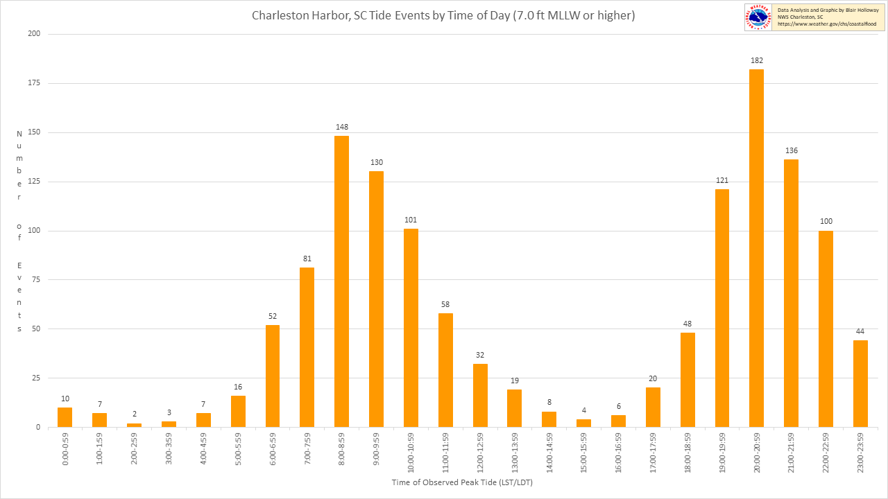