
Life-threatening, potentially catastrophic flash flooding expected along the central Gulf Coast as the remnants of Arthur track across the area. Isolated brief tornadoes and damaging gusts remain possible overnight in the Southeast. Isolated to scattered dry thunderstorms may cause lightning-ignited fires and erratic behavior due to gusty winds across parts of the West Friday. Read More >
by
Richard Thacker, Senior Forecaster
James Brotherton, Meteorologist Intern
This is a brief overview of the complex convective interactions that occurred during a severe weather outbreak in southern South Carolina on June 22nd, 2000. The study is centered on severe thunderstorms that affected Hampton and Colleton counties between 20Z and 22Z. These storms produced large hail, damaging winds, and one tornado in the city of Hampton.
At the surface, a weak low pressure area was located in the upper Great Lakes region and a mid-latitude cyclone with a central pressure of 988 mb, was located in central Quebec. Associated with the cyclone was a broad, slow moving cold front, located from New England through central Virginia, and trailing southwestward to the south gulf states. At 12Z on June 22nd, the cold front was slowly moving into extreme western South Carolina. Significant moisture was in place ahead of the cold front, with dew point temperatures in south coastal South Carolina and southeast Georgia around 24 degrees C.
Click here to see a surface chart at 12Z on June 22nd
At 850 mb, the flow at 12Z was parallel to the surface cold front. Dry air was being advected into the southern Appalachian area. In eastern Tennessee, western North Carolina and extreme western South Carolina, dew point temperatures were less than 10 degrees C. Further east, in sections of southern and coastal South Carolina, there was ample moisture in place, with dew point temperatures around 14 degrees C. A well defined theta-e ridge was elongated southwest to northeast over southeast Georgia and the coastal Carolinas.
At 500 mb, mid-level jet action was occurring in the Ohio Valley and New England areas, but flow was relatively weak (less than 30 knots) over most of the southeastern United States.
At 300 mb, short wave energy was propagating along the trough axis. An 80 knot jet streak was a supporting mechanism for the severe weather development. At 12Z on June 22nd, the jet streak was located from northwest South Carolina to west central North Carolina. The severe weather that subsequently developed across southern South Carolina was located near the right rear entrance region of this jet streak. Other large scale upper level dynamics were weak, such as temperature and vorticity advection.
Upper level forcing mechanisms, climatologically speaking, are rare by late June in the southeastern United States, as are synoptic-scale dynamics at any level throughout the atmosphere. This is because the jet stream is typically well north of the area, and the influence of the Bermuda high is a dominating force of the upper-level flow. However, on June 22nd, this was not the case.
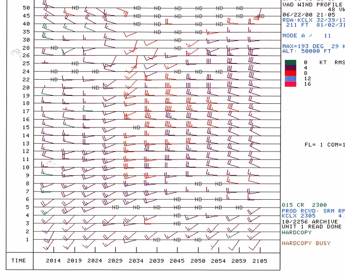
Click here for a vertical profile of the wind, from the CLX WSR-88D
Favorable surface / low-level moisture and synoptic features, as well as seasonably significant upper-level features, prompted the Storm Prediction Center to issue severe thunderstorm watches for a large portion of the Southeastern United States, including southern South Carolina, during the afternoon of June 22nd.
A series of complex mesoscale interactions occurred over Hampton County during this convective event. Numerous outflow boundary collisions and cell mergers were noted along a region of prime surface moisture convergence extending from Screven County Georgia northeast to Colleton County in southern South Carolina during the afternoon of June 22nd. There were several severe storms on this afternoon, but the most intense storm occurred in Hampton County. A brief F1 tornado touched down in the city of Hampton and numerous wind damage events took place in the county between 2030Z and 2100Z. The following is a brief summary to accompany the set of graphics depicting the events that unfolded just north of the KCLX RDA, located in northern Jasper County.
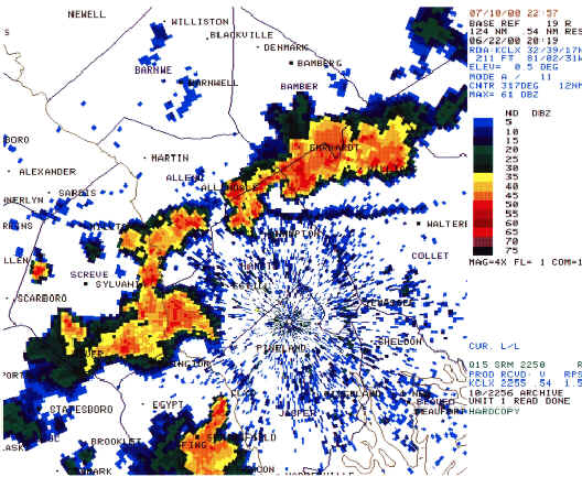
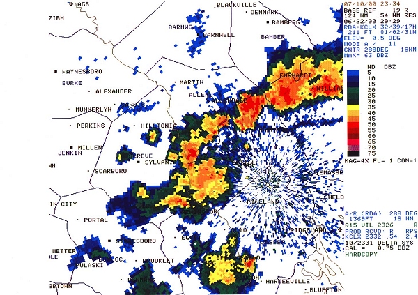
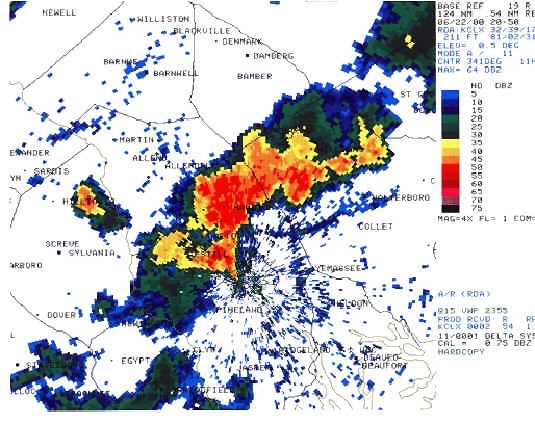
At 2019Z, a severe thunderstorm was anchored across northern Colleton County producing large hail near the town of Lodge. Another suspect cell (possibly a wind producer) was moving northeastward into extreme southwestern Hampton County. While the latter storm was entering a decaying stage, the northern Colleton cell appeared to be back-building along a southward moving outflow boundary. It was the combination of these two features that prompted a severe thunderstorm warning for Hampton County. The warning was based on the 2019Z volume scan and was issued at 2021Z.
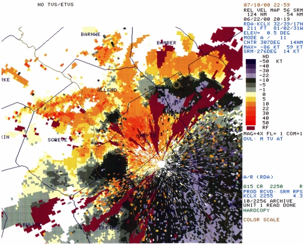
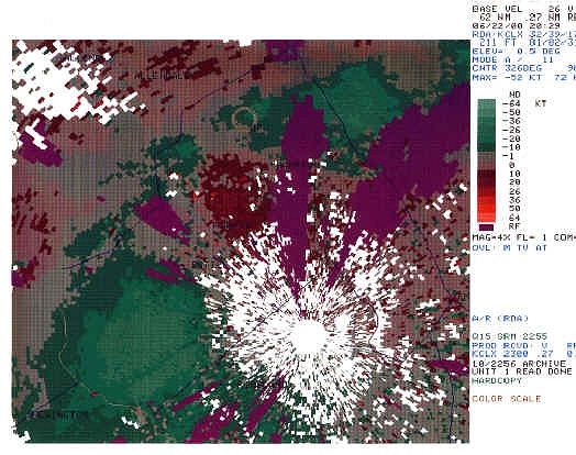
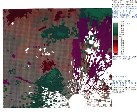
On the 2019Z SRM graphics, two distinct areas of convergence are evident. The stronger region was located along the Colleton and Hampton county line where the 1.5 degree SRM depicted around 60 knots of convergence. The second area, in the southwest corner of Hampton County, accounted for about 30 knots of convergence off of the 0.5 degree SRM.
Ten minutes later, the 2029Z base reflectivity graphic showed the cell in northern Hampton County was in a rapid growth stage, enhanced by an intense boundary collision from the Colleton County cell and the weakening convective cluster approaching from the southwest. The 0.5 base velocity graphic indicated impressive convergence in the cells northwest and north of the city of Hampton. An elevated mesocyclone was developing north of Hampton. The next scan at 2034Z continued to show strong convergence at the lowest elevations. At this point, a deep mesocyclone from 11 thousand feet to 25 thousand feet had developed, but subsequent scans did not reveal any significant low level rotation.
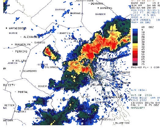
The 0.5 base reflectivity graphic at 2045Z clearly depicts a very complex mesoscale situation with a myriad of boundaries, two adjacent severe cells, and an impressive inflow notch in the vicinity of the city of Hampton. The mesocyclone algorithm showed shallow elevated rotation in the same general location as the inflow notch. The base velocity graphics were shadowed by range folding, but they did indicate a low level divergent signature to the northwest of Hampton.
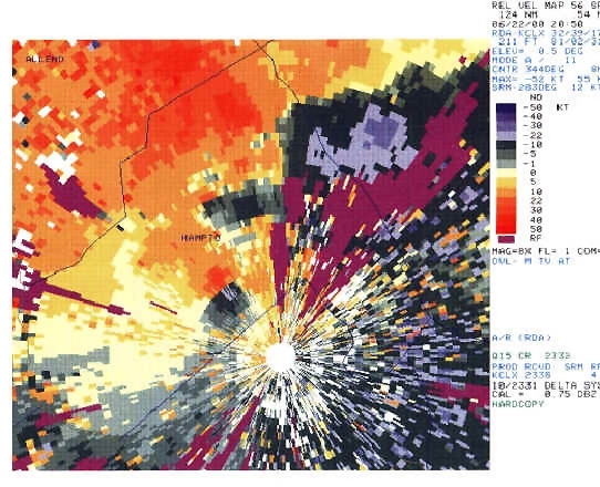
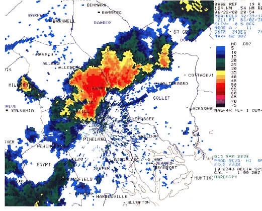
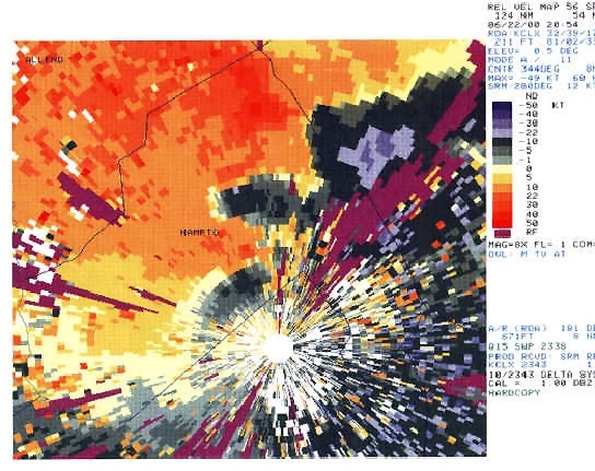
It appears the brunt of the wind damage occurred between the previous volume scan and the scan at 2054Z. On the 2050Z 0.5 base reflectivity slice, the southernmost cell over Nixville was producing significant straight-line wind damage as evidenced by the impressive divergent base velocity signature on the 0.5 base velocity product zoomed to 8X. That cell had a distinct question mark shape and was merging with the larger rotating cell over the city of Hampton. The Hampton cell was losing rotational characteristics at this time but still was producing several wet microbursts as also evidenced by the broader scale 0.5 base velocity product at 2050Z.
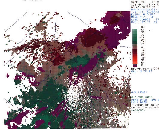
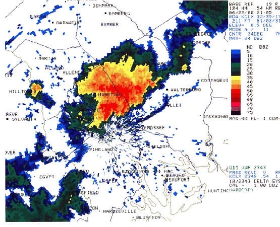
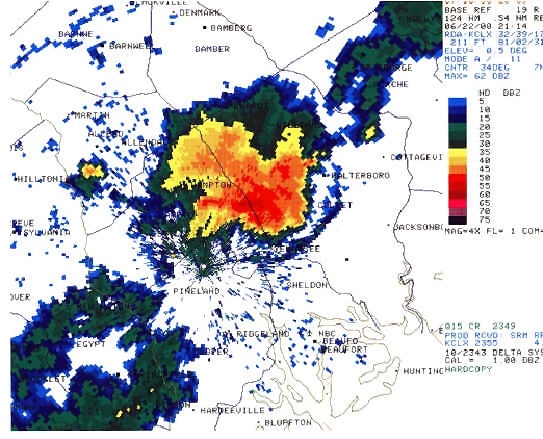
The next volume scan at 2054Z clearly showed that the two cells had merged. The merger was the first phase in a developing bow echo situation. On the 2054Z SRM, a couple of divergent signatures were still obvious, although with weaker velocities.
The final stage of this multi-phase convective complex was very interesting. At 2105Z, the 0.5 base reflectivity product showed that the cell that earlier crossed the Savannah River into southwestern Hampton County, had completely merged with the complex back-building convective cluster in Hampton and Colleton Counties. Between 2105Z and 2124Z, the convection formed an "arrow" signature and began to plow southeast through Colleton County into northern Beaufort County. The radar signature and new aggressive motion prompted another severe thunderstorm warning for Colleton County, and while there was a report of wind damage from a rural location, the overall trend of weakening continued and the cell dissipated before reaching the coast. It is unsure whether boundary collisions or the ambient mid level flow forced the cell to behave in this manner. It does appear that the complex became driven by a large outflow region originating from the Colleton convection which earlier produced the large hail near Lodge in the far northern part of the county.
The short time frame of events portray supercell, multicell, and pulse phases of convective development and dissipation on a very small scale. Differing types of cellular structure merged over Hampton County which led to a hybrid type bow echo signature near the end of the storm's life cycle.


 Coastal Flood
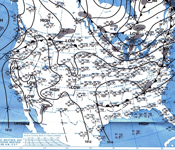