Click the tornado icon on the map to display the damage survey summary and on the tornado track for tornado details.

 |
 |
 |
 |
 |
| EF0 | EF1 | EF2 | EF3 | EF4 |
| EF0 Tornado near Brooklet, GA (Bulloch County) | |||||||
| Start Time | End Time | Max EF-Scale Rating | Max Wind Speed | Max Path Width | Path Length | Fatalities | Injuries |
|---|---|---|---|---|---|---|---|
| 7:08 PM EDT | 7:09 PM EDT | EF0 | 80 mph | 250 Yards | 0.19 miles | 0 | 0 |
|
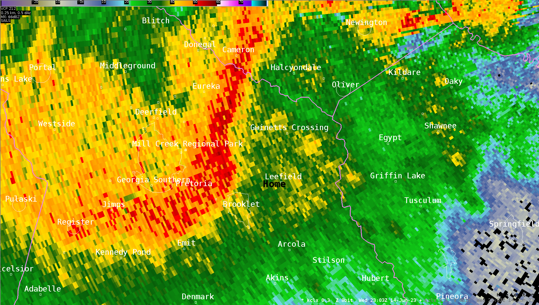
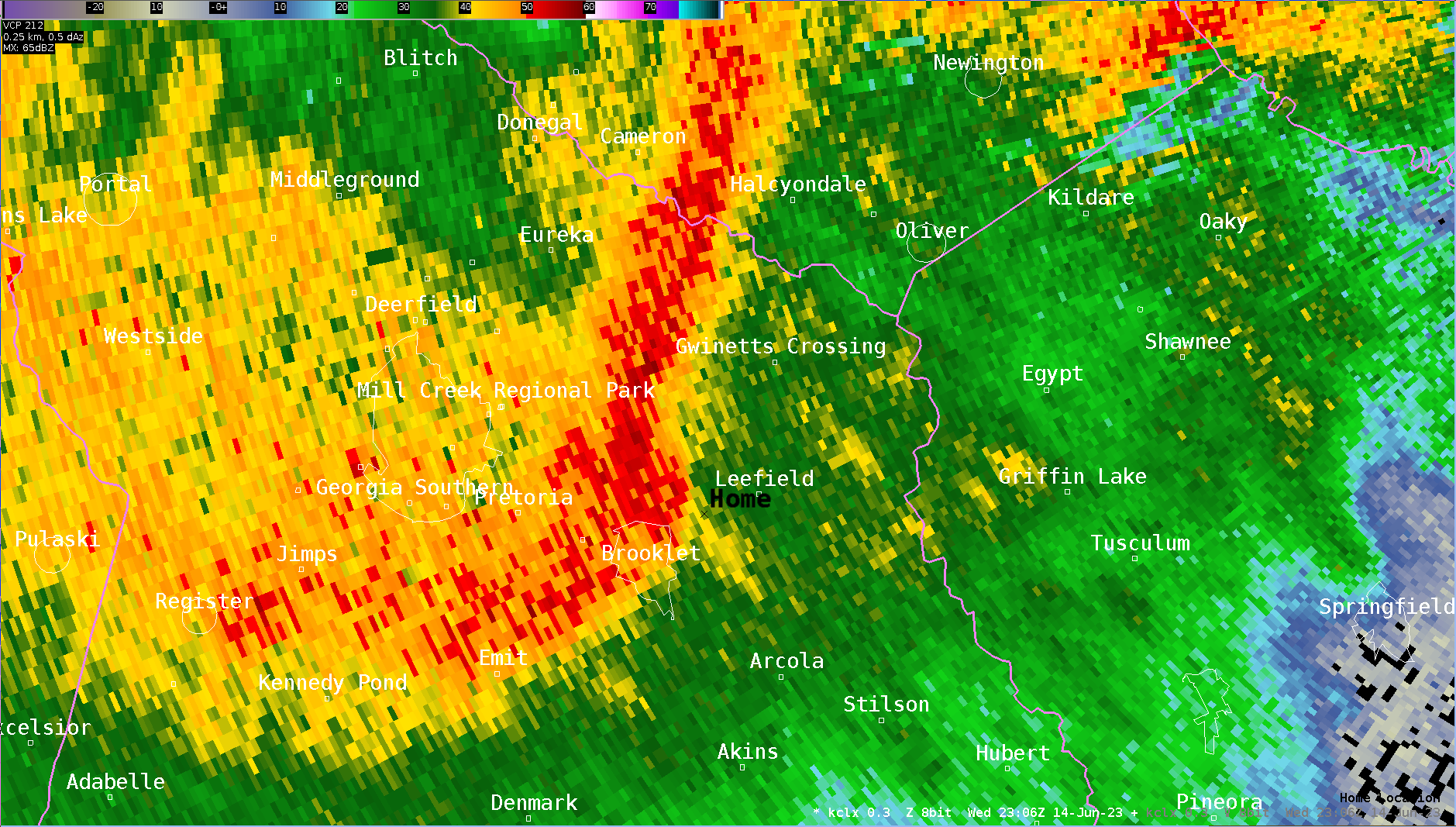
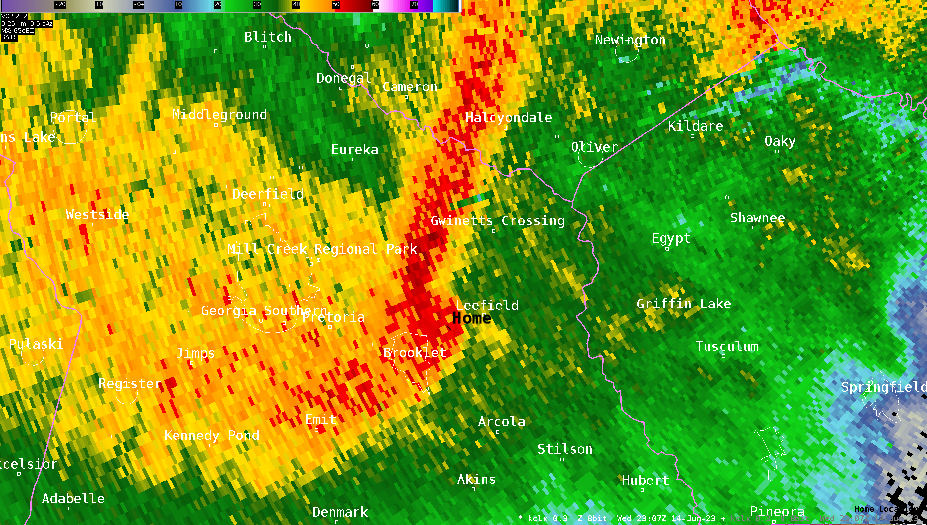
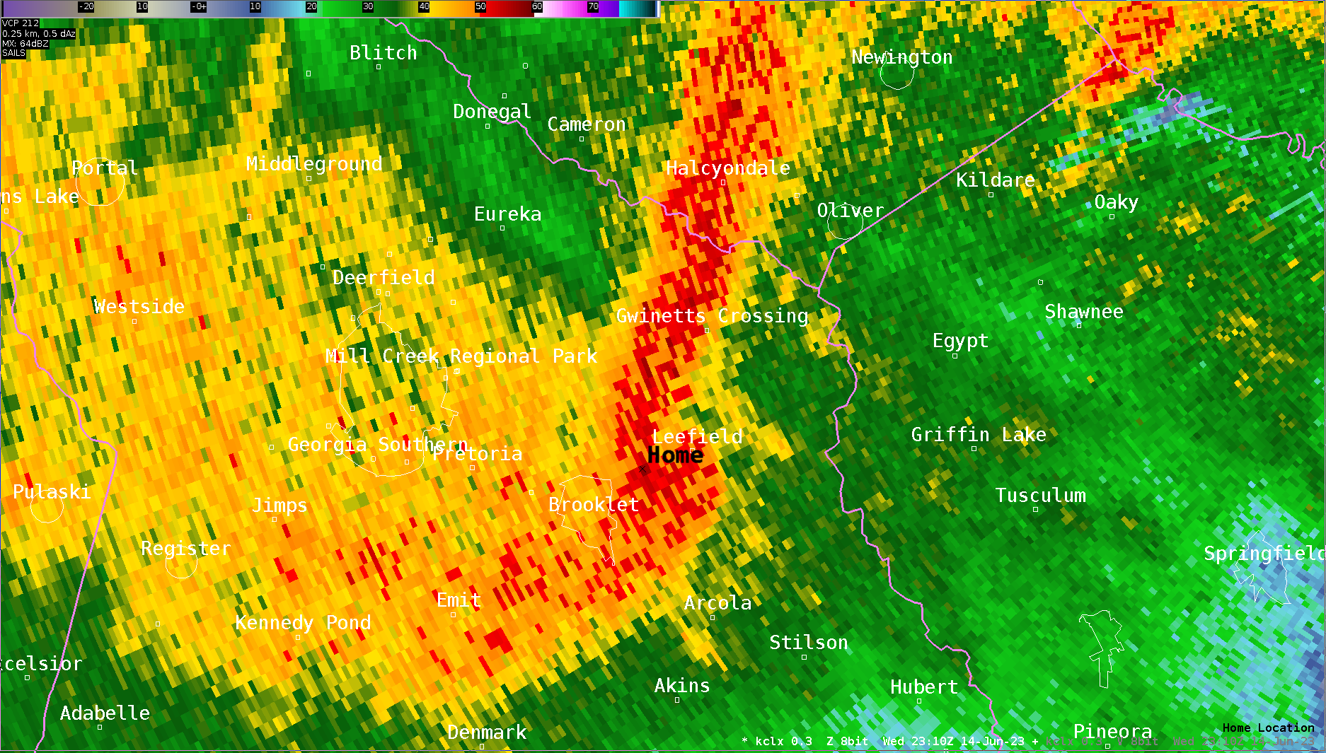
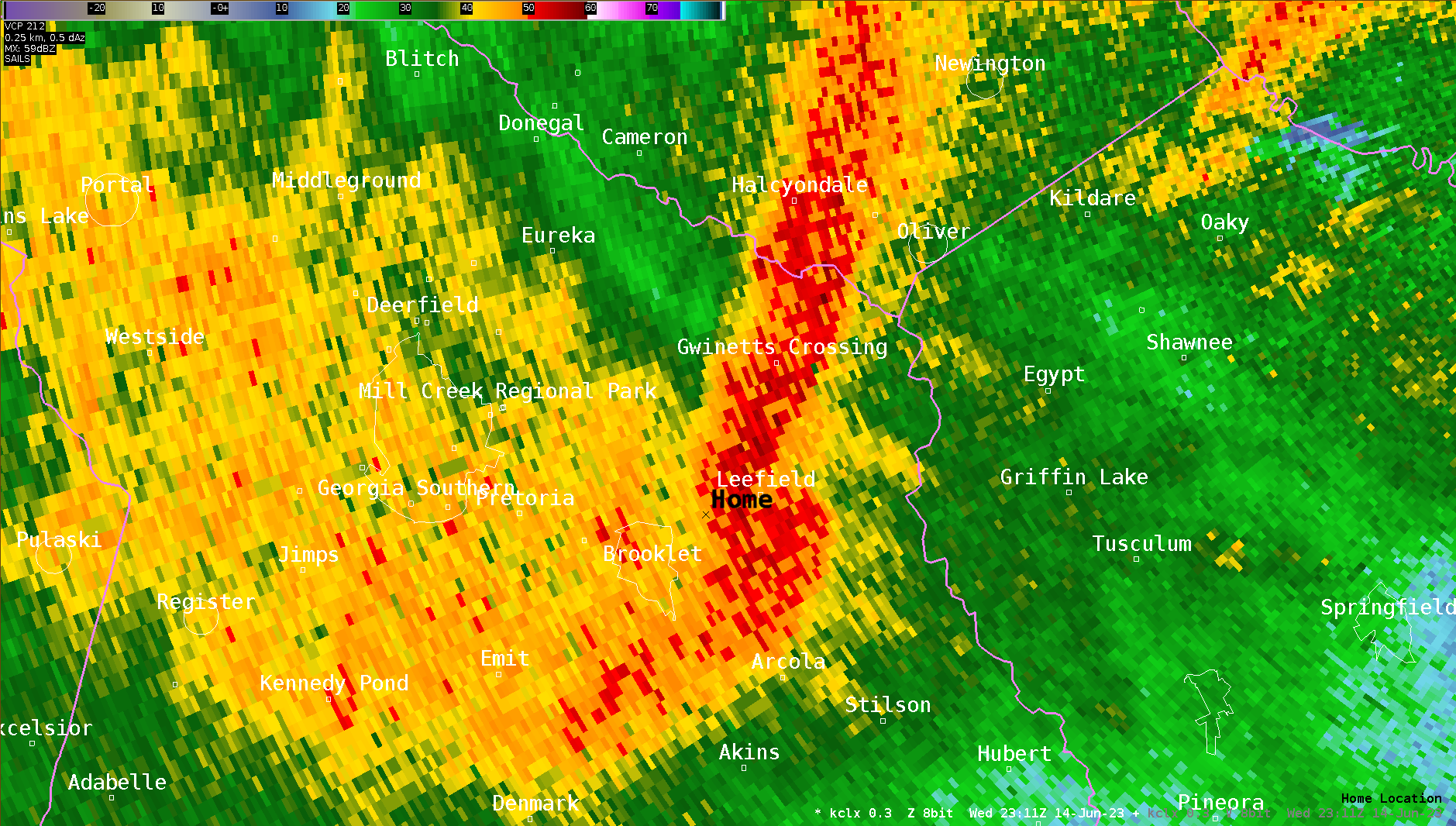
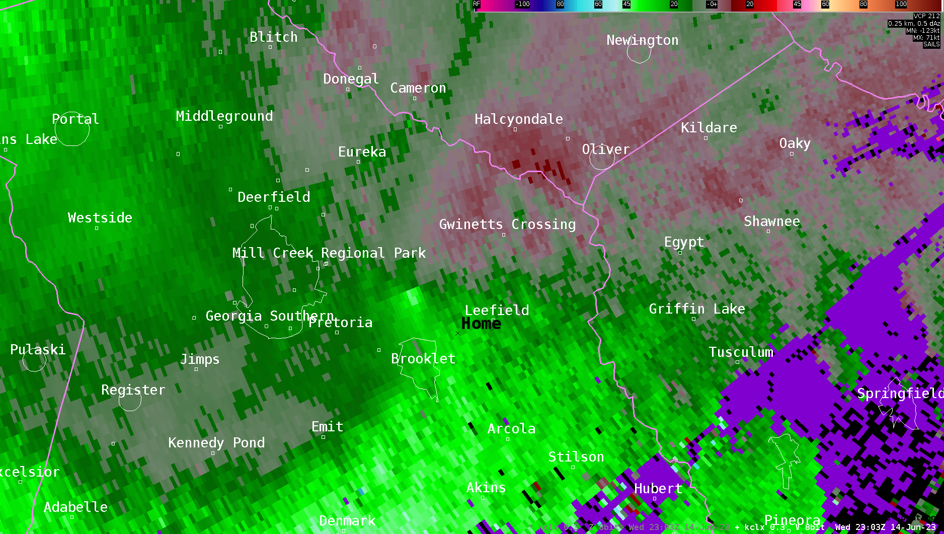
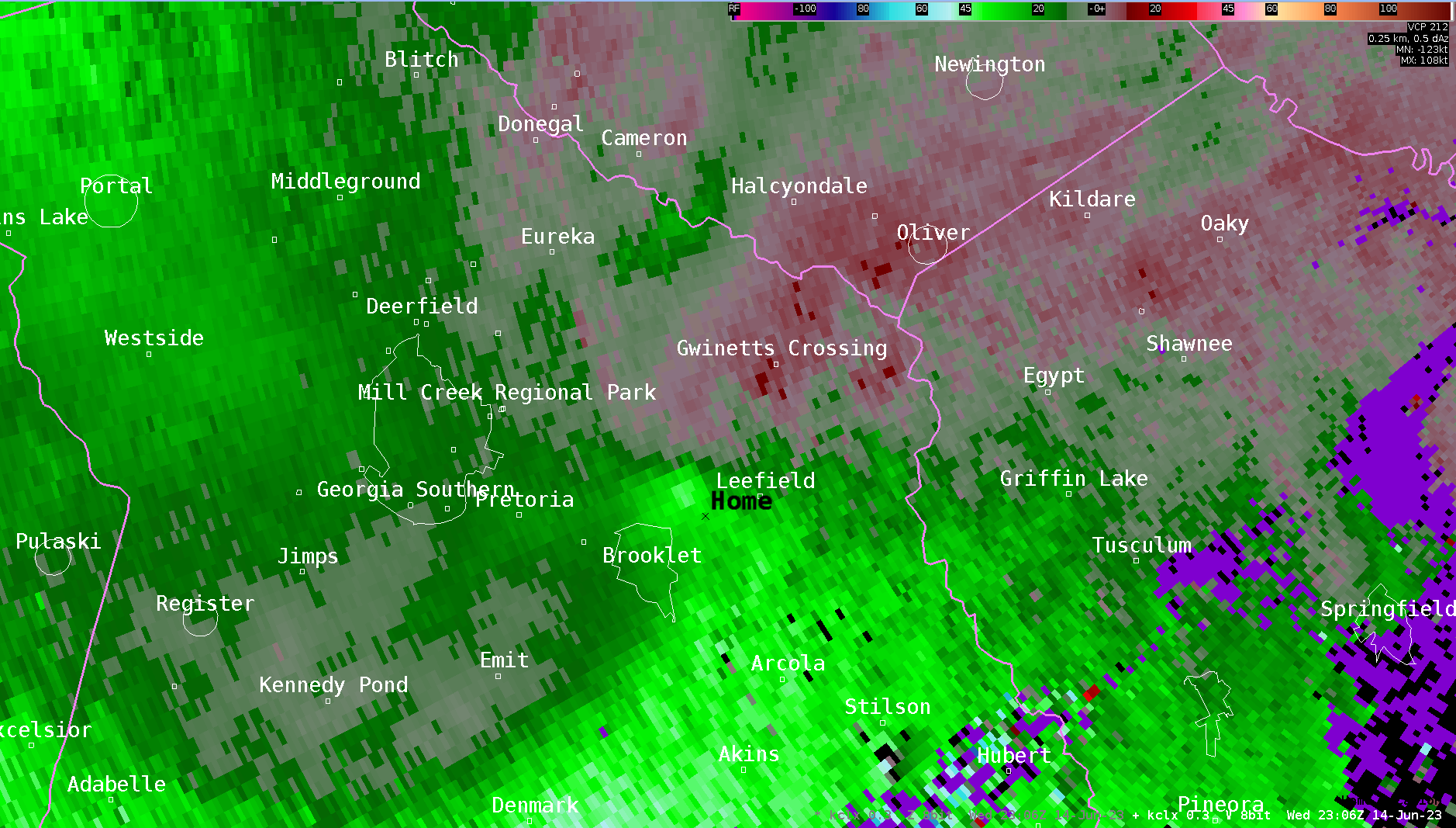
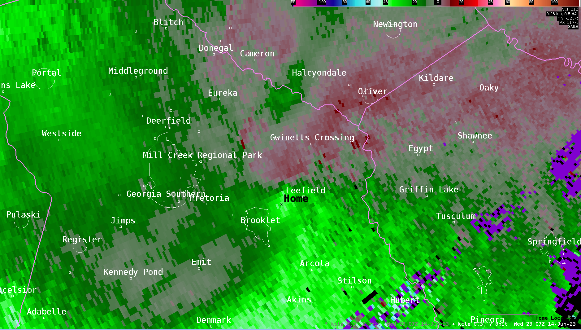
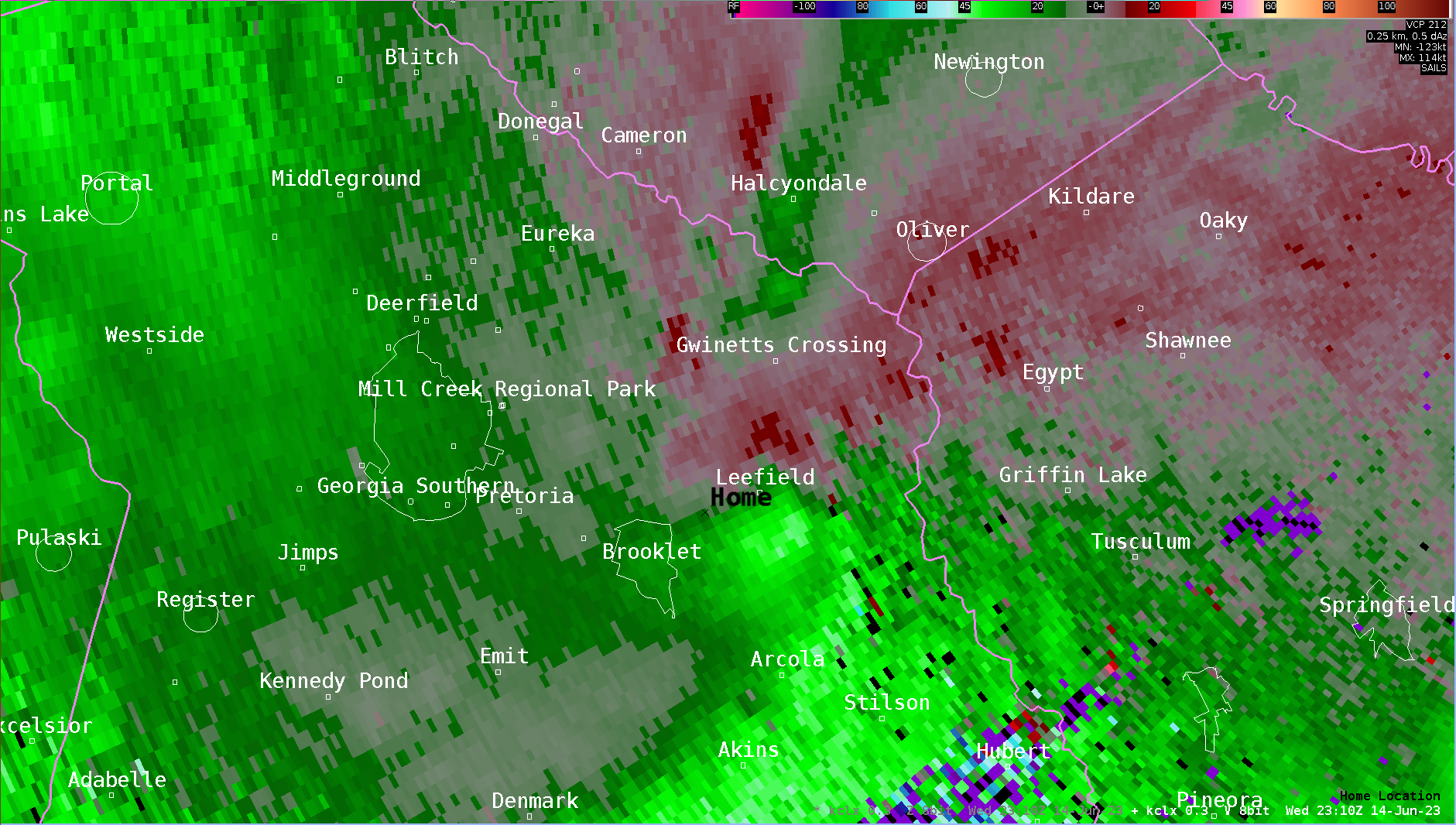
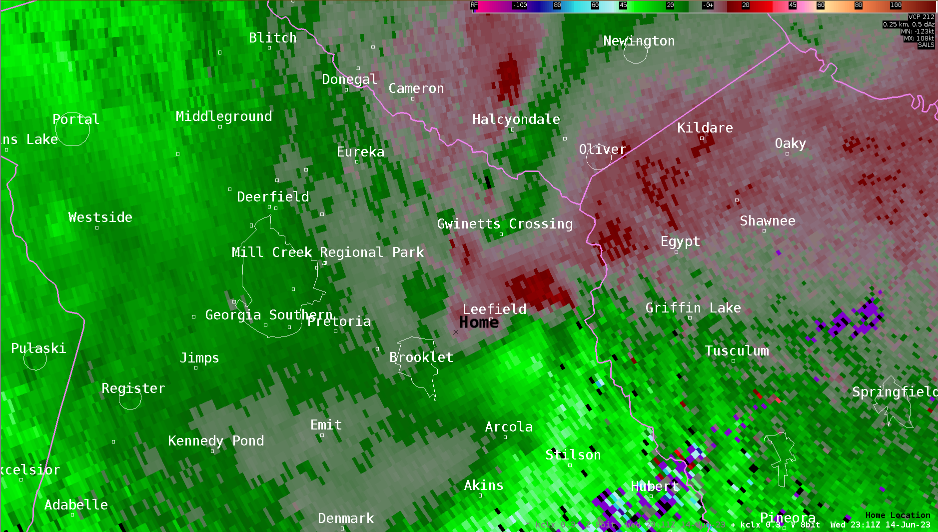
A brief tornado was confirmed just south of Brooklet-Leefield and Clito Road intersection. The tornado briefly touched down in a farm field along a thin line of trees where several hardwood trees were uprooted. The tornado then traveled across the field to a pine plantation where it uprooted and snapped nearly a third of the pine trees. A drone flight confirmed a distinctive convergent pattern in the trees. The tornado then quickly lifted once it entered back into the adjacent farm field. |
|||||||
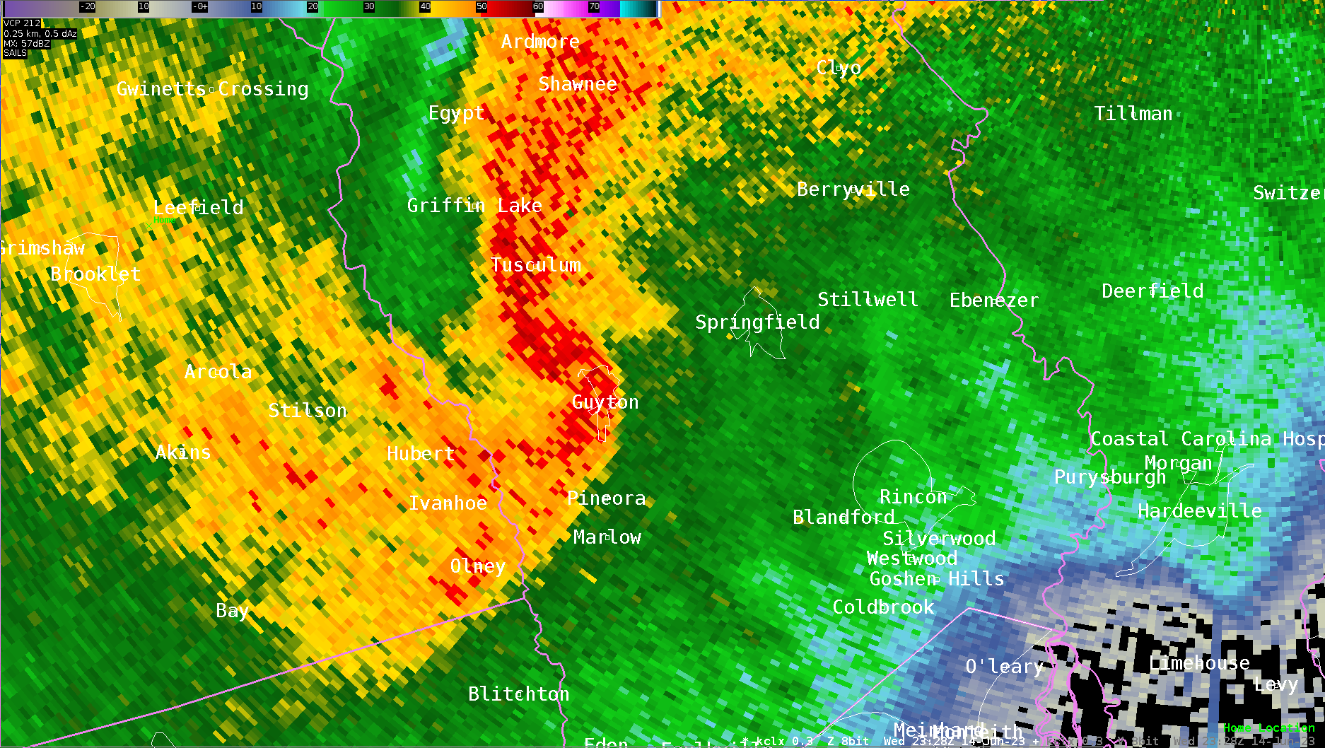
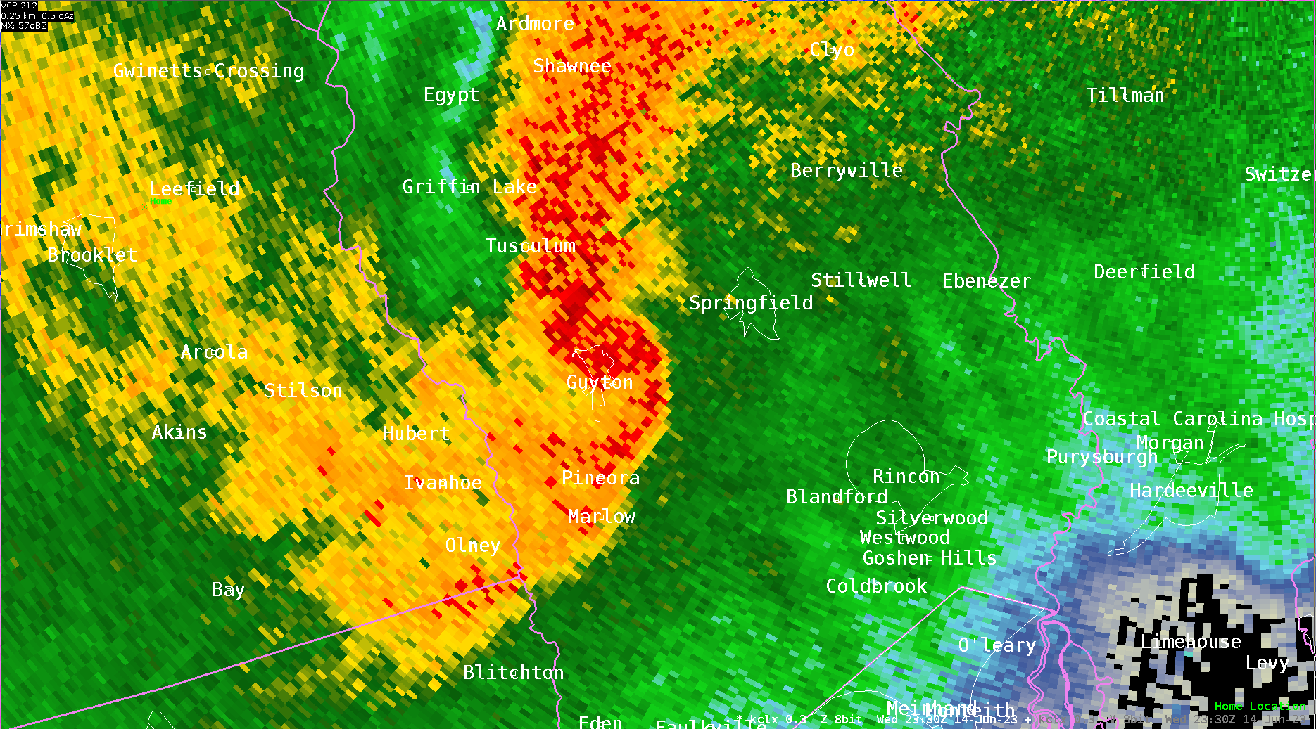
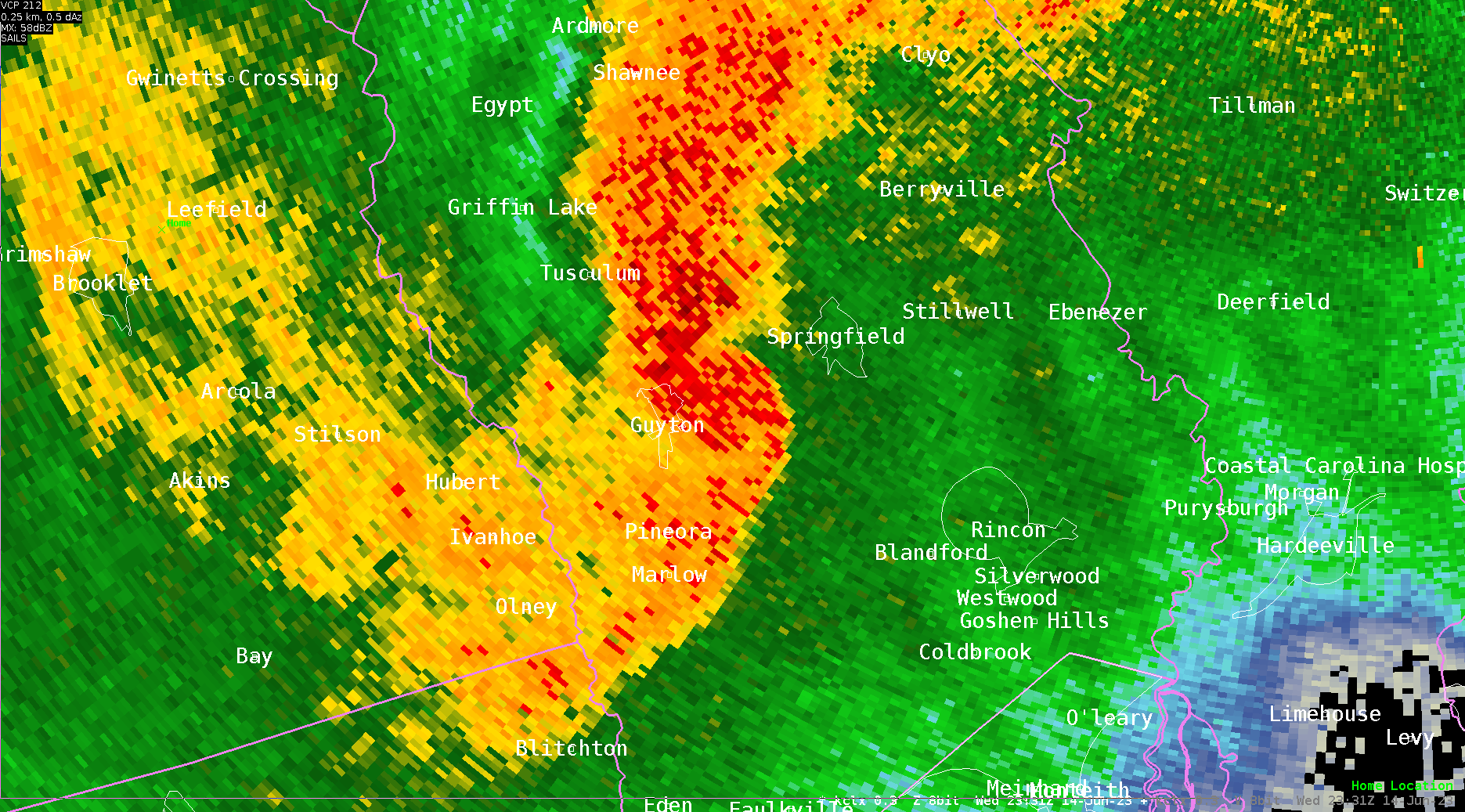
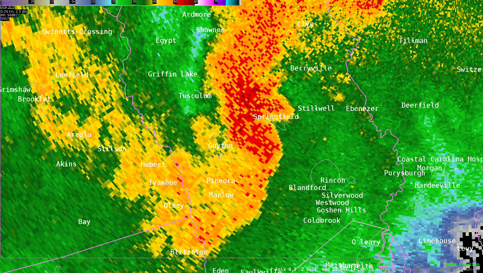
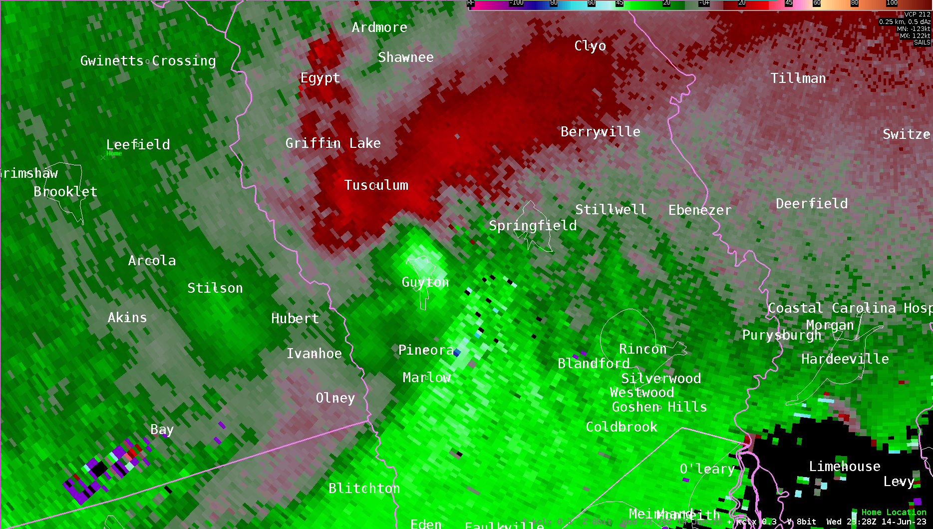
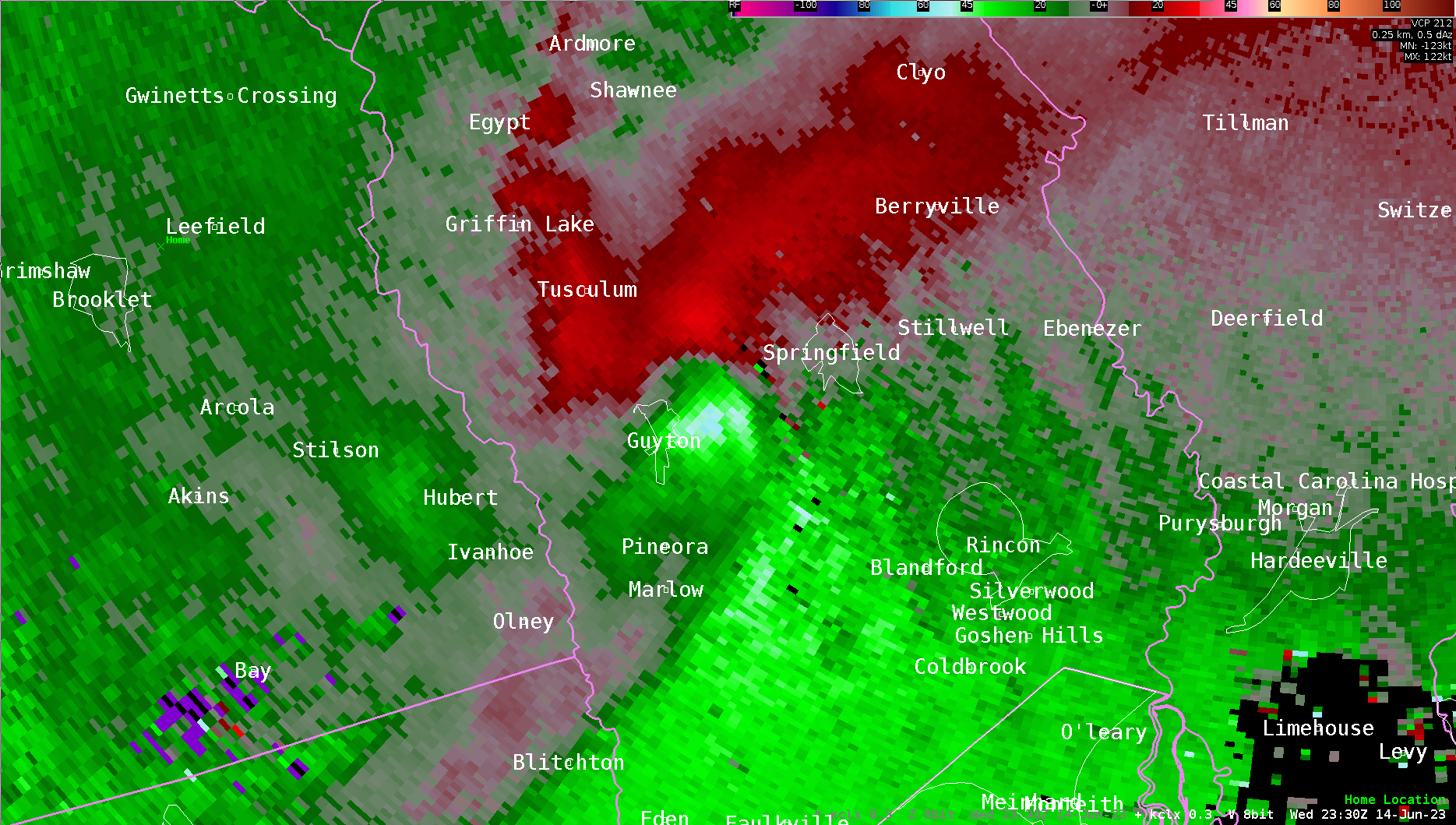
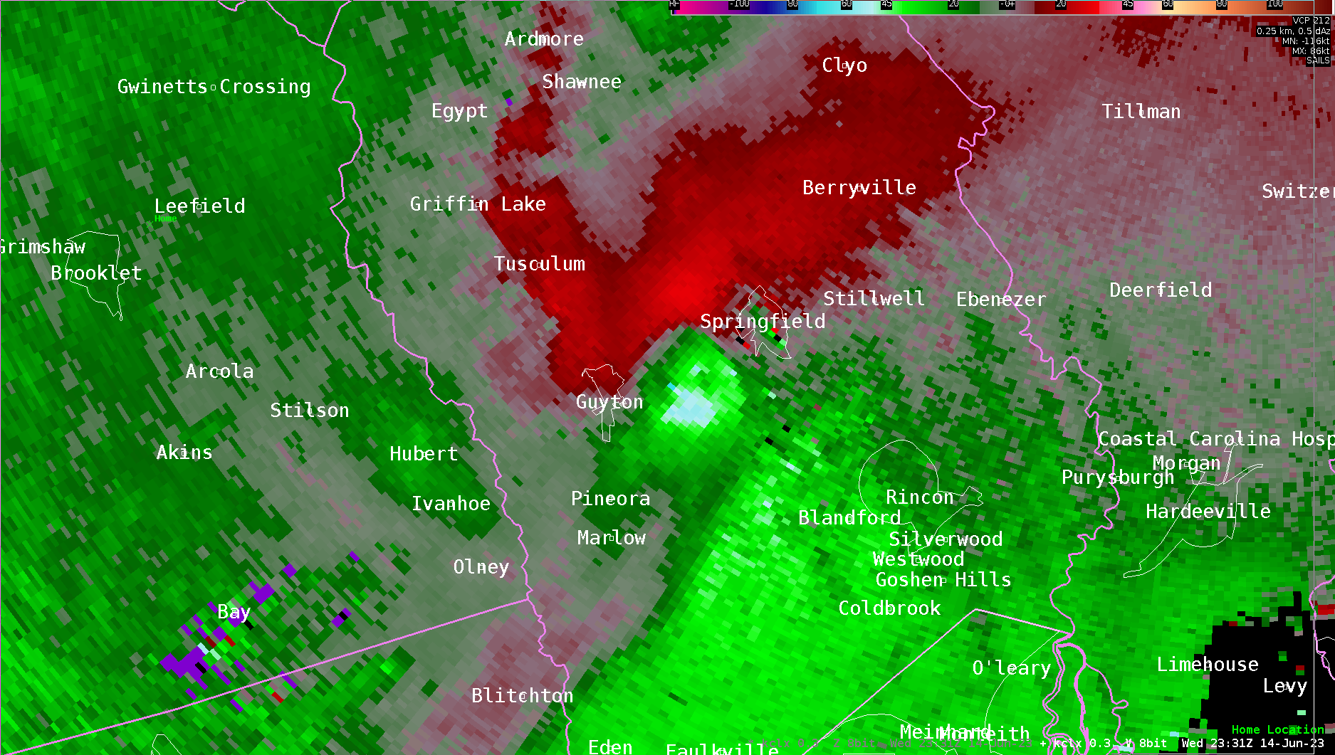
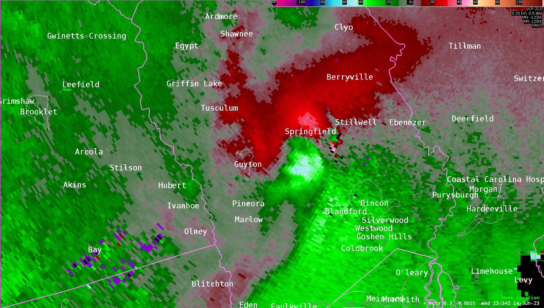
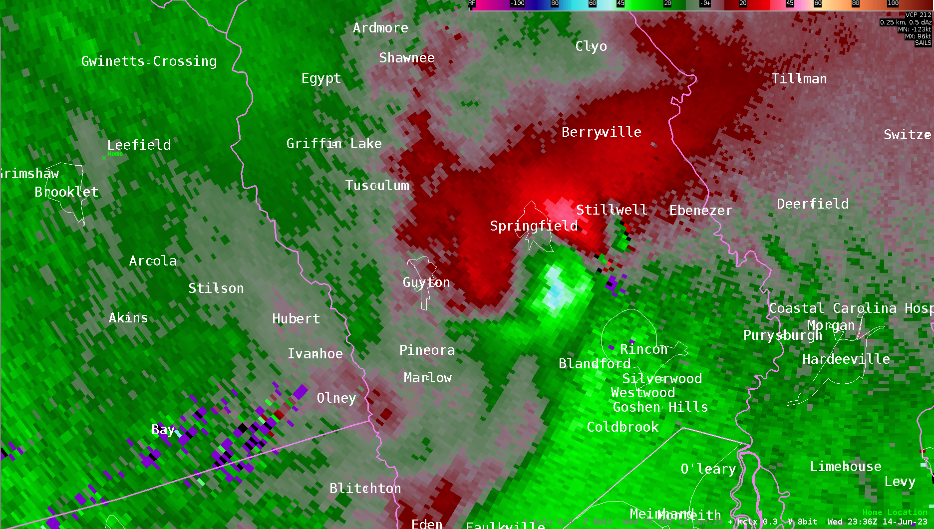
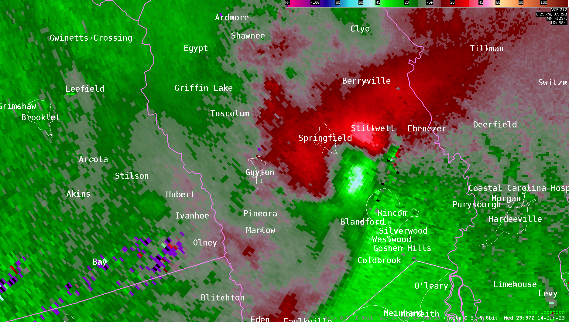
Radar Images (click on the X below to enlarge) |
|||||||
|
|
||||||
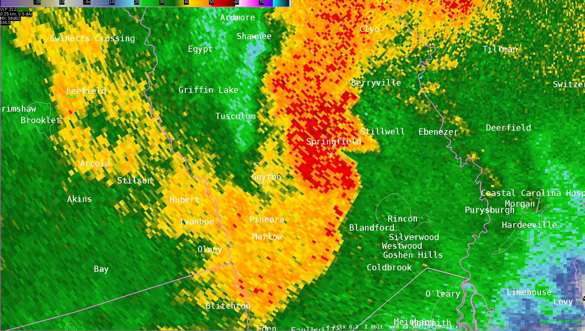
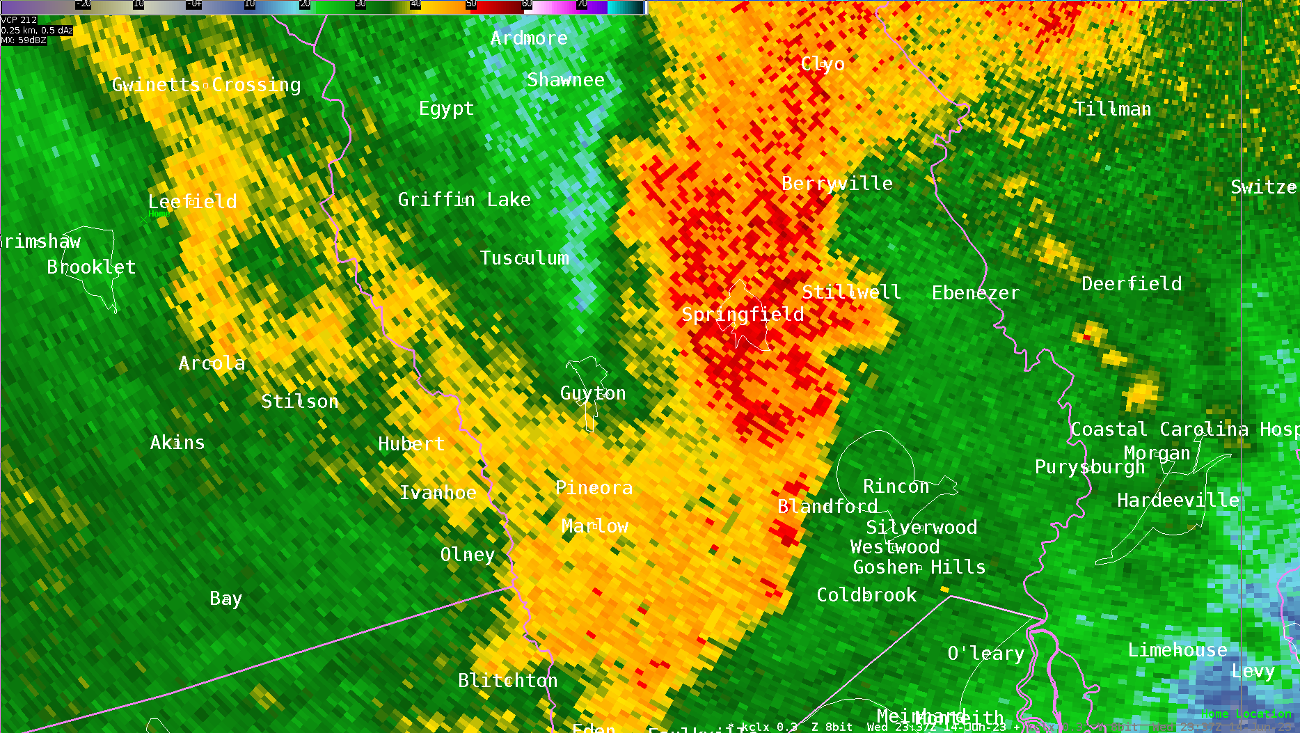
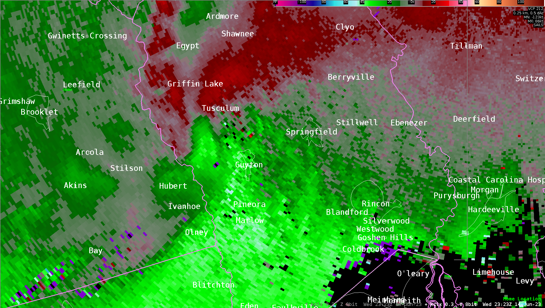
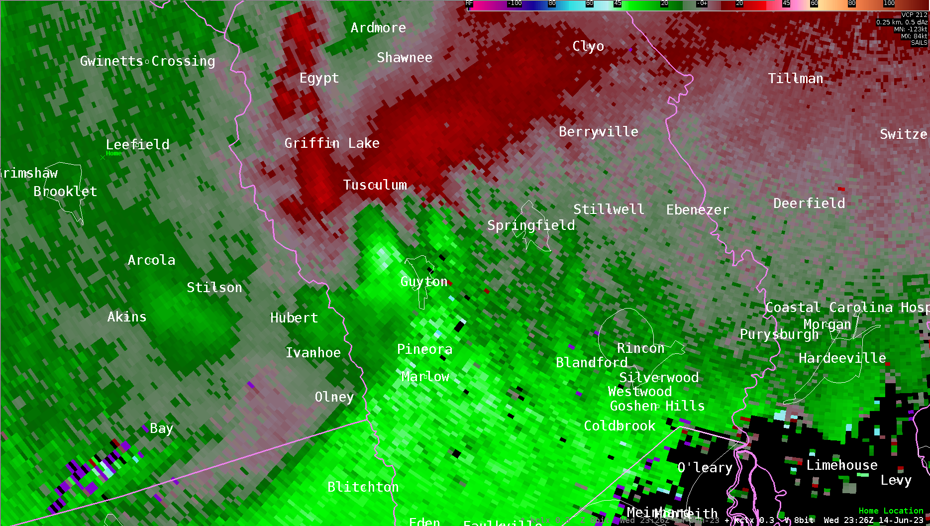
| EF1 Tornado near Guyton, GA (Effingham County) | |||||||
| Start Time | End Time | Max EF-Scale Rating | Max Wind Speed | Max Path Width | Path Length | Fatalities | Injuries |
|---|---|---|---|---|---|---|---|
| 7:27 PM EDT | 7:35 PM EDT | EF1 | 90 mph | 280 Yards | 7.09 Miles | 0 | 0 |
|
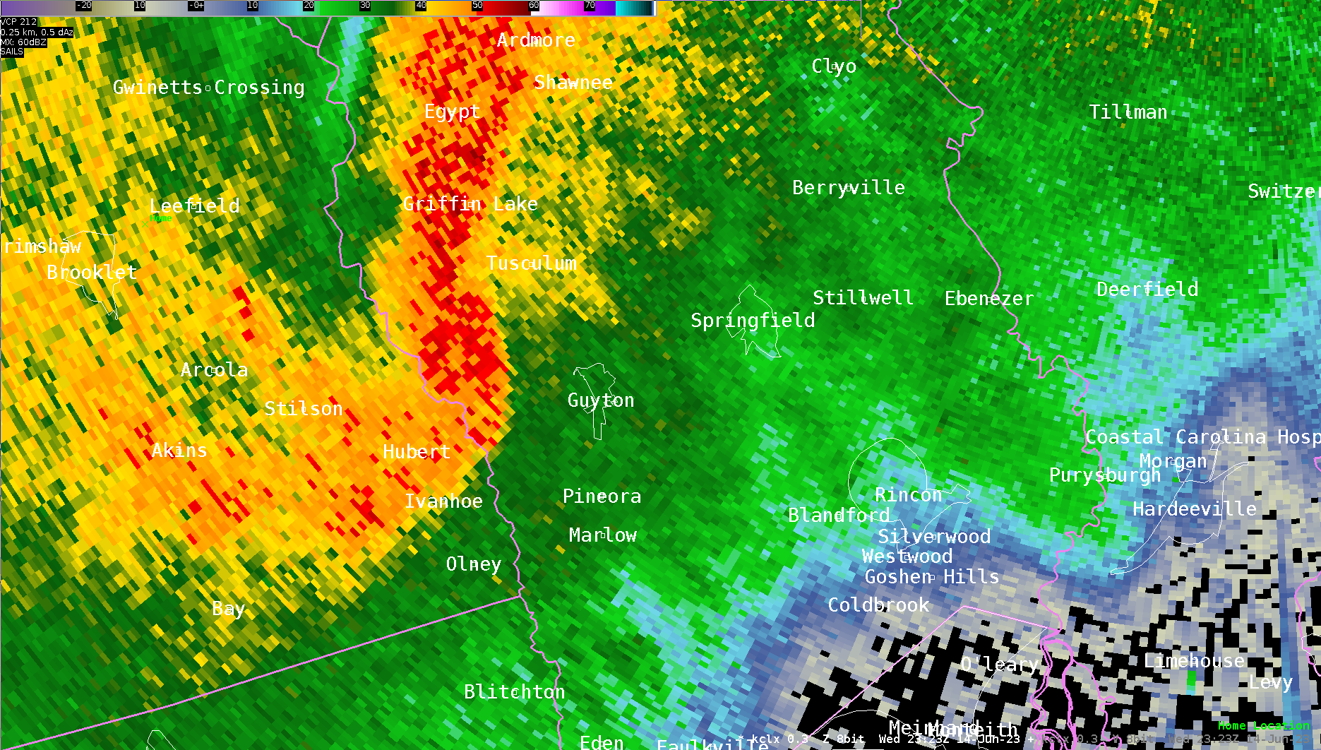
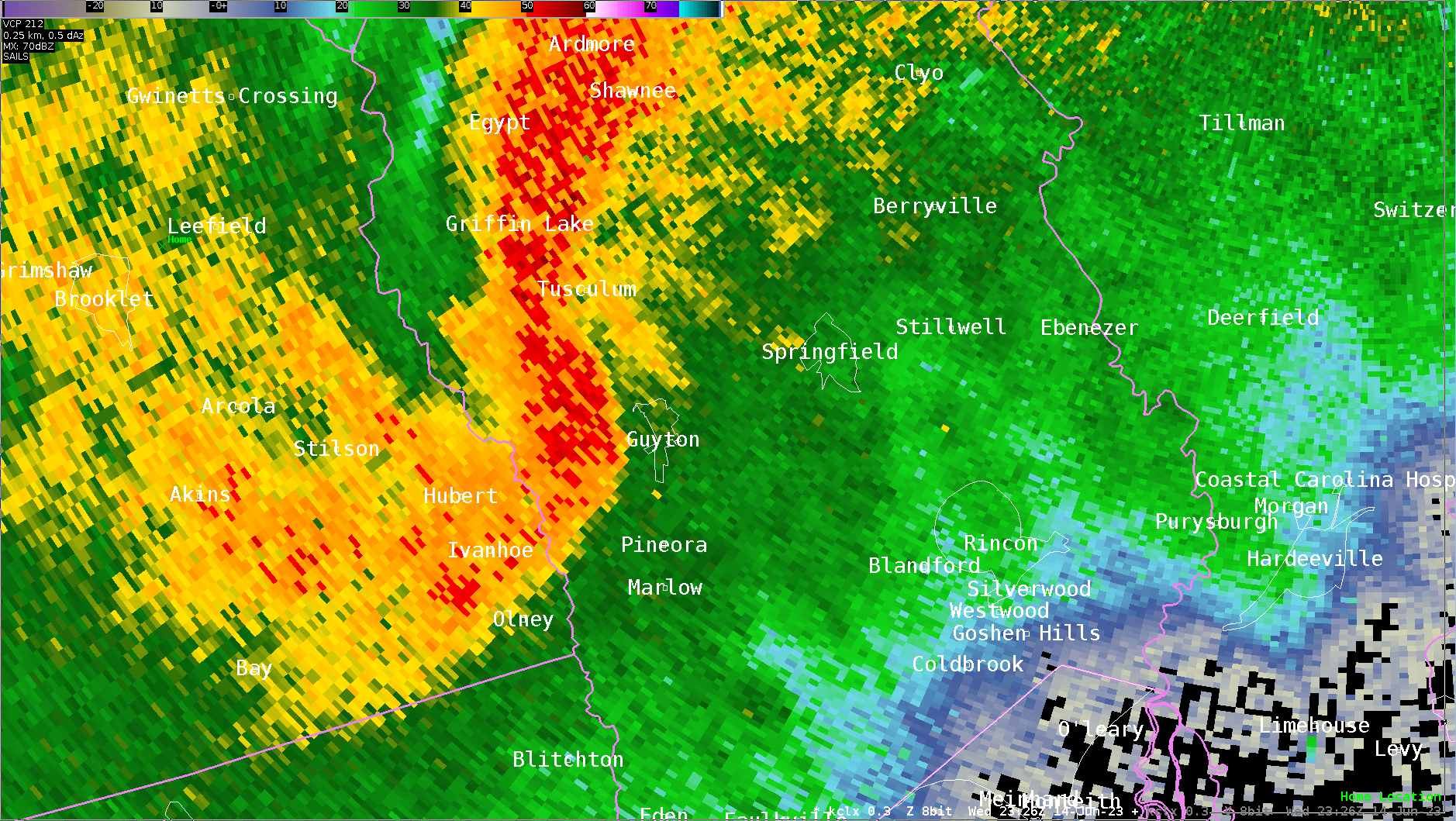
Tornado damage began near the intersection of Newton Road and Old Louisville Road with several trees snapped and uprooted. The tornado then tracked through the northern side of Guyton, GA, with mostly tree damage. It then moved southeast along the northern side of Little McCall Road where it snapped and uprooted multiple trees and removed a small amount of roof fascia and shingles from a couple of homes. The tornado then lifted before reaching Courthouse Road where no damage was observed. Paralleling the tornado track to the south was significant damage caused by straight-line winds from the rear flank downdraft, where snapped and uprooted trees were observed. |
|||||||
Radar Images (click on the X below to enlarge) |
||||||
|
|
|||||

Preliminary Local Storm Report...Summary
National Weather Service Charleston SC
1000 PM EDT Thu Jun 15 2023

..TIME...   ...EVENT...      ...CITY LOCATION...     ...LAT.LON...
..DATE...   ....MAG....      ..COUNTY LOCATION..ST.. ...SOURCE....
            ..REMARKS..

1023 AM     Tstm Wnd Dmg     Claxton                 32.16N  81.90W
06/14/2023                   Evans              GA   Law Enforcement

            Claxton Sheriff reported 1 tree down on Stewart St in
            Claxton.

0641 PM     Tstm Wnd Dmg     1 NE Portal             32.55N  81.92W
06/14/2023                   Bulloch            GA   Emergency Mngr

            A tree reported down at Rocky Ford Rd and Two Chop Rd.
            Time estimated from radar.

0641 PM     Tstm Wnd Dmg     Portal                  32.54N  81.93W
06/14/2023                   Bulloch            GA   Emergency Mngr

            Power lines reported down along the 400 block of
            Johnson Street. Time estimated from radar.

0645 PM     Funnel Cloud     5 ENE Altman            32.75N  81.55W
06/14/2023                   Screven            GA   911 Call Center

            A funnel cloud was sighted along Buck Creek Rd at Hound
            Dog Rd.

0654 PM     Tstm Wnd Dmg     Statesboro              32.44N  81.79W
06/14/2023                   Bulloch            GA   911 Call Center

            A 911 call center reported a tree down near the
            intersection of S College St and W Jones Ave. Time was
            estimated via radar data.

0658 PM     Tstm Wnd Dmg     1 ESE Georgia Southern  32.41N  81.76W
06/14/2023                   Bulloch            GA   911 Call Center

            A 911 call center reported a tree down along Hwy 67
            near Stambuk Lane. Time was estimated via radar data.

0658 PM     Tstm Wnd Dmg     3 NE Statesboro         32.48N  81.75W
06/14/2023                   Bulloch            GA   Emergency Mngr

            Tree reported down at Highway 301 and Randy Lowery
            Road. Time estimated from radar.

0659 PM     Tstm Wnd Dmg     1 ESE Georgia Southern  32.41N  81.76W
06/14/2023                   Bulloch            GA   Emergency Mngr

            Power lines reported down along Highway 67 at the
            Garden District. Time estimated from radar.

0701 PM     Tstm Wnd Gst     Statesboro Municipal Ai 32.48N  81.74W
06/14/2023  M53 mph          Bulloch            GA   AWOS

0701 PM     Tstm Wnd Dmg     4 SW Brooklet           32.35N  81.71W
06/14/2023                   Bulloch            GA   Emergency Mngr

            Tree down on Beulah Lane at Emit Grove Rd.

0706 PM     Tstm Wnd Dmg     2 WNW Leefield          32.43N  81.64W
06/14/2023                   Bulloch            GA   911 Call Center

            911 call center reported a tree down near the
            intersection of Clito Rd and Magnolia Church Rd. Time
            was estimated via radar data.

0708 PM     Tornado          2 WSW Leefield          32.41N  81.64W
06/14/2023                   Bulloch            GA   NWS Storm Survey

            A NWS survey team confirmed a brief tornado near the
            Brooklet-Leefield & Clito Road intersection. The tornado
            briefly touched down in a field along a thin line of
            trees where several hardwood trees were uprooted. It
            then traveled across the field to a pine plantation
            where it uprooted & snapped nearly a third of the trees.
            The tornado then lifted once it entered the adjacent
            farm field. The tornado is rated EF-0 with max winds of
            80 mph. Path length was 0.19 mile with a path width of
            250 yards.

0710 PM     Tstm Wnd Dmg     2 SE Leefield           32.40N  81.59W
06/14/2023                   Bulloch            GA   911 Call Center

            A 911 call center reported a tree and power lines down
            along Leefield Rd near Holloway Rd. Time was estimated
            via radar data.

0710 PM     Tstm Wnd Dmg     1 W Leefield            32.42N  81.62W
06/14/2023                   Bulloch            GA   Emergency Mngr

            Multiple trees snapped off about 6 or 7 feet off the
            ground along Brooklet-Leefield Rd.

0711 PM     Tstm Wnd Dmg     2 SE Leefield           32.40N  81.59W
06/14/2023                   Bulloch            GA   Emergency Mngr

            Power lines reported down on Stilson-Leefield Road at
            Holloway Road. Time estimated from radar.

0711 PM     Tstm Wnd Dmg     4 WSW Newington         32.58N  81.57W
06/14/2023                   Screven            GA   911 Call Center

            A tree was blown down on a house on Ennis School Rd.

0716 PM     Tstm Wnd Dmg     3 N Stilson             32.38N  81.55W
06/14/2023                   Bulloch            GA   Emergency Mngr

            Multiple trees down on S Old River Rd at Shuman Rd.

0727 PM     Tornado          3 WNW Guyton            32.36N  81.44W
06/14/2023                   Effingham          GA   NWS Storm Survey

            A National Weather Service damage survey team found
            that a tornado touchdown just northwest of Guyton, GA
            and travelled southeast across the northern portions of
            the town before lifting near the intersection of Little
            McCall Road and Courthouse Road. The tornado is rated
            EF-1 with max winds of 90 mph. The preliminary track
            length is 7.09 miles. Path width is 280 yards.

0728 PM     Tstm Wnd Dmg     Guyton                  32.34N  81.40W
06/14/2023                   Effingham          GA   Emergency Mngr

            Emergency manager reported a tree down along the 500
            block of W Central Blvd. Time was estimated via radar
            data.

0728 PM     Tstm Wnd Dmg     Guyton                  32.34N  81.39W
06/14/2023                   Effingham          GA   Emergency Mngr

            Emergency manager reported a tree down near 4th St Ext
            and Poplar St. Time was estimated via radar.

0728 PM     Tstm Wnd Dmg     Guyton                  32.34N  81.39W
06/14/2023                   Effingham          GA   Emergency Mngr

            Emergency manager relayed a report of a tree on top of
            a roof along the 500 block of Magnolia St. Roof damage
            reported, but extent of damage is unknown. Time was
            estimated via radar data.

0728 PM     Tstm Wnd Dmg     2 NW Guyton             32.35N  81.41W
06/14/2023                   Effingham          GA   Emergency Mngr

            Emergency manager reported a tree down along Hwy 17
            near Sunrise Dr possibly due to a tornado. Time was
            estimated via radar data.

0730 PM     Tstm Wnd Dmg     Guyton                  32.34N  81.39W
06/14/2023                   Effingham          GA   Emergency Mngr

            Emergency manager reports a tree down near the 300
            block of 6th Ave possibly due to a tornado. Time was
            estimated via radar data.

0734 PM     Tstm Wnd Dmg     4 ESE Guyton            32.32N  81.32W
06/14/2023                   Effingham          GA   Emergency Mngr

            Emergency manager reported a tree down near Little
            McCall Rd and Courthouse Rd due to a possible tornado.
            Time was estimated via radar data.

0734 PM     Tstm Wnd Dmg     3 ESE Springfield       32.35N  81.33W
06/14/2023                   Effingham          GA   Emergency Mngr

            Emergency manager reported a tree down along Hwy 119
            near Forest Rd possibly due to a tornado. Time was
            estimated via radar data.

0736 PM     Tstm Wnd Dmg     5 SSE Ruffin            32.95N  80.78W
06/14/2023                   Colleton           SC   Emergency Mngr

            Emergency manager reports tree down on the 100 block of
            Tabor Rd blocking both lanes. Time was estimated via
            radar data.

0736 PM     Tstm Wnd Dmg     6 NNE Manassas          32.24N  82.00W
06/14/2023                   Evans              GA   911 Call Center

            Tree and debris in roadway at Kennedy Bridge Rd at HWY
            129 S.

0737 PM     Tstm Wnd Dmg     1 N Statesboro          32.47N  81.78W
06/14/2023                   Bulloch            GA   Emergency Mngr

            Tree down on N Main St at Debbie Dr.

0737 PM     Tstm Wnd Dmg     3 E Hopeulikit          32.53N  81.80W
06/14/2023                   Bulloch            GA   Emergency Mngr

            Tree down at 462 E C Hunnicutt Rd.

0737 PM     Tstm Wnd Dmg     1 N Statesboro          32.47N  81.78W
06/14/2023                   Bulloch            GA   Emergency Mngr

            Power lines reported down on N Main Street at Debbie
            Drive. Time estimated from radar.

0739 PM     Tstm Wnd Dmg     4 ENE Eden              32.20N  81.33W
06/14/2023                   Effingham          GA   Emergency Mngr

            Emergency manager reported a tree on power lines along
            Hester Rd near Brittany Ln. Time was estimated via radar
            data.

0739 PM     Tstm Wnd Dmg     Bellville               32.16N  81.98W
06/14/2023                   Evans              GA   911 Call Center

            Tree down on Hugh Brewton Rd north of Bellville.

0741 PM     Tstm Wnd Dmg     Hagan                   32.16N  81.93W
06/14/2023                   Evans              GA   Emergency Mngr

            Tree down on Hugh Brewton Rd at HWY 280.

0742 PM     Tstm Wnd Dmg     4 ENE Eden              32.20N  81.33W
06/14/2023                   Effingham          GA   Emergency Mngr

            Emergency manager reported a tree down along the 100
            block of St Matthews Rd. Time was estimated via radar
            data.

0743 PM     Tstm Wnd Dmg     2 SSE Stillwell         32.35N  81.23W
06/14/2023                   Effingham          GA   Public

            Report of a tree down with roof damage at the 100 block
            of Henry Ct. Extent of damage is unknown.

0743 PM     Tstm Wnd Dmg     Claxton                 32.16N  81.90W
06/14/2023                   Evans              GA   911 Call Center

            Tree down at Long St and Sherry St in Claxton.

0743 PM     Tstm Wnd Dmg     5 NNE Claxton           32.23N  81.88W
06/14/2023                   Evans              GA   911 Call Center

            Tree down on Red Clay Rd at US 301N.

0746 PM     Tstm Wnd Dmg     2 W Daisy               32.15N  81.87W
06/14/2023                   Evans              GA   911 Call Center

            2 trees down on Sims Brothers Rd.

0749 PM     Tstm Wnd Dmg     Pooler                  32.11N  81.25W
06/14/2023                   Chatham            GA   Emergency Mngr

            Emergency manager reported a tree down on power lines
            near the intersection of Sheftall and Tietgen St. Time
            was estimated via radar data.

0749 PM     Tstm Wnd Dmg     3 SE Canadys            33.02N  80.58W
06/14/2023                   Colleton           SC   Emergency Mngr

            Emergency manager reports a tree down blocking both
            lanes along the 7700 block of Pleasant Grove Rd. Time
            was estimated via radar data.

0751 PM     Tstm Wnd Dmg     1 S Hardeeville         32.27N  81.08W
06/14/2023                   Jasper             SC   Broadcast Media

            Media reports power lines down across I-95 in
            Hardeeville. Both southbound and northbound lanes are
            closed near exit 5. Time was estimated via radar data.

0751 PM     Tstm Wnd Gst     Savannah Airport        32.13N  81.20W
06/14/2023  M46 mph          Chatham            GA   ASOS

            A 46 mph wind gust was measured at the Savannah/Hilton
            Head International Airport (KSAV).

0754 PM     Tstm Wnd Dmg     Hardeeville             32.29N  81.08W
06/14/2023                   Jasper             SC   911 Call Center

            A 911 call center reported numerous downed trees and
            power lines in the Hardeeville area. Time was estimated
            via radar data.

0755 PM     Tstm Wnd Dmg     1 SE Hardeeville        32.28N  81.07W
06/14/2023                   Jasper             SC   911 Call Center

            A 911 call center reported a downed tree on an
            apartment building near the 100 block of Walsh Dr.
            Structural damage was reported, but the extent is
            unknown. Time was estimated via radar data.

0758 PM     Tstm Wnd Dmg     3 NNW Pritchardville    32.28N  80.98W
06/14/2023                   Beaufort           SC   911 Call Center

            Tree blown down on an apartment complex.

0759 PM     Tstm Wnd Dmg     Pritchardville          32.24N  80.97W
06/14/2023                   Beaufort           SC   911 Call Center

            1 tree down at the intersection of Mayriver Road and
            Stillwell.

0759 PM     Tstm Wnd Dmg     3 ENE Hardeeville       32.30N  81.03W
06/14/2023                   Jasper             SC   911 Call Center

            A 911 call center reported trees and power lines down
            along the 1500 block of Brick Yard Rd. Time was
            estimated via radar data.

0802 PM     Tstm Wnd Dmg     3 NE Pritchardville     32.27N  80.94W
06/14/2023                   Beaufort           SC   911 Call Center

            1 tree down at the intersection of Bluffton Parkway and
            Hampton Parkway.

0802 PM     Tstm Wnd Dmg     4 NNE Pritchardville    32.29N  80.94W
06/14/2023                   Beaufort           SC   911 Call Center

            3 trees blown down along Del Webb Blvd and Oaktie
            Highway.

0807 PM     Tstm Wnd Dmg     1 NNW Bluffton          32.25N  80.86W
06/14/2023                   Beaufort           SC   911 Call Center

            Tree on house at 40 Wilkerson Way.

0808 PM     Tstm Wnd Dmg     4 WNW Bluffton          32.27N  80.91W
06/14/2023                   Beaufort           SC   Fire Dept/Rescue

            Report of a tree down near Buckwalter Parkway and Lake
            Point Dr. Time was estimated via radar data.

0808 PM     Tstm Wnd Dmg     1 S Bluffton            32.22N  80.86W
06/14/2023                   Beaufort           SC   911 Call Center

            Tree down at 24 Kirk Bluff Road.

0810 PM     Tstm Wnd Dmg     2 W Bluffton            32.24N  80.89W
06/14/2023                   Beaufort           SC   Fire Dept/Rescue

            Report of a tree down near May River Rd and Linden Park
            Dr. Time was estimated via radar data.

0810 PM     Tstm Wnd Dmg     5 SSW Daisy             32.09N  81.85W
06/14/2023                   Evans              GA   911 Call Center

            Tree down in road at HWY 129 at Old HWY 250.

0811 PM     Tstm Wnd Dmg     3 WSW Beaufort          32.42N  80.72W
06/14/2023                   Beaufort           SC   911 Call Center

            Tree down at 1302 Jericho Road.

0812 PM     Tstm Wnd Gst     3 WNW Fort Screven      32.03N  80.90W
06/14/2023  M41 mph          Chatham            GA   Other Federal

            The NOS tide gauge at Fort Pulaski measured a 36 knot
            (41 mph) wind gust.

0819 PM     Tstm Wnd Dmg     1 S Walthourville       31.77N  81.63W
06/14/2023                   Liberty            GA   911 Call Center

            1 tree down on Griffin Rd at Arnall Dr.

0830 PM     Tstm Wnd Dmg     2 N Crossroads          31.77N  81.46W
06/14/2023                   Liberty            GA   911 Call Center

            Several trees down on Lewis Frasier Rd and Slade Rd.

0848 PM     Tstm Wnd Dmg     3 SW Sunbury            31.74N  81.31W
06/14/2023                   Liberty            GA   911 Call Center

            1 tree down on Old Seabrook School Rd.

0900 PM     Tstm Wnd Gst     2 NW Sapelo Island      31.42N  81.30W
06/14/2023  M51 mph          McIntosh           GA   Other Federal

            The NERRS site at the south end of Sapelo Island
            measured a 44 knot (51 mph) wind gust.

0924 PM     Tstm Wnd Gst     22 ESE Racccon Bluff    31.40N  80.87W
06/14/2023  M47 mph          AMZ354             GA   Buoy

            Buoy 41008 measured a 41 knot (47 mph) wind gust.

1023 PM     Non-Tstm Wnd Gst 2 WSW Folly Beach       32.64N  79.97W
06/14/2023  M41 mph          Charleston         SC   Mesonet

            A wind gust of 36 kt was measured at the Folly Beach
            South End Weatherflow station.

1241 AM     Non-Tstm Wnd Gst 6 WSW Forest Beach      32.11N  80.84W
06/15/2023  M41 mph          AMZ352             SC   Mesonet

            The Weatherflow site in Calibogue Sound measured a 36
            knot wind gust.

0104 AM     Non-Tstm Wnd Gst 1 SSW Tybee Island      31.99N  80.85W
06/15/2023  M54 mph          Chatham            GA   Mesonet

            The Weatherflow site on the south end of Tybee Island
            measured a 47 knot wind gust.

0105 AM     Non-Tstm Wnd Gst 2 ENE Tybee Island      32.01N  80.81W
06/15/2023  M46 mph          AMZ352             GA   Mesonet

            The Weatherflow site at Savannah Entrance Light
            measured a 40 knot wind gust.


 Coastal Flood