 |
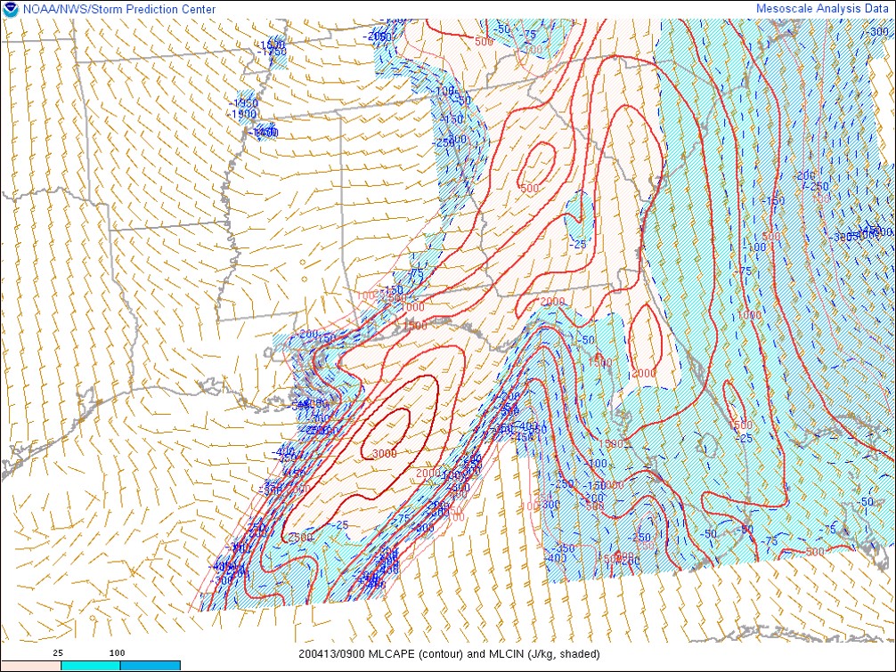
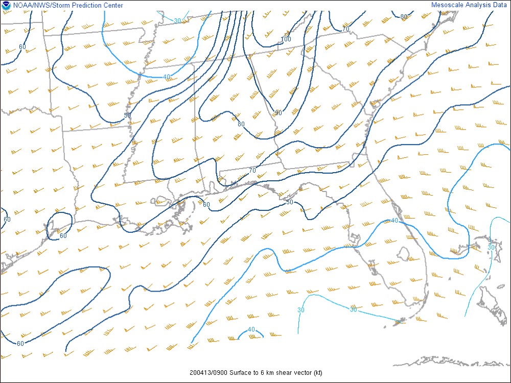
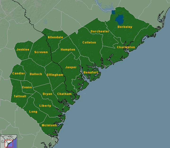
A severe squall line moved through southeast South Carolina and northern portions of southeast Georgia during the early morning of April 13, 2020 ahead of a strong cold front. The environment ahead of the squall line was unusually unstable for this time of year (and especially for the time of day) with mixed layer convective available potential energy (MLCAPE) as high as ~2000 J/kg, and deep layer (0-6 km) shear was significant and supportive of organized convection capable of producing damaging winds and tornadoes. The NWS Storm Prediction Center had the area outlined for an "Enhanced" risk of severe thunderstorms. In the end, NWS Charleston received many reports of wind damage and was able to confirm 16 tornadoes across their area of responsibility as shown below, including the first EF4 on record across southeast SC. |
|
GOES IR Satellite Imagery Loop (526 AM EDT - 956 AM EDT) |
Click the tornado icons on the map to display the damage survey summaries and on the tornado tracks for tornado details.

 |
 |
 |
 |
 |
| EF0 | EF1 | EF2 | EF3 | EF4 |
(listed by start time from earliest to latest)
| EF1 Tornado in Screven County, GA/Hampton County, SC (Near Savannah River) | ||||||
| Start Time | Max EF-Scale Rating | Max Wind Speed | Max Path Width | Path Length | Fatalities | Injuries |
|---|---|---|---|---|---|---|
| 5:58 AM EDT | EF1 | 105 mph | 200 yards | 5.91 mi | 0 | 0 |
|
This tornado began on Weisman Road resulting in snapping and uprooting of many trees. The tornado moved eastward and crossed Newington Highway, where it did some damage to a mobile home and small cabin. The mobile home had trees down on it and the roof was removed.The cabin had a portion of the roof removed. The tornado then continued over a wooded area, with more snapping and uprooting of trees, finally dissipating in the marsh region just east of the Savannah River in Hampton County, SC. |
||||||
Radar Images (click to enlarge) |
||||||
|
KCLX 0.5 Degree Reflectivity (Z) (4/13/20 - 559 AM EDT) |
KCLX 0.5 Degree Storm-relative Velocity (SRM) (4/13/20 - 559 AM EDT) |
|||||
|
|
|
|||||
Damage Pictures (courtesy of NWS Charleston - click to enlarge) |
||||||
| EF0 Tornado in Allendale County, SC | ||||||
| Start Time | Max EF-Scale Rating | Max Wind Speed | Max Path Width | Path Length | Fatalities | Injuries |
|---|---|---|---|---|---|---|
| 6:04 AM EDT | EF0 | 76 mph | 300 yards | 5.87 mi | 0 | 0 |
|
This weak tornado touched down near the intersection of Route 321 and Mt. Pleasant Church Road. The tornado continued east-northeastward, crossed Bethel Church Road, then dissipated just northeast of the intersection of Route 641 and Rebel Drive. The tornado produced sporadic, discontinuous tree damage along this path. |
||||||
Radar Images (click to enlarge) |
||||||
|
KCLX 0.5 Degree Reflectivity (Z) (4/13/20 - 559 AM EDT) |
KCLX 0.5 Degree Storm-relative Velocity (SRM) (4/13/20 - 559 AM EDT) |
|||||
|
|
|
|||||
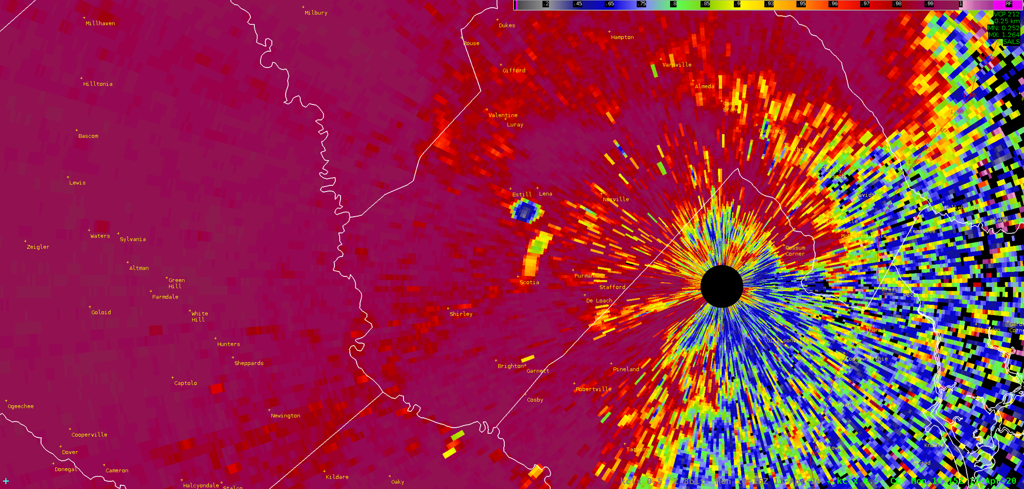
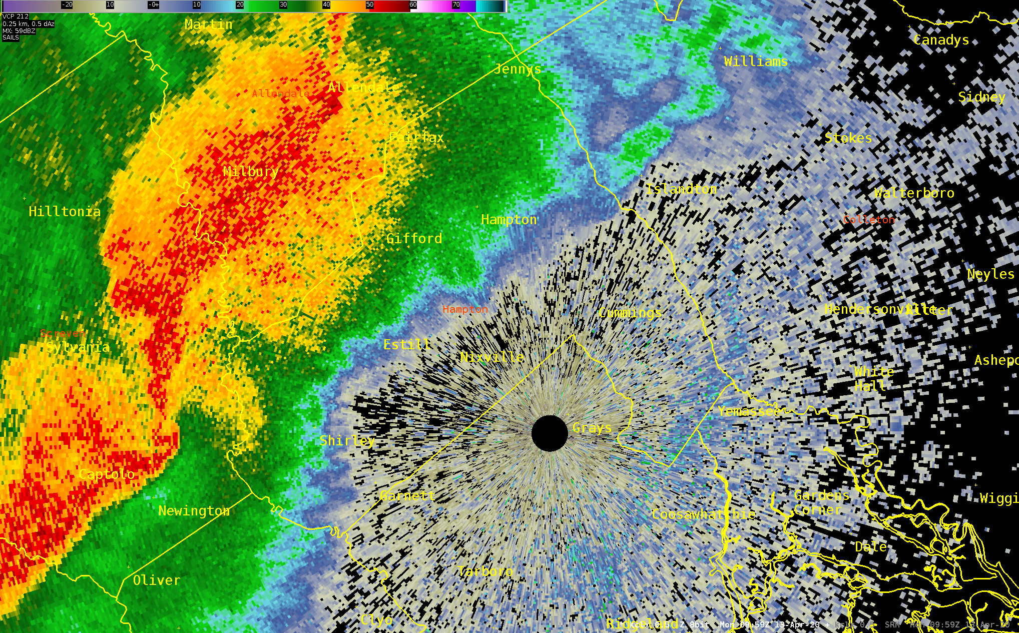
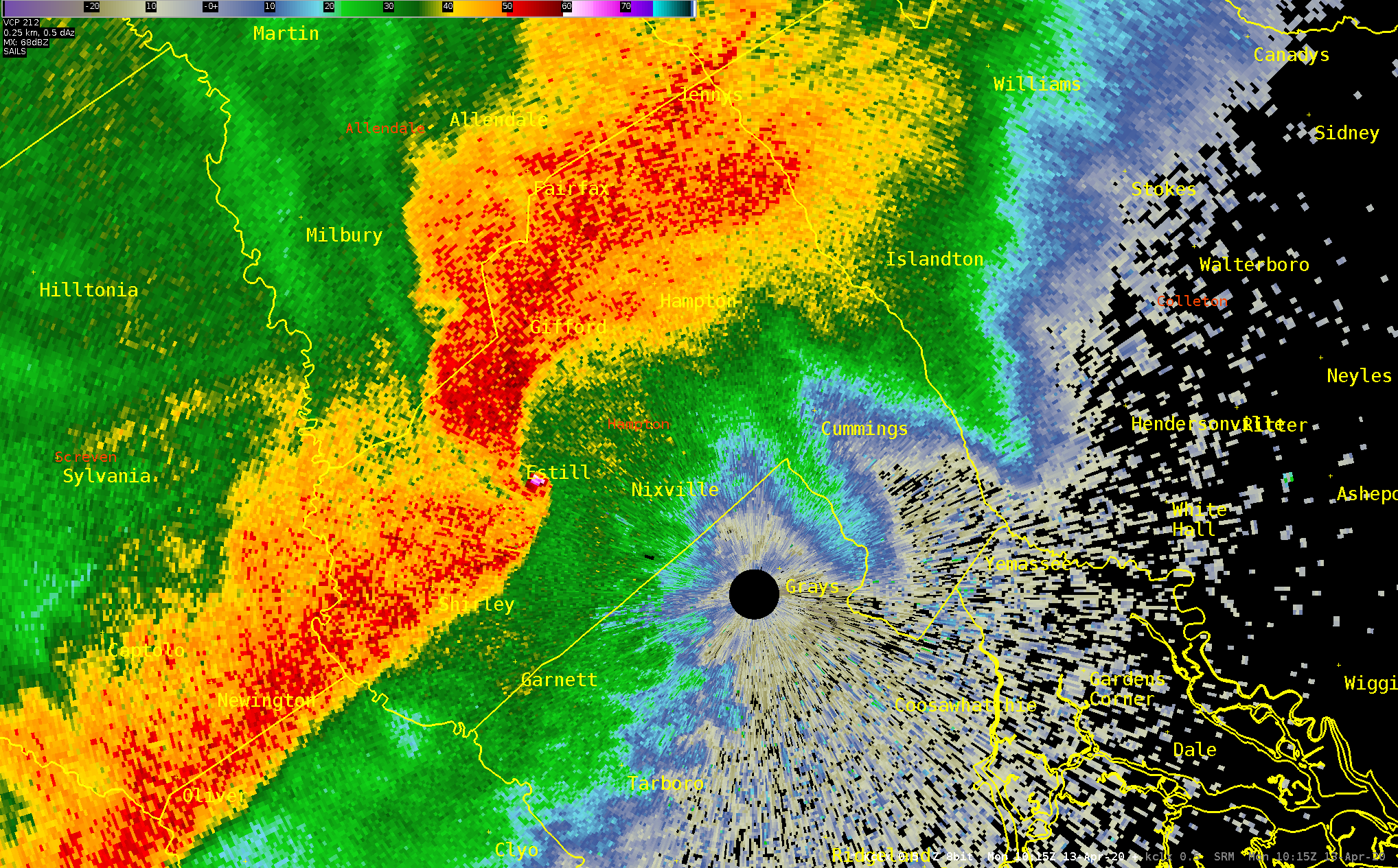
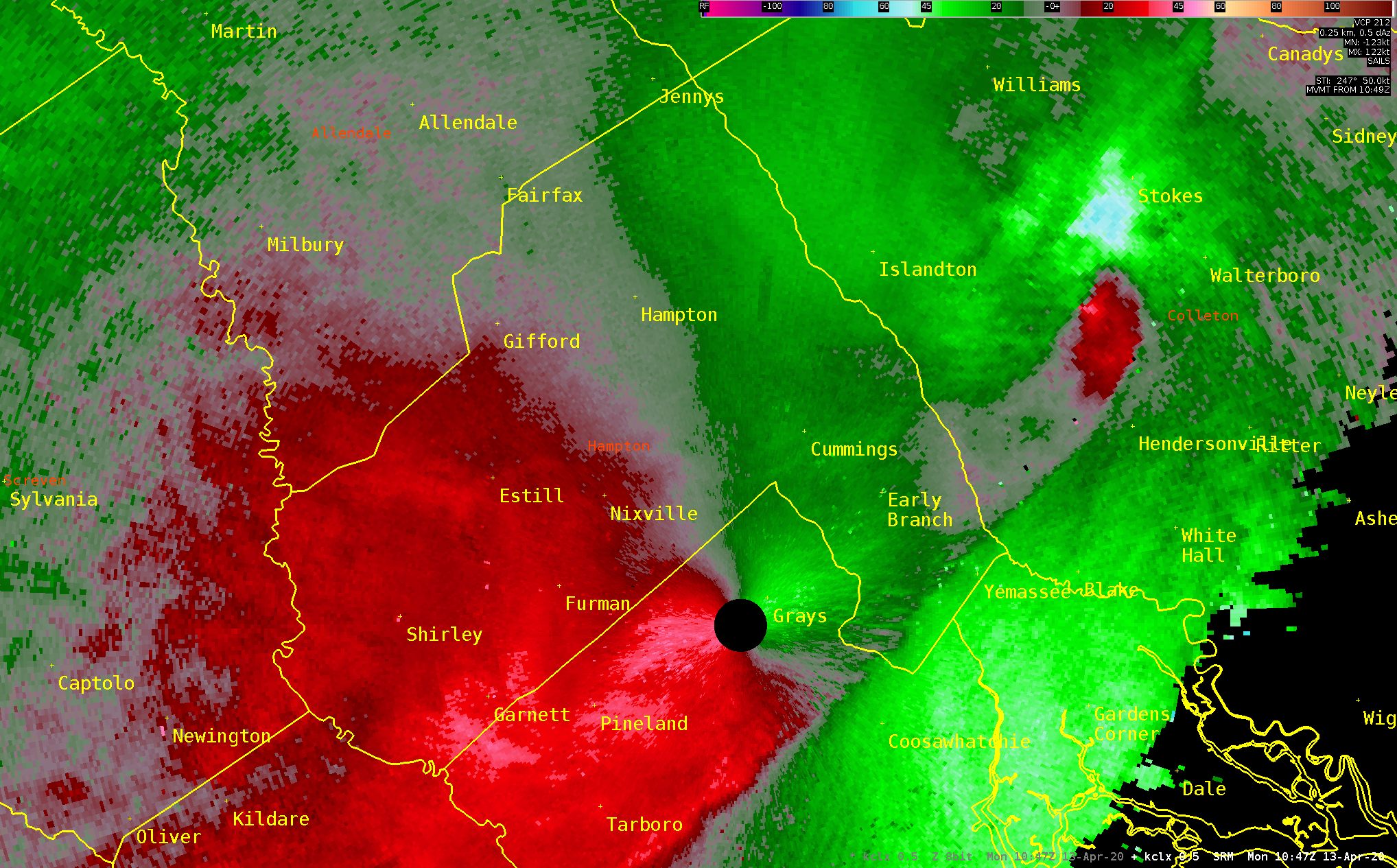
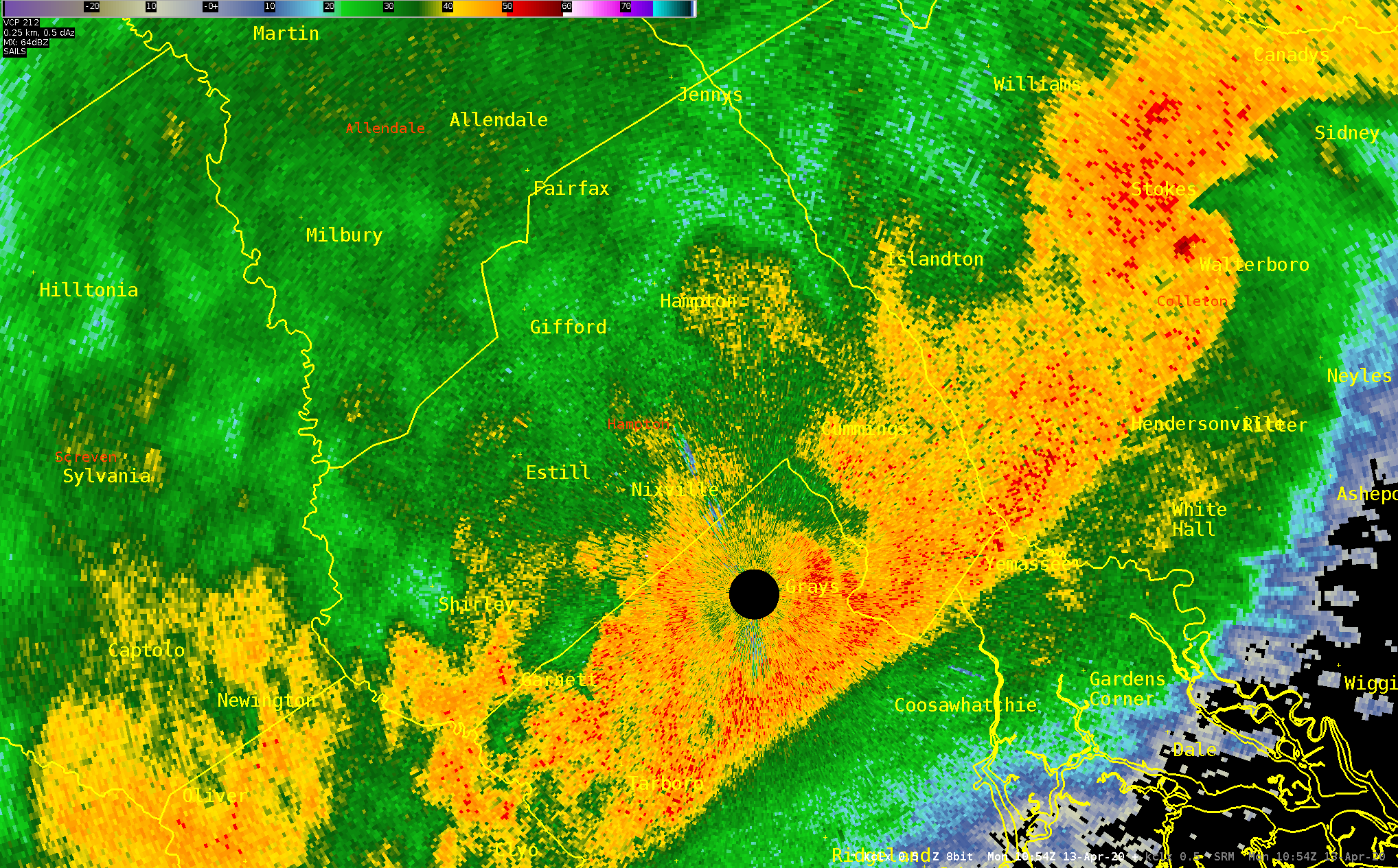
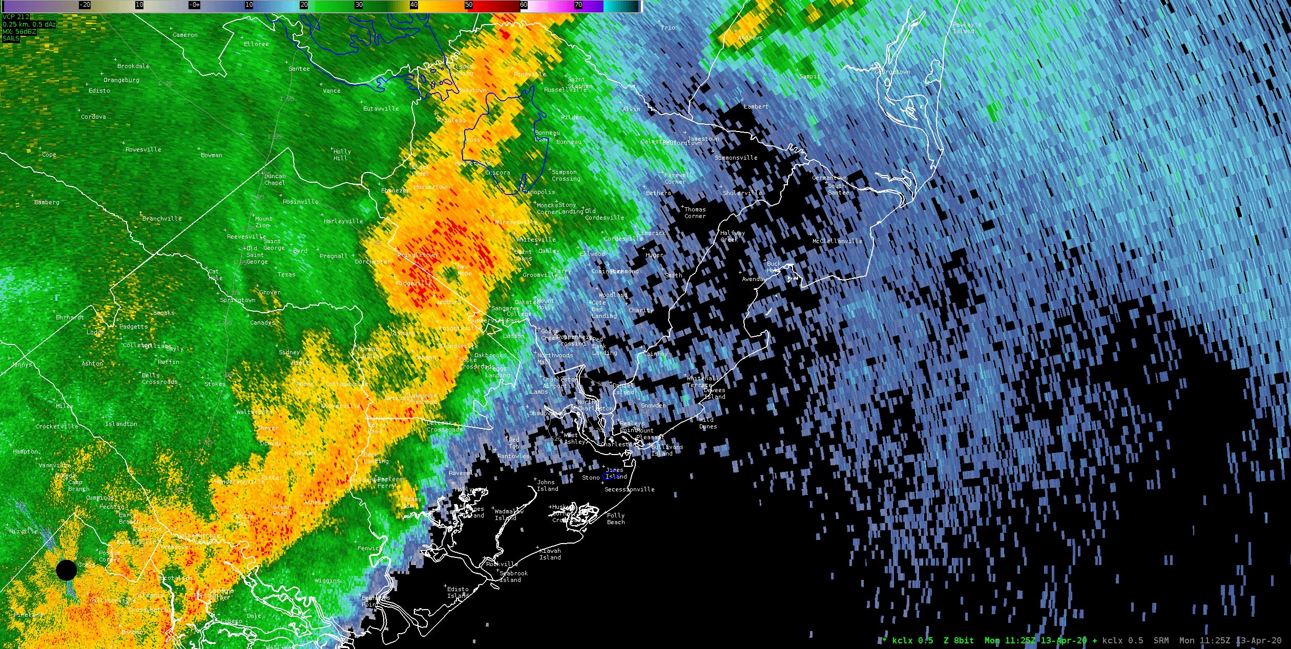
| EF4 Tornado in Hampton County, SC | ||||||
| Start Time | Max EF-Scale Rating | Max Wind Speed | Max Path Width | Path Length | Fatalities | Injuries |
|---|---|---|---|---|---|---|
| 6:10 AM EDT | EF4 | 175 mph | 1300 yards | 24.04 mi | 5 | 60 |
|
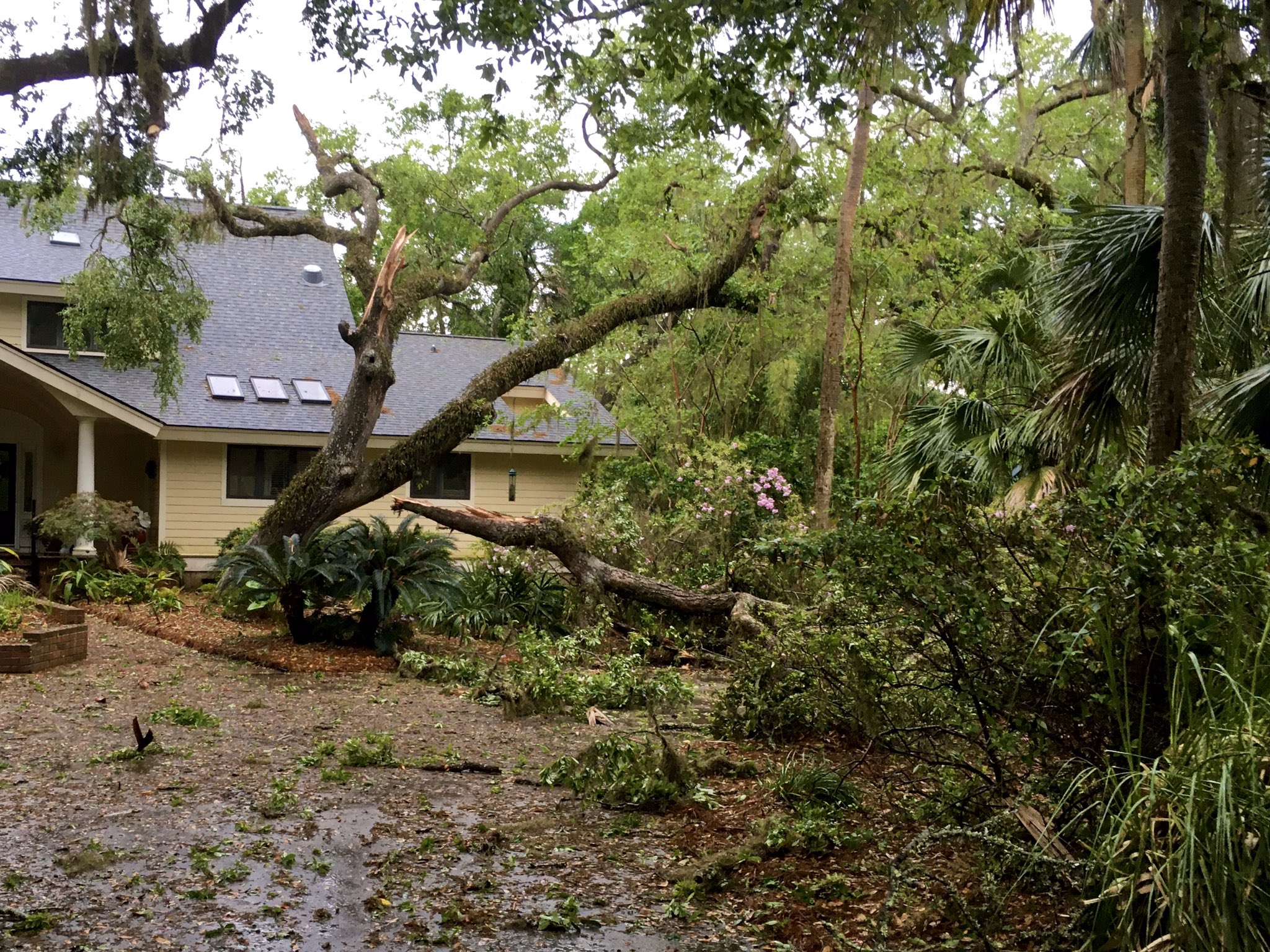
This unusually long track and wide tornado damaged and destroyed many residences, including mobile and single family homes. In addition, the tornado, which reached a maximum width of about 0.75 mile, caused extensive damage to trees and powerlines along its path, which stretched more than 24 miles from southwest of Estill, to near the Colleton County line. The most significant structural damage occurred just south of Estill and across Nixville. At least six residences were destroyed in the hardest hit areas, but there were many others that sustained various levels of damage along the entire path. The tornado strengthened shortly after |
||||||
Radar Images (click to enlarge) |
||||||
|
KCLX 0.5 Degree Reflectivity (Z) (4/13/20 - 615 AM EDT) |
KCLX 0.5 Degree Storm-relative Velocity (SRM) (4/13/20 - 615 AM EDT) |
KCLX 0.5 Degree Correlation Coefficient (CC) (4/13/20 - 615 AM EDT) |
||||
|
|
|
 |
||||
Damage Pictures (courtesy of NWS Charleston - click to enlarge) |
||||||
| EF1 Tornado in Colleton County, SC | ||||||
| Start Time | Max EF-Scale Rating | Max Wind Speed | Max Path Width | Path Length | Fatalities | Injuries |
|---|---|---|---|---|---|---|
| 6:39 AM EDT | EF1 | 90 mph | 50 yards | 1.43 mi | 0 | 0 |
|
The tornado formed just west of Route 21 in southwest Colleton County and traveled about 1.5 miles northeast before dissipating. The tornado snapped of a couple dozen pine trees and broke off some tree branches along the path. |
||||||
Radar Images (click to enlarge) |
||||||
|
KCLX 0.5 Degree Reflectivity (Z) (4/13/20 - 640 AM EDT) |
KCLX 0.5 Degree Storm-relative Velocity (SRM) (4/13/20 - 640 AM EDT) |
|||||
|
|
|
|||||
| EF1 Tornado in Colleton County, SC | ||||||
| Start Time | Max EF-Scale Rating | Max Wind Speed | Max Path Width | Path Length | Fatalities | Injuries |
|---|---|---|---|---|---|---|
| 6:46 AM EDT | EF1 | 105 mph | 100 yards | 3.16 mi | 0 | 0 |
|
The tornado formed along Route 63 west of Interstate 95 and traveled northeast a little over 3 miles before dissipating in or near the Ashepoo River/Jones Swamp area just west of Interstate 95. The tornado produced extensive tree damage in the vicinity of Beach Road. The tornado overturned a tractor trailer near mile marker 55 on Interstate 95. Hundreds of trees were snapped off or uprooted along the path. |
||||||
Radar Images (click to enlarge) |
||||||
|
KCLX 0.5 Degree Reflectivity (Z) (4/13/20 - 647 AM EDT) |
KCLX 0.5 Degree Storm-relative Velocity (SRM) (4/13/20 - 647 AM EDT) |
|||||
|
|
|
|||||
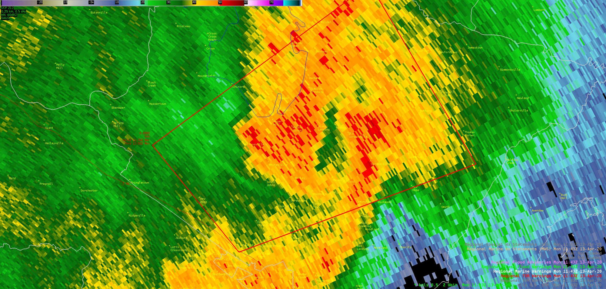
| EF1 Tornado in Colleton County, SC (Walterboro) | ||||||
| Start Time | Max EF-Scale Rating | Max Wind Speed | Max Path Width | Path Length | Fatalities | Injuries |
|---|---|---|---|---|---|---|
| 6:47 AM EDT | EF1 | 110 mph | 500 yards | 17.4 mi | 1 | 1 |
|
The tornado formed near Route 63 about a mile east of the West Walterboro tornado. This tornado grew in size as it tracked through Walterboro and then tracked northeastward through the Low Country Regional Airport and then further northeast with a preliminary length of about 8 miles. Further investigation needs to be done to determine if the path continued farther to the northeast and if so how far. This tornado produced extensive tree damage along the path across northwestern portions of Walterboro with many hundreds of trees snapped off or uprooted. Trees falling on houses or the wind associated with the tornado produced mainly minor damage to hundreds of residences and some businesses. Inflow winds into the tornado produced significant tree and some structural damage across the central and southeastern portions of Walterboro. In this area a large pine tree fell through a section of a home killing a person and injuring another. At the Low Country Regional Airport, winds associated with the tornado or winds flowing into the tornado damaged or destroyed most hangers and damaged or destroyed nearly two dozen aircraft. The tornado continued east-northeastward, sporadically touching down just north of Route 17-A, between Sidneys Road to Red Oak Road, just northeast of Cottageville. The damage was mainly snapping and uprooting of trees. |
||||||
Radar Images (click to enlarge) |
||||||
|
KCLX 0.5 Degree Reflectivity (Z) (4/13/20 - 654 AM EDT) |
KCLX 0.5 Degree Storm-relative Velocity (SRM) (4/13/20 - 654 AM EDT) |
KCLX 0.5 Degree Correlation Coefficient (CC) (4/13/20 - 654 AM EDT) |
||||
|
|
|
 |
||||
Damage Pictures (courtesy of NWS Charleston - click to enlarge) |
||||||
| EF1 Tornado in Dorchester County, SC | ||||||
| Start Time | Max EF-Scale Rating | Max Wind Speed | Max Path Width | Path Length | Fatalities | Injuries |
|---|---|---|---|---|---|---|
| 7:10 AM EDT | EF1 | 102 mph | 150 yards | 2.29 mi | 0 | 0 |
|
The tornado touched down near Route 61, south of Givhans Ferry State Park, and moved northeast, dissipating just northeast of the intersection of Carter Road and Queen Drive. Along this path were many sporadic snapped/uprooted trees. Near the end of the path at a residence near Carter Road, a two ton wood crate container was lifted and overturned. There was significant straight line wind damage to trees just south of this path, along and north of Campbell Road. |
||||||
Damage Pictures (courtesy of NWS Charleston - click to enlarge) |
||||||
| EF1 Tornado in Long County, GA | ||||||
| Start Time | Max EF-Scale Rating | Max Wind Speed | Max Path Width | Path Length | Fatalities | Injuries |
|---|---|---|---|---|---|---|
| 7:37 AM EDT | EF1 | 105 mph | 500 yards | 3.21 mi | 0 | 0 |
|
The path of this tornado was originally detected by high resolution satellite imagery over the remote area of the Griffin Ridge Wildlife Management Area (WMA), located just southwest of Ludowici. It was confirmed on the ground using damage pictures sent by staff from the Georgia Department of Natural Resources at Griffin Ridge WMA. The tornado began near Hughes River Road, about 5.5 miles southwest of Ludowici and about 3 miles west of Highway 301. The tornado then moved east-northeast over mostly marsh and uninhabited area, crossing over Check Station Road which enters into the Griffin Ridge WMA off of Highway 301. The tornado then ended just east-northeast of Check Station Road, and just west of Highway 301. The impact of this tornado was snapping and uprooting of many trees along and near the path. |
||||||
Damage Pictures (courtesy of NWS Charleston - click to enlarge) |
||||||
| EF3 Tornado in Berkeley County, SC (near Moncks Corner) | ||||||
| Start Time | Max EF-Scale Rating | Max Wind Speed | Max Path Width | Path Length | Fatalities | Injuries |
|---|---|---|---|---|---|---|
| 7:38 AM EDT | EF3 | 145 mph | 0.5 mi | 5.81 mi | 0 | 6 |
|
The tornado began in the Fairlawn Subdivision, just east of Moncks Corner. Several homes had significant damage along Old Fort Road and Dennis Blvd. There was a home at the east end of Dennis Blvd that had significant enough damage to justify an EF3 rating. There was also extensive snapping and uprooting of trees, as well as vehicle and trailer damage in the area. The tornado moved east-southeast, generally down Dennis Blvd, eastward across the west branch of the Cooper River, and then east-northeastward across SC-402 and Cane Gully Road. At this location, a mobile home was completely destroyed, several other homes and structures sustained significant damage. The tornado continued east-northeastward snapping and uprooting trees, with significant damage to at least one home off of Myrtle Lane, and minor roof and siding damage to approximately four additional homes just south of Bullhead Road. The tornado then dissipated near the intersection of Myrtle Lane and Wright Road. This tornado was part of a family of tornadoes that began more than 100 miles to the southwest, in Screven County, GA. |
||||||
Radar Images (click to enlarge) |
||||||
|
KCLX 0.5 Degree Reflectivity (Z) (4/13/20 - 743 AM EDT) |
KCLX 0.5 Degree Storm-relative Velocity (SRM) (4/13/20 - 743 AM EDT) |
|||||
|
|
|
|||||
Damage Pictures (courtesy of NWS Charleston - click to enlarge) |
||||||
| EF0 Tornado in Long County, GA | ||||||
| Start Time | Max EF-Scale Rating | Max Wind Speed | Max Path Width | Path Length | Fatalities | Injuries |
|---|---|---|---|---|---|---|
| 7:47 AM EDT | EF0 | 100 mph | 100 yards | 0.36 mi | 0 | 0 |
|
This tornado had a very brief touchdown just east of Ludowici, downing and uprooting a few trees and causing damage to two barn buildings and mobile home near Stafford Diary Road. |
||||||
| EF0 Tornado in Berkeley County, SC | ||||||
| Start Time | Max EF-Scale Rating | Max Wind Speed | Max Path Width | Path Length | Fatalities | Injuries |
|---|---|---|---|---|---|---|
| 7:51 AM EDT | EF0 | 85 mph | 200 yards | 0.93 mi | 0 | 0 |
|
The weak tornado began just south of Lem Road, then moved north-northeastward across Lem and Bethera Roads, dissipating just northwest of Bethera. The tornado snapped and uprooted multiple trees along the path, and at least one home along Witherbee Road had a limb blown onto the roof. |
||||||
Damage Pictures (courtesy of NWS Charleston - click to enlarge) |
||||||
| EF1 Tornado in Berkeley County, SC | ||||||
| Start Time | Max EF-Scale Rating | Max Wind Speed | Max Path Width | Path Length | Fatalities | Injuries |
|---|---|---|---|---|---|---|
| 8:00 AM EDT | EF1 | 108 mph | 400 yards | 2.54 mi | 0 | 0 |
|
This brief tornado touched down just south of French Santee Road near Redding Lane. The tornado tracked northeastward across French Santee Road near Benjys Trail, dissipating about a mile northeast of the intersection of Guilliard Lake Road and Forest Road 269 in a heavily wooded area. Many trees were snapped and uprooted along the path, with some minor roof damage to one home at thecorner of French Santee Road and Benjys Trail. |
||||||
Damage Pictures (courtesy of NWS Charleston - click to enlarge) |
||||||
| EF1 Tornado in Liberty/Bryan County, GA | ||||||
| Start Time | Max EF-Scale Rating | Max Wind Speed | Max Path Width | Path Length | Fatalities | Injuries |
|---|---|---|---|---|---|---|
| 8:11 AM EDT | EF1 | 100 mph | 250 yards | 8.93 mi | 0 | 0 |
|
This tornado began near Dorchester Village Road, just east of I-95. It tracked east-northeast across Sunbury Road, then across the Medway river into southern Bryan county. In Bryan county, it crossed Route 44, and dissipated just east of Belle Island Road. A few homes and church sustained roof damage between Dorchester Village Road and Islands Highway. Otherwise, there was sporadic snapping and uprooting of trees along the path. |
||||||
Damage Pictures (courtesy of NWS Charleston - click to enlarge) |
||||||
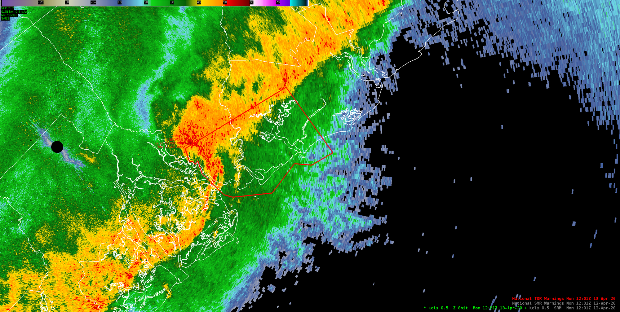
| EF2 Tornado in Colleton County, SC (Edisto Beach) | ||||||
| Start Time | Max EF-Scale Rating | Max Wind Speed | Max Path Width | Path Length | Fatalities | Injuries |
|---|---|---|---|---|---|---|
| 8:15 AM EDT | EF2 | 125 mph | 140 yards | 1.16 mi | 0 | 0 |
|
The tornado likely started as a waterspout off the coast and then moved inland across Edisto Beach. The tornado ripped portions or large sections of roofs off of six homes. The home most impacted by the storm was on the beach in the the 3300 block of Palmetto Blvd where glass doors and windows were broken in and large sections of the roof were removed. The wall facing the road of the home was pushed towards the road. There was numerous trees snapped off and uprooted along the path, power lines were knocked down, a boat and several vehicles were damaged, and a trailer was flipped over. Numerous homes had windows blown out or suffered minor siding or roof damage. The tornado dissipated around 817 AM in the marsh after leaving Edisto Beach. |
||||||
Radar Images (click to enlarge) |
||||||
|
KCLX 0.5 Degree Reflectivity (Z) (4/13/20 - 801 AM EDT) |
KCLX 0.5 Degree Storm-relative Velocity (SRM) (4/13/20 - 816 AM EDT) |
KCLX 0.5 Degree Correlation Coefficient (CC) (4/13/20 - 820 AM EDT) |
||||
|
|
|
|
||||
Damage Pictures (courtesy of NWS Charleston - click to enlarge) |
||||||
 |
||||||
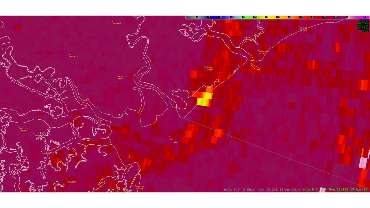
| EF1 Tornado in Charleston County, SC (Seabrook Island) | ||||||
| Start Time | Max EF-Scale Rating | Max Wind Speed | Max Path Width | Path Length | Fatalities | Injuries |
|---|---|---|---|---|---|---|
| 8:28 AM EDT | EF1 | 105 mph | 120 yards | 1.25 mi | 0 | 0 |
|
The same storm that produced a tornado at Edisto Beach also produced a tornado on Seabrook Island. This tornado developed in the southwest portion of Seabrook Island west of the intersection of Seabrook Island Road and Camp Christopher Lane. The tornado traveled northeast about 1.25 miles while snapping off or uprooting dozens of trees and breaking off numerous large branches. A garage was significantly damaged when a large tree fell on it. Several other homes sustained minor damage due to trees falling near homes or large branches falling on homes. The most significant damage occurred on or near the golf course. The tornado dissipated just northeast of the intersection of Seabrook Island Road and The Lookout Road. |
||||||
Radar Images (click to enlarge) |
||||||
|
KCLX 0.5 Degree Reflectivity (Z) (4/13/20 - 829 AM EDT) |
KCLX 0.5 Degree Storm-relative Velocity (SRM) (4/13/20 - 826 AM EDT) |
|||||
|
|
|
|||||
Damage Pictures (courtesy of NWS Charleston - click to enlarge) |
||||||
| EF1 Tornado in Charleston County, SC (Kiawah Island) | ||||||
| Start Time | Max EF-Scale Rating | Max Wind Speed | Max Path Width | Path Length | Fatalities | Injuries |
|---|---|---|---|---|---|---|
| 8:33 AM EDT | EF1 | 105 mph | 60 yards | 0.3 mi | 0 | 0 |
|
The same storm that produced a tornado at Edisto Beach and another on Seabrook Island produced a third tornado on Kiawah Island. The tornado developed near the 12th hole of a golf course and traveled east-northeast down the fairway and into a residential neighborhood before dissipating just east of Green Winged Teal Road. Evidence of the tornado was clearly seen on both sides of the fairway. Several large trees were snapped off or had large branches broken off. |
||||||
Damage Pictures (courtesy of NWS Charleston - click to enlarge) |
||||||


Event Review (SC State Climate Office)
Historical SC/NE GA Tornadoes (NWS Greenville-Spartanburg)
Timber Impacts in SC from the Tornadoes (SC Forestry Commission)


 Coastal Flood