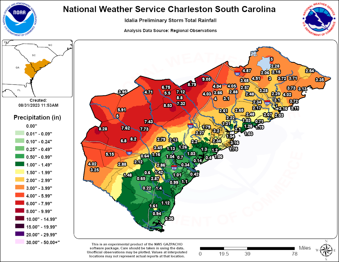
List of Idalia's Storm Total Rainfall: Link
Click the tornado icon on the map to display the damage survey summary and on the tornado track for tornado details.

 |
 |
 |
 |
 |
| EF0 | EF1 | EF2 | EF3 | EF4 |
| EF0 Tornado in Fleming, GA (Liberty County) | |||||||
| Start Time | End Time | Max EF-Scale Rating | Max Wind Speed | Max Path Width | Path Length | Fatalities | Injuries |
|---|---|---|---|---|---|---|---|
| 10:00 AM EDT | 10:03 AM EDT | EF0 | 85 mph | 100 Yards | 0.53 miles | 0 | 0 |
|
A weak, brief tornado touched down about 0.5 miles east-southeast of Mt. Olive Church Road in a very rural area. The tornado moved rapidly toward the northwest, ending just west of Mt. Olive Church Road. Along its very short path, it snapped the top of at least one pine tree, uprooted at least one other tree, broke some small to medium branches, and destroyed a small wood shed. The storm damage survey was performed by the Liberty County, GA Emergency Management Agency. |
|||||||
| EF0 Tornado in Goose Creek, SC (Berkeley County) | |||||||
| Start Time | End Time | Max EF-Scale Rating | Max Wind Speed | Max Path Width | Path Length | Fatalities | Injuries |
|---|---|---|---|---|---|---|---|
| 12:22 PM EDT | 12:23 PM EDT | EF0 | 75 mph | 50 Yards | 0.03 miles | 0 | 2 |
|
A very brief, weak tornado touched down near the intersection of Camelot Dr. and S. Goose Creek Blvd. During its brief touchdown, it flipped one car on S. Goose Creek Blvd. Police reported that two people were transported to the hospital for minor injuries. This tornado was within an outer rain band of Hurricane Idalia. A video was used to confirm the tornado. |
|||||||
| EF0 Tornado in Mount Pleasant (Charleston County) | |||||||
| Start Time | End Time | Max EF-Scale Rating | Max Wind Speed | Max Path Width | Path Length | Fatalities | Injuries |
|---|---|---|---|---|---|---|---|
| 3:30 PM EDT | 3:33 PM EDT | EF0 | 85 mph | 100 Yards | 2.74 miles | 0 | 0 |
|
A tornado, which developed within the outer bands of Hurricane Idalia, began just south of highway 17, in the Whitehall Terrace Community of Mount Pleasant. In this area it caused some minor roof damage to at least one home and uprooted several trees. The tornado then crossed highway 17, where it was presumed to have periodically touched the ground as it crossed over the Wando High School area, causing no discernible damage. As the tornado continued northward into the Carolina Park Community, it caused generally minor damage, snapping some trees and limbs, lifting one porta potty and pushing one car into a tree. The tornado then moved into the northeastern portion of the Park West Community, just south of the Wando River. In this area there was more concentrated damage, where it snapped and uprooted several trees. The tornado then seemed to dissipate as it moved toward the marsh and the Wando River. |
|||||||
| EF1 Tornado near Huger, SC (Berkeley County) | |||||||
| Start Time | End Time | Max EF-Scale Rating | Max Wind Speed | Max Path Width | Path Length | Fatalities | Injuries |
|---|---|---|---|---|---|---|---|
| 4:59 PM EDT | 5:04 PM EDT | EF1 | 95 mph | 100 Yards | 1.89 miles | 0 | 0 |
|
A tornado, associated with the outer rain bands of Hurricane Idalia, touched down just south of Eccles Church Road, over Muddy Creek. As the tornado approached Eccles Church Road, it snapped and uprooted several large hard and softwood trees. The tornado continued north-northwest into a heavily wooded area where it sporadically snapped and uprooted many more trees. The tornado continued north-northwestward over a wooded, marshy region producing more minor damage to some trees before ending near Irishtown Road. In addition to the ground survey, high resolution satellite imagery was also used to fine tune the track of the tornado.
|
|||||||
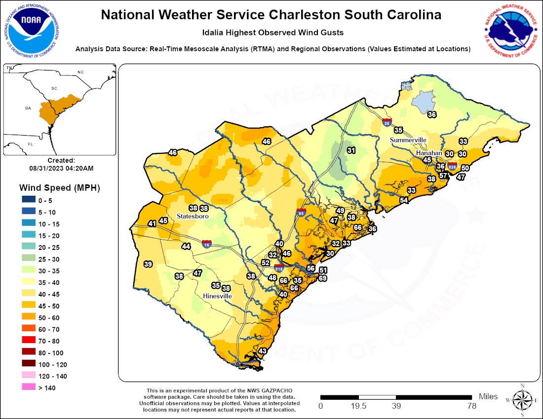
List of Idalia's Highest Observed Wind Gusts: Link
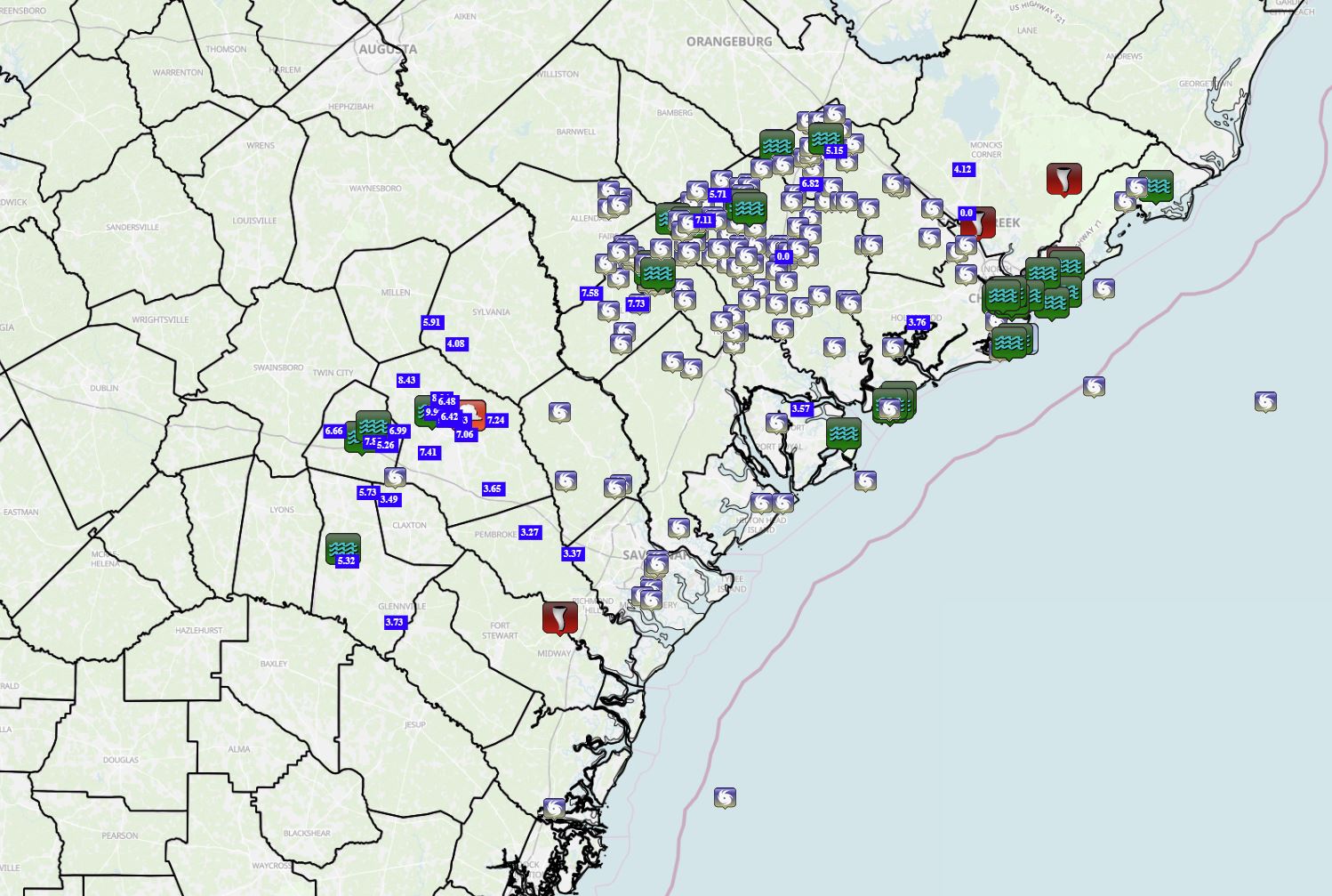
Collection of storm reports from across southeast Georgia and South Carolina: Link


 Coastal Flood