 |
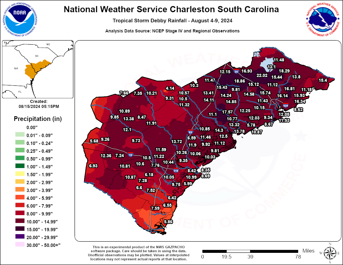
Tropical Storm Debby - Storm Total Rainfall
Click the tornado icon on the map to display the damage survey summary and on the tornado track for tornado details.

 |
 |
 |
 |
 |
| EF0 | EF1 | EF2 | EF3 | EF4 |
|
Isle of Palms, SC Tornado - August 5, 2024 |
Rating:                 EF1
Estimated Peak Wind:    87 mph
Path Length /statute/:  0.72 miles
Path Width /maximum/:   75 yards
Fatalities:             0
Injuries:               0

Start Date:             08/06/2024
Start Time:             01:33 AM EDT
Start Location:         3 WSW Wild Dunes / Charleston County / SC
Start Lat/Lon:          32.7892 / -79.7773

End Date:               08/06/2024
End Time:               01:37 AM EDT
End Location:           3 WSW Wild Dunes / Charleston County / SC
End Lat/Lon:            32.7972 / -79.785

Survey Summary:
A brief tornado, associated with an outer rain band from Tropical
Storm Debby, moved onshore near 25th Ave where it did minor roof
damage to one house and also pulled the front door out the frame.
It continued north-northwest along 25th Ave, between Palm Blvd
and Hartnett Blvd it pulled out a few windows and snapped and
uprooted some trees. As it moved just north of Hartnett Blvd, it
removed the shingles from a portion of the roofs from a few
homes. Beyond this point, the tornado curved a bit more northwest
and snapped a few more trees and it began lifting near Waterway
Blvd and 24th Ave. The tornado continued northwest and dissipated
within the Intra Coastal Waterway. Overall, an estimated 29 homes
sustained some level of damage, either directly by the tornado or
from trees or large limbs falling on them.
The worst of the damage from #Debby on the Isle of Palms is located on 25th street, where Mayor Phillip Pounds says a water spout was around 1:30 am. Neighbors tell me they heard a loud noise, like a train, around that time. Luckily, no injuries reported. @Live5News pic.twitter.com/uU4oCQYHdM
— Blair Sabol-Live 5 News (@BlairSabolTV) August 6, 2024
|
Edisto Beach, SC Tornado - August 5, 2024 |
Rating:                 EF1
Estimated Peak Wind:    97 mph
Path Length /statute/:  2.89 miles
Path Width /maximum/:   300 yards
Fatalities:             0
Injuries:               0

Start Date:             08/05/2024
Start Time:             09:35 PM EDT
Start Location:         4 S Edisto Island /  / SC
Start Lat/Lon:          32.5023 / -80.2962

End Date:               08/05/2024
End Time:               09:45 PM EDT
End Location:           4 SW Edisto Island / Charleston County / SC
End Lat/Lon:            32.525 / -80.3376

Survey Summary:
The tornado, which originated in an outer rain band associated
with Tropical Storm Debby over the nearshore Atlantic waters,
moved onshore at Edisto Beach, near the intersection of Highway
174 and Palmetto Blvd. As the tornado moved onshore, it removed
roof decking, roof shingles and siding to several homes. The
Enmarket gas station also had some roof damage and air
conditioning units thrown from the roof. The tornado then moved
northwestward over a marsh region, snapping many hardwood trees
and uprooting numerous trees along Palmetto Road. From Palmetto
Road, the tornado continued on a northwest path crossing over
Fishing Creek Drive. At this location, the tornado did
considerable damage to several homes. It removed the entire roof
of at least three homes and part of the roof decking to at least
one more. The tornado was given its highest EF1 rating in this
area, with maximum winds estimated to be around 97 mph. Beyond
this location, the tornado continued northwest, dissipating over
the marsh region north of Palmetto Road. Note: there were likely
additional structures damaged along the path of the tornado, but
the amount of time to conduct the survey was limited.
Heavy damage to McConkey’s on Edisto Beach. Good sign: power crews giving it their all to restore power. @ABCNews4 #chswx #chsnews #TropicalStormDebby pic.twitter.com/UuJ9BzYyzd
— Jason Tighe (@jtighe08) August 7, 2024
|
South Edisto, SC Tornado - August 5, 2024 |
Rating:                 EF1
Estimated Peak Wind:    90 mph
Path Length /statute/:  0.56 miles
Path Width /maximum/:   100 yards
Fatalities:             0
Injuries:               0

Start Date:             08/05/2024
Start Time:             10:08 PM EDT
Start Location:         6 SSW Edisto Island /  / SC
Start Lat/Lon:          32.479 / -80.3307

End Date:               08/05/2024
End Time:               10:11 PM EDT
End Location:           6 SSW Edisto Island / Colleton County / SC
End Lat/Lon:            32.4844 / -80.3378

Survey Summary:
A brief tornado, associated with an outer rain band from Tropical
Storm Debby, moved onshore at the south end of Edisto Island near
the 2700 block of Point Street, where it snapped and twisted some
small trees and removed asphalt shingles to at least one home.
The worst damage was on Palmetto Blvd, where one home had a
complete collapse of the porch and a significant portion of the
roof removed.  The tornado continued to move rapidly
northwestward crossing around the 2700 block of Myrtle Street,
where it did some minor damage to the facia of at least one home.
Just northwest, near the 2900 block of Lee Street, at least one
home had a corner of the roof removed. The tornado then moved
into the southern portion of the Plantation Golf Course where it
dissipated.
Caught this person driving pretty much full speed into a downed tree last night after the Edisto Beach tornado ... Checked on them and they were all okay. pic.twitter.com/ztQnwr4TCn
— Bryce Shelton (@BryceShelton01) August 7, 2024
|
Kiawah Island, SC Tornado - August 5, 2024 |
Rating:                 EF0
Estimated Peak Wind:    85 mph
Path Length /statute/:  1.18 miles
Path Width /maximum/:   150 yards
Fatalities:             0
Injuries:               0

Start Date:             08/05/2024
Start Time:             10:55 PM EDT
Start Location:         1 ESE Kiawah Island /  / SC
Start Lat/Lon:          32.6035 / -80.074

End Date:               08/05/2024
End Time:               10:59 PM EDT
End Location:           1 NNW Kiawah Island / Charleston County / SC
End Lat/Lon:            32.6168 / -80.0866

Survey Summary:
A tornado, associated with an outer rain band of Tropical Storm
Debby, moved onshore around the 30 to 40 block area of Surfsong
Road on Kiawah Island. No significant damage was detected at the
point it came onshore. The tornado moved rapidly northwestward
through the center of Turtle Point Golf course and snapped some
trees and limbs around the 270 to 280 block region on Doral Open
Road. The tornado continued northward toward the 25 to 30 block
of Governors Drive, where it snapped and uprooted some trees. The
tornado then moved northwest, and dissipated over the marsh
region between Governors Drive and Rhetts Bluff Road.
More damage on Kiawah…📍Burroughs Hall of governors dr @NWSCharlestonSC pic.twitter.com/OI58v6F6Oc
— Jed Christoph (@JedChristophWX) August 6, 2024
|
West Ashley, SC Tornado - August 6, 2024 |
Rating:                 EF0
Estimated Peak Wind:    77 mph
Path Length /statute/:  3.88 miles
Path Width /maximum/:   200 yards
Fatalities:             0
Injuries:               0

Start Date:             08/06/2024
Start Time:             12:14 AM EDT
Start Location:         Citadel Mall / Charleston County / SC
Start Lat/Lon:          32.8 / -80.035

End Date:               08/06/2024
End Time:               12:22 AM EDT
End Location:           Shadowmoss / Charleston County / SC
End Lat/Lon:            32.8432 / -80.0765

Survey Summary:
A tornado, associated with an outer band from Tropical Storm
Debby, began near the Citadel Mall and I-526, where small limb
debris found across I-526. The tornado is suspected to have
sporadically touched down as it continued northwest across a
mostly uninhabited area along Henry Tecklenburg Dr, just south of
Bon Secours St. Francis Hospital. It then continued northwest
across Glenn McConnell Pkwy where it snapped and uprooted some
trees as it move near Bairds Cv and Mary Ader Ave.  The tornado
then crossed a marshy area of Long Branch Creek, and snapped and
uprooted a few more trees around Wicklowe Drive. It continued
northwest, south of Canterbury Woods over a heavily wooded area,
and crossed Bees Ferry Road. The tornado then tracked down the
southern end of Shadowmoss Plantation Golf  Club, where it
snapped and uprooted a few more trees between Brogun Ln,
McDougall Dr and Dunvegan Dr. The tornado dissipated just south
of Mulrfield Pkwy, just northwest of the Shadowmoss clubhouse.
|
St. Helena Island, SC Tornado - August 6, 2024 |
Rating:                 EF0
Estimated Peak Wind:    74 mph
Path Length /statute/:  0.85 miles
Path Width /maximum/:   60 yards
Fatalities:             0
Injuries:               0

Start Date:             08/06/2024
Start Time:             12:41 AM EDT
Start Location:         3 ESE Frogmore / Beaufort County / SC
Start Lat/Lon:          32.3736 / -80.5253

End Date:               08/06/2024
End Time:               12:43 AM EDT
End Location:           2 ESE Frogmore / Beaufort County / SC
End Lat/Lon:            32.3819 / -80.5361

Survey Summary:
A weak, very short-lived tornado associated with an outer rain
band of Tropical Storm Debby touched down over the marsh region
of the Harbor River, just south of 1st Coleman Road. Note: Radar
data was used to estimate the beginning of the tornado path over
the remote marsh region south of 1st Coleman Road. The first
detectable damage was a small uprooted tree and a few snapped
tree limbs near the southern end of 1st Coleman Road, where it
borders the marsh region of the Harbor River. The tornado moved
rapidly northwest, generally along the southern and western side
of 1st Coleman Road where it snapped several tree limbs and small
trees, broke a flag pole at the base, and did minor damage to the
metal skirt at the base of one mobile home. The tornado continued
briefly to the northwest where it ended in a heavily wooded area
just southwest of the intersection of Seaside Road and 1st
Coleman Road. Thanks to the Emergency Management Division of the
Beaufort County Sheriff`s office for their assistance with the
ground survey of this event.
|
Lady's Island, SC Tornado - August 6, 2024 |
Rating:                 EF0
Estimated Peak Wind:    85 mph
Path Length /statute/:  2.14 miles
Path Width /maximum/:   60 yards
Fatalities:             0
Injuries:               0

Start Date:             08/06/2024
Start Time:             12:53 AM EDT
Start Location:         1 ESE Ashdale / Beaufort County / SC
Start Lat/Lon:          32.4393 / -80.6085

End Date:               08/06/2024
End Time:               12:56 AM EDT
End Location:           1 WNW Ashdale / Beaufort County / SC
End Lat/Lon:            32.4578 / -80.638

Survey Summary:
A short lived, high end EF0 tornado developed in an outer rain
band of Tropical Storm Debby over Point Creek, just southeast of
Lady`s Island. The tornado moved rapidly northwest across a
Marshy region of the island, and when it reached Holly Hall Road,
it snapped several small trees in an uninhabited area. The
tornado continued northwest across the marsh region of Rock
Springs Creek, ending around the 500 block of Sams Point Road,
where it snapped several more trees. Continuing on a northwest
path, the tornado then quickly dissipated just south of Wade
Hampton Drive.
Tree damage, structures damaged, vehicle damage - location correlates with debris signature on radar from 12:59am. Powerflashes were observed.

Coordinates: 32.4567929, -80.6366430

Address - 495-497 Sams Point Rd, Beaufort, SC 29907@NWSCharlestonSC @bftcountysc #Debby #SCwx pic.twitter.com/hVX6UR14YS
— Ben McHone (@Tornado_Warned) August 6, 2024
|
Moncks Corner, SC Tornado - August 6, 2024 |
Rating:                 EF1
Estimated Peak Wind:    95 mph
Path Length /statute/:  3.88 miles
Path Width /maximum/:   150 yards
Fatalities:             0
Injuries:               0

Start Date:             08/06/2024
Start Time:             02:53 AM EDT
Start Location:         1 NW Stony Landing / Berkeley County / SC
Start Lat/Lon:          33.2079 / -79.9807

End Date:               08/06/2024
End Time:               03:00 AM EDT
End Location:           1 SSW Wampee / Berkeley County / SC
End Lat/Lon:            33.2369 / -80.0381

Survey Summary:
The tornado, which originated in an outer rain band associated
with Tropical Storm Debby, touched down just east of McCormick
Circle and snapped two trees in the woods just behind an
Applebees. The tornado then moved northwest, causing damage to
the Applebees sign, and then turned west and impacted the Arbys.
This was the location of the strongest damage as numerous windows
were blown out at the Arbys on both the west and east-facing
sides of the building. The rooftop A/C was also blown into the
Arbys parking lot. However, no other structural damage was
noted, and therefore the degree of damage was kept near the
middle of the expected wind speed, or at 95 mph. The Walmart
Supercenter to the northwest of Arbys also sustained some very
minor roof fascia damage, which was starting to peel off from the
main structure. After this, the tornado continued to move
northwest and passed Mitton Road, where several trees were
uprooted with a few branches greater than 3 inches diameter broken.
There was also a residence on Mitton Road that had roof damage to
less than 20% of the structure. The tornado then moved northwest
and weakened as it crossed Kitfield Rd, where some branches
(mostly 1 to 3 inches in diameter) were observed broken. To the
northwest on Lois Circle and Broughton Rd, branches that were
snapped (1 to 3 inches in diameter) were noted. Finally, the tornado
moved to the northwest, and dissipated on the northern end of the
Pinopolis peninsula on the south end of Lake Moultrie.

The National Weather Service at Charleston, SC would like to thank
Berkeley County Emergency Management for their invaluable help
with various damage photos and track maps.
HAPPENING NOW/Berkeley:
— Trooper Bob (@TrooperBob_SC) August 6, 2024
First responders are on scene at a car dealership in Moncks Corner. There is an overturned car on top of another and damage in the surrounding area. @ABCNews4 @NWSCharlestonSC pic.twitter.com/76V6pgip2D
Tropical Storm Debby - Peak Wind Gust Report


 Coastal Flood