A computer system upgrade will cause limited impacts to services between April 28, 2025 and April 30, 2025 Read More >
...A STATISTICAL PREVIEW OF CARIBOU'S APRIL WEATHER...
During the month of April the average temperatures undergo the largest rise of any month of the year. The average high temperature climbs from 40 degrees on the 1st to 56 by the end of the month. The average low temperature rises from 23 on the 1st To 36 by the end of the month. The warmest temperature ever observed during the month of April was 86 degrees on April 27, 1990. The coldest temperature ever observed in April was 4 below on april 6, 2015.
An average of 7.4 inches of snow falls during the month of April. Since 1940 April snowfall has ranged from a trace in 1955 and 1968 to 36.4 inches in 1982. The greatest 24 hour snowfall observed in April was 21.1 inches in 1982. There have been 3 times during the month of April since 1940 when the monthly snowfall exceeded 2 feet. On average there are 2 days in April with a snowfall of 1 inch of more…and 1 day with a snowfall of 3 inches of more.
In most years the snow pack melts out during the first half of April…but snow may remain on the ground in wooded areas for a couple of weeks after the snow has melted in town and in open fields. On average the snow pack melts out on April 12th but in some years has been as late as early May. The greatest snow depth of 42 inches was observed on April 8, 1982. The greatest snow depth at the end of the month was 6 inches in 1961.
Thunderstorms are still a relatively rare occurrence in April. On average there is thunderstorm about once every 3 years during the month of April.
APRIL: CARIBOU’S TOP 5 WARMEST (AVERAGE TEMPERATURES):
44.9 DEGREES 2010
43.9 1987
42.8 1986
42.6 1980
41.9 1945
APRIL: CARIBOU’S TOP 5 COLDEST (AVERAGE TEMPERATURES):
29.1 DEGREES 1947
30.7 1943
32.3 2003
32.5 1944
32.9 1939
APRIL: CARIBOU’S TOP 5 WETTEST
6.19 INCHES 2005
5.26 1973
4.62 2018
4.58 2000
4.50 1951
APRIL: CARIBOU’S TOP SNOWIEST:
36.4 INCHES 1982
29.0 2007
24.4 1961
22.2 1973
16.2 1953
APRIL: CARIBOU’S TOP 5 DRIEST
0.54 INCHES 1967
0.73 1966
0.86 1955
0.92 1944
0.96 2001
…APRIL STATISTICS…
….TEMPERATURES (1981-2010 NORMALS)
AVERAGE HIGH……………………….....................................47.8
AVERAGE LOW………...........................................................29.5
MONTHLY AVERAGE…………………………………………..38.6
AVERAGE # OF DAYS W/HIGHS <32F……………………...1 (1.1)
AVERAGE # OF DAYS W/LOWS < 32F……………………..19 (19.1)
AVERAGE # OF DAYS W/HIGHS > 60F………………….…2
…PRECIPITATION…
MONTHLY AVERAGE………………………………………….....2.66 INCHES
AVERAGE DAYS WITH MEASURABLE PRECIPITATION…..13 (12.8)
LARGEST 24 HOUR RAINFALL……………………..…………..2.11 INCHES, 1958
AVERAGE SNOWFALL…………………………………………..7.4 INCHES
MOST SNOWFALL………………………………………………..36.4 INCHES, 1982
LEAST SNOWFALL……………………………………………….TRACE, 1955 & 1968
AVERAGE # OF DAYS W/SNOWFALL > 1 INCH………….….2 (2.3)
AVERAGE # OF DAYS W/SNOWFALL > 3 INCHES…………1
…MISCELLANEOUS APRIL AVERAGES…
NORMAL HEATING DEGREE DAYS………………………..…791
NORMAL COOLING DEGREE DAYS……………………….…0
MEAN WIND SPEED……………………………………………..8.9 MPH
AVERAGE NUMBER OF DAYS W/DENSE FOG…………..…2
MEAN NUMBER OF CLOUDY DAYS………………………….18
…SUNRISE AND SUNSET…
APRIL 1ST………………………………………………..………….6:11 AM/7:01 PM
APRIL 30TH .…….………………………………………….……….5:18 AM/7:41 PM
GAIN OF DAYLIGHT……………………………………….……..1 HOUR & 33 MINUTES
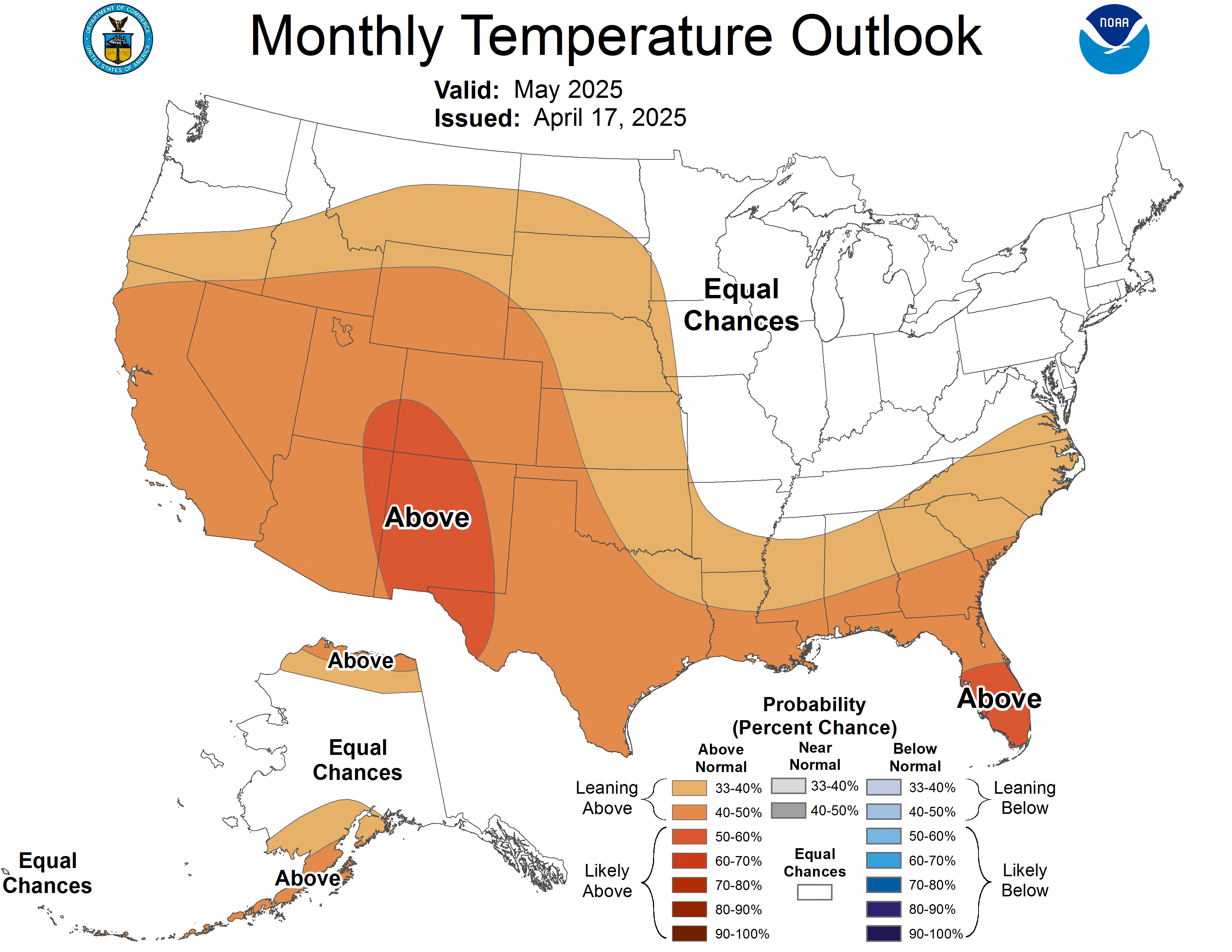
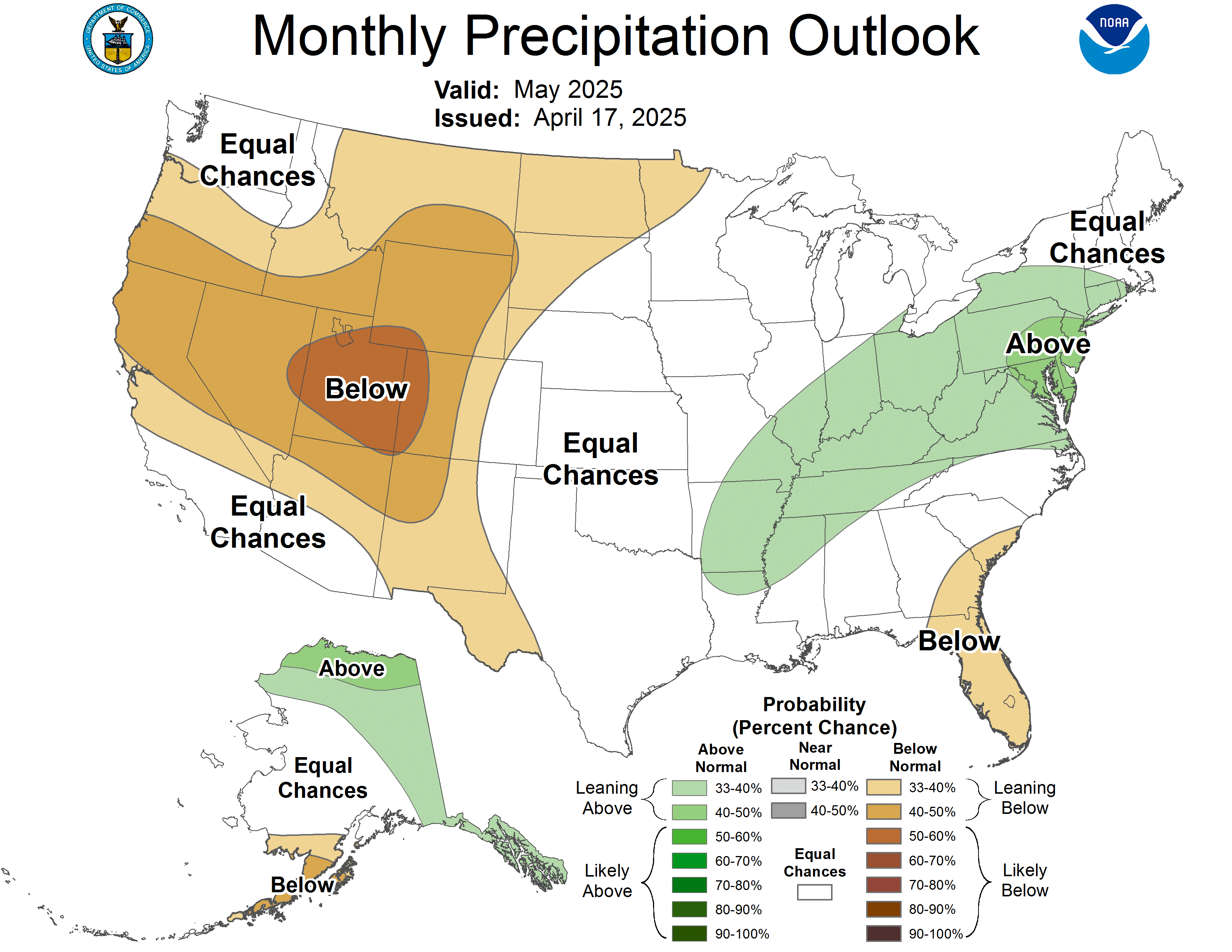
The outlook from the Climate Prediction Center for April calls for an increased chance of above average temperatures. There are currently no strong climate signals that would point toward an unusually wet or dry month.

