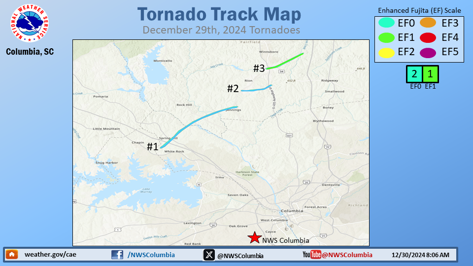
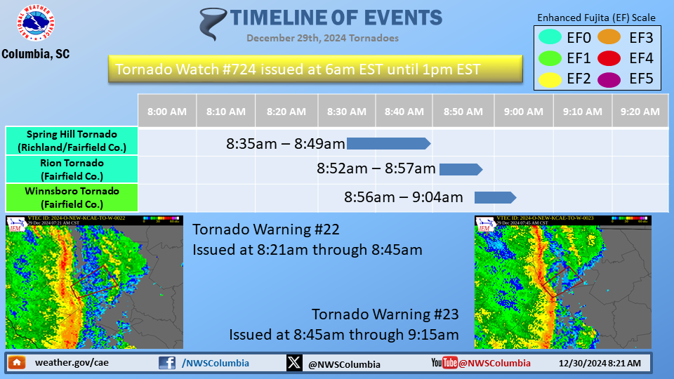
Tornadoes in the Midlands, December 29, 2024
NOUS42 KCAE 292354
PNSCAE
GAZ040-063>065-077-SCZ016-018-020>022-025>031-035-037-038-041-115-
116-135>137-301800-

Public Information Statement
National Weather Service Columbia SC
654 PM EST Sun Dec 29 2024

...NWS Damage Survey for 12/29/24 Tornado Event...

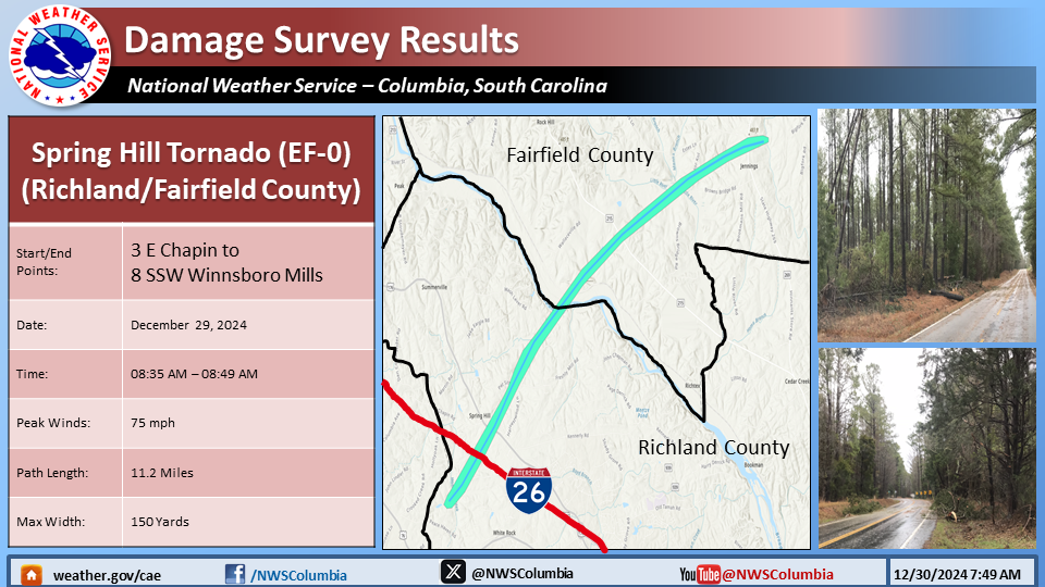
...Spring Hill, SC EF-0 Tornado in Richland and Fairfield Counties...

Rating:                 EF0
Estimated Peak Wind:    75 mph
Path Length /statute/:  11.20 miles
Path Width /maximum/:   150 yards
Fatalities:             0
Injuries:               0

Start Date:             12/29/2024
Start Time:             08:35 AM EST
Start Location:         3 E Chapin / Richland County / SC
Start Lat/Lon:          34.1534 / -81.3024

End Date:               12/29/2024
End Time:               08:49 AM EST
End Location:           8 SSW Winnsboro Mills / Fairfield County / SC
End Lat/Lon:            34.2467 / -81.1481

Survey Summary:
A National Weather Service storm survey team determined that a
weak EF-0 tornado, with peak wind speeds of 75 mph, occurred near
the Spring Hill area.

A weak but relatively long-lived tornado began near Old Hilton
Road east of Chapin and moved northeast causing sporadic EF-0
tree damage, crossing I-26 and Bush Mill Road. The tornado then
caused more concentrated, but still minor, tree damage along Wash
Lever Road and Muddy Ford Road before moving northeast over the
Broad River. Damage likely continued across the river, but the
area was inaccessible through the tornadoes likely path.
Additional tree damage began again along Highway 215. The path
began to turn more easterly as the tornado weakened but
additional tree damage occurred near Landis Road and Highway
269 before the tornado dissipated.

&&

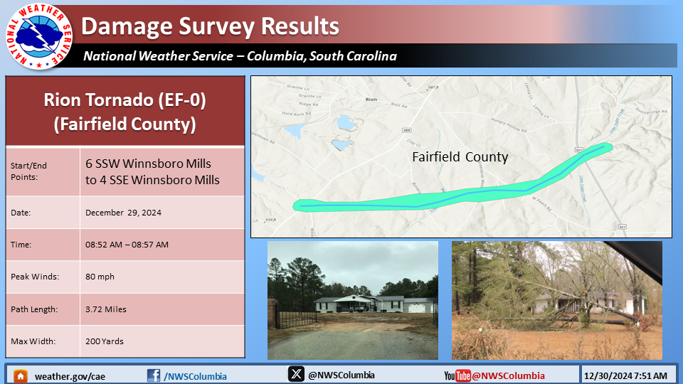
...Rion, SC EF-0 Tornado in Fairfield County...

Rating:                 EF0
Estimated Peak Wind:    80 mph
Path Length /statute/:  3.72 miles
Path Width /maximum/:   200 yards
Fatalities:             0
Injuries:               0

Start Date:             12/29/2024
Start Time:             08:52 AM EST
Start Location:         6 SSW Winnsboro Mills / Fairfield County / SC
Start Lat/Lon:          34.284 / -81.1391

End Date:               12/29/2024
End Time:               08:57 AM EST
End Location:           4 SSE Winnsboro Mills / Fairfield County / SC
End Lat/Lon:            34.297 / -81.0788

Survey Summary:
A National Weather Service storm survey team determined that a
weak EF-0 tornado, with peak wind speeds of 80 mph, occurred just
south of Rion.

The tornado began near Highway 269 and Mockingbird
Lane where it snapped a few limbs. The tornado continued east,
crossing Bundrick Road where it snapped large limbs, uprooted a
tree and caused minor shingle damage to a home. The tornado then
crossed Greenbrier Mossydale Road, High Hill Road and West Peach
Road where it resulted in minor tree damage and minor shingle
damage to a couple of homes.  The tornado then shifted northeast,
crossing Highway 321 where minor tree damage occurred, before
dissipating.

&&

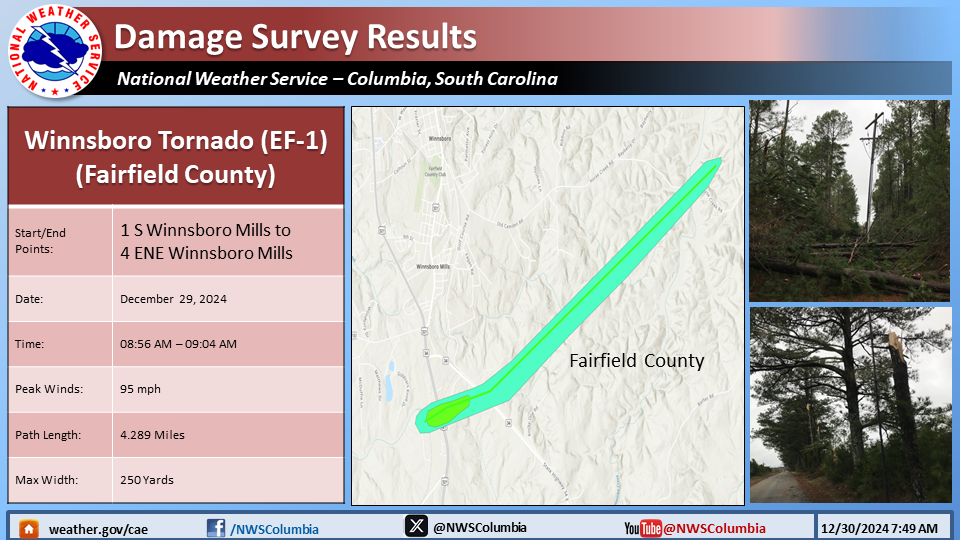
...Winnsboro, SC EF-1 Tornado in Fairfield County...

Rating:                 EF1
Estimated Peak Wind:    95 mph
Path Length /statute/:  4.89 miles
Path Width /maximum/:   250 yards
Fatalities:             0
Injuries:               0

Start Date:             12/29/2024
Start Time:             08:56 AM EST
Start Location:         1 S Winnsboro Mills / Fairfield County / SC
Start Lat/Lon:          34.3339 / -81.088

End Date:               12/29/2024
End Time:               09:04 AM EST
End Location:           4 ENE Winnsboro Mills / Fairfield County / SC
End Lat/Lon:            34.3693 / -81.0145

Survey Summary:
A National Weather Service storm survey team determined that an
EF-1 tornado, with peak wind speeds of 95 mph, occurred just
south of Winnsboro.

The tornado began just north of a manufacturing plant on Highway 321
and Guardian Way where it overturned four empty trailers and snapped
multiple utility poles. The tornado moved east across Highway 321
where it collapsed a large garage door on the east side of a food plant
then snapped numerous trees along Industrial Park Road. The
tornado then moved across Highway 34E where it snapped several
trees and snapped power poles near a medical manufacturer. The
tornado moved through an inaccessible wooded area, before
crossing Horse Creek Road and dissipating.

&&

EF Scale: The Enhanced Fujita Scale classifies tornadoes into the
following categories:

EF0.....65 to 85 mph
EF1.....86 to 110 mph
EF2.....111 to 135 mph
EF3.....136 to 165 mph
EF4.....166 to 200 mph
EF5.....>200 mph

NOTE:
The information in this statement is preliminary and subject to
change pending final review of the events and publication in
NWS Storm Data.

$$

MG/JAQ/DH/HC
