
In the Upper Midwest, heavy to excessive rain may bring flash and urban flooding through Wednesday. Scattered severe thunderstorms capable of large hail and damaging wind gusts are possible from the central High Plains into the Upper Midwest Wednesday. Extreme heat is ongoing over the Desert Southwest through Thursday. Read More >
| Location | Estimated Start Time | Maximum EF-Scale Rating | Estimated Maximum Wind Speed | Maximum Path Width | Path Length | Fatalities | Injuries |
|---|---|---|---|---|---|---|---|
| Olar, SC | 7:01 PM | EF0 | 85 MPH | 50 yards | 2 miles | 0 | 0 |
On September 11th 2017 at 2 pm EDT, the center of Tropical Storm Irma was located near the Florida/Georgia border. The extent of tropical storm force winds was large and reached into the southern portions of North Carolina (below). The Midlands and Central Savannah River Area (CSRA) were in the front-right quadrant of Tropical Storm Irma, which is historically favorable for tropical tornadoes.
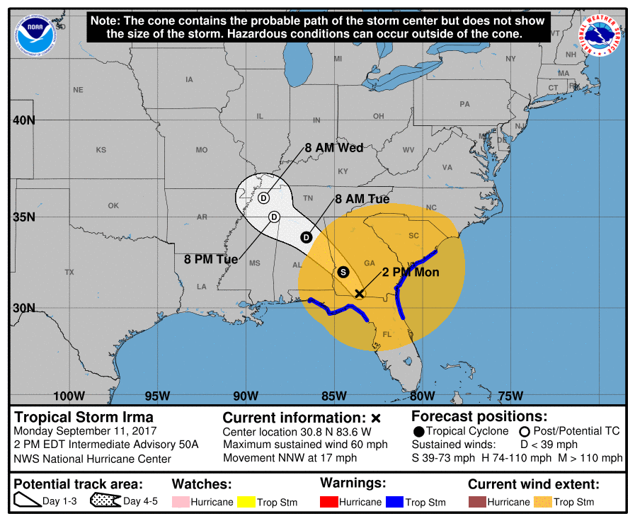
Sep 11, 2017, 2 PM EDT Advisories on Tropical Storm Irma (National Hurricane Center)
During much of the day, the Midlands and CSRA experienced cool, low-level flow from the northeast. This created a stable environment which is unfavorable for tornadoes. However during the evening, Irma had moved far enough to the north to produce southeasterly winds over portions of the southern Midlands. This would draw warm, moist air from over the Atlantic shoreline into the region. Very strong 0-1 km Storm Relative Helicity (Figure 1) would allow small vortices to form in the bands of convection. The warming surface temperatures provided just enough surface-based instability (Figure 2) to stretch these small vortices to the ground in the form of a tornado.
Figure 1. Sep 11, 2017, 7 PM EDT 0-1 km Storm Relatively Helicity (SRH)​ and Storm Motion Vector (Mesoanalysis from Storm Prediction Center)
Figure 2. Sep 11, 2017, 7 PM EDT surface based Convective Available Potential Energy (J/kg) and surface winds (knots) (Mesoanalysis from Storm Prediction Center)
Storm Relative Velocity images (Figure 3) from the KCAE radar show a rotational couplet tightening just before 7 pm. The tornado touched down at approximately 7:01 pm just north of Olar, SC based on the NWS Damage Survey. It crossed several small roads, snapping branches and uprooting trees before dissipating approximately 4 minutes after touchdown, just west of Govan, SC.
Note that the sudden change in color seen as the rotational couplet nears Govan, SC is an artifact of the radar due to the high wind speeds associated with Tropical Storm Irma.
Figure 3. Sep 11, 2017 KCAE 0.5° Storm Relative Velocity (SRV) Loop from 6:53 pm to 7:09 pm.
Rating:                 EF0
Estimated Peak Wind:    85 mph
Path Length /statute/:  2 miles
Path Width /maximum/:   50 yards
Fatalities:             0
Injuries:               0

Start Date:             September 11 2017
Start Time:             7:01 PM EDT
Start Location:         0.5 miles NNW of Olar, SC
Start Lat/Lon:          33.19/-81.19

End Date:               September 11 2017
End Time:               7:05 PM EDT
End Location:           1 mile W of Govan, SC
End Lat/Lon:            33.22/-81.20

Click image for larger view
...Summary...
The National Weather Service in Columbia has confirmed a tornado
near Near Olar in Bamberg County South Carolina on 09/11/2017.

The tornado was associated with the remnants of Hurricane Irma. The
tornado touched down just northwest of the town of Olar along Thunder
Road. The tornado continued north-northwest for approximately 2 miles.
The tornado crossed Thunder Road...Red Fox Road...Memorial Church Road
and dissipated before reaching Earhardt Road. The tornado downed a few
trees and several large limbs along it's path. The tornado was brief,
only staying on the ground for approximately 4 minutes.
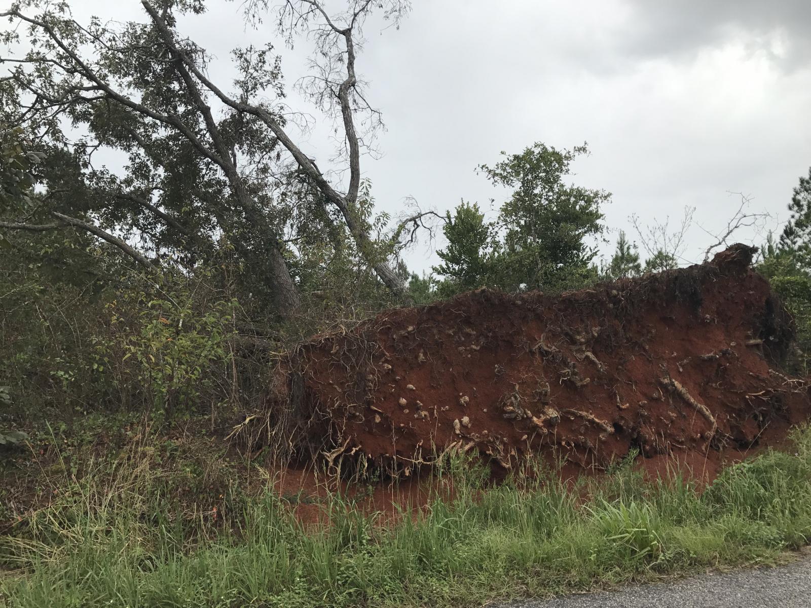
Trees uprooted from EF0 tornado on September 11, 2017.
For reference: the Enhanced Fujita Scale classifies tornadoes
into the following categories:

EF0...Wind speeds 65 to 85 mph
EF1...Wind speeds 86 to 110 mph
EF2...Wind speeds 111 to 135 mph
EF3...Wind speeds 136 to 165 mph
EF4...Wind speeds 166 to 200 mph
EF5...Wind speeds greater than 200 mph

