Effective on or about Tuesday, March 30, 2021, at 8:00 AM Eastern Standard Time (EST), The NWS Weather Forecast Office (WFO) in Columbia, South Carolina (CAE) will change Public and Fire Weather Forecast Zones for Orangeburg County in central South Carolina. After this change, all public and fire weather forecasts and related products will use the new zone numbers and names shown below. If Tuesday, March 30, 2021 is declared a Critical Weather Day, this implementation will be postponed to Thursday, April 1, 2021.
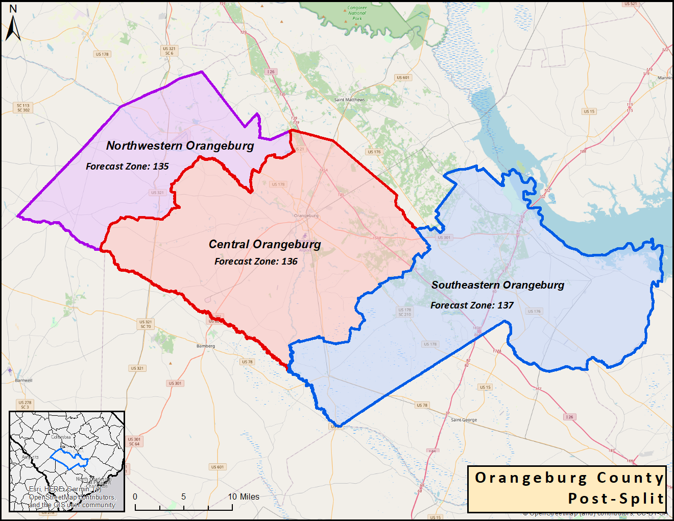
One current zone (SCZ036) will be converted into three separate zones. These changes are intended to provide increased flexibility and improved accuracy of forecast and various watches, warnings and advisories in the public and fire weather programs. The new zones are as follows:
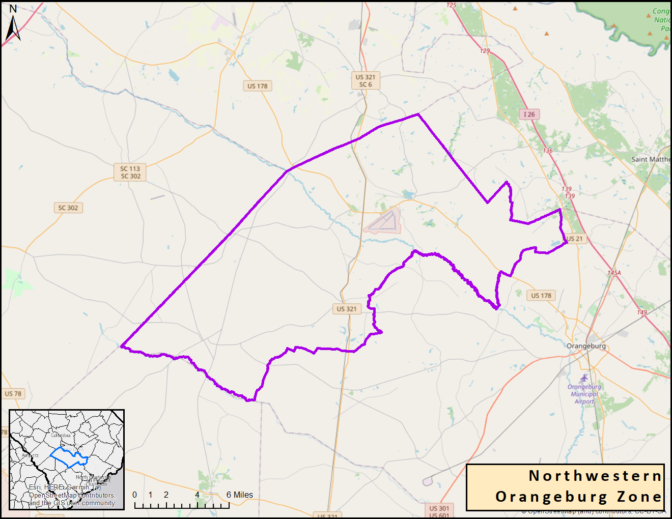
SCZ135: Northwestern Orangeburg County (to include the Neeses, North, Sawyerdale, Springfield, and Wolfton local fire districts)
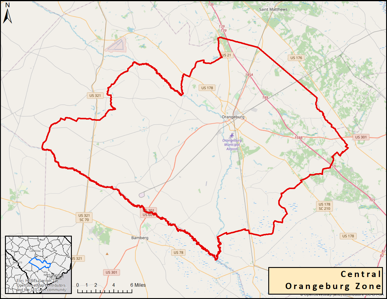
SCZ136: Central Orangeburg County (to include the Bolentown, Canaan, Cordova, Edisto, Four Holes, Jamison, Norway, Orangeburg, Pinehill, Rowesville, and West Middle local fire districts)
SCZ137: Southeastern Orangeburg County (to include the Bowman, Branchville, Cattle Creek, Elloree, Eutawville, Holly Hill, Providence, Santee, and Vance local fire districts)
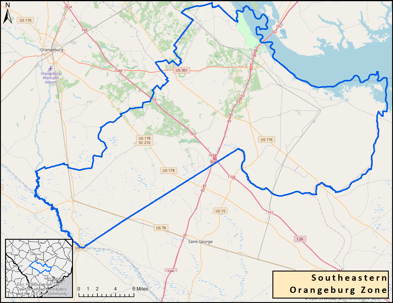
Below are graphics depicting these changes:
|
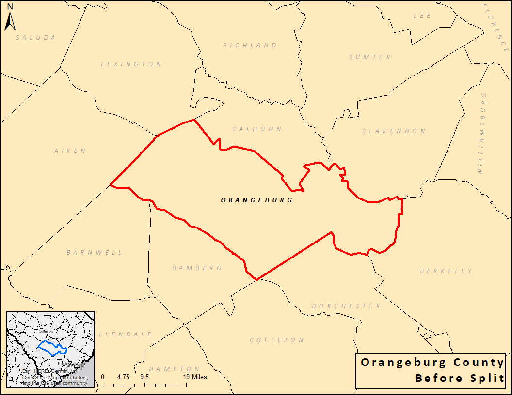
Previous Orangeburg County, SC Zone
|
New Orangeburg County, SC Zones
|
|
Northwestern Orangeburg County, SC Zone
|
Central Orangeburg County, SC Zone
|
Southeastern Orangeburg County, SC Zone
|
The zone changes are needed because Orangeburg County is the second largest county by area in South Carolina at about 1,128 sq. miles. It also extends just over 65 miles from the far western part to the far eastern part of the county. Forecast services will be improved by this new configuration given the differing weather conditions found across the county, especially during winter weather events and tropical systems that run parallel to the coast.
The new zone configuration will allow for more location specific forecasts, watches, warnings, and advisories. By decreasing the area covered by watches and warnings for events such as winter storms and tropical cyclones, unnecessary closures of schools and businesses should be reduced in the appropriate circumstances. Similarly, it will limit the opening of shelter to only necessary areas. It will also better serve the two media markets (Columbia and Charleston) that cover the county.
The proposed changes to the CAE zone boundaries have been closely coordinated with local partners and customers.
These zone changes require partners and users to take appropriate action to receive the new zone products using the Universal Generic Code (UGC) zone code format (Z) listed in Table 1. Products affected by this change are listed in Table 2.
| Current Public/Fire Zone Name / UGC | New Public/Fire Zone Name / New UGC |
|
Orangeburg / SCZ036 |
Northwestern Orangeburg / SCZ135 Central Orangeburg / SCZ136 Southeastern Orangeburg / SCZ137
|
| Product Name | WMO Header | AWIPS ID |
|
Special Weather Statement Hurricane Local Statement Tropical Cyclone Watch/Warning Zone Forecast Product Hazardous Weather Outlook Non-Precipitation Watch/Warning/Advisory Winter Weather Watch/Warning/Advisory Area Forecast Matrices Fire Weather Message Flood Watch/Warning/Advisory Hydrologic Outlook Fire Weather Watch/Red Flag Warning Public Information Statement Point Forecast Matrices Area Forecast Discussion Precipitation and Temperature Summary Daily River and Lake Summary Hydrologic Statement Hydrologic Statement Air Quality Alert Air Quality Forecast Flood Warning (River Fcst Point) Flood Statement Hydrologic Outlook Flood Watch (River Fcst Point) Flash Flood Warning Flash Flood Statement |
WWUS82 KCAE WTUS82 KCAE WTUS82 KCAE FPUS52 KCAE FLUS42 KCAE WWUS72 KCAE WWUS42 KCAE FOUS52 KCAE FNUS52 KCAE WGUS62 KCAE FGUS72 KCAE WWUS82 KCAE NOUS42 KCAE FOUS52 KCAE FXUS62 KCAE SXUS52 KCAE FGUS52 KCAE FGUS82 KCAE SRUS42 KCAE AEUS72 KCAE AEUS72 KCAE WGUS46 KCAE WGUS82 KCAE FGUS73 KCAE WGUS63 KCAE WGUS51 KCAE WGUS71 KCAE |
SPSCAE HLSCAE TCVCAE ZFPCAE HWOCAE NPWCAE WSWCAE AFMCAE FWFCAE FFACAE ESFCAE RFWCAE PNSCAE PFMCAE AFDCAE HYDCAE RVDCAE RVSCAE RVACAE AQACAE AQICAE FLWCAE FLSCAE ESFCAE FFACAE FFWCAE FFSCAE |
If you are affected by these changes, take the appropriate action so your system(s) recognize the new zone (Z) Universal Geographic Codes (UGC) and the new zone alignments and names.
An updated public zone map shapefile is available for download at: http://www.nws.noaa.gov/geodata/catalog/wsom/html/pubzone.htm
An updated fire zone map shapefile is available for download at: http://www.nws.noaa.gov/geodata/catalog/wsom/html/firezone.htm
|
John Quagliariello Warning Coordination Meteorologist National Weather Service Columbia, SC 2909 Aviation Way West Columbia, SC 29170 803-822-8135 John.Quagliariello@noaa.gov |
John Koch Public Program Leader National Weather Service Eastern Region Headquarters 630 Johnson Avenue Bohemia, NY 11716 631-244-0104 John.Koch@noaa.gov |