| Location | Estimated Start Time | Maximum EF-Scale Rating | Estimated Maximum Wind Speed | Maximum Path Width | Path Length | Fatalities | Injuries |
|---|---|---|---|---|---|---|---|
|
Saluda County SC
|
2:40 PM | EF-1 | 110 MPH | 75 yards | 3 miles | 0 | 0 |
| Saluda/Newberry County, SC | 3:04 PM | EF-2 | 115 MPH | 115 yards | 12 miles | 0 | 0 |
| Lancaster/Union County, SC | 4:19 PM | EF-1 | 100 MPH | 50 yards | 8 miles | 0 | 0 |
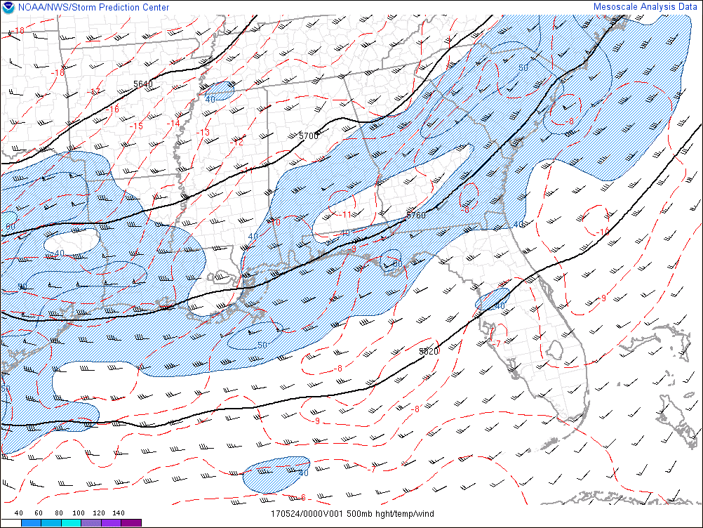
On May 23-25 2017, an unusually strong upper level low pressure system moved through the Southeastern United States, as is shown in the 500 mb loop below.
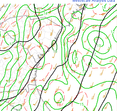
At the surface, a cold front extended south from a deep surface low pressure over western Tennessee/North Alabama in the morning.
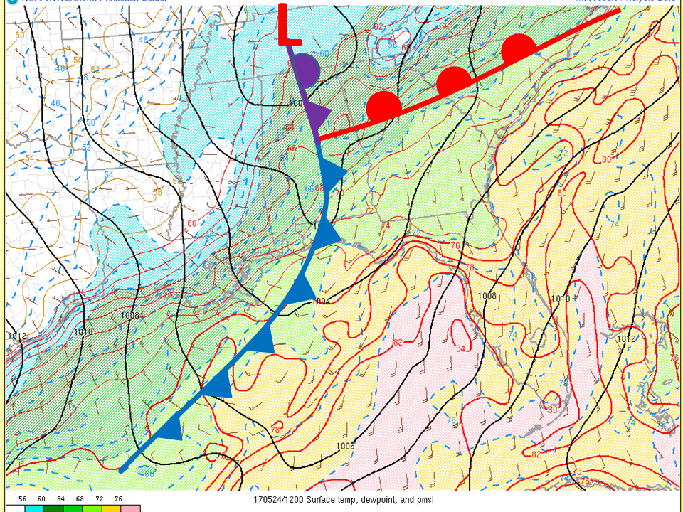
May 24, 2017, 8 AM EDT Surface Analysis (Mesoanalysis from Storm Prediction Center)
The front approached the coastal Southeastern States by afternoon.
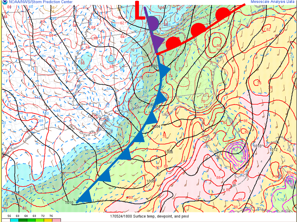
May 24, 2017, 2 PM EDT Surface Analysis (Mesoanalysis from Storm Prediction Center)
Much stronger than normal mid-level winds crossed Georgia and South Carolina during the afternoon of May 24th, creating a large amount of shear, with the SPC mesoanalysis at 2 PM EDT showing 60-70 knots.
May 24, 2017, 2 PM EDT Effective Layer Shear (Mesoanalysis from Storm Prediction Center)
As the front approached north Georgia and the Carolinas, moisture increased aided by a strong south low level jet max 40 to 50 knots.
May 24, 2017, 5 PM EDT 850 mb height/dewpoint/wind vectors (Mesoanalysis from Storm Prediction Center)
The air mass across the region was moderately unstable with SB CAPE 1500-2500 J/kg.
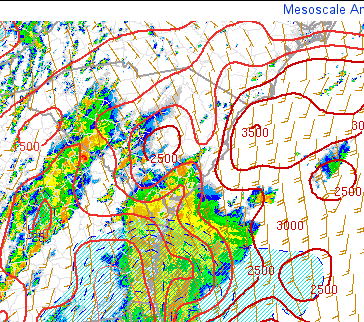
May 24, 2017, 2 PM EDT surface based Convective Available Potential Energy (J/kg) and surface winds (knots) (Mesoanalysis from Storm Prediction Center)
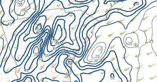
High Resolution Model Hodographs suggested an increased threat for strong Tornadoes with 0-3km SR-Helicity around 300 m2/s2.
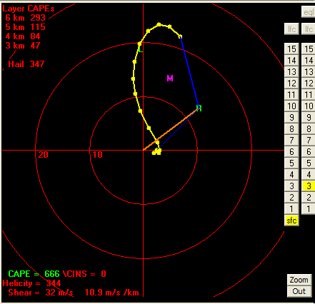
May 24, 2017, 4 PM HRRR Analysis Hodograph at CAE (Bufkit)
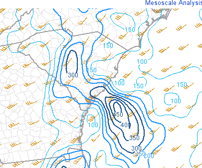
May 24, 2017, 4 PM EDT 0-3 km Storm Relatively Helicity (SRH)​ and Storm Motion Vector (Mesoanalysis from Storm Prediction Center)
The Quasi-Linear Convective System (QLCS) that eventually spawned the tornadoes in Saluda and Newberry counties organized in the early afternoon over east central Georgia associated with strengthening low-level jet max and approaching strong mid-level short wave trough. Other discrete cells developed to the east and exhibited weak shallow rotation.
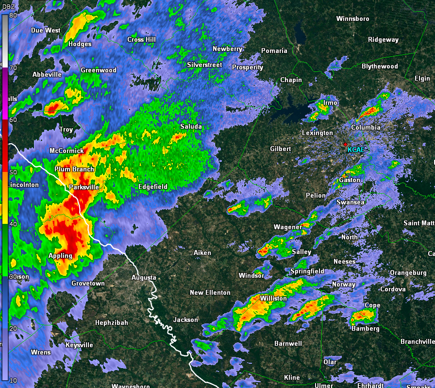
By 215 PM, the QLCS developed broad rotation and a strong rear inflow jet.
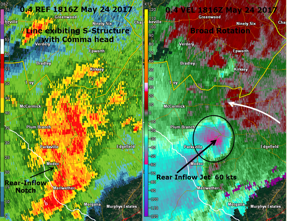
May 24, 2017 2:16 PM KCAE 0.4° Reflectivity and Base Velocity.
A Broken-S signature was evident in the radar Reflectivity product by 228 PM EDT near the north Edgefield/Saluda County border and there was strong evidence in the Storm Relative Motion products (SRM) that tornadogenesis was beginning. The rotational velocity increased to 36 knots (gate-to- gate) at about 3200 feet above the surface.
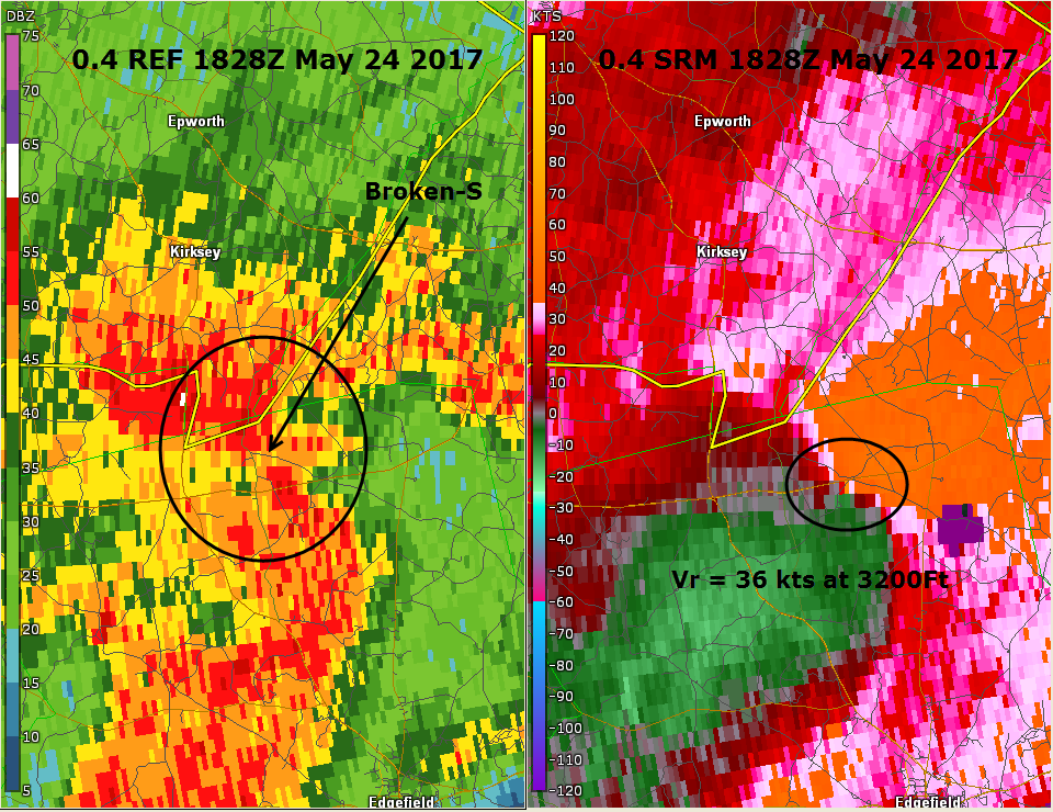
May 24, 2017 2:28 PM KCAE 0.4° Reflectivity and Storm Relative Motion (SRM).
Between 2:38 and 2:41 PM EDT, a clear Tornado Debris Signature (TDS) developed in the correlation coefficient field.
.png)
May 24, 2017 2:38 and 2:41 PM​ KCAE 0.4° Correlation Coefficient (CC).
As the tornadic thunderstorm moved rapidly to the northeast around 50 mph into Newberry County, the rotation remain strong and even strengthened as seen in the 0.4o SRM when the rotational velocity increased to 49 knots (gate-to-gate) at 1700 ft.
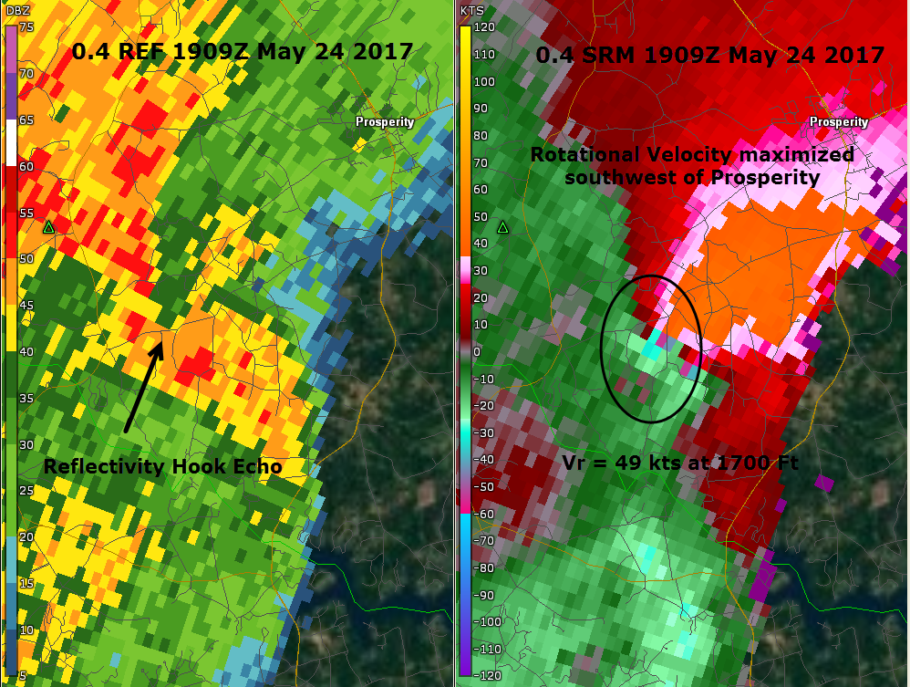
May 24, 2017 3:09 PM KCAE 0.4° Reflectivity and Storm Relative Motion (SRM).
As the storm approached Fairfield to the northeast of the town of Prosperity, the storm rotation weakened.
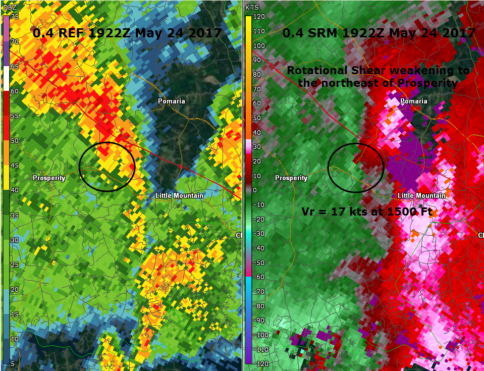
May 24, 2017 3:22 PM KCAE 0.4° Reflectivity and Storm Relative Motion (SRM).
Here is a 4-panel loop of the Saluda and Newberry County tornadoes.
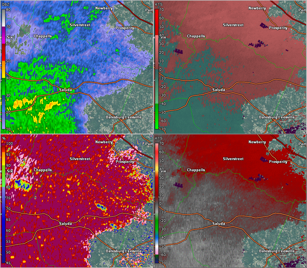
May 24, 2017 KCAE 0.4° Reflectivity (Upper Left), SRM (Upper Right), CC (Lower Left) and Base Velocity (Lower Right).
Public Information Statement for the Saluda and Newberry County Tornadoes
Just after the tornado in Newberry County lifted, a new area of concern developed. A cell merger took place in southeastern Chester County initiating a weak rotation near Great Falls. The cell continued to organize, and by 350 PM EDT, the low level rotation had tightened and an appendage began to form on the southwest side.
.png)
May 24, 2017 3:50 PM KCAE 0.4° Reflectivity (Right) and Storm Relative Motion (SRM left).
The rotation was at its tightest at 405 PM EDT, while an appendage was still visible on the base reflectivity just southeast of Lancaster.
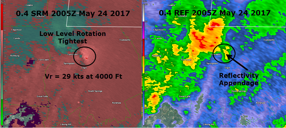
May 24, 2017 4:05 PM KCAE 0.4° Reflectivity (Right) and Storm Relative Motion (SRM left).
After that time, the signature on the KCAE WSR-88D became more diffuse. Near the time of touchdown, the rotation appeared weaker, and a rather nebulous reflectivity representation could be seen as the cell moved north northeastward toward the North Carolina border.
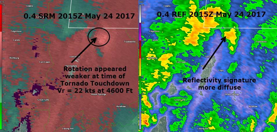
May 24, 2017 4:15 PM KCAE 0.4° Reflectivity (Right) and Storm Relative Motion (SRM left).
However, we also have access to the Terminal Doppler Radar from Charlotte-Douglas airport (TCLT). Since the cell of interest was much closer to Charlotte than Columbia, the velocity product from TCLT was investigated. It was clear, as shown in the loop below, that there was still a tight circulation at low levels, which could not be seen from KCAE.
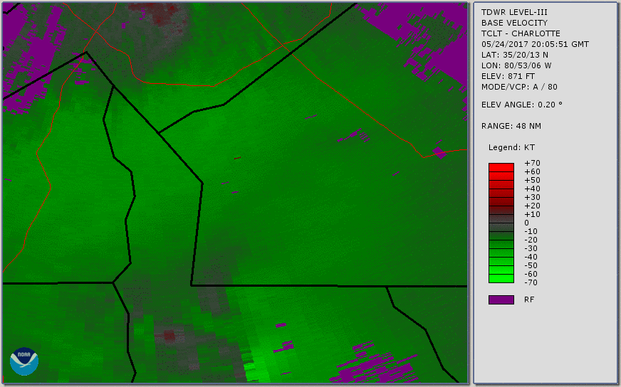
May 24, 2017 TCLT Base Velocity Loop.
Public Information Statement for the Lancaster County Tornado
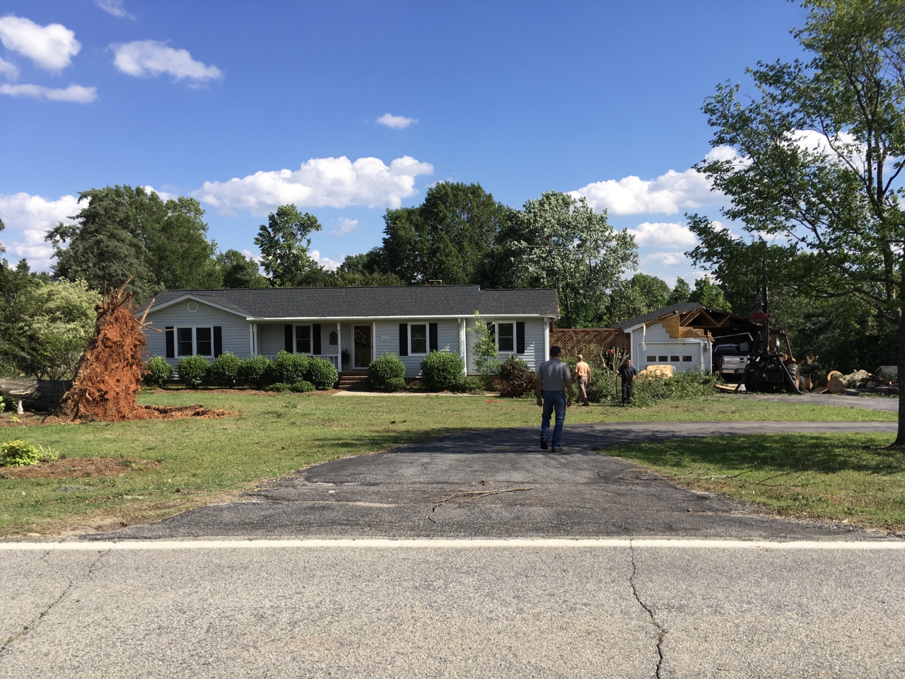
Damage to home near Prosperity, SC on May 24, 2017
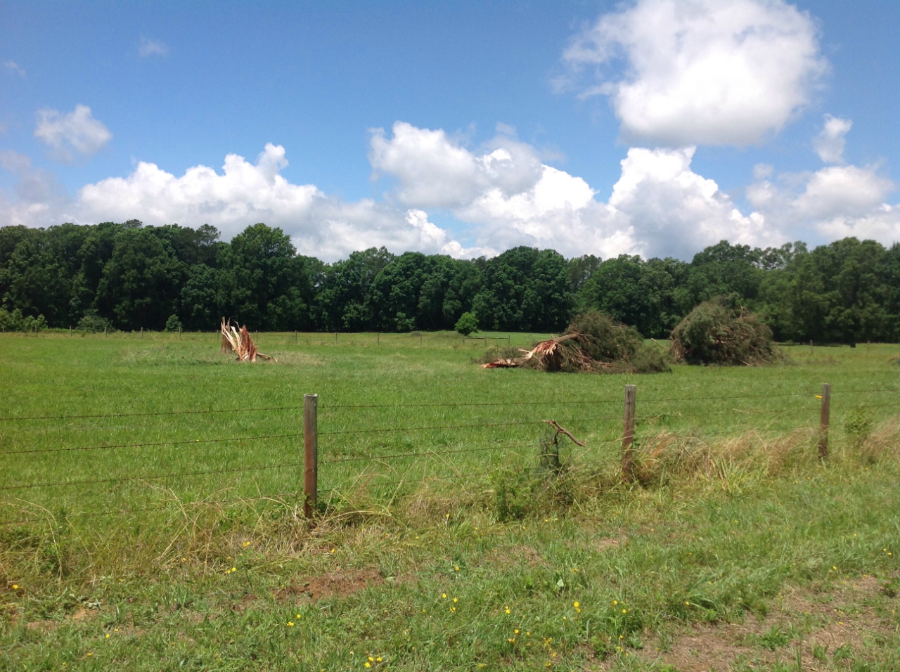
Cedar trees snapped and tossed across a field near Saluda, SC on May 24, 2017
Rating:                 EF-1
Estimated Peak Wind:    110 mph
Path Length /statute/:  3 miles
Path Width /maximum/:   75 yards
Fatalities:             0
Injuries:               0

Start Date:             May 24 2017
Start Time:             2:40 PM EDT
Start Location:         6 miles W of Saluda
Start Lat/Lon:          33.99/-81.88

End Date:               May 24 2017
End Time:               2:47 PM EDT
End Location:           4 miles NW of Saluda
End Lat/Lon:            34.02/-81.85
Click image for larger view
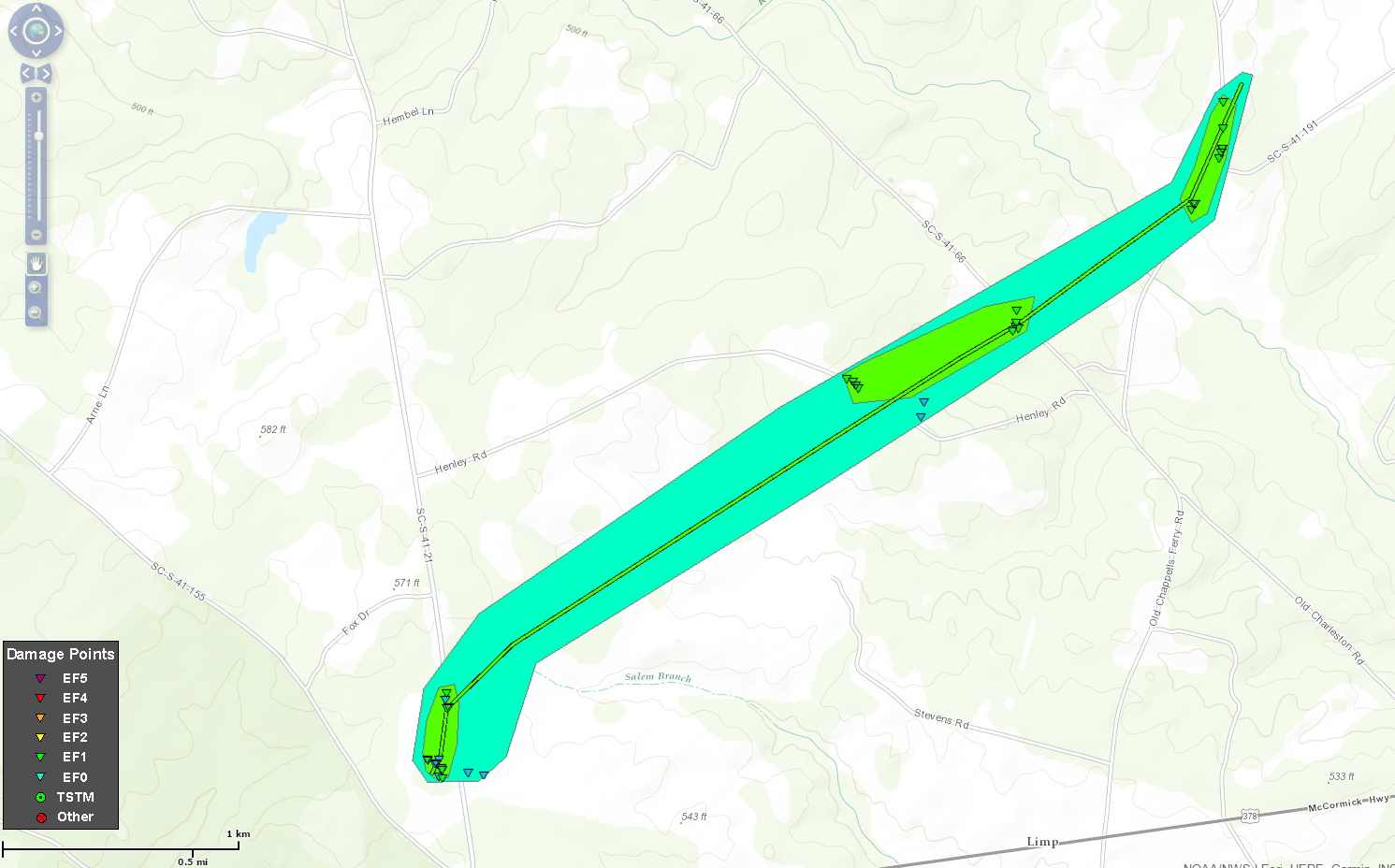
...Summary...
The National Weather Service in Columbia has confirmed a tornado
in Saluda County in South Carolina on May 24, 2017.

A tornado touched down near Fruit Hill Road just north of Highway
378. Then continued northeast crossing Henley Road and Old
Charleston Road. The tornado produced EF-0 and EF-1 damage,
traveling a total of 3 miles before lifting near the intersection
of Old Chappell Ferry Road and Simmons Road. Numerous trees were
either snapped or uprooted along the damage path and sheet metal
was lifted off the roof of a small outbuilding. The strongest wind
speeds of up to 110 mph occurred on Fruit Hill Road where 2 cedar
trees were snapped at the trunks and thrown up to 20 yards.
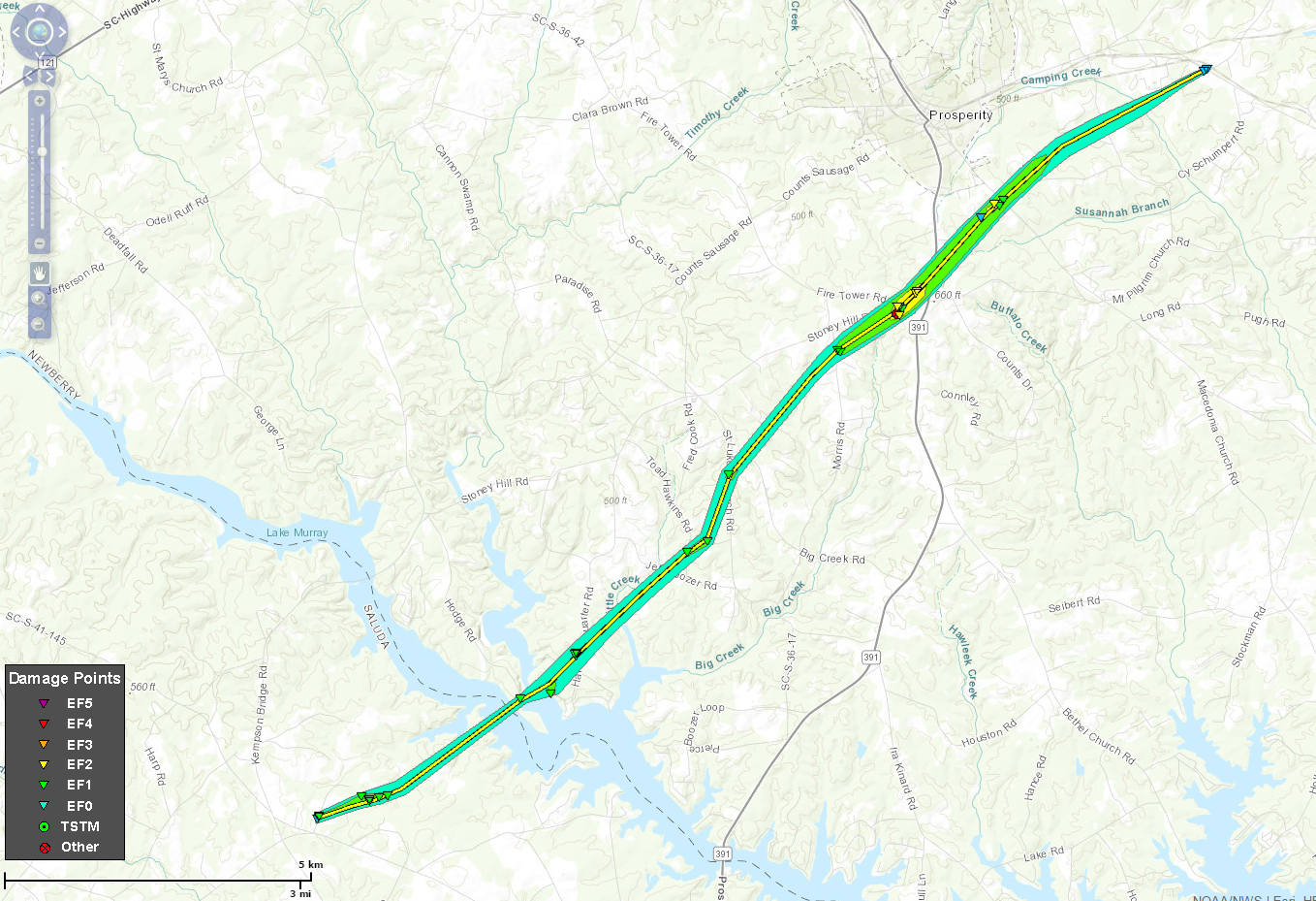
Rating:                 EF-2
Estimated Peak Wind:    115 mph
Path Length /statute/:  12 miles
Path Width /maximum/:   250 yards
Fatalities:             0
Injuries:               0

Start Date:             May 24 2017
Start Time:             304 PM EDT
Start Location:         10 miles NE of Saluda, SC
Start Lat/Lon:          34.01/-81.64

End Date:               May 24 2017
End Time:               320 PM EDT
End Location:           3 miles E of Prosperity, SC
End Lat/Lon:            34.22/-81.48
Click image for larger view
..Summary...
The National Weather Service in Columbia has confirmed a tornado
in Northern Saluda and Newberry Counties in South Carolina on May
24, 2017.

A tornado touched down near Denny Highway in Northern Saluda
County, about 2 miles southwest of the Saluda River. The tornado
then continued northeast across the Saluda River and into Newberry
County, eventually passing about 2 miles south of Prosperity and
dissipating about 3 miles east of Prosperity near Mid Carolina
High School. The tornado had a path length of 12 miles and a
maximum width of 250 yards, producing EF-0 and EF-1 damage along
most of its path. However, there was a small area of EF-2 wind
damage with winds up to 115 mph near Stoney Hill Road and Fire
Tower Road, and also near Macedonia Church Road and Cy Schumpert
Road.

Numerous trees were either snapped or uprooted along the damage
path, with several trees down on homes and vehicles. Where the
tornado was strongest, several masonry outbuildings had their
walls blown out. Small outbuildings were moved as much as 20
yards, and a few very large hardwood trees were splintered with
the tops thrown as much as 30 yards.
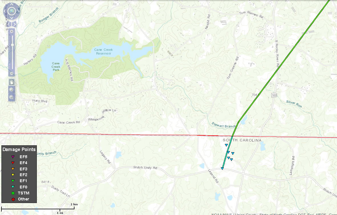
Estimated Time:                4:19 PM
Maximum EF-Scale Rating:       EF1
Estimated Maximum Wind Speed:  100 mph
Maximum Path Width:            50 yards
Path Length:                   8 miles
Fatalities:                    0
Injuries:                      0
Click image for larger view
...Summary...
The National Weather Service in Columbia has confirmed a tornado northeast
of Lancaster in Lancaster County South Carolina on 05/24/2017.

A tornado touched down northeast of Lancaster close to the North
Carolina State Line near Shiloh Unity Road. The tornado continued
northward causing EF-0 damage to crops and trees near Locker Road.
The tornado was in Lancaster County for 0.5 miles having a path
width of no more than 50 yards. The maximum wind speed during this
time was 75 mph.

The tornado moved across the state line and tracked northeast for
over 7 miles. Most of the damage was to trees but a few
structures were damaged. The most significant damage was to a barn
that had the sides and much of the roof torn off. This area
received a rating of EF-1 with maximum winds speeds of 100 mph.
EF0...Weak......65 TO 85 mph
EF1...Weak......86 TO 110 mph
EF2...Strong....111 TO 135 mph
EF3...Strong....136 TO 165 mph
EF4...Violent...166 TO 200 mph
EF5...Violent...>200 mph


