Morning convection across southern Missouri quickly developed into a mesoscale convective system (MCS) as it moved southeastward during the afternoon of Tuesday, March 21 2017. An embedded mesoscale convective vortex (MCV) pushed into the Central Savannah River Area (CSRA) and southern Midlands during the evening hours. Discrete supercell thunderstorms also developed in the lee of the Appalachian Mountains over the Upstate of South Carolina (SC). These cells merged to form a line of severe storms which then accelerated into the central Midlands producing a large swath of damaging winds.
Environmental conditions favored long-lived MCS development on March 21. Strong insolation and warm advection south of a cold front resulted in steepening low level lapse rates with either near record or record breaking temperatures. In addition, low level moisture advection during the afternoon resulted in a very unstable air mass as the MCS approached the region.
.gif)
March 21, 2017, 5 PM EDT surface observations (Mesoanalysis from Storm Prediction Center)
An initially capped airmass became moderately unstable as moisture advection increased throughout the day. Mixed-level Convective Available Potential Energy (CAPE) values at 5 PM ranged from 500 to 2000 J/kg with highest values over the CSRA.

March 21, 2017, 5 PM EDT mixed level Convective Available Potential Energy (J/kg) (Mesoanalysis from Storm Prediction Center)
At the mid-levels, a dry Elevated Mixed Layer (EML) would support the threat for damaging winds. The 18z sounding gathered from the Atlanta, GA WFO observed mid-level lapse rates in excess of 8 C/km. These steep lapse rates and mid-level dry air led to downdraft CAPE values around 1000 J/kg indicating the enhanced potential for damaging winds.
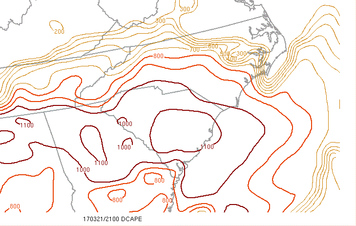
March 21, 2017, 5 PM EDT Downdraft/DCAPE (J/kg) (Mesoanalysis from Storm Prediction Center)
The magnitude of the mean wind vector also favored forward-propagating convective lines with values ranging from 20 to 30 knots.

March 21, 2017, 5 PM EDT 850 to 300 mb mean wind (knots) (Mesoanalysis from Storm Prediction Center)
Additional upper level support was provided by a shortwave trough that moved over the region.

March 21, 2017, 5 PM – March 22, 2017, 1 AM EDT 500 mb height and vorticity (Mesoanalysis from Storm Prediction Center)
The High Resolution Rapid Refresh (HRRR) model provides forecast reflectivity and in this event performed very well showing the initial cellular convection developing in the Upstate of South Carolina and then merging into a more organized area of storms that accelerated southeastward through the Midlands.

March 21 6PM - March 22 2AM EDT HRRR model reflectivity forecast loop
GOES-16 Infrared Satellite imagery showed in detail the individual updrafts (dark red colors) of the stronger storms as they developed and moved southeastward into the Midlands and Central Savannah River Area.
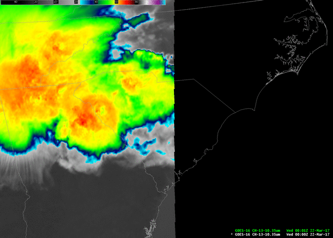
March 21 8PM - March 22 1AM EDT GOES-16 Infrared Satellite Imagery (Channel 13). The GOES-16 data posted on
this page are preliminary, non-operational data and are undergoing testing. Users bear all responsibility
for inspecting the data prior to use and for the manner in which the data are utilized
Increasing low level moisture and lift along the higher terrain of the SC Upstate and northeast GA became strong enough to produce deep, moist convection around 5 PM on the afternoon of March 21, 2017. A radar loop of the entire convective event shows the evolution of the storms first initiating as discrete supercell thunderstorms in the Upstate of South Carolina and northern Georgia where very large hail was reported (golf ball and tennis ball size hail!). During the late afternoon and early evening hours, the mode of convection transitioned from discrete supercells to more multicellular convection as upper level energy moved into the region from the west which helped intensify and accelerate the storms to the southeast.
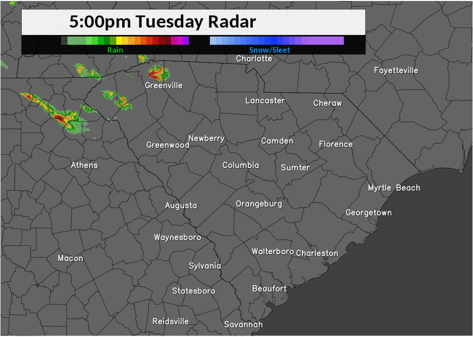
March 21, 2017, 5 PM - March 22, 2017, 2 AM EDT multi-radar multi-sensor lowest level reflectivity (Radar loop from NWS WAVE website)
A large area of 50 knot winds was observed from the KCAE WSR-88D radar with isolated pockets of 70 knot winds or greater.
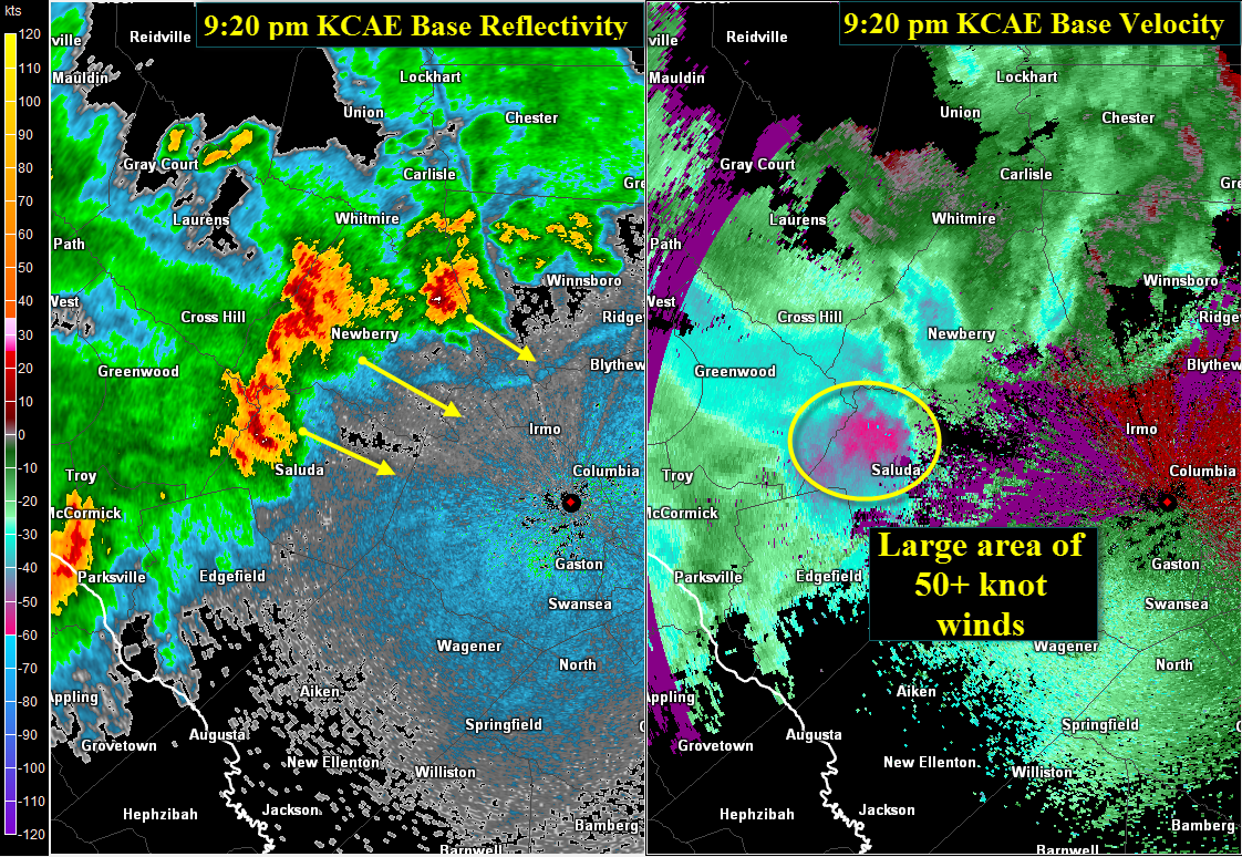
March 21, 2017, 9:20 PM EDT KCAE radar reflectivity (Z) and base velocity (BV)

March 21, 2017, 9:31 PM EDT KCAE radar reflectivity (Z) and base velocity (BV)
An embedded MCV was evident on radar imagery as it moved through the CSRA and southern Midlands. The threat for damaging winds increased across the region due to the enhancement of the cold pool associated with the strengthening rear inflow jet.

March 21, 2017, 9:10 PM to March 22 2017 12 AM EST KCAE radar reflectivity loop (Z)
There were several reports of wind damage and hail across the region with 28 reports of wind damage within the NWS Columbia Forecast Area, mainly from late afternoon through midnight on March 21st.
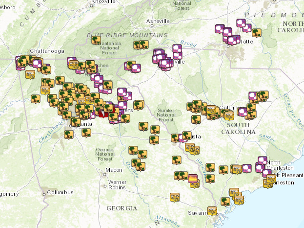
Regional local storm report map for March 21-22, 2017 (tree icon represents wind damage, pink icons
represent hail)

Waynesboro, GA. A metal roof was peeled back due to severe winds on March 21, 2017

Large trees uprooted near Augusta, GA due to severe winds on March 21, 2017

Tree fell on house near Augusta, GA due to severe winds on March 21, 2017

