HOME
FORECAST
Local
Graphical
Aviation
Marine
Rivers and Lakes
Hurricanes
Severe Weather
Fire Weather
Sunrise/Sunset
Long Range Forecasts
Climate Prediction
Space Weather
PAST WEATHER
Past Weather
Heating/Cooling Days
Monthly Temperatures
Records
Astronomical Data
SAFETY
INFORMATION
Wireless Emergency Alerts
Brochures
Weather-Ready Nation
Cooperative Observers
Daily Briefing
Damage/Fatality/Injury Statistics
Forecast Models
GIS Data Portal
NOAA Weather Radio
Publications
SKYWARN Storm Spotters
StormReady
TsunamiReady
Service Change Notices
EDUCATION
NEWS
SEARCH
Search For
NWS
All NOAA
ABOUT
About NWS
Organization
For NWS Employees
National Centers
Careers
Contact Us
Glossary
Social Media
NWS Transformation
Local forecast by
"City, St" or ZIP code
Sorry, the location you searched for was not found. Please try another search.
Multiple locations were found. Please select one of the following:
Location Help
News Headlines
NWS Columbia CAE March 2025 Climate Summary
Customize Your
Weather.gov
Enter Your City, ST or ZIP Code
Remember Me
LOADING...
Columbia, SC
Weather Forecast Office
Drought and Precipitation Information
Weather.gov
>
Columbia, SC
> Drought and Precipitation Information
Current Hazards
Briefing Page
Winter
River Flooding
Local Outlook
Drought
Space
Thunderstorms
Hurricanes
Current Conditions
Satellite
Rainfall
Air Quality
Observations (Map)
Observations (List)
Radar
Local KCAE Enhanced Radar
Local KCAE Standard Radar (low bandwidth)
Regional Standard Radar (low bandwidth)
National Standard Radar (low bandwidth)
CLT TDWR Radar
Forecasts
Map View
Hourly View
Forecasters' Discussion
Tropical
Aviation
Fire Weather
Rivers and Lakes
Current & Past Streamflow
Ensemble River Guidance
River Observations (Map)
River Forecast Centers
River Forecasts (Map)
Climate and Past Weather
CoCoRaHS
24 Hour Summary
Snowfall Records
Past Observed Weather
Past Rainfall
Drought Outlook
Historical Records
Climate Prediction
Tropical Cyclone Reports
Local Programs
NWR
Skywarn
Drought/Precipitation Information
Drought Outlook
U.S Seasonal Drought Outlook
Drought Outlook Discussion
U.S. Drought Monitor Weekly Assessment
U.S. Drought Monitor Web Site
Drought Indices
Palmer Drought Index
Explanation of Palmer Drough Index
Keetch-Byrum Index
Standardized Precipitation Index Maps
El Nino/La Nina Information
CPC El Nino/La Nina Page
Precipitation Information
24 hr pcpn amounts (
Midlands and CSRA )
24 hr pcpn graphics (
US
)
30 day graph for Columbia, SC
30 day graphs for Southeast U.S.
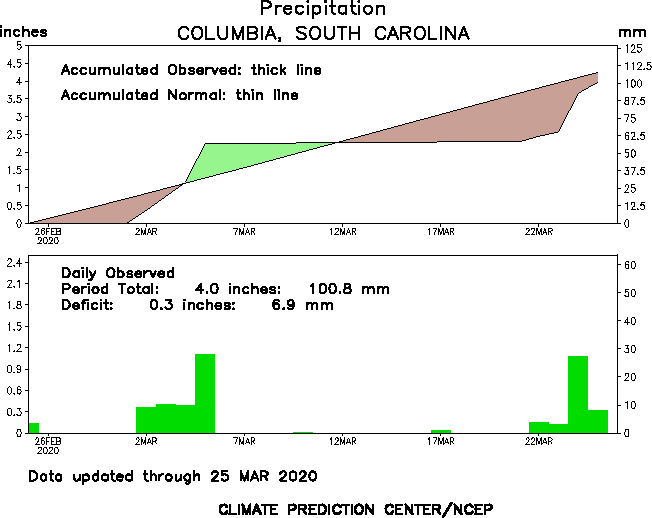
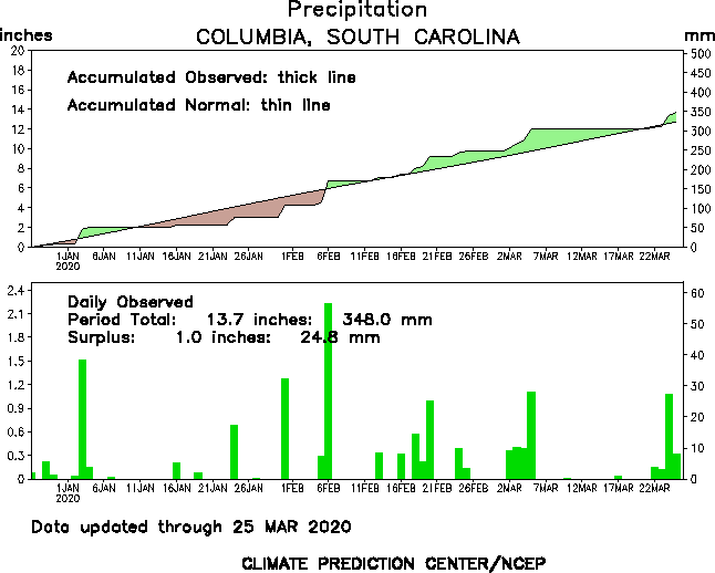
90 day graph for Columbia, SC
90 day graphs for Southeast U.S.
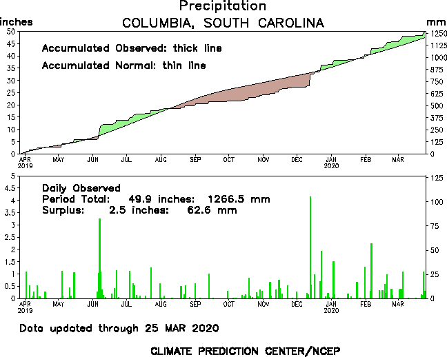
1 year graph for Columbia, SC
1 year graphs for Southeast U.S.
U.S. Climate Monitoring Weekly Products
Main Page
Radar
Current Weather
Rivers & Lakes
Satellite
Forecast Maps
Hour by Hour Forecast
Graphical Hazards
Winter Weather
Climate Plots
Weather Briefing
Regional Observations
Fire Weather
Forecaster's Discussion
Skywarn
Drought
Text Bulletins
Follow us on X
Follow us on Facebook
Follow us on YouTube
CAE RSS Feed


