Columbia, SC
Weather Forecast Office
...Snowfall Reports from around Central SC and East Central GA...
...Snowfall amounts and how they compare to the Record Books...
...Snowfall Pictures from Across the County Warning Area...
...Visible Satellite Image the day after the Event...
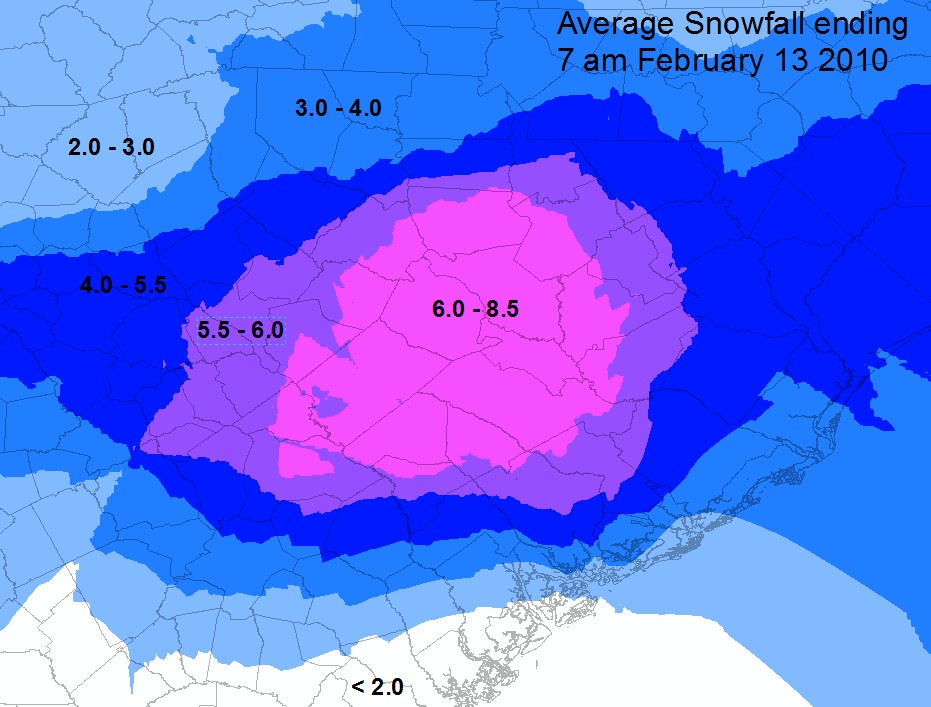
Preliminary Snowfall Totals
(Click map for larger image)
Hazards
Georgia
South Carolina
National Warnings
Hazardous Outlook
Tropical Weather
Weather Briefing
Provide Storm Reports
Email Alerts
Enhanced Hazardous Weather Outlook
GIS
KML/KMZ Data
Shapefile Data
Current Conditions
Observations
Satellite Images
Five Points
River and Lake Levels
River and Lake NWPS
Coop Reports
Lake Observations
Met Calculator
Mesonet Data
Radar
Charlotte TDWR
Columbia Radar
Nationwide
Forecasts
Winter
Activity Planner
Graphic Forecasts
Text Products
Aviation
Marine
Fire Weather
Air Quality
Forecast Discussion
RSS/XML
Experimental FRET
Hydrology
SC Streamflow
GA Streamflow
Drought Info
River and Lakes NWPS
Climate
Climate Plots
National
Local Climo
CoCoRaHs
Weather History Calendar
SERCC
NCEI
US Dept of Commerce
National Oceanic and Atmospheric Administration
National Weather Service
Columbia, SC
2909 Aviation Way
West Columbia, SC 29170-2102
(803) 822-8135
Comments? Questions? Please Contact Us.

