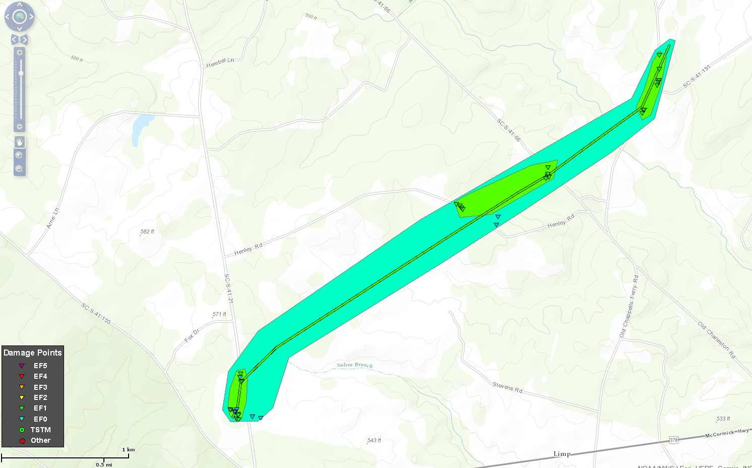
Rating:                 EF-1
Estimated Peak Wind:    110 mph
Path Length /statute/:  3 miles
Path Width /maximum/:   75 yards
Fatalities:             0
Injuries:               0

Start Date:             May 24 2017
Start Time:             2:40 PM EDT
Start Location:         6 miles W of Saluda
Start Lat/Lon:          33.99/-81.88

End Date:               May 24 2017
End Time:               2:47 PM EDT
End Location:           4 miles NW of Saluda
End Lat/Lon:            34.02/-81.85

Click image for larger view
...Summary...
The National Weather Service in Columbia has confirmed a tornado
in Saluda County in South Carolina on May 24, 2017.

A tornado touched down near Fruit Hill Road just north of Highway
378. Then continued northeast crossing Henley Road and Old
Charleston Road. The tornado produced EF-0 and EF-1 damage,
traveling a total of 3 miles before lifting near the intersection
of Old Chappell Ferry Road and Simmons Road. Numerous trees were
either snapped or uprooted along the damage path and sheet metal
was lifted off the roof of a small outbuilding. The strongest wind
speeds of up to 110 mph occurred on Fruit Hill Road where 2 cedar
trees were snapped at the trunks and thrown up to 20 yards.
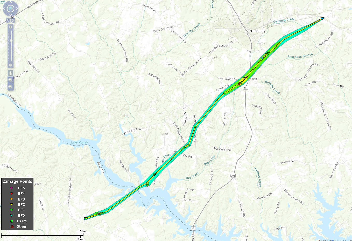
Rating:                 EF-2
Estimated Peak Wind:    115 mph
Path Length /statute/:  12 miles
Path Width /maximum/:   250 yards
Fatalities:             0
Injuries:               0

Start Date:             May 24 2017
Start Time:             304 PM EDT
Start Location:         10 miles NE of Saluda, SC
Start Lat/Lon:          34.01/-81.64

End Date:               May 24 2017
End Time:               320 PM EDT
End Location:           3 miles E of Prosperity, SC
End Lat/Lon:            34.22/-81.48
Click image for larger view
..Summary...
The National Weather Service in Columbia has confirmed a tornado
in Northern Saluda and Newberry Counties in South Carolina on May
24, 2017.

A tornado touched down near Denny Highway in Northern Saluda
County, about 2 miles southwest of the Saluda River. The tornado
then continued northeast across the Saluda River and into Newberry
County, eventually passing about 2 miles south of Prosperity and
dissipating about 3 miles east of Prosperity near Mid Carolina
High School. The tornado had a path length of 12 miles and a
maximum width of 250 yards, producing EF-0 and EF-1 damage along
most of its path. However, there was a small area of EF-2 wind
damage with winds up to 115 mph near Stoney Hill Road and Fire
Tower Road, and also near Macedonia Church Road and Cy Schumpert
Road.

Numerous trees were either snapped or uprooted along the damage
path, with several trees down on homes and vehicles. Where the
tornado was strongest, several masonry outbuildings had their
walls blown out. Small outbuildings were moved as much as 20
yards, and a few very large hardwood trees were splintered with
the tops thrown as much as 30 yards.
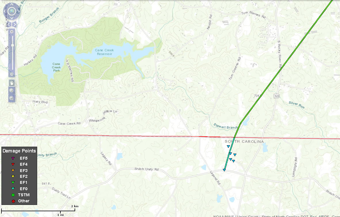
Estimated Time:                4:19 PM
Maximum EF-Scale Rating:       EF1
Estimated Maximum Wind Speed:  100 mph
Maximum Path Width:            50 yards
Path Length:                   8 miles
Fatalities:                    0
Injuries:                      0
Click image for larger view
...Summary...
The National Weather Service in Columbia has confirmed a tornado northeast
of Lancaster in Lancaster County South Carolina on 05/24/2017.

A tornado touched down northeast of Lancaster close to the North
Carolina State Line near Shiloh Unity Road. The tornado continued
northward causing EF-0 damage to crops and trees near Locker Road.
The tornado was in Lancaster County for 0.5 miles having a path
width of no more than 50 yards. The maximum wind speed during this
time was 75 mph.

The tornado moved across the state line and tracked northeast for
over 7 miles. Most of the damage was to trees but a few
structures were damaged. The most significant damage was to a barn
that had the sides and much of the roof torn off. This area
received a rating of EF-1 with maximum winds speeds of 100 mph.
EF0...Weak......65 TO 85 mph
EF1...Weak......86 TO 110 mph
EF2...Strong....111 TO 135 mph
EF3...Strong....136 TO 165 mph
EF4...Violent...166 TO 200 mph
EF5...Violent...>200 mph