Summary of the Great Falls, SC EF-2 Tornado on May 5th 2020
| Location | Estimated Start Time | Maximum EF-Scale Rating | Estimated Maximum Wind Speed | Maximum Path Width | Path Length | Fatalities | Injuries |
|---|---|---|---|---|---|---|---|
|
Great Falls, SC |
06:45 PM EDT |
EF-2 |
115 mph |
200 yards |
14.24 miles |
0 |
0 |
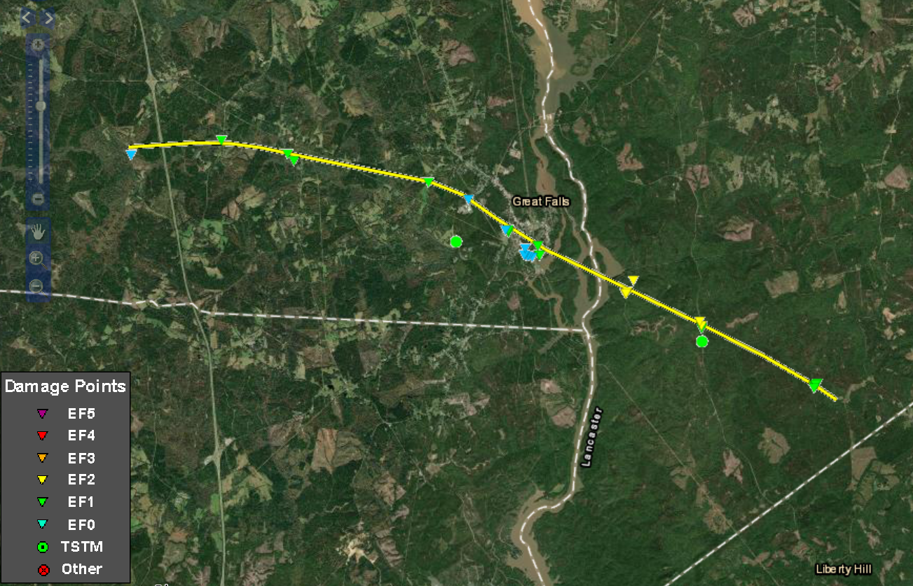
...NWS DAMAGE SURVEY FOR 05/05/20 TORNADO EVENT...

...Great Falls EF-2 Tornado in Chester and Lancaster Counties...

Start Location...7 W Great Falls in Chester County SC
End Location...7 ESE Great Falls in Lancaster County SC
Date...05/05/2020
Estimated Time...06:45 PM EDT
Maximum EF-Scale Rating...EF2
Estimated Maximum Wind Speed...115 mph
Maximum Path Width...200.0 yards
Path Length...14.24 miles
Beginning Lat/Lon...34.5925 / -81.0262
Ending Lat/Lon...34.5246 / -80.7958
* Fatalities...0
* Injuries...0

...Summary...
National Weather Service Storm Survey Teams from the offices in
Greenville-Spartanburg and Columbia, SC have confirmed a tornado
began in southeastern Chester County and dissipated in
southwestern Lancaster County. The tornado produced winds up to
115 mph, which is an EF-2. The path length was just over 14 miles
and path width was approximately 200 yards at its widest point.

The tornado began west of Great Falls in Chester County, near Old
Catholic Church Road. The tornado then moved east, crossed
Interstate 77, and produced damage across Mountain Gap Road, Ross
Dye Road and Georgetown Road, before turning southeast toward the
town of Great Falls. The tornado crossed Highway 21 and produced
damage in areas including Walnut Street, Hampton Street, Duke
Street, and Republic Street. Estimated winds were up to 105 mph in
Chester County, based on large trees being uprooted or snapped.
In addition, a house on Republic Street was destroyed when a tree
fell on it.

The tornado strengthened as it crossed the Catawba River and
entered southwestern Lancaster County. The tornado moved
southeast, producing significant tree damage, with numerous large
hardwood and softwood trees uprooted or snapped. The most
significant damage occurred between Green Road and Cedar Creek
Road near Mount Carmel Road, where estimated winds were up to 115
mph. A tree also fell on a vehicle on Cedar Creek Road. The
tornado then crossed Cunningham Quarters Road, before dissipating
near Mable Anthony Road.

This supercell thunderstorm also produced large hail up to Golf
Ball size in Chester and Lancaster Counties, and later up to
Tennis Ball size in Bethune in northern Kershaw County.

EF Scale: The Enhanced Fujita Scale classifies tornadoes into the
following categories:

EF0...Weak......65 to 85 mph
EF1...Weak......86 to 110 mph
EF2...Strong....111 to 135 mph
EF3...Strong....136 to 165 mph
EF4...Violent...166 to 200 mph
EF5...Violent...>200 mph

* The information in this statement is preliminary and subject to
change pending final review of the event and publication in NWS
Storm Data.

