
Dangerous and extreme heat will remain across portions of the southern U.S. through the weekend. A heat wave over the Southwest U.S. will intensify this week, peaking and expanding into the Intermountain West and northern High Plains this weekend. Multiple rounds of thunderstorms will produce heavy to excessive rainfall with significant flash flooding across portions of southern New England. Read More >
Billings, MT
Weather Forecast Office
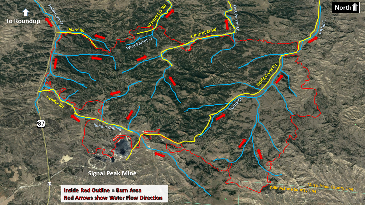
BobCat Burn Area – Flash Flood/Debris Flow Information
 |
*** This includes portions of the Bull Mountains east of US-87 to just east of Fattig Creek*** |  |
| KMZ File PDF Briefing PDF Handout Brochure |
Flash Floods and Debris Flows will quickly inundate streams, channels, and low-lying areas.
Remain aware of the environment around you.
If rainfall is occurring in or upstream of your location, and you are in or near a burned area,
You Are at Risk!
Specific Locations at Risk
Populated Locations
Subdivisions within the Burn Perimeter
Residences along creeks/streams/coulees downstream to the Musselshell River
Roads
US-87, Fattig Creek Rd, East Parrot Creek Rd, West Parrot Creek Rd, Rehder Rd,
Bruner Mountain Rd, Beard Rd
Rivers/Streams
Halfbreed Creek, Fattig Creek, East Parrot Creek, West Parrot Creek, Rehder Coulee
Frequency of Potential Flooding Rainfall Events for this Burn Scar:
Average of 5 events per year
US Dept of Commerce
National Oceanic and Atmospheric Administration
National Weather Service
Billings, MT
2170 Overland Ave
Billings, MT 59102-6455
(406) 652-0851
Comments? Questions? Please Contact Us.

