Lake Effect Summary - January 27, 2016
|
|
|
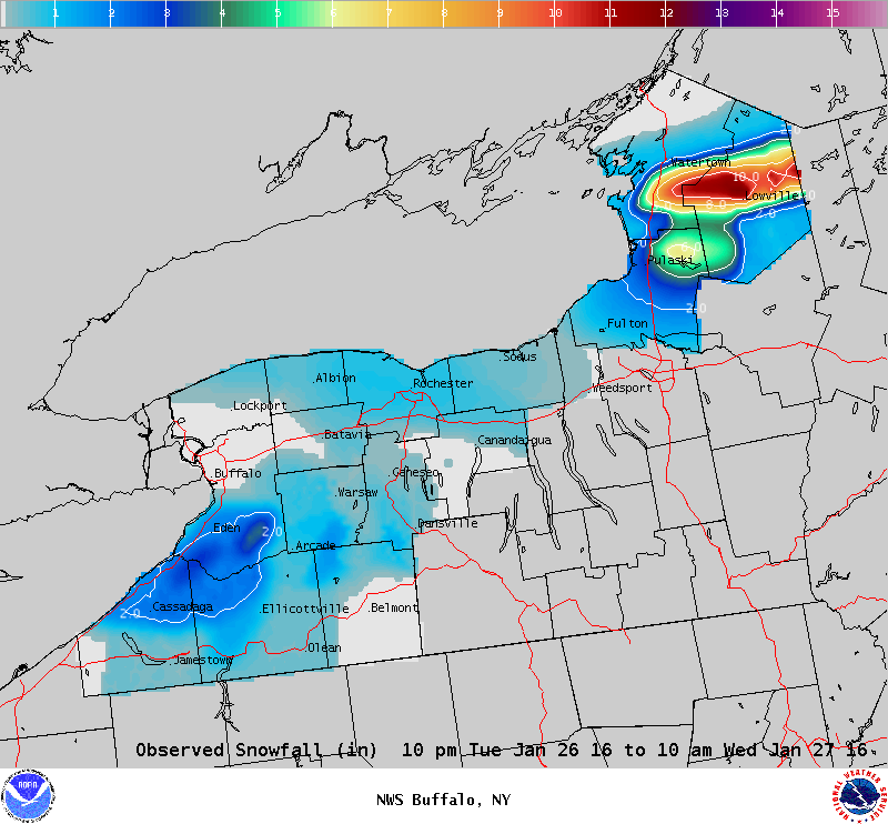
Maximum Snowfall: Lake Erie 3.8" (Glenwood); Lake Ontario 11.5" (Lowville) Duration: 12 hours +/- Flake Scale: 1 flake * Our 7th lake effect snow event of the year was a narrow band of snow that focused brief, but heavy lake effect snow east of Lake Ontario. A cold front crossed the Northeast on Tuesday, January 26th, sending air temperatures downward, and increasing the instability over the lake waters. As temperatures dropped to near -10C at 850 hPa, lake effect snow developed in the early morning hours of Wednesday, January 27th. Off of Lake Erie broad bands of snow brought several inches of snow across the hills south of Buffalo, with the bulk of the snow falling just before and during morning rush hour on Wednesday the 27th of January. East of Lake Ontario the westerly flow brought a narrow, 10 to 15 mile wide, band of lake effect snow inland across the North Country. A secondary cold front approaching the northern shoreline of Lake Ontario Wednesday morning brought enhanced convergence, and allowed this band of snow to produce snowfall rates of up to 2 inches per hour. This brought a narrow swath of one half to one foot of snow east of Lake Ontario. As the band of snow reached peak intensity, several flashes of lightning were seen over southern Jefferson and western Lewis counties between 630 and 730 am. Winds quickly veered to northwesterly, with this wind direction pushing the lake effect snow to along the southern Lake Ontario shoreline. As warm air advection began in the mid levels, the already marginal instability over the lakes vanished, resulting in an end to the lake effect snow off Lake Erie during the late morning hours of Wednesday, and afternoon hours of Wednesday off Lake Ontario. Highest impacts from this event were generally confined to a narrow stretch east of Lake Ontario Wednesday morning. Given the brief nature of this event and low end warning snowfall amounts, one flake will be given to the lake effect snow. Here are some representative snowfall totals for this event:
|