Lake Effect Summary - December 26-27, 2013
|
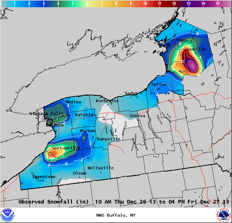
Maximum Snowfall: Lake Erie 10.5" (Perrysburg); Lake Ontario 20" (Lorraine)
Duration: 30 hours +/-
Prime feature: Hybrid synoptic and marginal lake effect.
The fifth lake effect storm of the season was very similar to the fourth in that an upper level trough crossed the region on Thursday the 26th and brought a light snow across the region. Following this trough, light lake enhanced snow developed off Lake Erie across the northern Niagara Frontier and off of Lake Ontario over Jefferson County.
A more pure lake effect snow band developed later Thursday off both lakes, forming from marginal lake instability, equilibrium levels around 7,000 feet and trailing moisture behind the upper level trough. A westerly flow drove these lake bands across the ski country east of Lake Erie, and across the Tug Hill region off Lake Ontario.
Much of the snow east of Lake Erie fell through the overnight hours Thursday night. The snow band off Lake Ontario produced snowfall rates of 2 to 3 inches per hour near the Jefferson/Oswego county border and inland towards Lewis County. This band fell apart in the predawn hours Friday, but reorganized across the Tug Hill region Friday morning to complete the lake effect event.
Snow totals from this event were about 6 inches or less off Lake Erie, though a few spots in the hills south of Buffalo picked up additional snow accumulation. The greatest snow totals east of Lake Ontario were found over the Tug Hill region where around a foot and a half of snow fell.
|
Off Lake Erie...
10.5 inches... Perrysburg
6.0 inches... Cassadaga
5.5 inches... Machias
4.7 inches... Glenwood
4.3 inches... Williamsville
|
Off Lake Ontario...
20.0 inches... Lorraine
15.6 inches... Highmarket
11.8 inches... Hooker
8 inches... Lacona
6 inches... Pulaski
|
|