October 2021 Roars Into Cameron County With Record Rainfall, Widespread Flooding
Brownsville to Harlingen Shatter Single-Day Records on the 1st; Flash Flooding From Harlingen to Brownsville
Overview
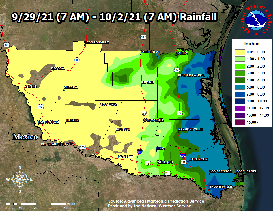
The combination of an upper level disturbance crossing the southern Great Plains, upper level wind and a low level low pressure system moving east from Nuevo Leon, Mexico, and prior boundaries from earlier thunderstorms north of the Rio Grande Valley and from morning thunderstorms along the coast combined with deep atmospheric tropical moisture to create a thunderstorm "system", including a heavy-precipitation "supercell" event, along the IH-69E corridor in Cameron County from Harlingen to Brownsville, including San Benito, Rio Hondo, and Los Fresnos. Measured and estimated rainfall of 4 to 8 inches in just two hours or so was too much for many drainage systems to handle, and significant flash flooding occurred during the peak of the October 1st (Friday afternoon) late afternoon and evening commute. The peak of the heavy rainfall occurred between 330 and 7 PM, with some locations in east and northeast Brownsville receiving 7 to 8 inches in two hours or so within that window. Additional heavy rainfall of 5 to 9 inches (radar and observed) fell mainly in rural eastern Willacy and Kenedy Counties on September 30 and October 1.
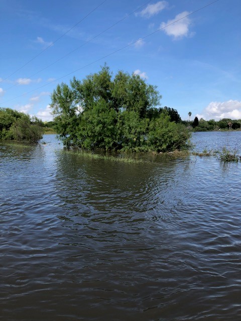
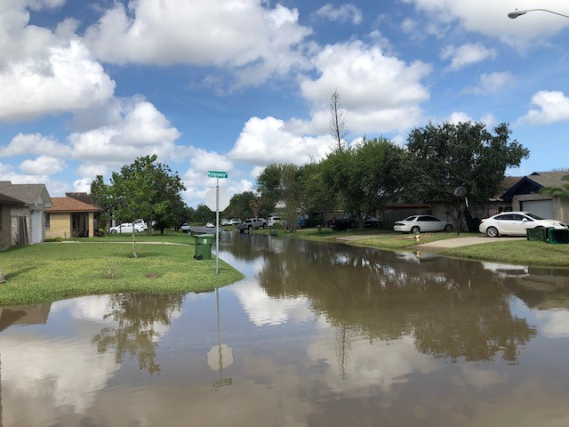
Flooding was most intense to the east and northeast of downtown Brownsville during the late afternoon and well into the evening of October 1. During the peak of the event, hundreds of streets were impassible, hundreds of vehicles became trapped in the high water, with many partially submerged and others totally submerged. Hundreds of residences sustained some damage from the floodwaters, which ranged from inches to more than a foot indoors. All resacas and retention ponds in this area were at or even just above bank full late on October 1, with at least one just north of Boca Chica Blvd. on Vermillion Ave. over spilling onto the road well into the following day (Oct. 2, above). Many harvested fields were filled with water in Cameron County between Brownsville, Los Fresnos, and Rio Hondo. Based on first-hand reports from residents and law enforcement, peak water depth in streets, parking lots, and other locations ranged from "waist to chest high" - 3 to more than 4 feet. The highest levels were where water pooled, such as toward the edges (curbs, rightmost lanes, etc). On October 2, County Judge Eddie Trevino issued a local disaster declaration to account for public and private damage, which was likely to end up in the millions of dollars. Additional damage information will be posted to this site later this autumn.
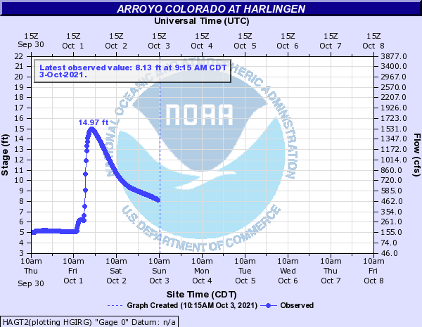
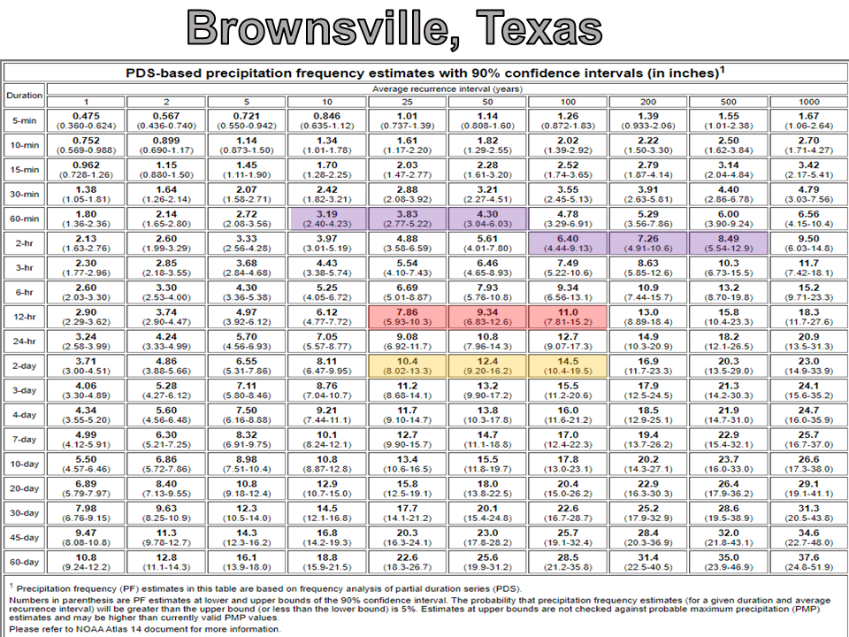
The torrential rain in Harlingen spiked the flows in Arroyo Colorado, with a peak level of 14.97 ranking 8th highest on the historical record (below), and just below the most recent October Rio Grande Valley flood events in late October, 2015.
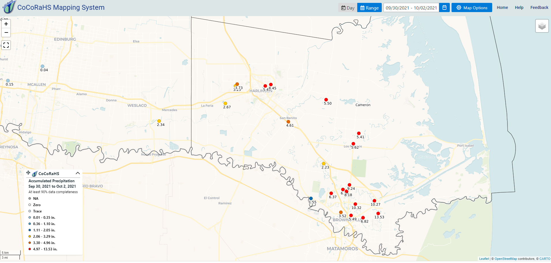
The localized nature of the rainfall was more common with an event on August 31, 2015 (Cameron County), and October 30, 2015 (Cameron, Willacy) than those in recent years (most of the populated Rio Grande Valley). While Cameron County generally received 3 to more than 13 inches of rain in two calendar days, the McAllen metro area received less than 1 inch.

Event Data in Context
Combined with earlier heavy rainfall from bands that slid across east Brownsville to Harlingen, daily totals in both locations shattered prior records. The single-day rainfall also ranked near the top for October overall, as well as for the calendar year, at both locations. Combined with a separate early morning event the prior day (September 30), total rainfall was a high as 13.53 inches (see map, below) fell just north of the NWS Office in East Brownsville - a total that is roughly 4 inches above the average for September and October combined. In just two calendar days! A preliminary list of these and other observations is shown at the end of this document. Specific points of note include:
Rainfall Data and Historical Return Frequency
In areas of east and northeast Brownsville where flooding was most intense, the estimated hourly and multi-hourly rainfall rates were likely well beyond the specified drainage capacity, based on return frequencies in specific locations. The combination of observed rainfall during the heavy-precipitation supercell portion (generally between 430 and 7 PM in east and northeast Brownsville) suggested hourly rainfall rates of 3 to 4 inches for up to two hours. These short-term totals match closely with 1 in 100 to 1 in 500 annual probability events, also known as "100 to 500 year" floods. Single-hour rates were a bit less but still impressive, ranking between 1 in 10 and 1 in 50 probabilities ("10 to 50 year" floods). The 12-hour, single-day, and 2-day return frequencies ranged from 1 in 25 to nearly 1 in 100 ("25 to 100 year" floods). Bottom line? Even if neighborhood drainage capacity was rated for the "100 year" flood, the 2-hour rainfall rates overwhelmed said systems - and widespread flash flooding was inevitable.
Video
Two videos were provided to our office by Jim Danner, Broadcast Meteorologist from KGBT Channel 4, of ongoing flooding just before sunset Friday, October 1, along Paredes Line Road northeast of downtown Brownsville.
Video 1: Resaca and nearby thoroughfares in the Paredes Line/Morrison Road area of Northeast Brownsville
Video 2: Paredes Line Road with hundreds of vehicles under feet of water, many stranded
Preliminary 3-Day Rainfall Totals, Valley-Wide
Below is a list of rainfall from multiple sources, collected on October 2nd. Note that some of these may not match mapped data due to automated collection methods.
...UPDATED PRECIPITATION REPORTS FROM 10 PM THURSDAY TO MIDNIGHT SATURDAY...

Location                     Amount    Time/Date       Provider

...Texas...

...Brooks County...
Falfurrias                   1.25 in   0115 AM 10/02   AWOS

...Cameron County...
Brownsville 4.1 E            10.72 in  0800 AM 10/02   COCORAHS
Brownsville 6.4 SE           9.45 in   0700 AM 10/02   COCORAHS
Brownsville 1.7 NNE          9.34 in   0700 AM 10/02   COCORAHS
Harlingen 1.1 NE             8.41 in   0800 AM 10/02   COCORAHS
Brownsville 4.1 ENE          8.40 in   0800 AM 10/02   COCORAHS
Brownsville                  8.09 in   0953 AM 10/02   ASOS
1.0 NE Harlingen             7.97 in   0700 AM 10/02   COOP
Brownsville 4.4 N            7.95 in   0800 AM 10/02   COCORAHS
Brownsville 3.5 N            7.45 in   0800 AM 10/02   COCORAHS
Brownsville 12.6 E           6.23 in   0700 AM 10/02   COCORAHS
Brownsville 1.9 ESE          6.15 in   0800 AM 10/02   COCORAHS
Harlingen                    6.11 in   1252 AM 10/02   ASOS
Brownsville 3.9 NNW          5.86 in   0700 AM 10/02   COCORAHS
San Benito 6.3 ENE           5.50 in   0700 AM 10/02   COCORAHS
Brownsville 0.4 WSW          5.50 in   0902 AM 10/02   COCORAHS
Harlingen 0.4 N              5.45 in   0800 AM 10/02   COCORAHS
Los Fresnos 0.3 NE           4.99 in   0700 AM 10/02   COCORAHS
Brownsville 0.1 SSE          4.93 in   0700 AM 10/02   COCORAHS
Los Fresnos 2.1 NNE          4.89 in   0708 AM 10/02   COCORAHS
Los Frenos                   4.63 in   0907 AM 10/02   CWOP
San Benito 0.9 SSE           4.52 in   0700 AM 10/02   COCORAHS
Port Isabel                  4.05 in   0953 AM 10/02   ASOS
Laguna Atascosa              3.95 in   0922 AM 10/02   RAWS
Harlingen 4.2 W              3.73 in   0700 AM 10/02   COCORAHS
Brownsville 1.5 WNW          3.45 in   0700 AM 10/02   COCORAHS
Harlingen 4.4 W              3.23 in   0700 AM 10/02   COCORAHS
Los Fresnos                  3.12 in   0646 PM 10/01   CWOP
Laguna Vista 0.3 N           3.04 in   0700 AM 10/02   COCORAHS
Los Fresnos                  3.02 in   0956 AM 10/02   CWOP
Harlingen 6.2 WSW            2.65 in   0700 AM 10/02   COCORAHS
La Feria                     2.57 in   1010 AM 10/02   CWOP
Laguna Vista                 2.52 in   0101 AM 10/02   CWOP
Brownsville                  2.10 in   1001 AM 10/02   CWOP
Rancho Viejo 0.7 E           1.75 in   0700 AM 10/02   COCORAHS
Brownsville 6.4 WNW          1.55 in   0830 AM 10/02   COCORAHS

...Hidalgo County...
Mercedes 1.9 SW              2.32 in   0800 AM 10/02   COCORAHS
Weslaco Midvally             2.24 in   0955 AM 10/02   AWOS
RIO GRANDE NWR EDINBURG 17 N 2.14 in   0910 AM 10/02   HADS
Edinburg Intl                1.84 in   1015 AM 10/02   AWOS
1.4 NE Weslaco               1.81 in   0700 AM 10/02   COOP
Linn-San Manuel              0.54 in   0946 AM 10/02   RAWS
Edinburg                     0.51 in   1010 AM 10/02   CWOP
Santa Ana Nwr                0.29 in   0945 AM 10/02   RAWS
McAllen 3.5 N                0.15 in   0700 AM 10/02   COCORAHS
3.0 W Santa Rosa             0.10 in   0700 AM 10/02   COOP
Edinburg                     0.10 in   0700 AM 10/02   COOP
Mccook                       0.06 in   0700 AM 10/02   COOP
McAllen 2.4 NE               0.04 in   1201 AM 10/02   COCORAHS
McAllen                      0.04 in   1005 AM 10/02   CWOP
7.3 S Alamo                  0.03 in   0945 AM 10/02   HADS
Mcallen                      0.01 in   0953 AM 10/02   ASOS

...Jim Hogg County...
18 N La Gloria               0.50 in   0125 AM 10/02   AWS

...Willacy County...
Port Mansfield 1.1 SE        4.00 in   0700 AM 10/02   COCORAHS
1.8 W Raymondville           2.70 in   0800 AM 10/02   COOP

Observations are collected from a variety of sources with varying
equipment and exposures. We thank all volunteer weather observers
for their dedication. Not all data listed are considered official.

