Brownsville/Rio Grande Valley, TX
Weather Forecast Office
Zapata's Midnight Madness: Severe Thunderstorm Rakes City With Widespread Damaging Winds

Overview
A rapidly developing severe thunderstorm crossed the Rio Grande into Zapata County shortly after midnight on May 26. The storm produced damaging straight line winds across much of the city of Zapata, including portions of Medina Addition to the east and Sierra Shores to the south.
Widespread damage was surveyed across the city with more than two dozen single wide mobile and manufactured homes having partial or total roof damage. Nearly all of the critically damaged infrastructure was of poor and older construction. An unknown number of families were temporarily displaced by the storms, whose winds and rain damaged most contents where nearly all of the roof was torn off. Many of these homes were uninhabitable with significant water and wind damage. At least half a dozen poorly built businesses suffered partial or total roof damage. Most of these structures saw initial roof uplift at the northwest corner of the overhangs with full exposure to the wind. Several un-anchored trailers, recreational vehicles, and sheds were also rolled over.
More than a dozen wooden utility poles were leaning or broken, most of which had wet or rotting bases. Hundreds of healthy large tree branches were blown down, in addition to dozens of uprooted trees with shallow root systems. Three light stanchions near the County Courthouse were blown over. Also, many business signs were blown out, and two brick displays were toppled. The extent of damage was likely to range in the millions of dollars.
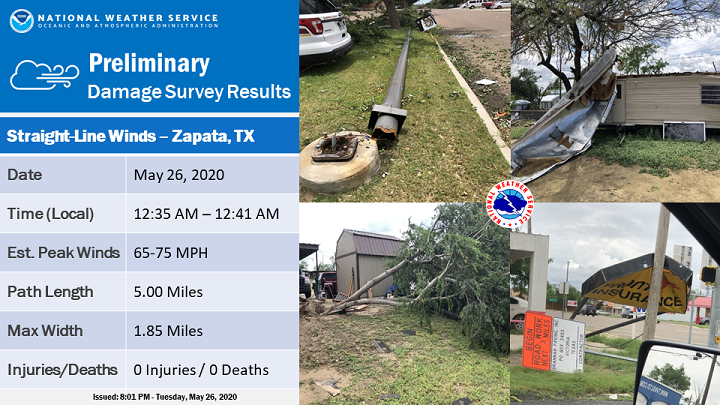
A preliminary summary of estimated wind speed, path length, and path width, follows:
Estimated Peak Wind:    65 to 75 MPH
Path Length (Statute):  5.00 Miles
Path Width (Maximum):   1.85 Miles
Fatalities:             0
Injuries:               0

Start Date:             May 26, 2020
Start Time:             12:35 AM CDT
Start Location:         1.00 miles northwest of Zapata
Start LAT/LON:          26.9207/-99.2802

End Date:               May 26, 2020
End Time:               12:41 AM CDT
End Location:           3.90 miles south of Zapata
End LAT/LON:            26.8513/-99.2587
Additional photos will be added to this page as time permits. For now, you can view them through the NOAA/NWS Storm Damage Viewer. To do so, you'll need to install and activate Adobe Flash Player. Then, zoom the map into Zapata City, and click on one of fifty small green dots to get individual damage reports and on-site damage photos.
CURRENT HAZARDS
Daily Briefing (National)
Outlooks
Severe Weather Text
Local Storm Report
Submit a Storm Report
CURRENT CONDITIONS
Surface Observations (map)
Text Observations
Satellite
Rivers and Lakes
Observed Precip - RGV
Tides and Currents
CoCoRaHS Texas
FORECASTS
Forecaster's Discussion
Graphical
Hourly View
Activity Planner
Marine
South Padre Tides
Wave Prediction
Beach
Surf
Fire Weather
Aviation
Tropical
Winter Storm Severity Index
Model Guidance
US Dept of Commerce
National Oceanic and Atmospheric Administration
National Weather Service
Brownsville/Rio Grande Valley, TX
20 S. Vermillion Avenue
Brownsville, TX 78521
956-504-1432 (8 AM to 430 PM Mon-Fri)
Comments? Questions? Please Contact Us.

