Long-Track Supercell Thunderstorm Produces Wind Damage, Hail in Willacy and Northeast Cameron
Residents of Raymondville, San Perlita, Santa Monica, and Arroyo City Pounded Just After Daybreak April 4, 2020
Overview
A small but potent supercell thunderstorm formed in southern Jim Hogg County during the pre-dawn hours of April 4th, feeding off just enough unstable air and turning low level winds ahead of a cold front to roll across the Ranchlands of northern Hidalgo County, across Willacy County from northwest of La Sara to the Cameron County line east of Santa Monica, exiting into the Gulf east of Arroyo City in Cameron County. The supercell showed a persistent hail core and microburst signature while over the rural ranchlands, which continued as it moved into farming communities of Willacy County. In Raymondville, a power pole was snapped on north 7th Street, but more significant damage was noted along State Highway 186, with more than two dozen power poles felled, broken, or leaning on the highway and surrounding Farm to Market Roads. A poorly constructed home was partially destroyed in San Perlita; a number of medium to large mesquite and other hardwood branches were snapped, and hailstones between 1 and 2 inches in diameter fell between San Perlita and Arroyo City. Peak wind from an NWS storm survey was estimated at 70 mph in and near San Perlita, with strong gale-force gusts on Laguna Madre just before 10 AM. A reported instance of wind-driven hail may have been the cause for flattened crops in the area. Torrential rains accompanied the storm, flooding newly planted fields with up to a foot of water depth. Rainfall estimates under the core of the storm were 2 to 3 inches within 30 to 45 minutes.
The Public Information Statement with path length/width details is shown below, as is a graphic including damage photos. A map of damage points can be found here. Need Flash? Download Flash Player here.
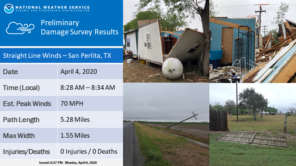
PUBLIC INFORMATION STATEMENT
NATIONAL WEATHER SERVICE BROWNSVILLE TX
727 PM CDT Sat Apr 4 2020

...NWS DAMAGE SURVEY FOR 04/04/20 THUNDERSTORM WIND EVENT NEAR
RAYMONDVILLE TEXAS...

.OVERVIEW...A long track supercell thunderstorm that originated
across the South Texas Brush Country ranchlands of Jim Hogg County
during the pre-dawn hours moved steadily to the east, then
southeast, while crossing rural northern Hidalgo County and central
Willacy County before exiting the coast in northeast Cameron County.
In small population centers of Willacy and northeast Cameron County,
a combination of damaging straight line wind and large hail was
reported.

.THUNDERSTORM WIND 1...

PEAK WIND /E/:          70 MPH
PATH LENGTH /STATUTE/:  5.28 MILES
PATH WIDTH /MAXIMUM/:   2728 YARDS
FATALITIES:             0
INJURIES:               0

START DATE:             APR_04_2020
START TIME:             0828_AM_CDT
START LOCATION:         3.8 MILES SW OF SAN PERLITA_/_WILLACY_/_TX
START LAT/LON:          26.4827_/_-97.6959

END DATE:               APR_04_2020
END TIME:               0834_AM_CDT
END LOCATION:           2.72 MILES SOUTHEAST OF SAN PERLITA_/_WILLACY_/_TX
END LAT/LON:            26.4810_/_-97.6108


.SURVEY SUMMARY...
A supercell thunderstorm rolled through central and southeastern
Willacy County a little more than an hour after sunrise, and
produced damaging winds near San Perlita and on nearby ranches
around 830 AM CDT. One residence in San Perlita, fully exposed to
the northwest, sustained significant damage when its poorly
constructed roof lifted off.  The residence was a mobile home with a
separate addition on a pier/block foundation. The addition had
significant drywall and contents damage due to rainfall and wind,
though the walls remained standing. The original mobile trailer
sustained only minor damage to soffiting on its northwest side.
Construction of the entire unit was fair to poor, and there was no
damage to a church across the street which was also fully exposed to
the strong winds. The survey team rated winds of 70 mph at this
location.

Nearby damage was noted along an 5.28 mile stretch of State Highway
186, with more than a dozen wooden power poles broken, uprooted, or
leaning. Nearly all of the broken poles showed notable rot at the
breakpoint, and others were only anchored in shallow soil. In total,
county Emergency Management mentioned a total of 26 poles were
damaged. Within the area of power pole damage was damage to an old
and poorly constructed fence, as well as several small to medium
sized mesquite limbs blown down. Wind speeds in this area were
estimated to be 55 to 65 mph.

Hail also accompanied the winds in and near San Perlita. The family
at the destroyed residence estimated hail the size of quarters or
larger, and hail of unknown size driven by the strong winds
flattened an area of newly planted crops just north of the highway.
Farther southeast (not surveyed), video reports indicated 1.75 inch
diameter hail in Santa Monica (Willacy) and near Arroyo City
(Cameron County).


NOTE:
THE INFORMATION IN THIS STATEMENT IS PRELIMINARY AND SUBJECT TO
CHANGE PENDING FINAL REVIEW OF THE EVENTS AND PUBLICATION IN
NWS STORM DATA.

