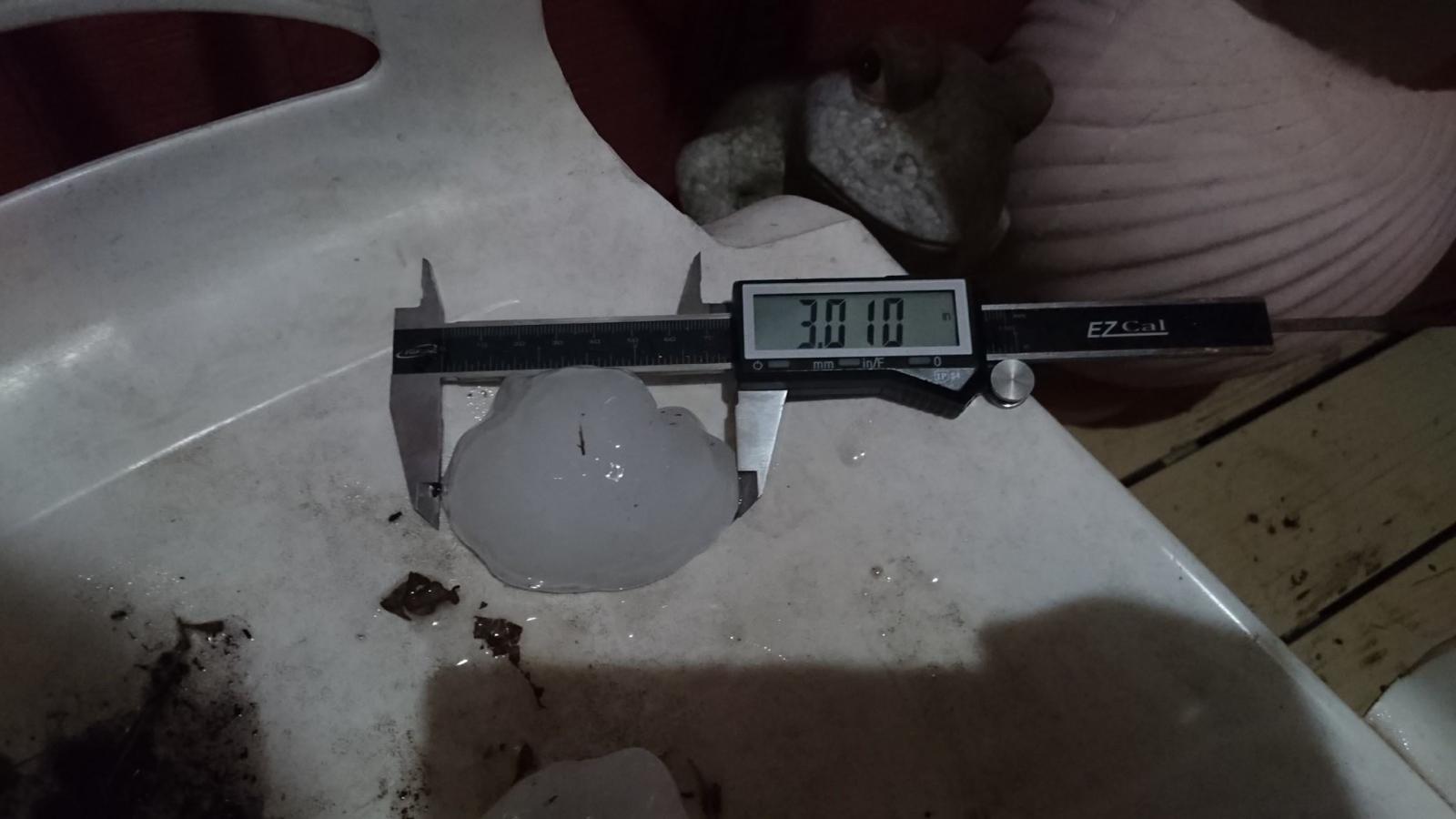
 Measured hailstone at just over 3 inches in diameter in southwest Rio Hondo, Texas, during the mid evening of April 2, 2017. Photo courtesy of Mr. Johnathan Cerda. |
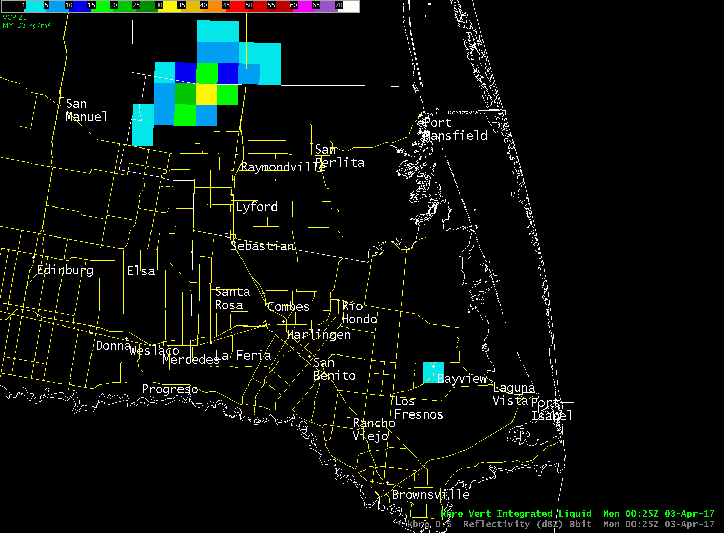 Loop of the legacy radar product Vertically Integrated Liquid (VIL), an estimate of the total mass of precipitation in a thunderstorm. Values >70 kg/m2 in a supporting air mass can correlate with golfball sized hail; ≥80 kg/m2 can correlate with baseball sized hail or larger. |
| No Foolin’! Hail of a Night in Lower Valley April 2nd Hailstorm Brings Largest Diameter Stones in Nearly Five Years |
|
|
After a hazy, lazy, summer–like Sunday across the Rio Grande Valley, where afternoon temperatures once again surged into the 90s but high humidity made it feel closer to 100°F, a very unstable atmosphere was triggered just after sunset by the combination of weak surface convergence, aided by a light easterly flow near the coast, and the approach of the tail of an upper level disturbance which provided the "nudge" the atmosphere needed. Within a half hour (between 730 and 8 PM), scattered severe thunderstorms exploded high into the atmosphere from the Yturria Ranch in southeast Kenedy County into extreme northern Willacy County. As the initial storms waned, southward moving boundaries from them converging with very unstable air in central Willacy County fired off another severe storm, whose updraft supported and sustained hail the size of quarters to golfballs along State Highway 186 from near La Sara through Raymondville, San Perlita, and Port Mansfield. The final explosive development of the evening, shortly before 9 PM, began between La Feria and Harlingen and would soon bring quarter to golfball sized hail to the north half of Harlingen, from near Bass Boulevard north of Interstate 2 eastward to Loop 499 and Valley International Airport; a second round would form on the rear flank of the initial storm and drop another round of smaller hail 15 to 30 minutes later over some of the same areas. The first Harlingen cell peaked in Rio Hondo, 7 miles east of Harlingen, between 905 and 920 PM where hailstones up to 3.5 inches in diameter fell. In all, dozens of vehicles in each storm sustained damage from cracked windshields and dinged or dented exteriors; as of this writing, an unknown number of roofs were likely impacted mainly in Rio Hondo from the impressively large stones. Damage totals in all areas will be calculated over the next several months after local assessments are conducted. What the Hail? Some Reasons for the Wild Evening  Atmospheric sounding at Brownsville/South Padre Island International Airport, taken between 6 and 630 PM (posted by 7 PM CDT) April 2. Note the very unstable red shaded area, as well as the "Sig Hail" index. Sig Hail index does not correlate to hail size, but values over 2 indicate the potential for large to very large stones if a lifting mechanism is available. |
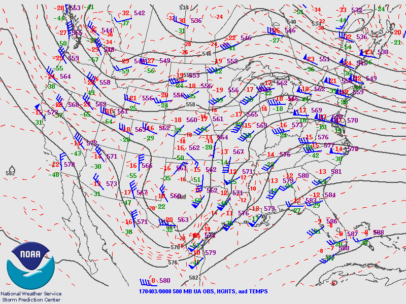 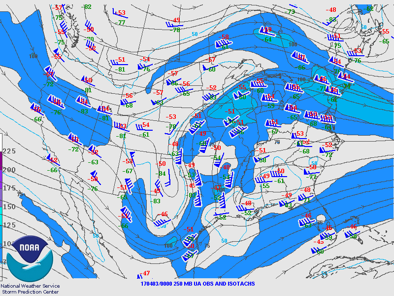 Top: 500 millibar (~18,000 feet) atmospheric flow pattern across the United States. Strong upper level low through north Texas spawned large tornadoes in Louisiana during the afternoon; a weaker disturbance along the trough axis was one likely culprit in helping develop the hailstorms in the Lower Valley that evening. Bottom: 250 millibar (~27,000 feet) atmospheric flow pattern across the United States. Blue shades are stronger wind fields; a small nose of 100 knot winds was approaching the Lower Rio Grande Valley and likely assisted divergence of air necessary to allow strong updrafts to develop that led to the hailstorms. The Rio Hondo hailstorm is shown in three dimensions, below (center). Note the "overhang" of precipitation above lower reflectivity near the surface, a sign of the suspended updraft. Also not the concentration of a likely combination of hail and supercooled water well above the freezing layer; reflectivity above 65 dbZ was noted at nearly 25,000 feet, with 50 dbZ above 40,000 feet. Fortunately, these cells did not dwell and were pushed along by healthy winds (see the wind barbs in the sounding at left) that kept hail accumulation low, a far cry from the slow moving supercell that wracked McAllen earlier in 2012 (March 29th) with more than $600 million in insured damage as of 2016. A few hail storms even formed right along the 500 mb trough axis itself, with penny sized hail reported near midnight in Mission (see report listing and map below). Soon after midnight, the trough axis whipped by and dry air arrived, leading to a gorgeous Monday to begin the first full work week in April 2017. Thanks to our numerous social media followers who provided dozens of photos and stories of this hail event. For others not on social media, you can track the photos on our Facebook Page here. |
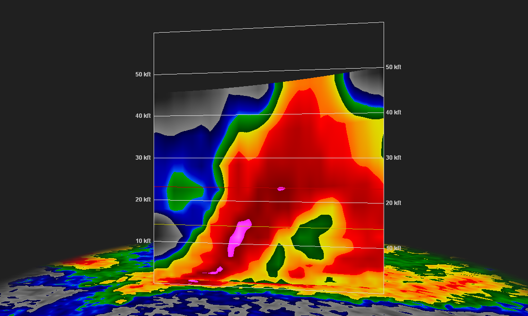 Three dimensional cross section of reflectivity as large hail, up to 3.5" in diameter, fell on Rio Hondo. Note the pink areas, much of which is above the freezing level, and the height of the red area also well above the freezing level – as well as the lower reflectivity (overhang) near the surface. The pink indicates ice and water reflectivity at high concentration, one indicator of large hail formation.  Loop of base reflectivity at 1.8° elevation for the span of the Lower Rio Grande Valley hail event. Where reflectivity colors turn pink, hail the size of quarters to baseballs (and larger) fell soon after.  Preliminary map of hail reports from the Rio Grande Valley during the evening of April 2, 2017. Map courtesy of Iowa State University
725
NWUS54 KBRO 031706
LSRBRO

PRELIMINARY LOCAL STORM REPORT...SUMMARY
NATIONAL WEATHER SERVICE BROWNSVILLE TX
1203 PM CDT MON APR 03 2017

..TIME...   ...EVENT...      ...CITY LOCATION...     ...LAT.LON...
..DATE...   ....MAG....      ..COUNTY LOCATION..ST.. ...SOURCE....
            ..REMARKS..

0858 PM     HAIL             PORT MANSFIELD          26.55N  97.43W
04/02/2017  E1.75 INCH       WILLACY            TX   EMERGENCY MNGR

            GOLF BALL SIZE HAIL REPORTED IN PORT MANSFIELD.

0903 PM     HAIL             HARLINGEN               26.20N  97.69W
04/02/2017  E1.75 INCH       CAMERON            TX   PUBLIC

            GOLF BALL SIZE HAIL IN NORTH HARLINGEN AT THE
            INTERSECTION OF 7TH STREET AND VINSON.

0903 PM     HAIL             1 WNW PALM VALLEY       26.21N  97.77W
04/02/2017  E1.25 INCH       CAMERON            TX   NWS EMPLOYEE

            ESTIMATED HALF DOLLAR SIZE HAIL. HAIL LASTED FOR 8 TO
            10 MINUTES.

0905 PM     HAIL             RIO HONDO               26.23N  97.58W
04/02/2017  E2.75 INCH       CAMERON            TX   LAW ENFORCEMENT

            RIO HONDO POLICE DEPARTMENT REPORTS WINDSHIELDS OF 4
            VEHICLES IN POSSESSION OF CITY OF RIO HONDO BROKEN DUE
            TO HAIL. VEHICLES PARKED AND STATIONARY WHEN DAMAGE
            OCCURRED. HAIL SIZE DETERMINED FROM SOCIAL MEDIA POSTS.

0909 PM     HAIL             HARLINGEN               26.20N  97.69W
04/02/2017  M1.00 INCH       CAMERON            TX   OTHER FEDERAL

            QUARTER SIZE HAIL REPORTED BY FAA AT HARLINGEN AIRPORT.

0915 PM     HAIL             RIO HONDO               26.23N  97.58W
04/02/2017  M2.50 INCH       CAMERON            TX   PUBLIC

            TENNIS BALL SIZE HAIL REPORT ON SOCIAL MEDIA.

0917 PM     HAIL             1 E MONTE GRANDE        26.27N  97.50W
04/02/2017  E2.50 INCH       CAMERON            TX   PUBLIC

            DAMAGED WINDSHIELDS....DENTED VEHICLES...AND CHICKENS
            KILLED.

0920 PM     HAIL             RIO HONDO               26.23N  97.58W
04/02/2017  M3.01 INCH       CAMERON            TX   PUBLIC

            MEASURED REPORT RECEIVED ON SOCIAL MEDIA. HAIL BROKE
            WINDSHIELD AT RESIDENCE. OTHER WINDSHIELDS BROKEN BY
            HAIL IN NEIGHBORHOOD.

0933 PM     HAIL             1 N HARLINGEN           26.21N  97.69W
04/02/2017  M1.25 INCH       CAMERON            TX   NWS EMPLOYEE

            NWS EMPLOYEE REPORTS HALF DOLLAR SIZE HAIL ON NORTH
            SIDE OF HARLINGEN.

1152 PM     HAIL             BASHAM NUMBER 7 COLONIA 26.25N  98.34W
04/02/2017  E0.75 INCH       HIDALGO            TX   PUBLIC

            HAIL LASTED FOR 1 MINUTE.


&&

EVENT NUMBER BRO1700011 BRO1700012 BRO1700016 BRO1700013 BRO1700007
BRO1700009 BRO1700015 BRO1700010 BRO1700008 BRO1700014

PRELIMINARY LIST OF HAIL REPORTS FROM SEVERE THUNDERSTORMS THAT MOVED
ACROSS THE LOWER RIO GRANDE VALLEY ON SUNDAY EVENING, APRIL 2ND,
2017. UPDATES WILL BE PROVIDED AS NECESSARY.
|
|

