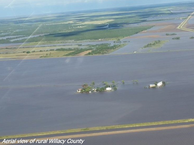
 Photos from urban (Weslaco) and rural (Willacy County) flooding after two bouts of torrential rains dropped more than a foot of rain in each location. Credits: Willacy and Weslaco/Donna/Mercedes Emergency Management, McAllen Monitor, and NWS Brownsville/Rio Grande Valley, KRGV Channel 5, and KGBT Channel 4 Facebook Pages. |
|
| They Needed Noah’s Ark Tropical Moisture, Hurricane Patricia’s Remains Create "Lakes" Willacy and Weslaco We thought this might happen. In October 1997, when the combination of a rapidly strengthening El Niño and an equally strong, positive Pacific Decadal Oscillation was present, the first dozen days of October featured abundant tropical moisture across the Rio Grande Valley, fed by strong and deep (atmospherically) southerly flow that tapped not only the Bay of Campeche but the very warm eastern tropical Pacific Ocean and the remnants of Hurricane Pauline. A strong cold front would arrive on the 13th, which provided the "knockout blow" of additional rains to produce significant water inundation in eastern Cameron County. Ten to fifteen inches of rain fell in Cameron and Willacy County; a brief report on the event can be found here. Fast forward to 2015. While the specific setup was a little different, the outcome was quite similar. After spending much of September of Texas, and keeping tropical moisture (and cyclones) at bay, atmospheric high pressure shifted into the central Gulf and amplified into Mississippi and Ohio Valley during the week of October, as the season’s first strong atmospheric trough slid through the Canadian Maritimes and brought the first freezes and frost to the Mid Atlantic and Northeast U.S. during the weekend of October 17–19. The sprawling, strong surface high that stretched from eastern Canada into the Gulf pushed persistent east/northeast swell across the Gulf, and while fair weather ruled the Rio Grande Valley, the beaches of South Padre Island filled with water during each high tide and began to slowly erode with pounding surf that began the same weekend and continued through October 24th. Perhaps the harbinger of rough weather to come occurred during Wednesday evening, October 21, when a small scale low pressure system just east of Tamaulipas helped ramp up easterly winds for several hours on South Padre Island, gusting to Tropical Storm force at times. The winds, on top of already high seas and surf, created a "mini surge" of tidal flooding into the dunes at South Padre Island, and pushed water along the bayside at Port Isabel to more than 3 feet above Mean Lower Low Water, or nearly 2 feet above ground at the immediate shoreline. The very next afternoon (October 22), as tropical moisture continued to stream north between the amplifying ridge and a slow moving but broad disturbance moving through the southwest U.S., scattered to numerous afternoon thunderstorms mainly along and east of U.S. 77/IH–69E coalesced into a system of storms that flooded rural Willacy County and turned much of the agricultural–rich farmland into a lake. Moisture continued to pool across the Rio Grande Valley on October 23rd; heavy rains formed well north of the region, closer to the better forcing provided by the aforementioned upper level disturbance. However, on Saturday, October 24th, atmospheric puzzle pieces aligned to create some of the highest single event rain totals since Hurricane Dolly in 2008: The upper level disturbance moved into southwest and west Texas, lifting moisture into organized rain bands from Tamaulipas and Nuevo Leon into the Upper Valley and ranchlands by daybreak; the remnants of Hurricane Patricia raced northeast toward the Lower Valley and hooked up with the disturbance as each reached the Lower and Mid Valley, ultimately dumping 5 to 12 inches of rain and putting parts of Weslaco/Donna, Santa Rosa, and much of Willacy County under several feet of water. In the end, thanks to excellent community preparedness and perhaps a little bit of luck, there were no known injuries and zero deaths from the rising water. The National Weather Service salutes our public safety officials and first responders for a job well done before, during, and after perhaps the most impacting weather event, at the time, of the year. The October Flood of 2015 will not soon be forgotten by residents and drivers affected by it. |
|
 "Lake" Willacy? Radar estimated rainfall, showing 6 to 9 inches in a small core near San Perlita, TX, after more than five hours of rain October 22. Round 1, Oct. 22: Willacy Farm Country Goes Under Water Round 2, Oct. 24: From Weslaco to Willacy, Water Water Everywhere 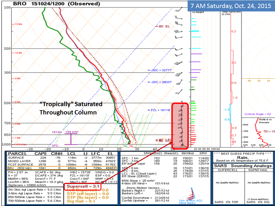 Atmospheric profile at Brownsville, TX, 7 AM October 24, 2015. In addition to the strong southerly winds and shear favorable for "mini–supercells", the moisture filled column value of 2.57 inches was nearly one half inch higher than the prior record for the date (2.10 inches), back to 1948. |
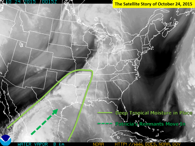
 250 mb flow (~33,000 feet or so) at 7 AM October 24, 2015. The combination of a favorable location for moisture lift east of the southwest Texas/northern Mexico upper disturbance (maroon) and a subtle enhancement by the jet streak associated with the remains of Patricia (orange) fed the deepest moisture into several bands of torrential rain across the Lower Valley during the afternoon. Round 2, Oct. 24: From Weslaco to Willacy, Water Water Everywhere (continued) Insult to Injury: "Lake Willacy" Expands and Deepens Both Hidalgo and Willacy County were readying paperwork for Federal States of Emergency due to the widespread flooding and dozens, if not hundreds, of affected properties. Damage will easily run into the tens of millions of dollars when assessments are complete; final values will be available at a later date. |
 Composite Reflectivity for October 22, 2015, from 358 through 659 PM, the time of the heaviest rainfall. Click for a larger image. |
 Composite Reflectivity for October 24, 2015, centered on the Lower and Mid Rio Grande Valley from 1201 PM through 6 PM, the time of the heaviest rainfall. Click for a larger image. |
 Click for an animation of the 7 PM, October 23, 2015 through 7 PM, October 24, 2015 water vapor (satellite) images that led up to and included the flooding rainfall across the Lower and Mid Valley.  Note: The vast majority of the rainfall shown occurred during the afternoon of October 22nd and from after midnight through just after sunset on October 24th, 2015. 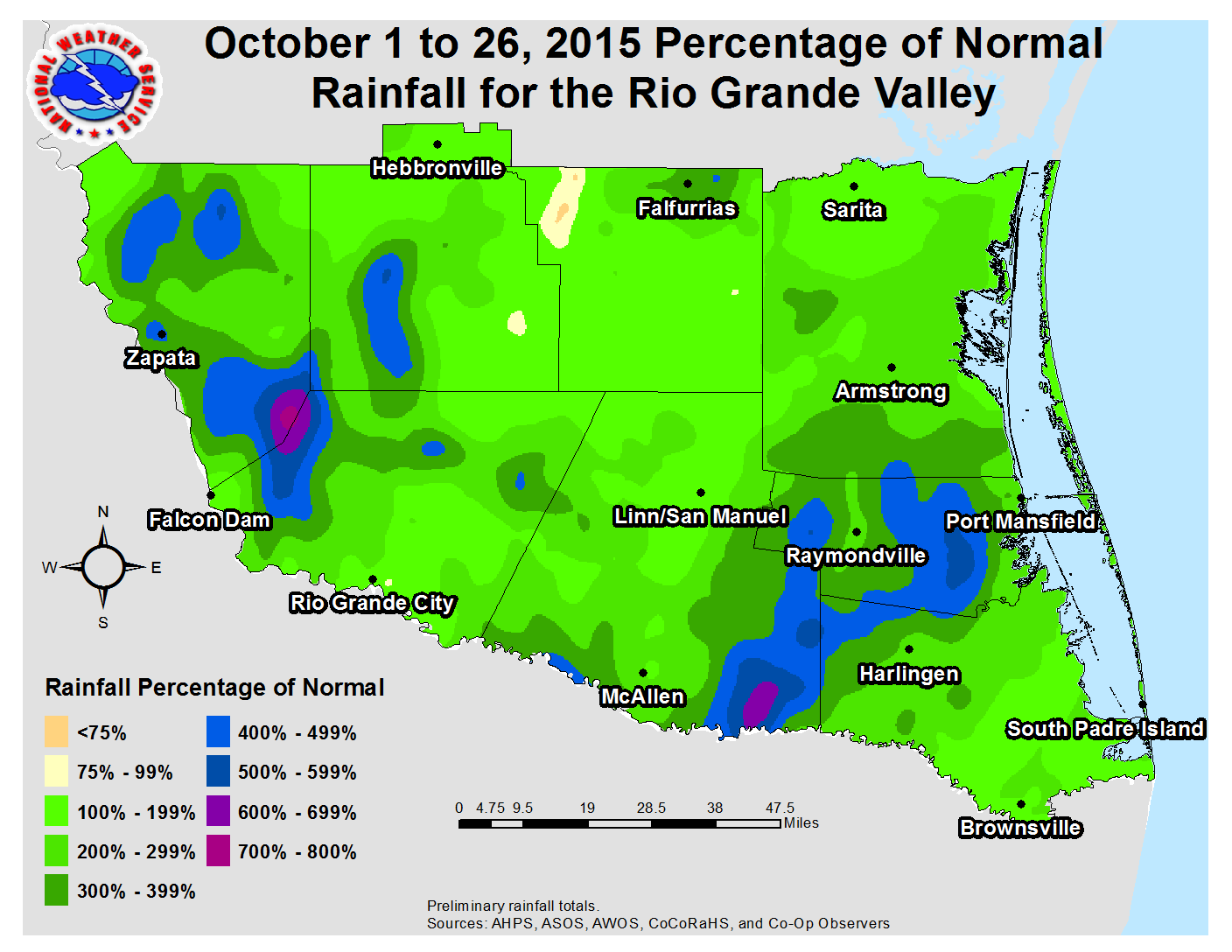 Comparative data based on 1981 to 2010 averages. |
|

