|
June 17th/18th: Hebbronville Hammer Becomes Mid Valley Soaker
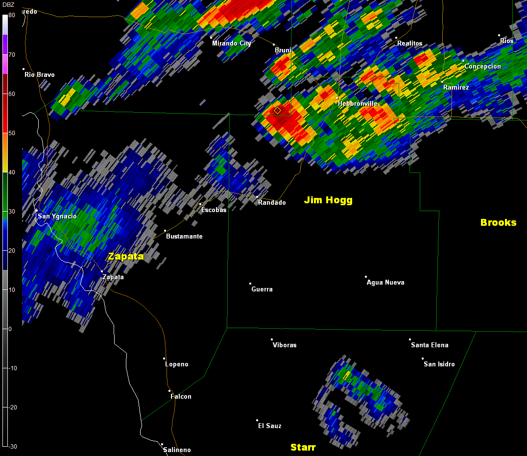
Tropical moisture flowing into northeast Mexico and Deep South Texas well behind Tropical Depression Bill, which had exited north Texas, was given a boost by a leftover upper level trough (energy) and boundaries from prior storms across the South Texas Brush Country on June 17th/early June 18th to trigger a band of repeating thunderstorms across central and north Jim Hogg County, stretching into northern Brooks County, during the mid evening of June 18th. Rainfall estimates ranged from 6 to 12 inches across northern Jim Hogg County, three to four times the monthly average in just one night! The very efficient rain created flash flooding Hebbronville between 630 PM and at least 9 PM on the 17th, including the following:
- One vehicle with water up to the hood, stuck at intersection of Galbraith and Willhelmina Avenue
- Water flowing over road at W. Galbraith and N. Maria Avenue, at an estimated depth of 2.5 feet
- Most streets flooded at some point during the storm, conditions reported to be "very bad" by the Hebbronville Fire Department

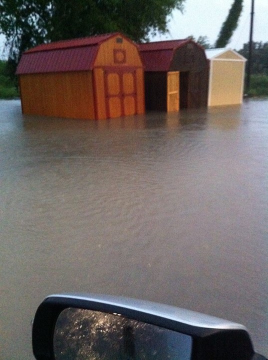
Flooding of 1 to 2 feet of water (estimated) to outbuildings at a property in Hebbronville, Texas, just after persistent torrential rains ended just before sunset on June 17th, 2015. Photo credit: Facebook.
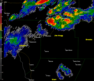
Doppler radar base reflectivity (0.5 °) from 601 to 803 PM, June 17, 2015, across Jim Hogg County, TX, and surrounding areas.
Midnight Mud: San Carlos Soaker
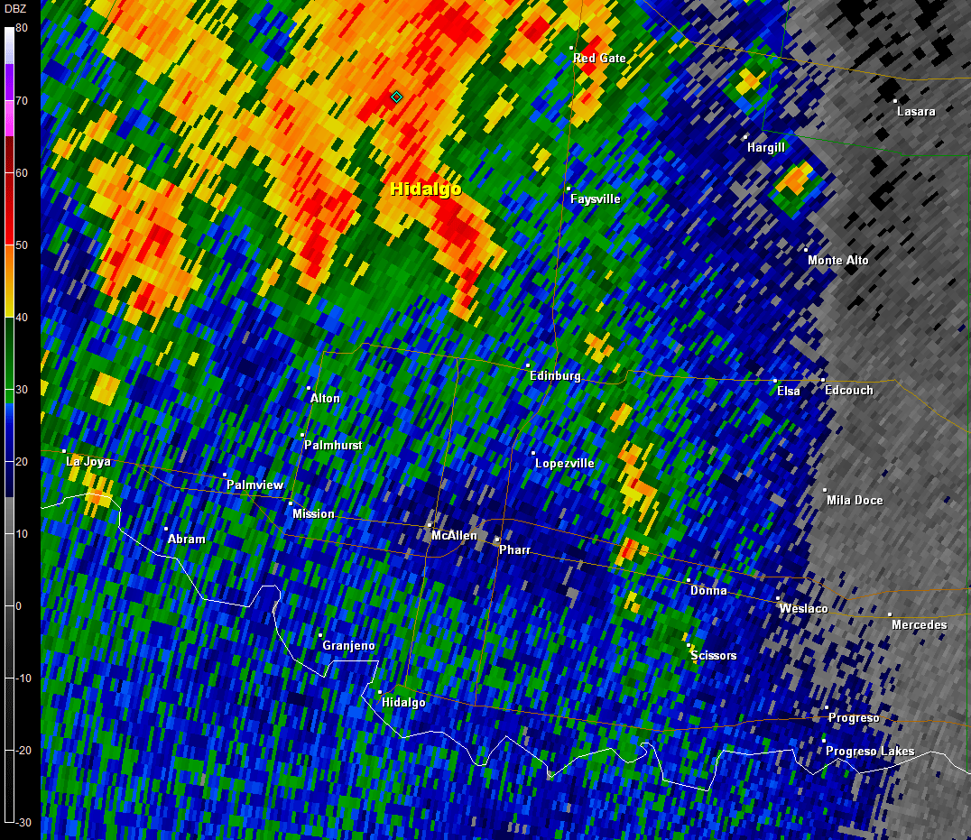
The South Texas Brush Country soaking rains eased toward the Upper Valley and hooked up with similar slow moving but intense storms edging north from Nuevo León and Tamaulipas during the late evening. With little atmospheric momentum to nudge them, additional torrential rains dropped one to three inches from extreme western Hidalgo County into northern Starr County. Just prior to midnight, an injection of energy met with the eastward "oozing" thunderstorm system, and a persistent south to north band of torrential rains lined up from near Muñiz to San Carlos (east/southeast of Edinburg) to Faysville between 11 PM and midnight, and continue developing southward to Pharr/Alamo/San Juan between midnight and 1 AM on the 18th (top of right column).
|

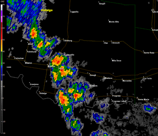
Doppler radar base reflectivity (0.5 °) from 1115 PM June 17 to 125 AM, June 18, 2015, along and just east of U.S. 281/Interstate 69C in central Hidalgo County.
Midnight Mud: San Carlos Soaker (continued)
Radar estimated rainfall of 2 to 4 inches in little more than an hour in any one location created flash flooding and residual high standing water through the following weekend (June 20/21) in subdivisions (colonias) of San Carlos that have notable poor drainage. Several families evacuated flooded homes after daybreak on the 18th; one report stated up to sixty homes were surrounded by water, with water reaching into a number of them. FEMA, who had already been aiding other communities in central Hidalgo County (Faysville, etc.) from the more than foot of rain that fell in mid–May, set up a temporary disaster assistance station at the local community center. Other mid–Valley flooding included water flowing into a home in Pharr, and up to two feet of water along State Road 495 between Tower and Border Road in north Alamo.
June 19th: Edinburg...Again??
Sometimes, meteorology bedevils the best forecasters in the world. On Friday, June 19th – an afternoon that was expected to be relatively tame with limited "big picture" atmospheric elements to trigger widespread soaking rain, became nightmarish in a five mile wide stretch that – coincidentally – was nearly the same area that was hammered 40 hours earlier. A thin convergence band of thunderstorms developed between McAllen and Edinburg around 4 PM, and built southeast along and just east of U.S. 281/Interstate 69C for the next three hours, pounding Edinburg, north San Juan, and San Carlos with 4 to 6 more inches of rainfall (4.25 officially recorded near downtown Edinburg). Mission and Elsa, no more than ten miles west and east, respectively, of the deluge, received nary a drop! Areas near San Carlos likely received eight inches (or more). The resulting issues were as follows (as of June 20th):
- $23 million in insured damage (estimated) in the Edinburg/San Carlos area from events of June 18th and June 19th alone
- Eleven families evacuated from a subdivision in east Edinburg near Tower and Minnesota Road
- In total, at least 150 homes were flooded in subdivisions from Edinburg to San Carlos, due to the double whammy of torrential flooding rains in 40 hours
- An American Red Cross shelter in San Carlos expected 25 to 28 persons to take up temporary residence until floodwaters receded
- Seven to more than a dozen roads closed across Edinburg due to high standing water.
Doppler radar base reflectivity (1.4 °) from 428 to 729 PM June 19, 2015, from Edinburg to points southeast. Note the heavy (red) storm cells repeating over the same area for nearly three hours.
|


