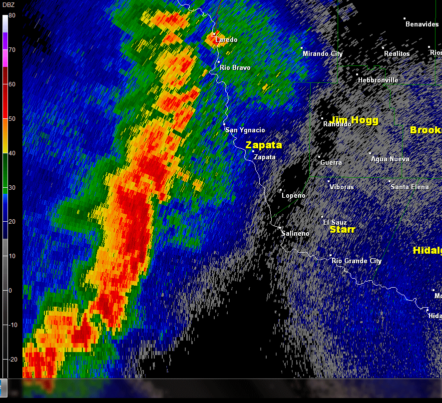
 0.5° Base Reflectivity loop from around 0915 PM through 11 PM May 23rd 2015. Note the bow–shaped area that raced into southern Zapata County; this is often an indicator of damaging winds near the apex of the bow. |
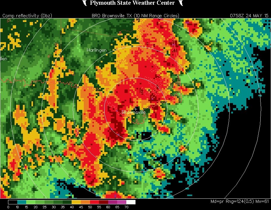 Composite Reflectivity loop from around 245 AM through 445 AM May 24 2015. Note the slow down of the line, with cells moving across the same areas toward the end of the loop. |
| Thunderstorm System Provided Flooding Rain, Strong Wind, and Another Light Show This Time, the Flooding Rains Reach the Lower Valley, May 24th 2015 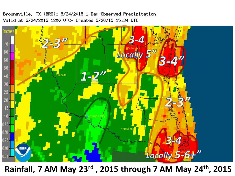 |
|
|
On yet another occasion – the third in six weeks – a thunderstorm system, known as a "Quasi–linear convective system", or QLCS for short, rolled across all of Deep South Texas and the Rio Grande Valley during the overnight hours of May 23/24, 2015. This particular system was well advertised by forecast models of all stripes, as a vigorous upper level disturbanced tracked slowly from southwest to northeast across west Texas during the afternoon and night of the 23rd/24th. Most of the life and property threatening action was in central Texas, where the combination of upper level energy and influx of rich, tropical moisture led to nearly a foot of rain across the Hill Country and produced record setting flash floods on rivers, which unfortunately swept hundreds of homes to their destruction and drowned several people. The southern tip of Texas fared better, but was not spared of the action. By early evening, a line of thunderstorms formed up in the lee of the Sierra Madre from west of Laredo to southwest of Starr County. As they pushed east, a segment of the line became ominously intense, shaped into a bow as it tore into southern Zapata County (above left) between 9 and 10 PM on the 23rd. Wind speeds at 16,000 feet at one point (below) reached over 100 mph just prior to the line arriving in Zapata County along the length of Falcon Lake; how much of those winds reached the ground is not yet known, but quite possibly range from 60 to 70 mph or more based on prior events this spring and in other years. The line quickly lost its punch tracking across Starr and Jim Hogg County, which spared the populated mid Valley another opportunity for notable wind damage. However, rain added up to an inch or so for many areas, and totalled more than two inches in areas north of Edinburg, still dealing with drainage issues from events two weeks earlier. Lightning was again an issue, the primary cause of up to several thousand customers losing power across the Valley during the peak of the storms. 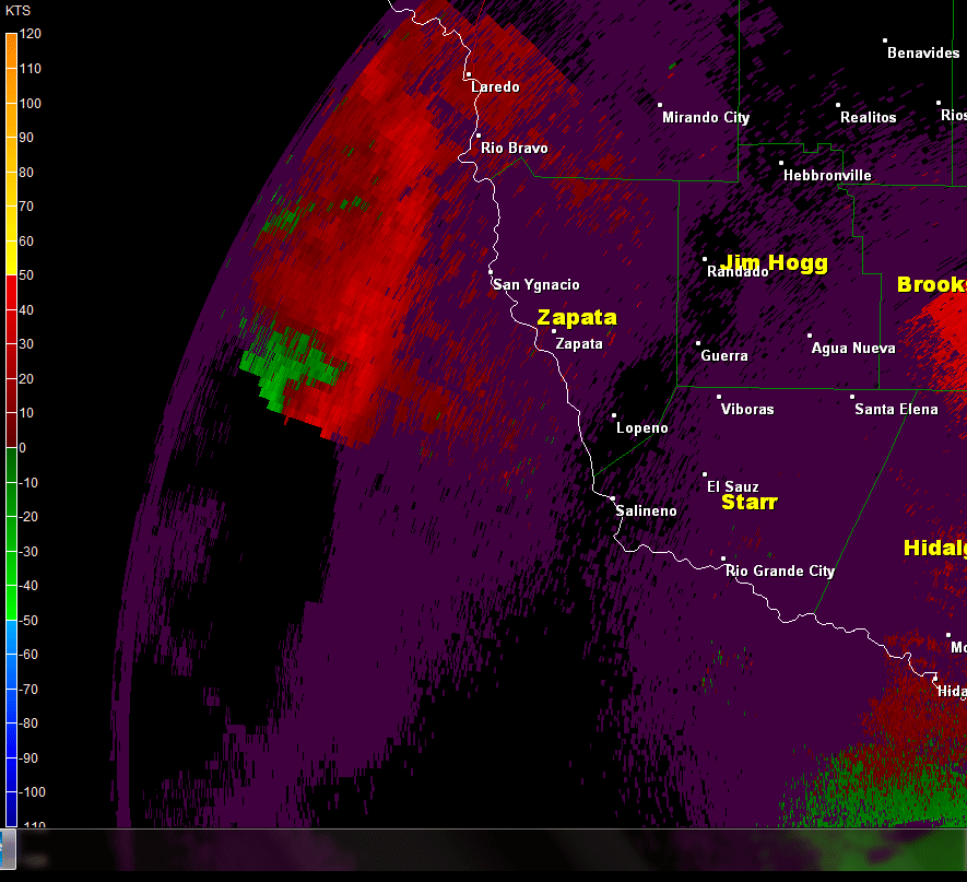 0.5° Base Velocity loop from around 0915 PM through 11 PM May 23rd 2015. Note the strong inbound winds between 13 and 16 thousand feet (dark blue) at the apex of the bow as they headed into southern Zapata County. These winds would quickly weaken as they headed closer to the populated Rio Grande Valley |
As the line eased into Hidalgo County, the wind threat abated but locally heavy rains continued. Between 2 and 3 AM, the line entered Cameron County and became reinvigorated, perhaps by low level convergence from east southeast winds from the Gulf of America. At the same time, the line slowed dramatically, with a few stronger cells tracking over the same areas for a two to three hour period. When all was said and done, southern Cameron County, which had been largely spared from May’s torrents, finally got into the act in a big way: Three to four inches fell across most of Brownsville, with pockets of 5 to 6 inches over the west side, including River Bend Golf Resort which saw widespread road, drainage, and resaca flooding. An estimated four to five inches fell east of Brownsville, perhaps including parts of Boca Chica Beach and South Padre Island, before daybreak on the 24th. High water continued through mid to late morning in many areas of southern Cameron County as rains slowly diminished. The torrents of the 24th added to locally heavy rainfall between Brownsville and San Benito on the 21st (courtesy of colliding boundaries from the west and southeast) to give some residents 5 to 7+ inches – more than 2 times the monthly average in some cases – in only three days (table, below). 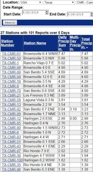 |
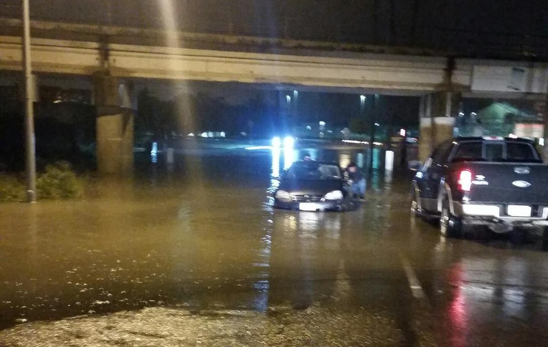 Photo of flooding and water rescue from vehicle on Mexico Boulevard, near the Brownsville and Matamoros Bridge, during the pre dawn hours of May 24th. Courtesy of City of Brownsville Office of Emergency Management. |
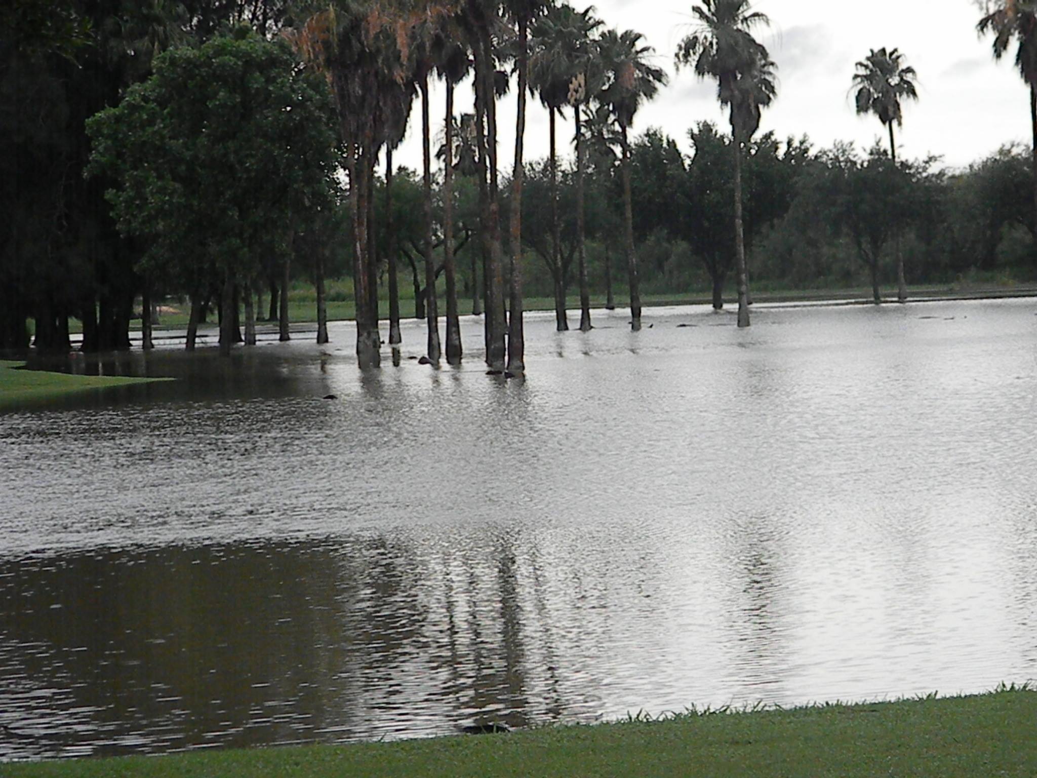 Photo of resaca overflowing golf course at River Bend (west Brownsville) well after the rains had ceased. The Community Collaborative Rain, Hail, and Snow Network (CoCoRaHS) observer who provided the photo had more than six inches during the storm. |
PRELIMINARY LOCAL STORM REPORT...SUMMARY
NATIONAL WEATHER SERVICE BROWNSVILLE TX
648 AM CDT SUN MAY 24 2015

..TIME...   ...EVENT...      ...CITY LOCATION...     ...LAT.LON...
..DATE...   ....MAG....      ..COUNTY LOCATION..ST.. ...SOURCE....
            ..REMARKS..

1208 AM     FLASH FLOOD      ZAPATA                  26.89N  99.26W
05/24/2015                   ZAPATA             TX   LAW ENFORCEMENT

            ZAPATA COUNTY SHERIFFS OFFICE REPORTS KNEE-HIGH WATER
            OVER THE ROAD IN MEDINA ADDITION DUE TO SWOLLEN ARROYOS.

1239 AM     FLASH FLOOD      ZAPATA                  26.89N  99.26W
05/24/2015                   ZAPATA             TX   FIRE DEPT/RESCUE

            ZAPATA COUNTY FIRE DEPARTMENT REPORTS 3 ROADS FLOODED
            BETWEEN 4TH STREET AND 7TH STREET FROM MIRAFLORES TO
            HIGHWAY 83. FLOODING IS DUE TO SWOLLEN ARROYOS WITH
            HEIGHT OF WATER ON ROADS SAID TO BE JUST BELOW THE KNEE.

0140 AM     TSTM WND GST     RAYMONDVILLE            26.48N  97.78W
05/24/2015  E60 MPH          WILLACY            TX   LAW ENFORCEMENT

            WILLACY COUNTY SHERIFFS OFFICE ESTIMATES WINDS OF 60
            MPH AT THEIR LOCATION.

0350 AM     FLASH FLOOD      BROWNSVILLE             25.93N  97.48W
05/24/2015                   CAMERON            TX   LAW ENFORCEMENT

            BROWNSVILLE POLICE DEPARTMENT REPORTS WATER 1 TO 1 1/2
            FEET DEEP AT THE INTERSECTION OF BATES AND DEWS NEAR THE
            BROWNSVILLE AND MATAMOROS INTERNATIONAL BRIDGE.

0423 AM     FLASH FLOOD      SOUTH PADRE ISLAND      26.08N  97.18W
05/24/2015                   CAMERON            TX   LAW ENFORCEMENT

            SOUTH PADRE ISLAND POLICE DEPARTMENT REPORTS FLOOD
            WATERS 12 INCHES TO KNEE DEEP ON SOME ROADS. ONLY CENTER
            LANE OPEN FROM 3500 TO 5000 PADRE BOULEVARD.
|
|

