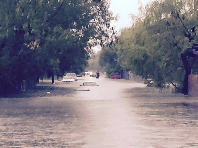
 Photos from the flooding in Brownsville during afternoon of August 31, 2015. Photos provided from social media sites, including NWS Brownsville, KGBT Action 4 News, and from City of Brownsville Emergency Management and NWS Brownsville/Rio Grande Valley employees.  |
|
| Super Soaking! For Brownsville, August 2015 Goes Out With a Bang |
|
|
Boom! Numerous vehicles were flooded, a school bus was trapped near Price Road and southbound U.S. (Expressway) 77 frontage, and dozens of properties had some water inundation, particularly west of the expressway. The City of Brownsville and the American Red Cross (South Texas) combined to open a shelter near downtown to accommodate impacted families, particularly in the Galaxia Colonia in the city's west side, where flooding was most severe. Though damage estimated were not available at the time of this writing, values are likely to rise into the millions of dollars.  Radar loop at storm’s most intense rainfall period in Greater Brownsville, August 31st from 242 until 415 PM CDT. Click for full resolution version. As the system drifted south, the rotation continued to tighten up. By the time the heaviest rains reached downtown Brownsville, a little before 4 PM, the system had morphed into a classic High Precipitation (HP) Supercell Thunderstorm. As downpours continued to flood much of Brownsville, on the cities south side, and into parts of Matamoros, Tamaulipas, the rotating updraft portion of the storm was clearly visible (image, bottom center). Doppler–derived velocity signatures (top right column) suggested a possible tornado in Tamaulipas at around 415 PM CDT; as of this writing, there had been no reports of damage though some videos were made available that suggest a funnel cloud may have formed well south of the Rio Grande. For some neighborhoods, the 6+ inches of rain was nearly three times the monthly average of around 2.5 inches, in less than three hours!. At Brownsville/South Padre Island International Airport, where official observations are kept, the 1.61 inches on the day punched the monthly totals over 3 inches (3.04), more than half an inch above average (2.44 inches). The last day rains ensured that nearly all of the Valley surpassed August normal rainfall, despite rain on just 2 to 4 days and the month most remembered for hot, dry weather. 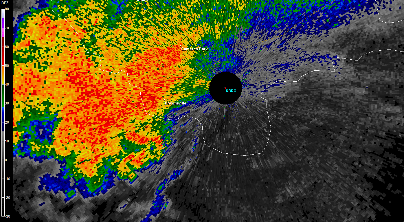 Radar loop of base reflectivity between 329 and 516 PM CDT in southern Cameron County and northeastern Tamaulipas (Mexico), when HP Supercell formed. Note the "hook" shaped area about five to ten miles south of the radar location. The hook indicates location of rotating updraft. 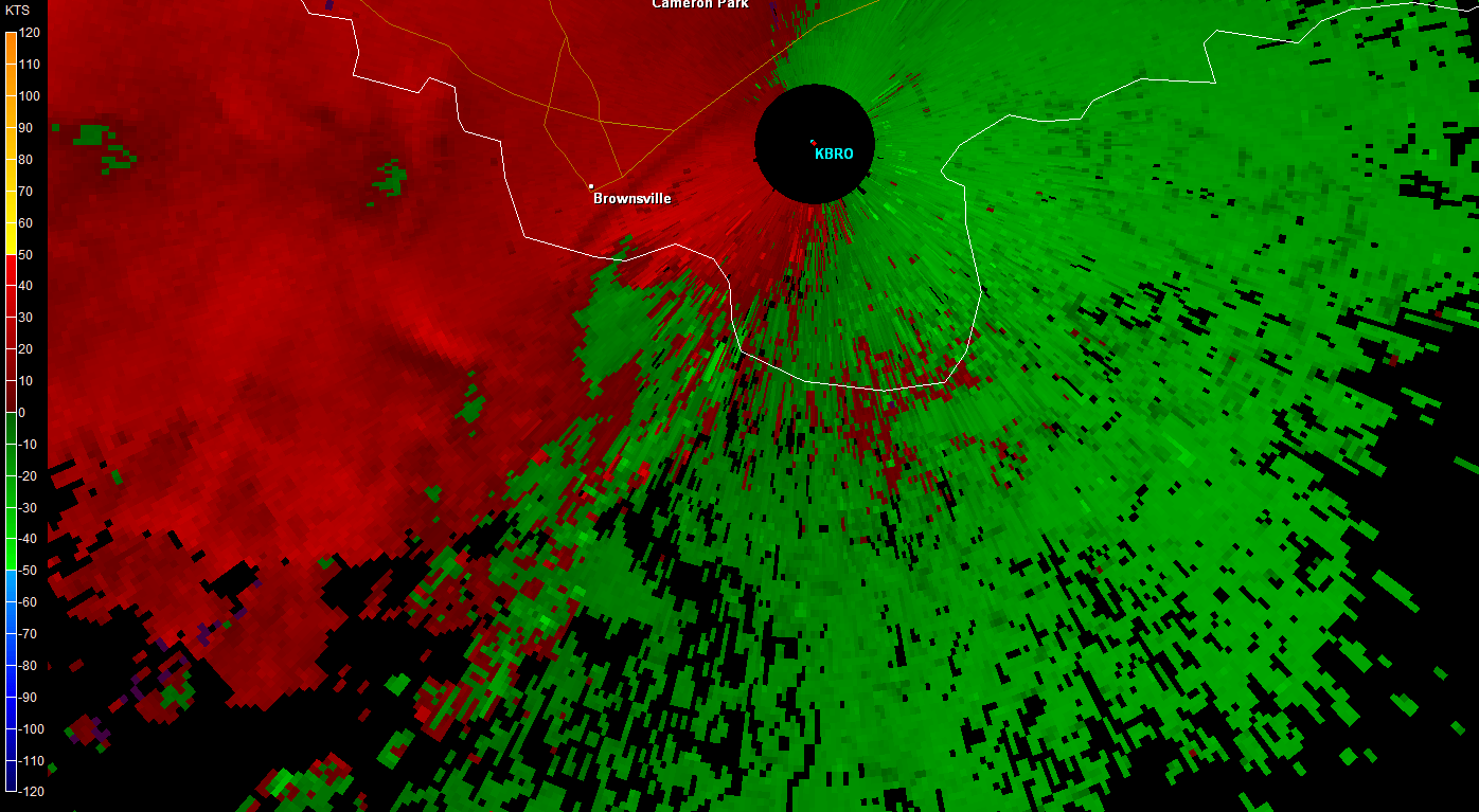 Radar loop of base velocity (approximately 1 to 2 thousand feet above ground) between 329 and 516 PM CDT in southern Cameron County and northeastern Tamaulipas (Mexico), when HP Supercell formed. Note the circular pocket of red next to green that slides south of the river from Brownsville, and a quick period when the colors come together with a spot of yellow, which was around 415 PM CDT. This pocket indicated the core of the updraft; while no tornado had been confirmed, one was possible around 415 PM over northern Tamaulipas. |
Some Reasons Why an HP Supercell Formed...Here The typical season for such supercells across the Rio Grande Valley favors spring and early summer, not the deeper tropical moisture time of late August. In hindsight, the atmospheric puzzle pieces came together to suggest the possibility of such a rare event for somewhere in the Rio Grande Valley. The morning atmospheric profile (first image below; click to enlarge) indicated sufficient moisture (very common) but something else: cooling well above the surface, more common to May and June than late August, and light but turning winds in the lower and mid levels of the atmosphere. Each parameter provided the opportunity for deep, rotating updrafts. That opportunity was enhanced further by a developing jet streak (higher winds) at ~35,000 feet above the ground (second image), which rotated around the base of a trough (upper level disturbance) of lower values centered near Brownsville. That streak may have contributed to allowing the updraft to deepen further, which would sustain a large slow moving rotating thunderstorms. Finally, in the mid levels of the atmosphere (~10,000 feet), ample moisture (also shown in the profile) was present, ensuring any rapidly developing cells would be able to be sustained high into the atmosphere for several hours. More research needs to be conducted to try to unlock all the reasons why the perfect updraft formed near Brownsville, but some signposts were evident earlier in the day. 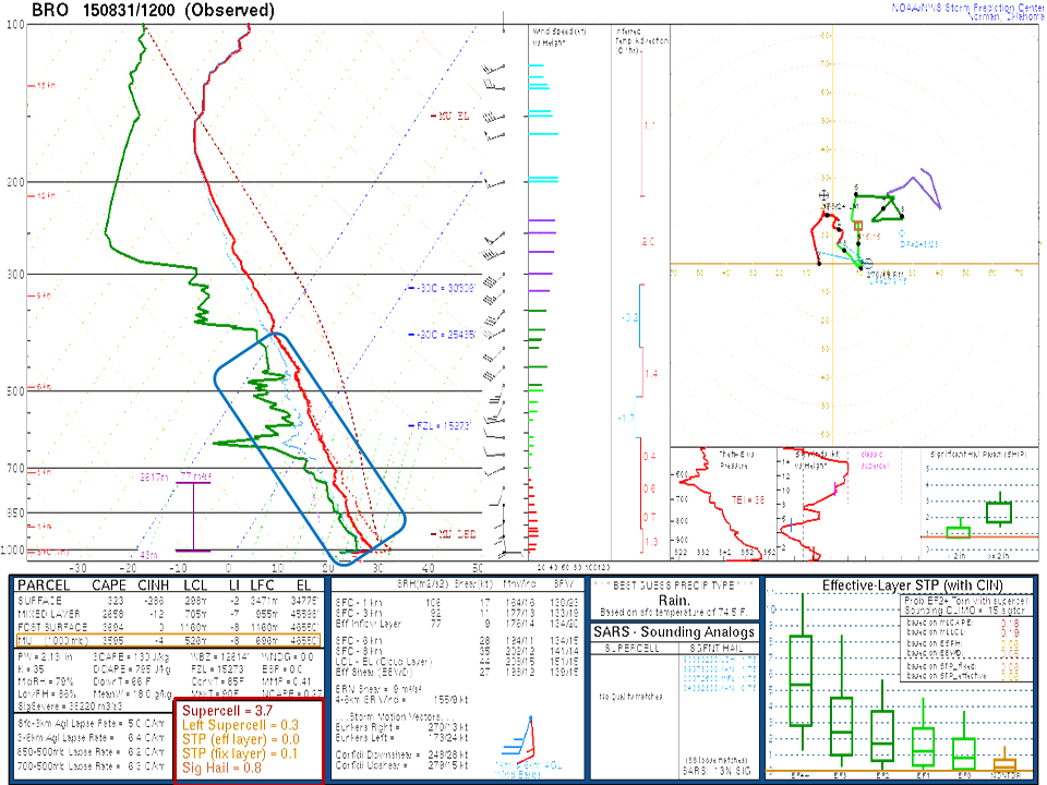 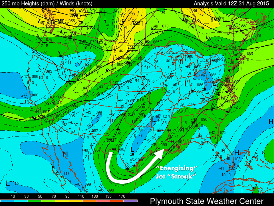 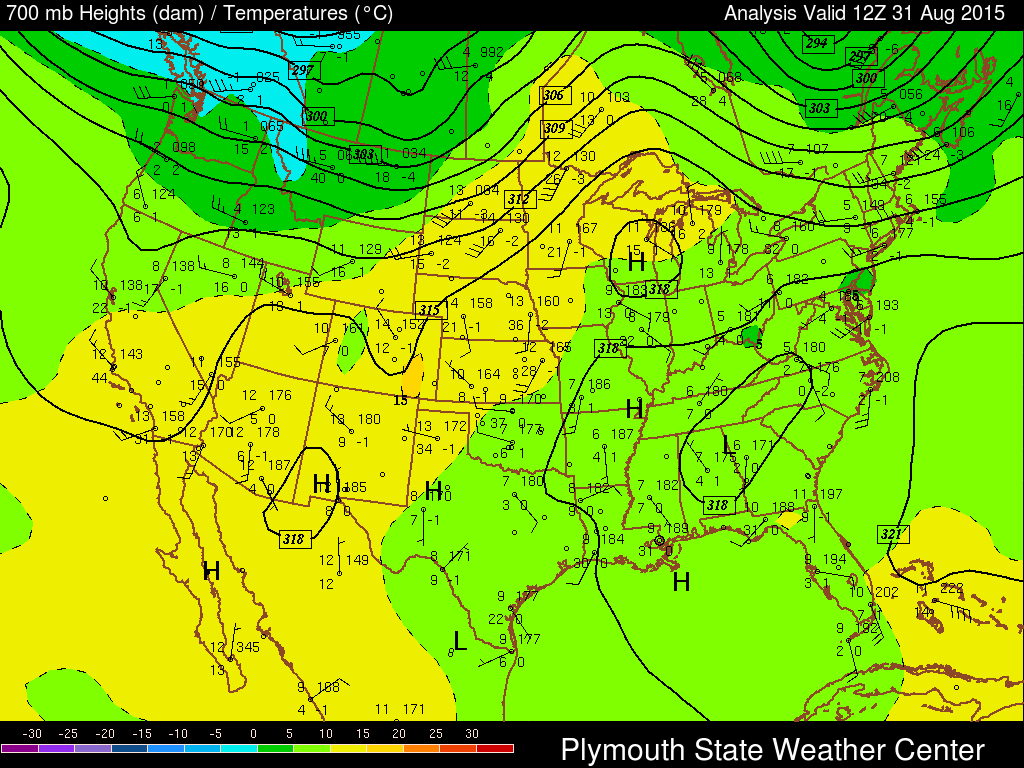 Above: Top – Atmospheric sounding, 7 AM August 31, 2015, from Brownsville. Note the area of deep moisture (inside blue outline) but also the Supercell Index (red outline) of 3.8, which is relatively significant any time of year for the Lower Rio Grande Valley. Middle: Upper level steering flow, 250 millibars (~35,000 feet). White arrow indicates area where a jet "streak" rotated around the upper level disturbance during the day and may have provided additional ability for updrafts to sustain very high in the atmosphere. Bottom: Mid level steering flow and moisture, 700 mb. Note sufficient moisture (green) for thunderstorms to grow; light winds from the south favor continued influx associated with upper level disturbance which was parked over the Lower Valley. Click to enlarge each image. |
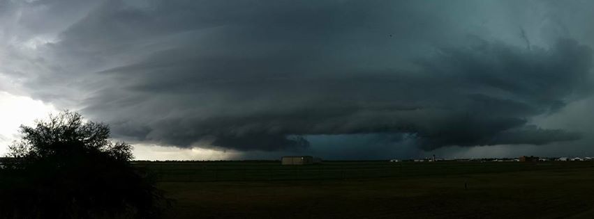 Not in Kansas anymore, Toto! Panoramic image of rotating "corkscrew" updraft portion of HP Supercell thunderstorm that created widespread flooding in Brownsville on August 31, 2015, just before 4 PM. The storm may have dropped a funnel south of the border in Tamaulipas, Mexico; reports had not been received or confirmed as of this writing. For a great time lapse video, which made video news feeds on September 1st national news shows and The Weather Channel, click here. |
|

